Category Archives: Salt Lake County

Thomas Kearns Mansion and Carriage House

Published / by Brooklyn Lancaster / 4 Comments on Thomas Kearns Mansion and Carriage House

Write up by: Brooklyn Lancaster

Marker placed by: The National Registry of Historic Places

Coordinates: 40.7698° N, 111.8741° W
603 E. South Temple St., Salt Lake City, Utah, 84102


Marker Transcript:
Utah Historic Site
Thomas Kearns Mansion and Carriage House
Built 1900-1902 of Sanpete Limestone.
Architect Carl M. Neuhausen.
Governor’s Mansion 1937-1957.
Division of State History N-1

National Register Plaque

Extended Research:
Thomas Kearns was born in Canada in l862. His family then moved to a farm in Nebraska in 1870. Thomas didn’t grow up with a lot of money. When he was 17 years old, he left his family’s farm to look for a job. He ended up working different mines in South Dakota as well as Arizona. He then heard about Park City while riding on a train. He decided to head to Park City in 1883 hoping to make it big.

While mining in Park City Thomas discovered that there was an untapped silver vein in a mine called the Mayflower. He decided to lease the Mayflower with the help of two of his friends, David Keith and John Judge. On April 15, l889, they struck “gold,” or in this case silver. Over the next few years, Thomas and his partners bought several nearby mines, including the Silver King. The Silver King was one of the greatest silver mines in the world. It soon made Thomas and his partners very wealthy.

Once the railroad made its way to Utah in 1869, people from all over the world came to Utah hoping to make it rich in Utah’s mines. While this worked for some, others made money off of supplying goods for the miners. The people who struck it rich started to build impressive homes on the most desirable street in Salt Lake City at the time–South Temple. Even Brigham Young, an important local church leader, had several homes on the street. Other important pioneer leaders also built houses on the street.

By 1899, Thomas Kearns’s partners had both built mansions on South Temple which led Thomas to follow their example and buy some land to build his own mansion. After buying land Thomas hired architect Carl Neuhausen to design his home for him. The building of the mansion took from 1900 to 1902.

Thomas wanted his home to be the most modern and up to date, including the latest technology. He had electric lights, steam-heated radiators, a call board, and dumb waiters all installed in his home. Thomas even had one of the first indoor showers in Utah. The mansion also had a bowling alley, though all the pins had to be placed by hand. Jennie Kearns, Thomas’ wife, went all the way to Europe with their children to find art and furniture to decorate the mansion. They wanted the best of the best when it came to their home.

The Front of the Kearns Mansion

Architect Carl Neuhausen wanted the Kearns Mansion to look like a French castle. Each side of the mansion is designed differently. The mansion also has turrets on three of the four corners. The walls are made of limestone and have carvings around the windows and doors. Besides the mansion, the Kearns family also had a carriage house. Thomas was a great horse lover and had eight carriages. Once cars became more popular, the Kearns family stored their cars in the carriage house instead. Thomas Kearns was one of the first people to buy a car in Utah. However, he never actually learned to drive it.

The Carriage House

In 1938 the Kearns Mansion was renovated to become the Utah’s Governor’s Mansion. Governor Henry Blood and his family were the first governor’s family to live in the Kearns Mansion. It was then used as the home of the governor until 1959 when George D. Clyde became governor. He refused to live in the mansion. Subsequently, a new home was then built for the then governor. Besides Governor Clyde, Governor Calvin Rampton, was the only other governor to not live in the Kearns Mansion after it became the official residence of the governor. [1]

With the Governor moving out, the Utah State Historical Society decided to move in. Sadly, they didn’t have the funds to truly keep the mansion in good shape. The mansion became more and more run down over the subsequent years. It wasn’t until 1976, when Governor Scott Matheson was elected, that the mansion was given an update and repaired. The Governor then decided to move his family into the mansion in 1980. 

The mansion was used as the Governor of Utah’s residence all the way up to December of 1993. That was when Governor Mike Leavitt’s family Christmas tree caught fire in the Grand Hall.[2] The fire spread quickly. Luckily everyone was able to get out of the building without injury but much of the house was destroyed. Priceless woodwork, hand-carved and painted decorations, art, fabric, and furniture were charred and gone. During the restoration of the Kearns Mansion officials decided to return the home to its 1900s roots. While still updating the electrical wiring, plumbing, and heating they tried to make it look like it did when the Kearns family lived in the home. 

During the life of the Kearns Mansion it has been a family home, a Governor’s residence, as well as an office for the Utah State Historical Society. It has been nearly burned to the ground and then fully restored. It is still standing after over a hundred years, sharing the history of the Kearns family, Salt Lake City, and Utah with everyone who visits. In 2020, it is still in use as the governor’s mansion for Utah governor Gary Herbert.

[1] The Governor’s decision to vacate the Kearns’ Mansion was a controversial one because of the fact that the Kearns’ family had donated the mansion for that use.

[2] While the Governor was not at home at the time of the fire his family was.  

For Further Reference:

Primary Sources:
“Fire, Smoke and Repairs.” Governor Seal. Accessed January 30, 2020. https://governor.utah.gov/mansion/mansion_firesmoke/.

“Historic Utah Governor’s Mansion Reopens”, press release and program. Accessed January 30, 2020. http://archive.li.suu.edu/docs/ms122/PD/ms122b1996bf00617.pdf.

Secondary Sources:
“Fire, Smoke and Repairs.” Governor Seal. Accessed January 30, 2020.https://governor.utah.gov/mansion/mansion_firesmoke/.

Kued. “The Governor’s Mansion – PBS Utah Productions.” PBSUtah.org, February 1, 2019. https://www.pbsutah.org/whatson/kued-productions/the-governors-mansion.

“KEARNS, THOMAS.” Utah History Encyclopedia. Accessed March 18, 2020. https://www.uen.org/utah_history_encyclopedia/k/KEARNS_THOMAS.shtml.

Wilson, Martin and Susan Holt, Rob Pett, Ellie Sonntag, “The Governor’s Mansion: Ready for Utah’s Second Century,” Utah Preservation, Vol. 1, 1997: 10-19. Issuu. Accessed March 18, 2020. https://issuu.com/utah10/docs/utahpreservation_volume1.

Utah State History. “Utah Preservation Restoration, Volume 2, 1980.” Issuu. Accessed March 20, 2020. https://issuu.com/utah10/docs/utahpreservationrestoration_volume2.

U.S.S. Utah Bell

Published / by Matt Peplin / 1 Comment on U.S.S. Utah Bell
The bell in its current display

Write-up by Matt Peplin

Placed by: Naval History and Heritage Command

GPS Coordinates: 40° 46’ 0.408” N 111° 50’ 56.94” W

Historical Marker located on each side of bell
Plaque just left of bell from first image

Historical Marker Text: Main Ship’s bell from the USS Utah (BB-31) bronze with later painting of bell shoulder and lip. Originally installed suspended and used for ship functions and ceremonies. It is uncertain if the bell was still on board the Utah in 1941. Conservation treatment completed and bell reinstalled at the University of Utah in 2017.

Courtesy of Naval History and Heritage Command, Catalog No. 2016.048.001

Plaque Reads: U.S.S. UTAH 31 AUG. 1911 7 DEC. 1941

Bell Reads: U.S.S. UTAH 1911

Extended Research:

Built by the New York Shipbuilding Company, the U.S.S. Utah launched on December 23, 1909 from Camden, NJ. The ship was sponsored by Mary Alice Spry, daughter of former Utah Governor William Spry and commissioned August 31, 1911 in the Philadelphia Navy Yard. The ship spent most of its early years as a training vessel, operating across the eastern seaboard from as far North as New England and as far South as Cuba. The Utah saw its first “action” in April of 1914 in Veracruz, Mexico. Its battalion at the time (17 officers and 367 sailors) successfully seized the Veracruz customs house, preventing the Germans from supplying arms and munitions to the Mexican dictator, Victoriano Huerta. Seven men were awarded Medals of Honor for their roles the operation. [1]

BB-31 during trials in 1911 (Courtesy of Naval History and Heritage Command)

When the United States entered World War I in 1917, the Utah reported to Bantry Bay, Ireland to help escort Allied convoys to the British Isles. Once the hostilities of World War I ended, the Utah participated in the honorary escort of President Woodrow Wilson to France (aboard the George Washington) for the eventual signing of the Treaty of Versailles. In the interwar period, the Utah continued a regular schedule of battle practices and maneuvers. On October 31, 1925 the ship was briefly decommissioned to undergo modernization, switching from coal to oil fuel, among other changes. Notably, the Utah transported President Hoover to South America and back in the winter of 1925. [2]

BB-31 photographed in WW1 with camouflage on hull (Courtesy of Naval History and Heritage Command)

On July 1, 1931 the Utah, in accordance with the 1922 Washington Naval Treaty, converted from a battleship (BB-31) to a mobile target (AG-16) in the Norfolk Navy Yard. The ship was equipped with a radio control apparatus that could adjust the ship’s speed and course without human hands, among other changes that made it more suitable for training exercises. As a mobile target, the ship was an invaluable teaching tool that gave US navy pilots a realistic objective to practice torpedo bombing, among other maneuvers. The Utah was instrumental in training the next generation of US sailors, who fought in World War 2. After transitioning to a mobile target, the Utah spent the rest of the 1930s on the west coast, primarily off the shores of California. [3]

AG-16 off the coast of Long Beach, CA in 1935 (Courtesy of Naval History and Heritage Command)
Wreckage of the Utah in Pearl Harbor, February 1944 (Courtesy of Naval History and Heritage Command)

The Utah moved from California to Pearl Harbor, Hawaii in September of 1941, the same place it was on the morning of December 7, 1941. The highest ranking officer on the ship at the time was Lieutenant Commander Solomon Isquith, who described the events as follows, “On Sunday, December 7, 1941, while moored at Berth FOX-11 Pearl Harbor, T.H., 3 planes whose identification were not questioned but taken for U.S. planes maneuvering, were observed just as colors were being hoisted at 0800, heading northerly from the harbor entrance. They made a low dive on the southern end of Ford Island and each dropped a bomb.” Isquith adds, “At about 0812, the last mooring lines had parted and the ship was capsized, the keel plainly showing. All men picked up by ship’s boats were taken ashore to Ford Island and boats ordered to return and pick up any men still swimming about.” [4] The Utah sank within the first 10 minutes of the events of Pearl Harbor. Its hulk remains there today. Six officers and fifty-two men from the ship lost their lives. [5]

AG-16 (or BB-31) represented the state it got its name from admirably, providing 30 years of service for this great nation. Some parallels can be drawn between Utah, the state and Utah, the ship. Like the ship, the state of Utah was used for training, preparing, and supplying soldiers for the realities of World War II. The Wendover Air Force Base and its surrounding salt flats helped prepare numerous American airmen and Salt Lake City served as a manufacturing and logistical hub for the army in the West. While the ship is often overshadowed by the U.S.S. Arizona in the tragedy of Pearl Harbor, the state’s WWII contributions are usually overlooked. [6] The outbreak of WWII (in the US) may have sunk the ship, yet the war brought in a tidal wave of jobs and economic activity to the state. The state’s fourteen military installations created nearly 40,000 jobs over the course of the war and the state’s population increased 25% from 1940-1950. The war also transformed the lives of the over 62,000 Utahns who served in WWII, with 3,660 Utahns paying the ultimate price for their nation. Perhaps the Utah and its now memorialized bell can serve as a reminder of the incredible hard work and sacrifice made by thousands of Utahns throughout this period of our nation’s history. [7]

The bell in its original display, outside the Naval Sciences Building on the campus of the University of Utah (Courtesy of the Marriott Library)

The U.S.S Utah Bell and Plaque are located in the Naval Sciences building on the campus of the University of Utah. It was originally donated to the University of Utah in approximately 1965. The bell arrived in Utah from Hawaii after then-Senator Wallace Bennett arranged for the Navy to ship it on an indefinite loan. Rear Adm. E.M. Eller wrote to Bennett on March 14, 1961, “My Dear Senator, the display of this fine relic should make a splendid memorial to the hardy naval [vessel] that bore the name of Utah for 30 years in our country’s service and to the gallant sons of the Beehive State who contributed so nobly to the heroic traditions of the naval service.” [8] The bell sat outside the Naval Sciences building until August of 2016, when it went back east for a stay at the Naval War College’s Senior Enlisted Academy in Newport, Rhode Island. The bell sat in Tomich Hall to commemorate the 27th anniversary of the facility, named after Chief Wartender Peter Tomich, who heroically went down with the ship in Pearl Harbor. After the brief stay in Rhode Island, it went to Richmond, Virginia to undergo a restoration process. It returned to the University of Utah on December 7, 2017 (the 76th anniversary of the Pearl Harbor attack) and placed where it now sits, inside the Naval Sciences Building. [9]

[1] Cressman, Robert J.. “Utah I (Battleship No. 31),” Naval History and Heritage Command, last modified May 19, 2019. https://www.history.navy.mil/research/histories/ship-histories/danfs/u/utah.html  

[2] Cressman, “Utah I.”

[3] Cressman, “Utah I.”

[4] Isquith, Lieutenant Commander S.S.. “USS Utah, Report of Pearl Harbor Attack”, Naval History and Heritage Command, report from December 15, 1941.

[5] Cressman, “Utah I.”

[6] Launius, Roger D. “World War II in Utah,” Utah History Encyclopedia, accessed April 2, 2020

[7] Launius, “World War II.”

[8] Ernest M. Eller, correspondence to Wallace F. Bennett, March 14, 1961. Quoted in Rolly, Paul. “To mark Pearl Harbor Day, the bell from the sunken USS Utah returns to the Beehive State, sounding the toll of history,” The Salt Lake Tribune, December 7, 2017. https://www.sltrib.com/news/politics/2017/12/07/to-mark-pearl-harbor-day-the-bell-from-the-sunken-uss-utah-returns-to-the-beehive-state-sounding-the-toll-of-history/

[9] Rolly, Paul. “To mark Pearl Harbor Day, the bell from the sunken USS Utah returns to the Beehive State, sounding the toll of history,” The Salt Lake Tribune, December 7, 2017. https://www.sltrib.com/news/politics/2017/12/07/to-mark-pearl-harbor-day-the-bell-from-the-sunken-uss-utah-returns-to-the-beehive-state-sounding-the-toll-of-history/

For Further Reference:

Primary Sources:

Isquith, Lieutenant Commander S.S.. “USS Utah, Report of Pearl Harbor Attack”, Naval History and Heritage Command, report from December 15, 1941. https://www.history.navy.mil/research/archives/digitized-collections/action-reports/wwii-pearl-harbor-attack/ships-s-z/uss-utah-ag-16-action-report.html

Secondary Sources:

Cressman, Robert J.. “Utah I (Battleship No. 31),” Naval History and Heritage Command, last   modified May 19, 2019. https://www.history.navy.mil/research/histories/ship-histories/danfs/u/utah.html

Launius, Roger D.. “World War II in Utah,” Utah History Encyclopedia, accessed April 2, 2020. https://www.uen.org/utah_history_encyclopedia/w/WWII.shtml

Rolly, Paul. “To mark Pearl Harbor Day, the bell from the sunken USS Utah returns to the Beehive State, sounding the toll of history,” The Salt Lake Tribune, December 7, 2017. https://www.sltrib.com/news/politics/2017/12/07/to-mark-pearl-harbor-day-the-bell-from-the-sunken-uss-utah-returns-to-the-beehive-state-sounding-the-toll-of-history/

“U.S.S. Utah Ship’s Bell Goes to NROTC Unit,” Utah Daily Chronicle, February 2, 1966. https://newspapers.lib.utah.edu/details?id=22447115&q=U.S.S.+Utah+&sort=rel

L.D.S. Tenth Ward Square

Published / by Katie Katz / 1 Comment on L.D.S. Tenth Ward Square

Write-up by Katie Katz

Placed by: The National Register of Historic Places, Site Number N-159

GPS Coordinates: 40°45’ 38’’ N 111°52’ 6’’ W

Historical Marker Text: 

L.D.S. Tenth Ward Square. As a result of the organization of the original nineteen wards of The Church of Jesus Christ of Latter-day Saints (Mormon) in Salt Lake City on February 22, 1849, ward squares or blocks were created on which the public buildings for each ward were constructed. Of the original squares, only the Tenth Ward Square retains the building which served the settlers’ spiritual, economic, cultural and educational needs. Still standing are the 1873 meetinghouse, the first building used exclusively for religious purposes; the third school house, built in 1887 and one of the earliest known designs of Richard K.A. Kletting, prominent architect and German immigrant of 1883; the late gothic revival church constructed in 1909; and the Tenth Ward store in 1880. The store is connected to a house which was built in 1890’s by Adam Speirs, bishop and proprietor of the store. Originally the Tenth Ward was bounded by Sixth East on the west, the foothills on the east, Third South on the north and Sixth South on the south. The first bishopric of the Tenth Ward consisted of: David Pettegrew, bishop, with Daniel Tyler, first counselor and Sanford Porter, second counselor. All three of these men were members of the Mormon Battalion.

1909 chapel (left) and 1873 building (right)

Extended Research:

The Tenth Ward building has a long heritage in The Church of Jesus Christ of Latter-day Saints; the ward’s history dates back as far as February 22, 1849.[1]At that time, the Salt Lake Stake (a geographically based religious unit in the LDS tradition) divided land in the Salt Lake Valley into nineteen wards with nine blocks for each ward.[2]Members of the Tenth Ward constructed various buildings over the years for religious and educational purposes, not all of which survive to the present. First in 1849, the members built a one-story structure for their religious meetings and school, but by 1853 the building was modified to make way for a two-story building for religious meetings, school, and a theater.[3]This building was demolished in 1898 and the stone lintel was used for the entryway of the chapel that was built in 1909.[4]In 1873, ward members built a brick meetinghouse, in the Greek Revival style of architecture, that was strictly used for religious purposes.[5]The Greek Revival style was used because of its rising popularity in the 1800s. This building is still standing today. It is the oldest of all the buildings currently on the Tenth Ward square.[6]In addition, this ward meetinghouse is the oldest meetinghouse still in use today in The Church of Jesus Christ of Latter-day Saints.

Inside of 1873 meetinghouse

Ward members next added a schoolhouse to the three-part building currently standing on the Tenth Ward square. Erected in 1887, the schoolhouse is located on the corner of 800 East and 400 South. This building is said to be one of the first structures that the famous Utah architect Richard Kletting designed. This building is significant because it was the original District Schoolhouse for Salt Lake City until 1890.[7]

In 1909, the congregation constructed the final addition to their historic building, its worship space, even though it was not dedicated until February 13, 1916.[8]President Joseph F. Smith, then leader of the Church of Jesus Christ of Latter-day Saints delivered the dedicatory sermon and prayer.[9]Right before his sermon, Smith commended the ward for staying out of debt and submitting their building collection fund in a timely manner.[10]Ironically, leaders of the Tenth Ward seemed to have collected the funds in just the nick of time. Only a week before the dedication service, a meeting note from Tenth Ward leaders stated “it is urgently requested that the collection for the building fund [be] collected… so that we may be able to pay off all indebtedness” before the dedication.[11]

1909 chapel (Stained-glass windows visible on the right side)

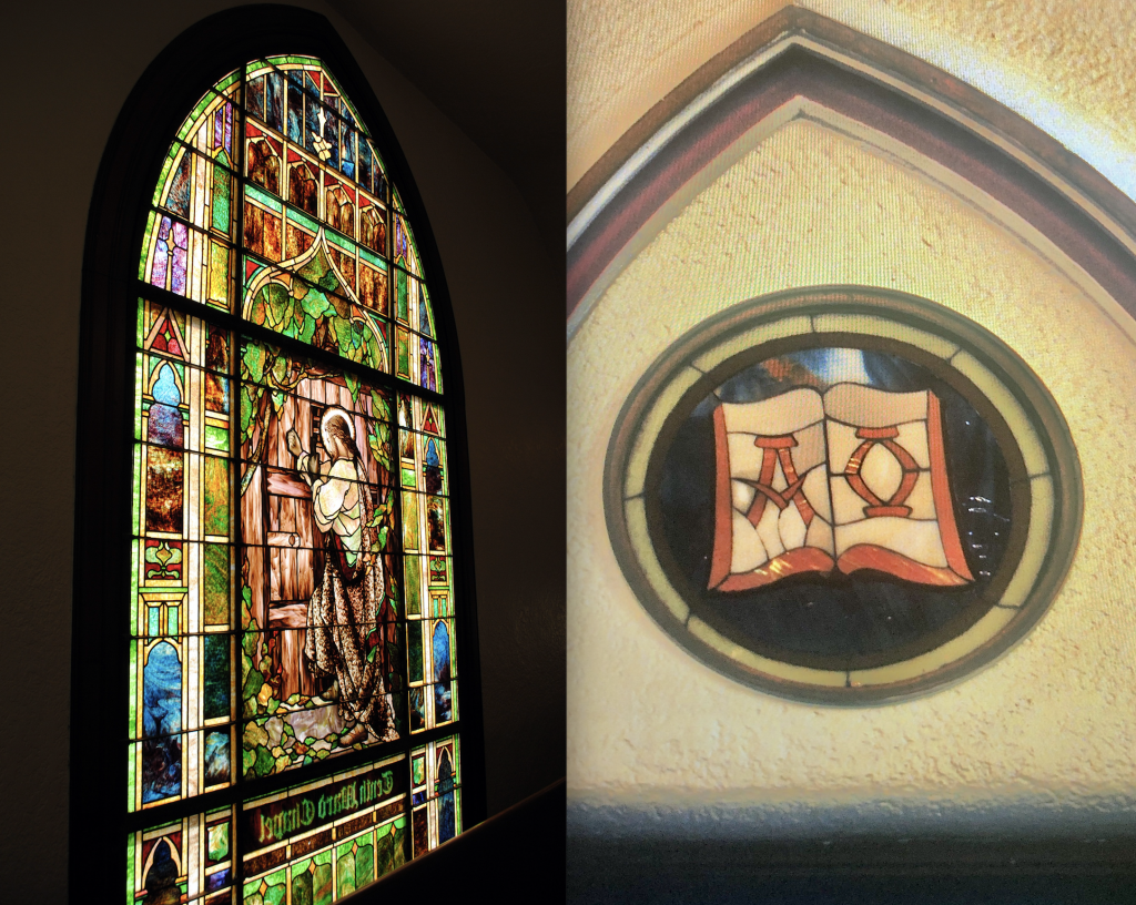
This last addition became the new chapel for the Tenth Ward to house its religious meetings. This section of the building is well-known and loved by many, but especially the members of the Tenth Ward. The chapel, a Gothic Revival style designed by Ashton Brothers architects, includes stained-glass windows, a steeple pointed roof, and a custom organ to accompany the choir. The organ stands out to all who visit the church both because of its beauty and because the sound it produces is wonderful to hear. The stained-glass images used in this building have symbolism rooted within the teachings of the Church. An example of this is the image of a beehive above a couple of windows. Beehives are an image the LDS Church uses often to symbolize its members working together, like bees within a hive. Another example is an image of a book with the Greek symbols alpha and omega on the pages. This is a representation of a scriptural passage in the Bible’s Book of Revelations, where it talks of Christ being the “Alpha and Omega,” or “the beginning and the ending.”[12]The most beloved stained-glass window, however, is located above the balcony, where natural light illuminates a picture of Christ knocking on a door, waiting to be let in.

Stained-glass window above balcony (left) and stained-glass “Alpha and Omega” (right)

As The Church of Jesus Christ of Latter-day Saints had done with other old meetinghouses, in the late 1990s it considered demolishing the building and erecting a new meetinghouse in its place. This news created considerable opposition from many people within the Tenth Ward, even though they understood the logic behind it because restoring the building would cost so much money. Gordon B. Hinckley, then President of The Church of Jesus Christ of Latter-day Saints had a personal connection to the Tenth Ward building and as a result also came to oppose its destruction. In 1983, Hinckley had shared in the Ensign magazine, an LDS publication, that it was in the balcony of the Tenth Ward building, during an opening song, “Praise to the Man,” that he gained his own personal faith in the gospel and the church he would one day lead.[13]

Hinckley thus decided that he would not let the building that meant so much to him be torn down. The LDS Church therefore, changed its plans for the Tenth Ward building from demolishing it to restoring it and updating it to meet modern building codes. The renovations of the building took two and a half years and cost three million dollars to complete.[14]The project aimed to keep the building’s interior as close to the original as possible. For instance, in the chapel the workers only changed the carpet and gave more spacing between the pews but kept everything else the same. 

On January 2, 2000, the Tenth Ward building was rededicated as a place of worship. Members of the Tenth Ward still use it for this purpose today.[15]Ultimately, with the help of modern renovations, the Tenth Ward building stands as the oldest church building still in use in The Church of Jesus Christ of Latter-day Saints, solidifying the building’s place as a Utah historical landmark. Recognizing this fact, the National Register of Historical Places submitted a nomination for the Tenth Ward Building to become a Utah Historical Site on April 4, 1977.[16]

[1]Julia A. Dockstader, “Chapel’s Heritage Lives On,” Church News, 25 January 2001, https://www.thechurchnews.com/archives/2001-01-27/chapels-heritage-lives-on-115947.

[2]Dockstader, “Chapel’s Heritage.”

[3]Lisa Thompson, “Renovation Transforms SLC’s 10th Ward from a Maze to Amazing,” The Utah Heritage Foundation Newsletter, January 2000, 1.

[4]Thompson, “Renovation Transforms,” 1.

[5]Thompson, “Renovation Transforms,” 1.

[6]Thompson, “Renovation Transforms,” 1.

[7]Thompson, “Renovation Transforms,” 1.

[8]“Passing Events,” Improvement Era19, no. 6 (1916): 570.

[9]“Passing Events,” Improvement Era19, no. 6 (1916): 570.

[10]“Passing Events,” 570.

[11]Tenth Ward General Minutes, 1849-1977; Volume 3, 1914-1916, Church History Library, 133, https://catalog.churchofjesuschrist.org/assets?id=f14718d4-ef32-4dc7-b338-1f25eee93591&crate=0&index=132.

[12]Rev. 1:8 (King James Version).

[13]Gordon B. Hinckley, “Praise to the Man,” Ensign, August 1983, 1.

[14]Thompson, “Renovation Transforms,” 1.

[15]Dockstader, “Chapel’s Heritage.”

[16]United States Department of the Interior, National Register of Historic Places Inventory – Nomination Form,Salt Lake City, UT: National Park Service, 1977, https://npgallery.nps.gov/NRHP/GetAsset/NRHP/77001314_text.

For Further Reference:

Primary Source:

Tenth Ward General Minutes, 1849-1977; Volume 3, 1914-1916,133. Church History Library, Church of Jesus Christ of Latter-day Saints, Salt Lake City, Utah. https://catalog.churchofjesuschrist.org/assets?id=f14718d4-ef32-4dc7-b338-1f25eee93591&crate=0&index=132.

Utah. United States Department of the Interior. National Register of Historic Places Inventory – Nomination Form. Salt Lake City, UT: National Park Service, 1977. https://npgallery.nps.gov/NRHP/GetAsset/NRHP/77001314_text.

Secondary Sources:

Dockstader, Julie A. “Chapel’s Heritage Lives On.” Church News, 25 January 2001. Accessed January 29, 2020. https://www.thechurchnews.com/archives/2001-01-27/chapels-heritage-lives-on-115947.

EMC,Tenth Ward History, document in glass case, 1909, Salt Lake Tenth Ward building, Salt Lake City, UT.

Hinckley, Gordon B. “Praise to the Man.” Ensign, August 1983.

“Passing Events.” Improvement Era 19, no. 6 (1916): 570.

Thompson, Lisa. “Renovation Transforms SLC’s 10th Ward from a Maze to Amazing.”The Utah Heritage Foundation Newsletter 34, No. 1 (January 2000): 1,3.


Old Meeting House – Draper Fort

Published / by Aaron Ika / Leave a Comment

Write Up by Aaron Ika

Placed by: Daughters of Utah Pioneers, No. 56, January 1940

GPS Coordinates: 40° 31′21′′ N, 111° 51′56′′ W

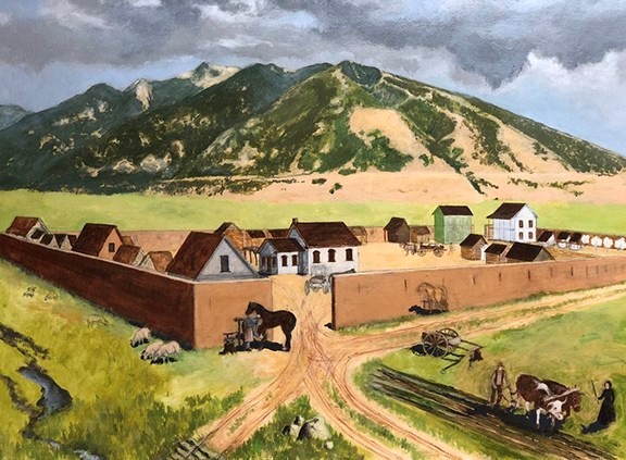
Photo Credit: Rendering of the Old Draper Fort in Pioneer Times (1850’s) – Draper Historical Society

Historical Marker Text:

ERECTED JANUARY 1940

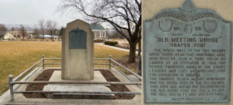
“OLD MEETING HOUSE” DRAPER FORT

            THE NORTH WALL OF THE “OLD MEETING HOUSE’ STOOD NEAR THIS MONUMENT. HERE (1861-1869) DR. JOHN R. PARK BEGAN HIS CAREER AS AN EDUCATOR IN UTAH. THIS SCHOOL PRODUCED MANY OF THE STATES LEADERS AND LEFT AN INDENIBLE LOVE FOR THE EDUCATION IN DRAPER.

THE GRANITE BLOCK IN THIS MONUMENT WAS THE SOUTH STEP OF THE OLD CHURCH. THIS SPOT WAS WITHIN THE ENCLOSURE OF THE OLD ADOBE FORT 184 YDS. X 113 YDS. THE WALL WAS 14 FT. HIGH AND 3 FT. THICK.

EBENEZER BROWN CAMP

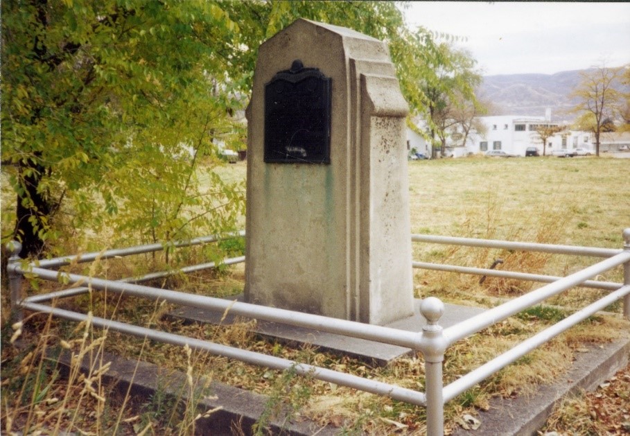
Historical Marker View in Draper Historical Park
Photo Credit: Draper Historical Park (1990) – JacobBarlow.com
Draper Historical Park (2020) – Home of the Old Meeting House – Draper Fort Marker

Extended Research:

The marker for the Old Meeting House Draper Fort commemorates two important pieces of history in Utah and the city of Draper: the Draper Fort and the Old Meetinghouse that sat inside the fort. The marker is located on the north side of Draper Historic Park.

Settlers moved to the south east end of the Salt Lake Valley into an area called South Willow Creek in 1850. The area grew rapidly and by the end of 1852, 20 families called South Willow Creek home.[1] In 1854, the establishment of the first post office brought a name change to the town. The area came to be known as Draperville, in honor of William Draper JR, who was a prominent member of the Church of Jesus Christ of Latter-day Saints (LDS). In 1877, the town shortened the name to Draper.[2]

On 10 April 1854, Brigham Young addressed the followers of his church: “from hence forth, let one and all go forth with one accord and build their forts, wall in their cities and villages, herd and guard their cattle and other property and keep their guns and ammunition in good order and convenience, ready for instant use.”[3] Skirmishes erupted from Sanpete to Salt Lake Counties between Native Americans under Ute Chief Walkara and settlers. Walkara had become upset by Mormon efforts to stifle Indian slave trading and by the increased intrusion of settlers into traditional Native American hunting grounds.[4] This broader violence shaped the first Mormon settlement in the area that became Draper.

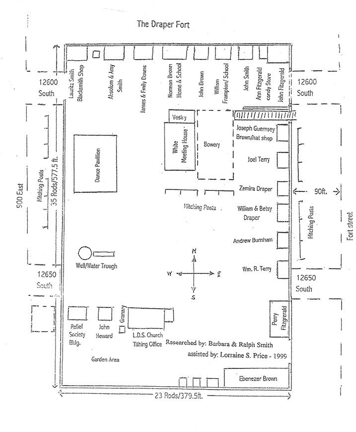
Ebenezer Brown and his family were the first settlers to arrive in “South Willow Creek” in 1849. Ebenezer’s homestead was 160 acres. Because of the Native threat, and at Brigham Young’s directive, Ebenezer donated 5 acres of his property to build a fort where members of the community could gather and feel safe. In late 1854, the fort construction began for protection to those pioneers homesteading in the area. It took two years to build walls of adobe brick and clay around the fort that measured 23 rods east to west and 35 rods north to south. A Rod is an old English measure of distance equal to 16.5 feet (5.029 meters). The walls were eight feet high and one foot wide with look-out slots every fourteen feet. All homes faced the center of the fort.[5]

Photo Credit: Ebenezer Brown – Courtesy of the Draper Historical Society

The Draper Historical Society has researched the fort extensively and created a map of houses and shop locations inside the fort.

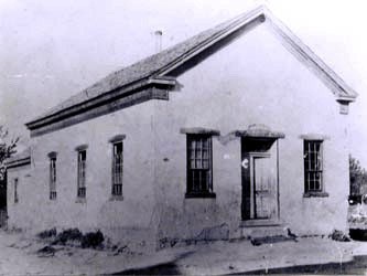
The entrance to the fort was a dirt road through a wide opening in the northwest corner of the fort and in front of Lauritz Smith’s blacksmith shop. A garden area was at the southwest end of the fort. It included a small orchard of apple and peach trees, planted by William Terry with seeds he carried across the plains from Rhode Island. John Fitzgerald’s home was built on the northeast corner of the fort. John’s mother, Ann, had a candy store attached to the home. The first house built was Ebenezer’s, and then running west along the south wall were three other small homes. Perry Fitzgerald’s two-story home was built on the east wall and to the west was the LDS Church tithing office and granary and the Relief Society Hall. Ebenezer’s son, Norman Brown, built an adobe brick house. This house also served as Draper’s first schoolhouse. From its beginning, Draper showed a special interest in education. Schooling began right away with Betsy Draper, wife of William Draper, as Draper's first teacher. Town leaders were always on the lookout for qualified teachers and paid them out of their own pockets. By the year 1855 the population of the community had grown to 222 people. Up until then church, school and public meetings were held in homes. More space was needed, so in 1860 the vestry was built across from the Norman Brown home. In 1863 the main hall was added to the vestry, and from that time the building was known as "The Old White Meetinghouse".[6]

The fort was an essential part of the community and provided the settlers with a sense of security and comfort during the early history of Draper.[7] Due to the increased tensions with the Native Americans and the settlers, many people tended to things outside the fort during the day such as their own homes, cows, sheep and other livestock. At night they returned to the fort to be safe from home raids. The temporary homes inside the fort were for sleeping only. They were very small with some being just one room. Some were no larger than a wagon box. Difficulties with Native American tribes lessened by the late 1850’s. The fort was never attacked, and families began returning to their homes. Ebenezer Brown deeded the “center area” of the fort to the community.[8] The fort was disbanded around 1864 and the fort walls were gradually dismantled. The Old White Meetinghouse and some of the original homes remained and in 1892 the Draper First Ward Church was built on the property.[9]

Draper Fort as researched by Draper Historical Society

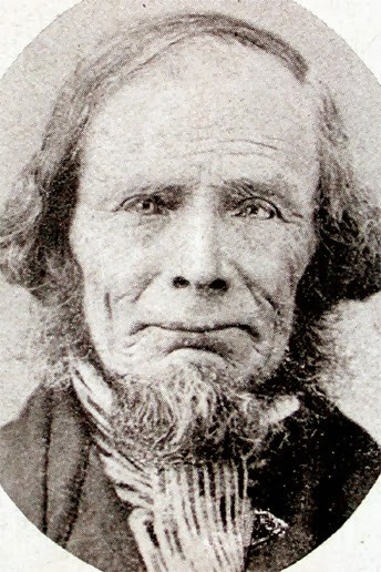
The Draper Fort housed one of the town’s most essential buildings, the schoolhouse. Settlers of Draper built the first schoolhouse in 1852 on the north wall of the Draper Fort.[10] The schoolhouse became home to early educator, John Rocky Park. The schoolhouse also served as a public and spiritual gathering place for nearly twenty years after construction.[11] Park was an integral figure in education in not just Utah but in the expansion of the western territories of the United States. Park was at one time, president of the University of Deseret, that was later renamed the University of Utah. In 1895, Park was elected as Utah Superintendent of Education.[12]

Photo Credit: Old White Meetinghouse – Courtesy of the Draper Historical Society

Draper became known as the “Cradle of Education” in the West.[13] The Draper curriculum of John Rocky Park became known for its excellence at all grade levels. Park gained notoriety for his school and what was being taught inside its walls. With Trustee funding, Dr. Park, provided blackboards, maps and charts.[14] Brigham Young even wanted to build the University in Draper but disputes over land caused the site to move locations.[15] A student of those days reminisced: “The [school’s] walls were soon covered with maps and charts illustrative of all departments of knowledge. Models and globes rested on the broad window seats. A tellurion, a miniature illustration of the planetary system, was provided . . .”[16] Author Ralph Chamberlain found evidence of the renowned success of John R. Park’s school in Draper: “From a little country village, with a population of about 300, secluded in a corner of the Salt Lake Valley, in a brief period of five years that still stands out as its golden age, went forth a surprising number of men who later achieved high success; and in that village developed a spirit and movement that in time spread beyond it and inaugurated in Utah an educational regeneration. Never was the potential power of the good teacher more strikingly demonstrated.”[17]

Photo Credit: Dr John R Park – Courtesy of the Draper Historical Society

In January 1940, the Ebenezer Brown Camp of the Daughters of the Utah Pioneers erected a monument on the original site of the old meetinghouse. The granite block in the monument was the south step of the old church.[18]

For Further Reference:

Primary Sources:

James Herman Tegan, “Pioneer Personal History” Survey, The Works Progress Administration (Utah Section) Biographical Sketches, 1939, https://collections.lib.utah.edu/ark:/87278/s6pv8qj7

John Hamilton Morgan, “Scans of miscellaneous papers related to John Hamilton Morgan”, Digitized by J. Willard Marriott Library, University of Utah, 1951-1952, https:/collections.lib.utah.edu/ark:/87278/s6dn4xjn

John R. Park papers, MS 0242, Box [ ]. Special Collections and Archives. University of Utah, J. Willard Marriott. Salt Lake City, Utah.

Elisabeth Boulter Enniss, Journal 1874 – 1879, Draper Historical Society Museum, Draper, Utah

Secondary Sources:

PETERSON, CHARLES S. “A New Community: Mormon Teachers and the Separation of Church and State in Utah’s Territorial Schools.” Utah Historical Quarterly 48, no. 3 (Summer 1980): 293-312.

Willey, Darrell S. “Utah’s Frontier Architect of Social Destiny: John R. Park.” Peabody Journal of Education 38, no. 2 (1960): 100-06.

Noel Ennis, True to the Faith: The Life of W.B. Enniss 1857-1947, (Pioneer Books, 2004)

Draper Historical Society, “The History of Draper, Utah, vol. 2: Sivogah to Draper City 1849-1977”, (Agreka Books 2001)

Draper Historic Preservation Commission, “Draper History,” Draper Utah’s Historic Buildings, May 19, 2017, accessed April 2, 2020

Draper Historic Preservation Commission, “Draper Park School,” Places that Matter – Draper, Utah, May 2014, accessed April 2, 2020

University of Utah, and Ralph V. Chamberlin. 1949. Memories of John Rockey Park

Footnotes:

[1] Draper Historical Society, “The History of Draper, Utah, vol. 2: Sivogah to Draper City 1849-1977”, (Agreka Books 2001)

[2] Noel Ennis, True to the Faith: The Life of W.B. Enniss 1857-1947, (Pioneer Books, 2004)

[3] Draper Historic Preservation Commission, “Draper History,” Draper Utah’s Historic Buildings, May 19, 2017, accessed April 2, 2020

[4] University of Utah, and Ralph V. Chamberlin. 1949. Memories of John Rockey Park

[5] Draper Historic Preservation Commission, “Draper History,” Draper Utah’s Historic Buildings, May 19, 2017, accessed April 2, 2020

[6] Draper Historic Preservation Commission, “Draper History,” Draper Utah’s Historic Buildings, May 19, 2017, accessed April 2, 2020

[7] Draper Historic Preservation Commission, “Draper Park School,” Places that Matter – Draper, Utah, May 2014, accessed April 2, 2020

[8] Draper Historic Preservation Commission, “Draper History,” Draper Utah’s Historic Buildings, May 19, 2017, accessed April 2, 2020

[9] Draper Historical Society, “The History of Draper, Utah, vol. 2: Sivogah to Draper City 1849-1977”, (Agreka Books 2001)

[10] John R. Park papers, MS 0242, Box [ ]. Special Collections and Archives. University of Utah, J. Willard Marriott. Salt Lake City, Utah.

[11] John R. Park papers, MS 0242, Box [ ]. Special Collections and Archives. University of Utah, J. Willard Marriott. Salt Lake City, Utah.

[12] University of Utah, and Ralph V. Chamberlin. 1949. Memories of John Rockey Park

[13] University of Utah, and Ralph V. Chamberlin. 1949. Memories of John Rockey Park

[14] PETERSON, CHARLES S. “A New Community: Mormon Teachers and the Separation of Church and State in Utah’s Territorial Schools.” Utah Historical Quarterly 48, no. 3 (Summer 1980): 293-312.

[15] Draper Historic Preservation Commission, “Draper Park School,” Places that Matter – Draper, Utah, May 2014, accessed April 2, 2020

[16] Elisabeth Boulter Enniss, Journal 1874 – 1879, Draper Historical Society Museum, Draper, Utah

[17] University of Utah, and Ralph V. Chamberlin. 1949. Memories of John Rockey Park

[18] Draper Historic Preservation Commission, “Draper History,” Draper Utah’s Historic Buildings, May 19, 2017, accessed April 2, 2020

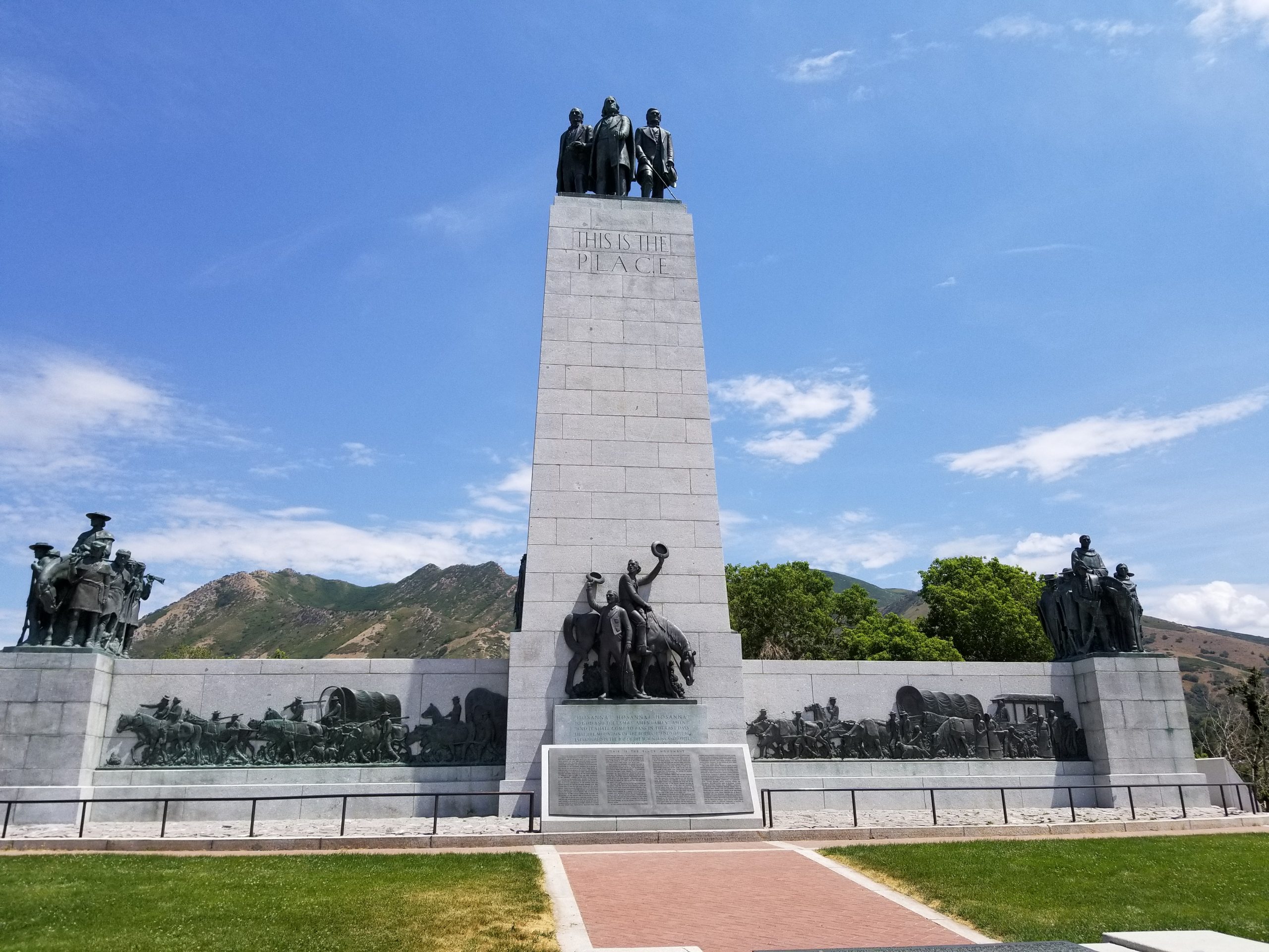
Old This is the Place Monument

Write up by: Kauriana Kendall

Placed by: Mutual Improvement Association of the Church of Jesus Christ of Latter-day Saints

GPS coordinates: 40.75319429362746, -111.81347150355577

Historical marker text (1):

THIS IS THE PLACE

BRIGHAM YOUNG

JULY 24 1847

Historical marker text (2):

THIS IS THE PLACE: A Rededication

In commemoration of a most significant historical event, this monument was first dedicated July 25, 1921. It marked the arrival in this valley of the Mormon Pioneers 74 years earlier, and more specifically, the moment when President Brigham Young rose from his sick-bed in Wilford Woodruff’s carriage and proclaimed to all the world: “This is the Place.”

Even in 1921, there was much disputation as to the exact location of the noted event. This monument was located here as the definitive answer as to where the event occurred. This answer came primarily from two speakers, very different in their presentations, but equally convincing in their conclusion.

The first speaker was 83-year-old W.W. Riter. As a lad of 9 years, he and his parents had followed Brigham Young to this valley. W.W. Riter was the living authority for the correct placing of the monument. In his early years, Wilford Woodruff had taken him to the spot and stated that this is exactly where Brigham Young had uttered those important words.

The second speaker was Brigham H. Roberts, aged 64, a prolific historian, theologian, congressman, eminent scholar, and a member of the Quorum of the Seventy. He said, “There has been much discussion as to whether this particular spot just outside the mouth of Emigration Canyon was really the place.” Then, quoting often from the journal of Wilford Woodruff, Mr. Roberts proved conclusively that there can be no doubt that the spot now marked by this concrete monument is very near to the actual place. In fact, speaking of the question, he remarked: “Seventy four years ago yesterday an incident occurred on or near the spot where we now stand that is destined to live in the memory of men through the ages to come.”

The above comments have been taken substantially from three articles published in the Salt Lake Tribune and three in the Desert News of the period. The comments came before and after the event.

The project of refurbishing the monument jointly undertaken by the Mills Chapter of the Sons of Utah Pioneers and Zachary Mahoney, a Scout who used his skill and wisdom to make his Eagle Project not only memorable but lasting.

Site No. 129

July 21, 2007

Rededicated by Elder Boyd K. Packer

Historical marker text (3):

THIS IS THE PLACE MONUMENTS

The first marker to commemorate the arrival of the Mormon pioneers into the Salt Lake Valley was a wooden cross. The eight foot post carried the name “Brigham Young.” The crosspiece said “This is the place.” In 1921, the wooden cross was replaced with the obelisk monument. This spot is where Brigham Young, in viewing the valley, made the statement, “This is the right place. Drive on.”

Extended research:

The Church of Jesus Christ of Latter-day Saints was a relatively new religious movement in 1847, but the persecution its members faced up to that point was great. They were driven out of three states, faced an extermination order in one, and had received little support from local and federal governments. Their first leader, Joseph Smith, was murdered, and the process of setting up new leadership led to major dissension within the Church. The new leader, Brigham Young, initiated an effort to move his followers outside of America (to what would later be known as Utah) to avoid more persecution and government restrictions on their worship. Starting in 1846, members of the Church began making the trek west in wagon companies and, later, some handcart companies.

Brigham Young and his wagon company arrived in the Salt Lake Valley on July 24 1847, where Young probably said something along the lines of, “this is the right place. Drive on.” According to his journal, at the top of Big Mountain, Brigham Young saw “the Spirit of Light…over the valley” and knew this was the spot the settlers were looking for. However, he made no note of the phrase “this is the place.”[1] Historians have debated whether Young actually said these words that became a monument and the name of a state park. Despite the certainty implied by the “This is the Place” monuments, there is no documentation of exactly what Brigham Young said that day. Pioneer Levi Jackman’s journal is perhaps as close as historians will get to Young’s actual words that day. Four days after Young’s arrival, Jackman paraphrased Brigham Young during a meeting called in order to decide “whear the city should be built.” As Jackman recorded it, “After a number had spoken on the subject a voat was calld for unanimosiley aggread that this was the spot. After that Pres Young said tha he knew that this is the place. he knew it as soon as he came in sight of it and he has seen this vearey spot before.”[2]

Wilford Woodruff, whose wagon the ill Young was riding in, made no comment on the words of his leader the day they entered the Salt Lake Valley; however, he is the one who eventually said the famous phrase during a Pioneer Day speech given in 1880—thirty-three years after the arrival of the wagon company and three years after Brigham Young’s death—that is so often repeated today. Here, Woodruff attributed to Young the words “This is the right place. Drive on.” Then, in 1888, Woodruff repeated the story, but quoted Young as saying “Drive on down into the valley; this is our abiding place.” Finally, in 1897, Woodruff told the story in another speech, this time quoting “That will do, drive on; this is the place.”[3] Clearly, there is no way to know exactly what Young said that day, but the catchy line written on the monument and advertised by the This is the Place Heritage Park continues to evoke feelings of pride from Utahns, especially every July 24th when Pioneer Day celebrations rival those of the Fourth of July.

Also despite the certainty of the text contained in the old monument’s longest plaque, historians do not all agree that the cement obelisk actually stands on the spot where Brigham Young looked out over the valley and declared that they had found the right place to settle. Historian W. Randall Dixon provides a description of the trails taken by the various groups of pioneers based on several journal entries. He explains that the Mormon Battalion took a vastly different route than Brigham Young’s wagon company into the Salt Lake Valley when they arrived five days later on July 29. Since this was the most direct trail to Emigration Road, where emigrants finally ended their trek and camped until finding a home, it is likely the one most of the later wagon companies used. Dixon concludes that “Most of the newcomers probably assumed that their trail was that which had been followed by their predecessors on July 22 and July 24. This may explain some of the later confusion on the matter of trails.”[4] W.W. Riter, named on the plaque as the “living authority for the correct placing of the monument,” was one such case, arriving in the valley 10 weeks after Brigham Young, according to his speech at the dedication of the monument. In this speech, he refuted claims that the first pioneers climbed over a hogback, but does not give any possible explanation for the “steep pitch” both Howard Egan and Heber C. Kimball, members of Young’s wagon company, mentioned ascending. Riter also claimed that he “crossed this same spot,”[5] meaning the location of the cement monument, probably not realizing that he would not have followed the same trail as Young, since a shorter, better blazed trail had been carved out for him by then. Therefore, even if he did cross that spot, it does nothing to prove that Young ever did.

Brigham H. Roberts, the second witness to the correct location listed on the monument plaque, is quoted a little misleadingly. In the speech he gave at the dedication of the old monument, he does in fact say that “an incident occurred on or near the spot where we now stand,” and he did quote Wilford Woodruff extensively, as the plaque says. However, his quote that “There has been much discussion as to whether this particular spot just outside the mouth of Emigration Canyon was really the place” is not from the same speech as the plaque suggests. In the dedication speech, Roberts was not at all concerned with the correct placement of the monument, but rather focused on the emotional aspects of the pioneers’ journey across the country and the mission of the saints in the valley.[6] Records such as the old This is the Place monument plaques and even the official history of The Church of Jesus Christ of Latter-day Saints published by the Church which present the location and words of Brigham Young on that historic day as certain facts show that many people, including historians, have accepted half-explained truths and uncertain quotes in order to keep alive the idealized image of Brigham Young rising from his sick bed to announce “this is the right place; drive on.” The truth is that we do not know the exact spot where Young first saw the valley, nor do we know the words he said when he saw it. There are several other testimonies that suggest that the Old This is the Place Monument is placed accurately to the north of Emigration Creek, and there are many other historians who are certain Woodruff’s wagon stopped to the south of the same creek. While we can assume that the famous event took place somewhere around the mouth of Emigration Canyon, we must accept that the This is the Place monuments are more about commemorating a day of new beginning rather than giving us a perfect historical record that does not exist.

Though the arrival of the pioneers who were members of the Church of Jesus Christ of Latter-day Saints in the Salt Lake Valley was important for a people trying to leave a country where they had faced persecution at every turn, they themselves then became the persecutors and the beginning of an end for the Native Americans inhabiting the same land. Brigham Young, consistent with his personality, wanted to be kind to the Native Americans and convert them to his religion, but was also wary and ready to mete out justice to any he believed deserved it. He said:

They [the Indians] are of the House of Israel, and the time has come for the Lord to favor Zion, and redeem Israel. We are here in the mountains, with these Lamanites for our neighbors, and I hesitate not to say, if this people possessed the faith they ought to have, the Lord Almighty would never suffer any of the sons of Jacob to injure them in the least; no never. But I am suspicious that this people do not possess the faith they should have, therefore I calculate to carry with me proper weapons of defence, that if a man should aim a blow at my person to take away my life, before he is aware, he himself is numbered with the dead.[7]

Even when attempting kindness, the Mormon pioneers inevitably changed the lives of the natives by settling on valuable lands and trying to end the slave trade. Then many white settlers grew tired of kindness, leading to attacks on Native Americans for stealing, which culminated in events like the Walker War and the Black Hawk War. All of these tensions eventually ended to the satisfaction of the settlers: the natives were federally ordered and violently rounded up onto reservations which by 1900 represented four percent of the land native peoples controlled before the Mormons arrived in 1847. In addition, between 1847 and 1900, the natives suffered an estimated 90% population decrease.[8] While the larger “This is the Place Monument,” placed in 1947, does a better job at commemorating more groups of people involved in the history of Utah, the small 1921 obelisk focuses only on the members of the Church of Jesus Christ of Latter-day Saints. While Utahns should be welcome to celebrate their heritage and the hardships their own ancestors endured, we would do well to remember that a home gained for one group meant a home lost for another.

[1] Jeffery Carlstrom and Cynthia Furse, The History of Emigration Canyon: Gateway to Salt Lake Valley (Logan: Utah State University Press, 2003), 32.

[2] Levi Jackman, Levi Jackman Journal, 1847 March-1849 April, microfilm, MS 138, Church History Library, Church of Jesus Christ of Latter-day Saints, Salt Lake City, Utah.

[3] Jeffrey Carlstrom and Cynthia Furse, The History of Emigration Canyon: Gateway to Salt Lake Valley (Logan: Utah State University Press, 2003), 32-33.

[4] W. Randall Dixon, “From Emigration Canyon to City Creek: Pioneer Trail and Campsites in the Salt Lake Valley in 1847,” Utah Historical Quarterly 65, no. 2 (1997): 163, accessed February 24, 2020, https://issuu.com/utah10/docs/uhq_volume65_1997_number2.

[5] W.W. Riter, “Correct Placing of the Monument, Pioneer View,” Improvement Era 24, no. 11 (1921): 969-973, accessed February 24, 2020, https://archive.org/details/improvementera24011unse/page/962/mode/2up/search/mouth+of+emigration+canyon.

[6] B.H. Roberts, “Monument at Pioneer View,” Improvement Era 24, no. 11 (1921): 963, accessed February 24, 2020, https://archive.org/details/improvementera24011unse/page/962/mode/2up/search/mouth+of+emigration+canyon.

[7] Brigham Young, Journal of Discourses Vol. 1, (Liverpool : F.D. and S.W. Richards, 1854), https://contentdm.lib.byu.edu/digital/collection/JournalOfDiscourses3/id/1805.

[8] Forrest S. Cuch, ed., A History of Utah’s American Indians (Salt Lake City: Utah State Division of Indian Affairs/Utah State Division of History, 2003).

For further reference:

Primary Sources:

Jackman, Levi. Levi Jackman journal, 1847 March-1849 April. Microfilm, MS 138. Church History Library.. Church of Jesus Christ of Latter-day Saints. Salt Lake City, Utah.

Roberts, B.H. “Monument at Pioneer View.” Improvement Era 24, no. 11 (1921): 957-1049. Accessed February 24, 2020. https://archive.org/details/improvementera24011unse/page/962/mode/2up/search/mouth+of+emigration+canyon.

Riter, W.W. “Correct Placing of the Monument, Pioneer View.” Improvement Era 24, no. 11 (1921): 957-1049. Accessed February 24, 2020. https://archive.org/details/improvementera24011unse/page/962/mode/2up/search/mouth+of+emigration+canyon.

Young, Brigham, Journal of Discourses Vol. 1. Liverpool : F.D. and S.W. Richards, 1854. https://contentdm.lib.byu.edu/digital/collection/JournalOfDiscourses3/id/1805.

Secondary Sources:

Carlstrom, Jeffrey and Cynthia Furse, The History of Emigration Canyon: Gateway to Salt Lake Valley. Salt Lake City: Utah State Division of Indian Affairs/Utah State Division of History, 2003.

Cuch, Forrest S., ed. A History of Utah’s American Indians. Utah State University, University Libraries, 2003.

Dixon, W. Randall. “From Emigration Canyon to City Creek: Pioneer Trail and Campsites in the Salt Lake Valley in 1847.” Utah Historical Quarterly 65, no. 2 (1997): 100-195. Accessed February 24, 2020. https://issuu.com/utah10/docs/uhq_volume65_1997_number2.

Hales, Scott A., David C. Nielsen, Angela Hallstrom, Dallin T. Morrow, and James Goldberg. Saints: The Story of the Church of Jesus Christ of Latter-Day Saints. Edited by Matthew J. Grow, Jed L. Woodworth, Scott A. Hales, and Lisa Olsen Tait. Vol. 2. Salt Lake City, Utah: The Church of Jesus Christ of Latter-day Saints, 2020.
Kennedy Ditch

Published / by Jaclyn Foster / Leave a Comment

write-up by Jaclyn Foster

Placed By: Daughters of the Utah Pioneers, no. 96

GPS Coordinates: N 40º44’021” W 111º51’554”

Historical Marker Text:

Photo via Waymarking.com

Daughters of Utah Pioneers
No. 96
Erected 1947

THE KENNEDY DITCH

The Kennedy Ditch was an early pioneer irrigation canal taken out of Parley’s Canyon stream near 17th East. The construction was achieved as a co-operative work project, and the new channel named after its first Water Master, Charles Kennedy, a Utah pioneer of 1848. The area thus brought under cultivation, covered 864 acres of small farm lands extending west of 13th East from near 21st South northward to 9th South, including this spot on Emerson Avenue.
Emerson Camp    Salt Lake County

Photo via Waymarking.com

Extended Research:

Early European explorers of Utah referred to the region as the “Great American Desert.” Most explorers believed the region was unsuitable for settlement, despite the fact that it had sustained Ute, Goshute, Paiute, and other tribes for thousands of years. In 1843, however, John Fremont published a report that suggested the western base of the Wasatch Mountains could be colonized by creating an irrigation system from mountain streams.1

When the Mormon pioneers arrived in the Salt Lake Valley in 1847, creating a planned system of irrigation canals was one of their first priorities. Mormon leader Brigham Young sent an advance party of able-bodied men to the Salt Lake Valley in July of 1847, with the goal of planting crops and building shelters before winter. This advance party laid out city blocks, farmland, and irrigation canals. Subsequent waves of Mormon pioneers expanded upon this planned, communal settlement pattern. City lots were divided into wards, which were supervised by bishops. These bishops oversaw the process of creating irrigation ditches for each ward.

Charles Kennedy. Image via churchofjesuschrist.org.

Communal ownership of water was an important innovation for the Mormon pioneers. In the East, laws commonly mandated that water could not be taken from streams unless it was returned without a reduction in volume. This was clearly impossible in the Salt Lake Valley’s semi-arid environment. Instead, Brigham Young declared that there would be “no private ownership” of water; dams and ditches were constructed by ward communities, rights to use the water depended on whether the land was being cultivated, and public authorities were appointed to supervise and apportion water use. This public authority was called the Water Master, who was appointed by the high council. One Water Master oversaw multiple wards.2

Charles Kennedy was the Water Master of the Kennedy Ditch and surrounding area. He joined the Church of Jesus Christ of Latter-day Saints in Nauvoo, Illinois in 1844 and was endowed in 1846. During the migration to Utah, Kennedy served as Commissary for 50 wagons, which meant he was in charge of distributing goods. He was part of the 1848 Brigham Young Company and settled in the Sugar House Ward, where he was appointed Water Master. Sometime between 1860 and 1867, Kennedy left the Mormon Church and moved to Missouri with two of his wives. He died in 1890.3

The missing historical marker

The Kennedy Ditch no longer exists. The current marker at the site of the Kennedy Ditch is missing. However, an online community called Waymarkers, where users log their visits to local landmarkers as a type of real-life scavenger hunt, provides clues about when this marker disappeared. Waymarkers documented the marker up until June 1, 2011; the next entry, on December 12, 2013, notes that the marker had been removed.4 It may be stored in the LDS chapel that currently occupies the site, but its whereabouts are uncertain.

For Future Reference:

Primary Sources

“Charles Kennedy,” Mormon Pioneer Overland Travel 1847-1868, churchofjesuschrist.org

“Charles Kennedy,” Missouri Death Records 1834-1910, 1890.

Secondary Sources

Arrington, Leonard. Great Basin Kingdom: Economic History of the Latter-day Saints 1830-1900 (Harvard University Press, 1958).
Barlow, Jacob. “The Kennedy Ditch (Missing),” Waymarking.com (September 11, 2007).

Givens, Robert. “Life of Charles Kennedy,” Family Search (2012).

Footnotes:

1. Leonard Arrington, Great Basin Kingdom: Economic History of the Latter-day Saints 1830-1900 (Harvard University Press, 1958), 44.

2. Arrington, 45-53.

3. “Charles Kennedy,” Mormon Pioneer Overland Travel 1847-1868, churchofjesuschrist.org; Robert Givens, “Life of Charles Kennedy,” Family Search (2012).

4. Jacob Barlow, “The Kennedy Ditch (Missing),” Waymarking.com (September 11, 2007).

Cottonwood Paper Mill

Published / by Jaclyn Foster / 3 Comments on Cottonwood Paper Mill

write-up by Jaclyn Foster

Placed By: Daughters of the Utah Pioneers, no. 326

GPS Coordinates: N 40º37’603” W 111º48’000”

Historical Marker Text:

Daughters of Utah Pioneers
No. 326
Erected 1966
COTTONWOOD PAPER MILL

In 1880 the Deseret News Corporation purchased a 28-acre millsite including water rights. With Henry Grow, architect and builder, the $150,000 structure, made of granite from nearby quarries with mortar of clay and stone grindings, took three years to erect. The 1860 paper machine from Sugarhouse Mill and some new machinery was installed; a 1500-ft. race brought water through the penstock to encased turbines. The plant could yield 5 tons of paper a day. Chas. J. Lambert, manager, sold to Granite Paper Mills Co. 1892; destroyed by fire 1893; restored 1927 as a recreational center.
Central Company

Extended Research:

The first newspaper established in the Mountain West, the Deseret News, began publication in June of 1850. In order to reduce production costs, LDS leader Brigham Young appointed Thomas Howard, a paper maker from England, to construct a paper mill in Sugar House. The machinery for this mill was updated several times, with thrifty pioneers exchanging parts between beet sugar, iron working, and paper industries. In 1883, under the direction of Henry Grow, Deseret News Company received new paper machinery, and built Cottonwood Paper Mill to house the old machinery for use as a spare. The new mill was built using discarded granite from the construction of the Salt Lake Temple.

After the completion of the railroad, paper became cheaper to import, and the Deseret News sold Cottonwood Paper Mill to Granite Mills Paper Company in 1892. The mill was destroyed by fire in 1893.1

C. R. Savage. Deseret Paper Mill, Mouth of Cottonwood Canon Utah. L. Tom Perry Special Collections

Paper mills produce paper from waste cellulose fibers. In this case, the mill used cotton and linen rags. These rags were cooked and beaten to suspend the cellulose fibers in water. The fibers were collected on framed screens dipped in the water, and the water was removed by stacking frames between felt sheets. After the paper was dry, they were briefly soaked in gelatin or starch solutions, and dried again. This last step was known as “sizing” and prevented ink from feathering.2

Successful operation of the mill was a community endeavor. The mill required a constant supply of rags, which were collected by the Deseret News, public works programs, and church initiatives. In 1861, George Goddard was called on a three-year mission with the sole task of collecting rags for the mill. The calling “was a severe blow to [his] native pride,” but Goddard accepted the assignment. His rag collecting took him from Franklin, Idaho to Sanpete County, and involved preaching sermons on Sunday about rag collection. Goddard collected over 100,000 pounds of rags for the mill. The Women’s Relief Society took over rag collection in 1867 and organized regular rag drives.3

Following its destruction by fire in 1893, the mill remained unused until it was rebuilt in 1927 by J. B. Walker, a private citizen. The mill was transformed into an open-air dance hall, the Old Mill Club, and played a significant role in the local social scene. The club’s use was disrupted by World War II, when rationing increased food prices and military enrollment made mixed-sex activities, such as dancing, impractical. Following the end of the war, the social scene had shifted to drive-in movies, and the Old Mill Club never regained its former prominence, although it had rebranded itself as a “discotheque” by 1970.4 It has remained in the hands of the Walker family, with J. B. Walker’s grandson-in-law managing the property since 1987. The mill was condemned by Cottonwood Heights in 2005 due to earthquake building codes.5

Since its condemnation, the mill has been the target of repeated vandalism and theft. In 2011, thieves stole over $20,000 of copper wiring, and the mill’s historical marker was removed by the owner after he came upon thieves who had cut three of the plaque’s four bolts in order to steal it.6 Today, the mill is a study in contrasts. The crumbling, graffiti-laden building sits just up the road from a private gated community which bears its name and likeness. Residents tell ghost stories about the mill, and when the city of Cottonwood Heights commissioned a book on the community’s history, the mill graced the book’s cover. The mill’s owner envisions a future where the mill is rebuilt and used as an art gallery and dance hall.

For Future Reference:

Primary Sources

“The Paper Mill,” Deseret News, April 8 1893.

Cabrero, Alex. “Thieves make away with $20,000 of copper wiring from Old Mill,” KSL News, November 17, 2011.

Secondary Sources

Arrington, Leonard. Great Basin Kingdom: Economic History of the Latter-Day Saints 1830-1900. (Lincoln: University of Nebraska Press, 1966).

Roberts, Allen D. City Between the Canyons: A History of Cottonwood Heights, 1849-1953. Available at Cottonwood Heights City Hall.

Saunders, Richard. “‘Rags! Rags! Rags!!!’: Beginnings of the Paper Industry in the Salt Lake Valley, 1849-1858.” Utah Historical Quarterly 62(1), 1994.

Smith, Melvin T. “National Register of Historic Places Nomination: Granite Paper Mill.” National Register of Historic Places Inventory, National Parks Service, (December 10, 1970).

Footnotes:

1. Melvin T. Smith, “National Register of Historic Places Nomination: Granite Paper Mill.” National Register of Historic Places Inventory, National Parks Service, (December 10, 1970).

2. Richard Saunders, “‘Rags! Rags! Rags!!!’: Beginnings of the Paper Industry in the Salt Lake Valley, 1849-1858.” Utah Historical Quarterly 62(1), 1994

3. Leonard Arrington, Great Basin Kingdom: Economic History of the Latter-Day Saints 1830-1900. (Lincoln: University of Nebraska Press, 1966), 114-116.

4. Melvin Smith, National Register of Historic Places

5. Doug Shelby, interviewed by Jaclyn Foster at Cottonwood Heights residence, February 3, 2019.

6. Alex Cabrero, “Thieves make away with $20,000 of copper wiring from Old Mill,” KSL News, November 17, 2011.

Wasatch Springs Plunge

Published / by Juli Huddleston / 7 Comments on Wasatch Springs Plunge

Write-up by Julia Huddleston

Placed By: Division of State History. The building is on the national register of historic places

GPS: 40.789, -111.900

Historical Marker Text:

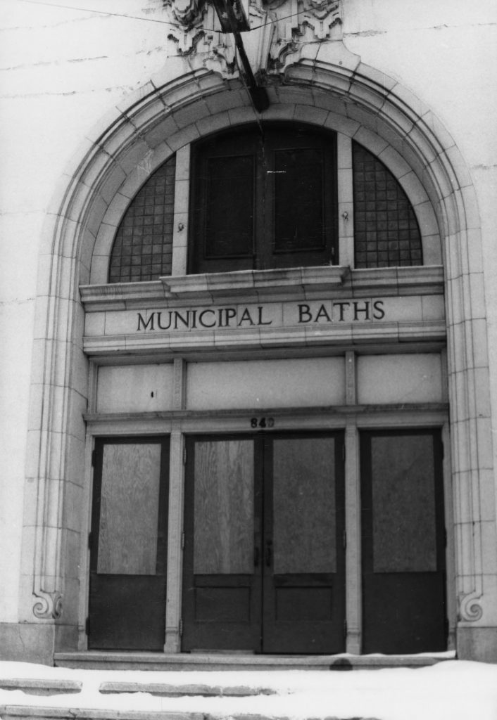
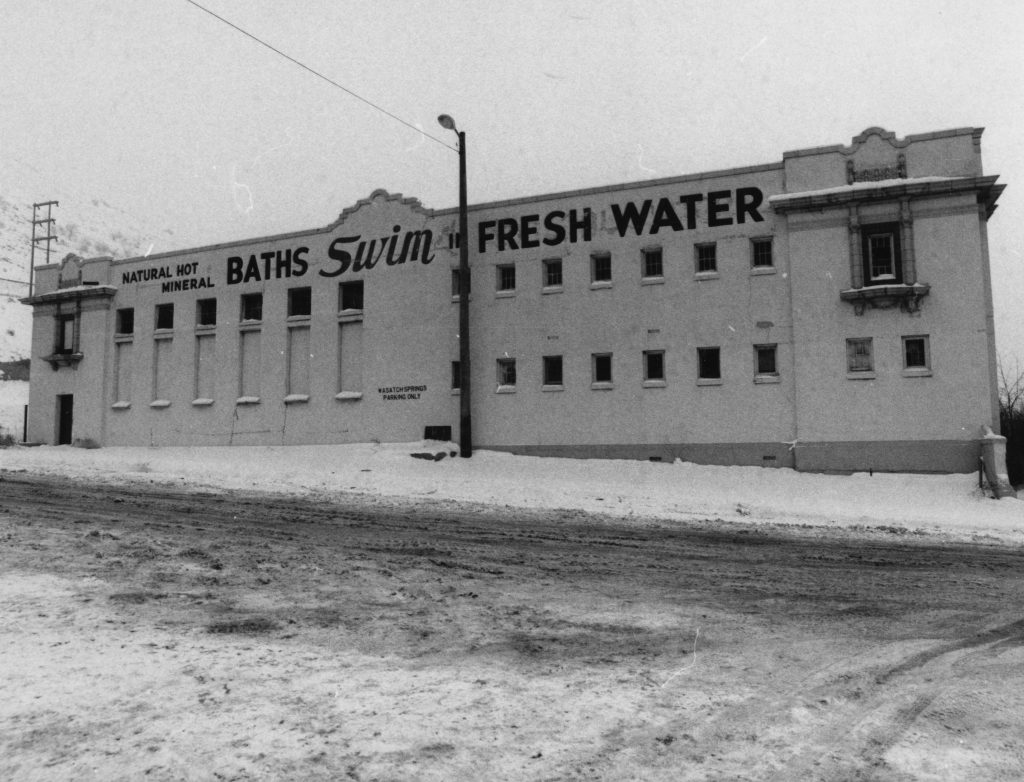
Built near several warm springs, the Wasatch Springs Plunge is significant for its Mission style architecture and as an early municipal recreational facility. The warm springs along this portion of the Wasatch Fault were used by Native Americans even before the arrival of the Mormon pioneers who quickly developed the springs and constructed numerous bathing facilities, praising the warm sulphurous [sic] water for its curative and rejuvenating qualities. This substantial masonry building was built by Salt Lake City in 1921 and replaced earlier frame buildings.

Designed by the noted local architecture firm of Cannon and Fetzer, the building exemplifies the Mission Style. The stuccoed walls, red tile roofs, curvilinear parapets, arched openings and arcades are characteristic of the Mission style which emanated from California at the end of the nineteenth century and was based on the old Catholic missions.

Due to problems with the water, deterioration of the structure, construction of newer pools and changes in demographics, the facility fell into disuse in the 1970s and was closed. It was later rehabilitated and reopened in 1983 as The Children’s Museum of Utah.

Marker placed in 1993.

Extended Research:

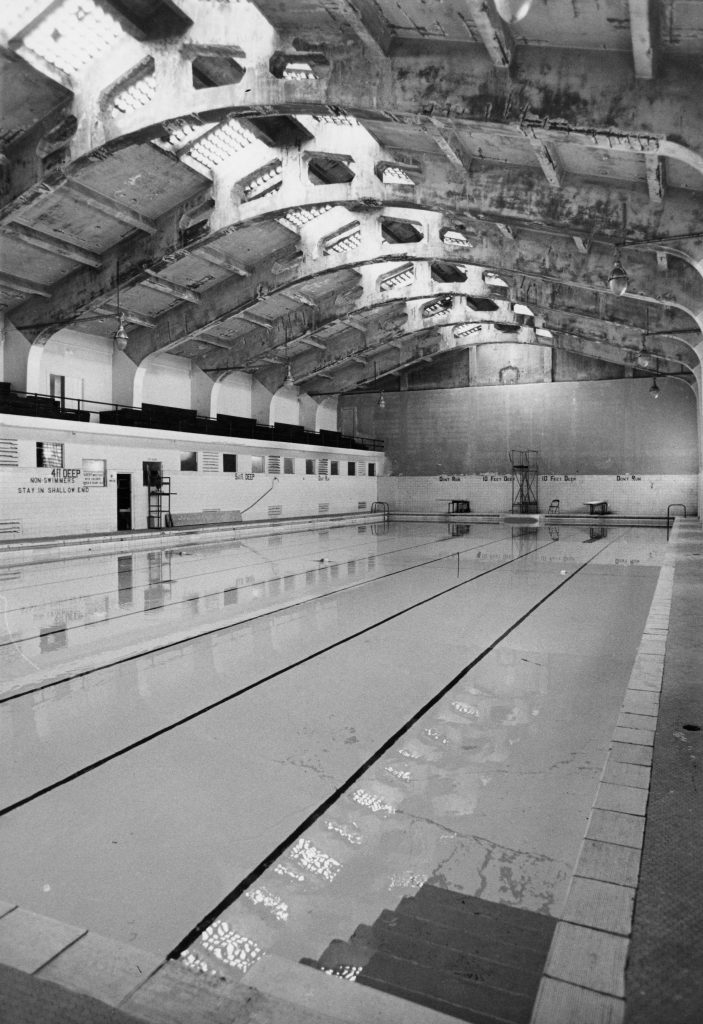
Built in 1921, the Wasatch Springs Plunge served as a municipal pool for fifty years, tapping into the natural hot springs at the far northern end of Salt Lake City. The building, located at 840 North and 300 West was built by noted architectural firm Cannon and Fetzer and is a striking example of Spanish Colonial Revival style architecture. In its heyday, the building had two pools, administrative offices, several private soaking tanks, a barbershop, a hairdresser, and men and women’s masseurs. Additionally, there were also five rooms available for overnight guests.[1]

The Warm Springs have been utilized by all groups of people who call this region home. Historian Kathryn MacKay notes, “The 2-3 mile strip of hot springs and lake had been used for preceding centuries by the American Indians – Shoshones, Utes, Paiutes – who traveled through the area on hunting, foraging, trading, and social expeditions.”[2] It is likely that white fur trappers who were known to have visited the adjacent area also visited the springs. The first written encounter with the springs comes from a California-bound group, who followed Hastings Cutoff in 1846, and wrote of the warm water and its distinctly unpleasant odor. Erastus Snow, who, along with seven others, arrived in advance of Brigham Young’s wagon train, wrote about the Warm Springs on July 22, 1847. After describing the location, and the rocks nearby, he noted the temperature by writing, “We had no instrument to determine the degree of Temperature but suffice it to say that it was about right for scalding hogs.” Snow decided “The springs are the greatest facilities for a steam doctor I ever saw.” [3]

Classified Photograph Collection, “Warm Springs Bath House P. 1.” Courtesy Utah State History.

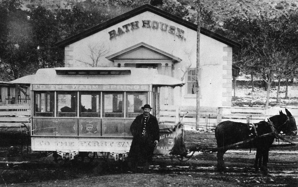
The permanent Euro-American settlement of the Salt Lake valley also marks the beginning of human-made structures intended to enhance the enjoyment of the natural springs. The springs were considered to have healing properties and were marketed not only for recreation but also for medicinal uses. In 1850, the Bath House opened and was within the purview of the neighboring Church of Jesus Christ of Latter-day Saints (LDS) 19th ward bishop’s responsibilities. By 1864, this building had fallen into disrepair and was no longer operated by the LDS Church. Over the next several decades the facilities were used for recreational purposes and, in 1916, Salt Lake City assumed ownership. It was at this point when the current structure was built and would remain in near-constant use for the next 85 years.

Classified Photograph Collection, “Warm Springs Bath House P. 15.” Courtesy Utah State History.
Classified Photograph Collection, “Warm Springs Bath House P. 14.” Courtesy Utah State History.
Classified Photograph Collection, “Warm Springs Bath House P. 16.” Courtesy Utah State History.

This period of the building’s history was not without problems. In 1946, concerns were raised over the sanitation of the water, and the city initially suggested chlorinating the pools. However, chlorine mixed with sulfur produces noxious chemicals, harmful to swimmers. As a compromise, the city decided to cap the natural hot springs, and the space was converted to a fresh-water, chlorinated pool.[4] Around that time, the pools began losing their appeal, and by the mid-1970s, they were no longer financially sustainable and were shuttered for nearly a decade before the Children’s Museum of Utah moved into the space in 1981.

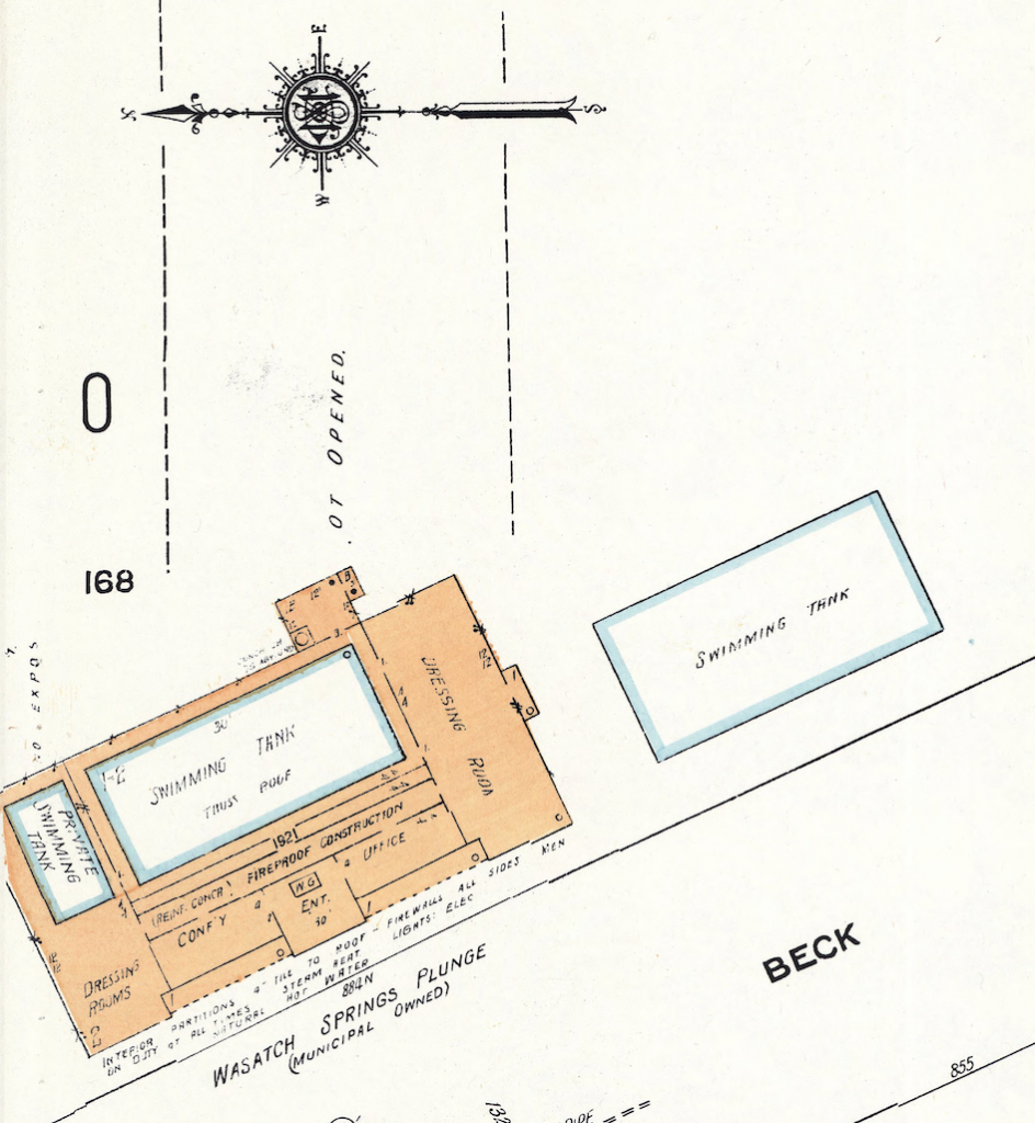
Sanborn Fire Insurance Maps, detail showing the Wasatch Springs Plunge in 1950. University of Utah Marriott Library, Print and Journal Division.

Today, the future of the building is unknown. Placed on the historic registry in 1980, the building has not been occupied full-time since the Children’s Museum of Utah moved out in 2006. The Golden Spike Train Club of Utah uses the space to house and work on their model railroad projects, but their future there is not guaranteed.[5] In 2016, Salt Lake City began accepting proposals for development, but eventually ruled out the possibility of putting housing on the site. A local organization, the Warm Springs Alliance, is advocating for the building to be used as warm springs once again.[6] However, this proposal faces significant financial hurdles. As of spring 2019, the building’s future is unknown, but there is no shortage of interest and enthusiasm for utilizing this historic gem in downtown Salt Lake.

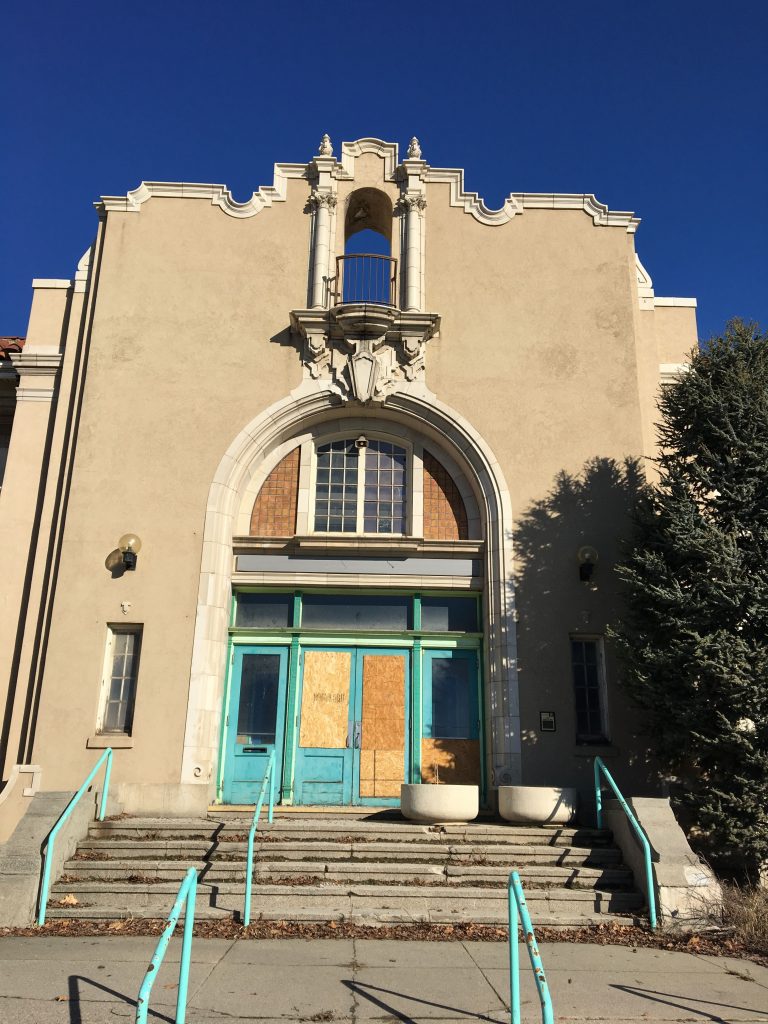
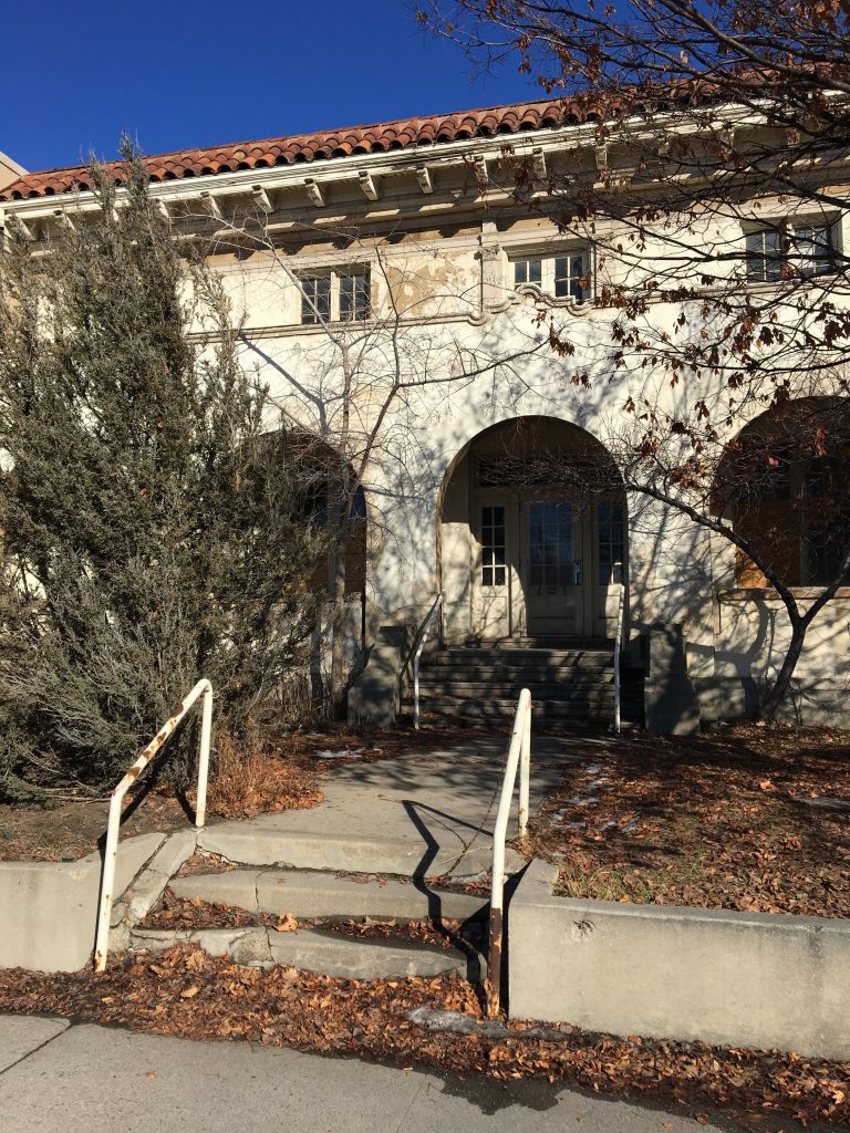
Wasatch Springs Plunge in February 2019.

For Further Reference:

Primary Sources:

Erastus Snow Journal, Church History Library, Church of Jesus Christ of Latter-day Saints, Salt Lake City.

Secondary Sources:

Lutz, Susan Juch. “Cleaned Up and Cleaned Out: Ruined Hot Springs Resorts of Utah.” GHC Bulletin (Energy and Geoscience Institute, University of Utah), 2004.

Jones, Darrell E. and W. Randall Dixon. “’It Was Very Warm and Smelt Very Bad’: Warm Springs and the First Bathhouse in Salt Lake.” Utah Historical Quarterly, Volume 76, Number 4 (2008): 212-226.

MacKay, Kathryn. “National Register of Historic Places Nomination Form: Wasatch Springs Plunge.” United States Department of the Interior Heritage Conservation and Recreation Service, 1980.

McFarland, Sheena. “Whatever happened to … Wasatch Springs Plunge?” The Salt Lake Tribune, December 23, 2014.

McLane, Michael. “The Children’s Museum.” Mapping SLC, http://www.mappingslc.org/this-was-here/item/243-the-children-s-museum.

McLane, Michael. “Past and Present Collide at Warm Springs.” Catalyst Magazine, December 1, 2017.


[1] Kathryn MacKay. “National Register of Historic Places Nomination Form: Wasatch Springs Plunge.” United States Department of the Interior Heritage Conservation and Recreation Service, 1980, 9.

[2] MacKay, “National Register of Historic Places Nomination Form,” 6.

[3] Erastus Snow Journal, July 22, 1847, as quoted in Darrell E. Jones and W. Randall Dixon. “‘It Was Very Warm and Smelt Very Bad’: Warm Springs and the First Bathhouse in Salt Lake.” Utah Historical Quarterly, Volume 76, Number 4 (2008): 212-226.

[4] MacKay, 9.

[5] Michael McLane. “The Children’s Museum.” Mapping SLC. http://www.mappingslc.org/this-was-here/item/243-the-children-s-museum. Accessed March 15, 2019. See also http://www.goldenspiketrainclubutah.org/ for information on the model train organization.

[6] http://www.warmspringsalliance.org/

First Church of Christ, Scientist, Salt Lake City

Published / by Gabe Martinez / 1 Comment on First Church of Christ, Scientist, Salt Lake City

Written by Gabe Martinez

Both markers placed by: The National Register of Historic Places, Division of State History

GPS Location: N 40° 45.755 W 111° 52.843

Historical Marker 1: No. S-28

Reads: First Church of Christ, Scientist, Salt Lake City: Organized July 17, 1891: Cornerstone laid June 4, 1898: Dedication November 27, 1898: Built of brick and kyune sandstone: Architect: W.E. Ware: First Christian Science Church established in Utah: Marker placed 1973

Marker placed by Division of State History
Taken by Gabe Martinez

Historical Marker 2: No. N-120

Reads:First Church of Christ, Scientist, The First Church of Christ Scientist in Utah was organized in Salt Lake City on July 17, 1891. The church, designed by architect Walter E. Ware, was constructed of brick and kyune sandstone. Dedicated on November 27, 1898, the building is the oldest Christian Science Church in Utah and one of the oldest continuously Christian Science Churches in the world.

Marker placed by Division of State History
Taken by Gabe Martinez

Extended Research:

Front of the First Church of Christ Scientist building
Taken by Gabe Martinez

This building upon its dedication on November 27, 1898 housed The First Church of Christ, Scientist. The First Church of Christ, Scientist began in 1866 in Boston Massachusetts. The church was founded by Mary Baker Eddy through a healing experience with The Bible after a severe slip and fall [1]. Upon establishing the church, years later in 1879, Eddy received a state charter to create the Massachusetts Metaphysical College where the doctrine of Christian Science was taught to missionaries [3]. One of her students, Mrs. M. A. Bagley graduated and brought the doctrine to Salt Lake City. On July 17, 1891 in the home of Mrs. M.A. Bagley along with 10 other individuals (8 women and 3 men total) The First Church of Christ, Scientist was formed in Salt Lake [3]. This building was fully funded by donations of the congregation and with the help of Walter E. Ware as the architect [4]. At the time of dedication, the church was able to seat 650 people but more than 1000 would show up to the services from all across the western frontier, with Mrs. M. A. Bagley leading  the service [1]. Little is known about all the members of the congregation but stories of individual members do survive.

Second level of First Church of Christ, Scientist building
Taken by Gabe Martinez

One of these members is Anna K. Craig. In 1892, Craig travelled to Utah to teach kindergarten at Brigham Young Academy. Along with being a devout practitioner of Christian Science, Craig was also a member of the Utah Sororis Club, a nineteenth-century club in Provo, and a member of the first Board of Directors of the Woman’s Council [8]. Craig was one of many great women of not only the Christian Science Church but also her community. She played an active role in pushing the state to implement kindergarten in the Utah educational system [8].

In 1869, several years before the dedication of the First Church of Christ Scientist building, the first non-Latter-day Saint worship building, The Church of the Good Samaritan, in Corinne, UT was constructed. Following the Good Samaritan, the first Catholic Church in Salt Lake City was built in 1871 [6]. After that, in 1883, a Baptist church joined the growing list of new religious buildings [7]. These along with many others like the First Church of Christ, Scientist were a part of a worship space revival in Utah as faith began to diversify due largely to an influx of immigrants from diverse religious traditions who arrived in the state from the 1880s to the 1920s.

Inside of First Church of Christ, Scientist building. Original organ pipes
Taken by Gabe Martinez

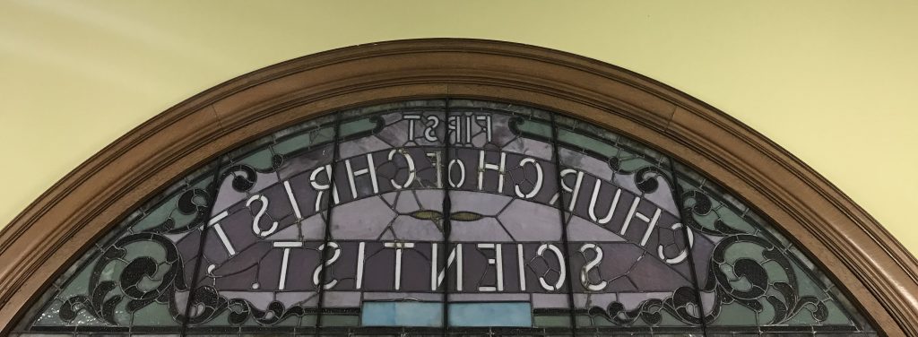
Most of the elaborate architecture and building features of the First Church of Christ, Scientist still stand today. For example the original organ and pipes remain but are not in use (pictured above). A majority of the wooden pews, including the ones on the second level, are original to the building (pictured above). All of the stained glass seen throughout the building is also original. Pictured below is the original stain glass window which reads “First Church of Christ Scientist” that can only be seen from the inside of the building.

Inside view of the front entrance stain glass of the First Church of Christ, Scientist building
Taken by Gabe Martinez

This building now houses The Light of the World Church (La Luz Del Mundo). The Light of the World Church is not affiliated with the First Church of Christ, Scientist or Christian Science. In 2002, members of the First Church of Christ, Scientist sold the historic building largely due to changing demographics in the congregation and a move from downtown Salt Lake City to other areas of the state. The building then became home to Anthony’s Fine Art and Antiques. In 2006, The Light of the World Church purchased the building from Anthony’s.

In 2019, Christian Science churches in Utah have active congregations in the Salt Lake City area, Ogden, and Park City [5].

Primary Sources:

[1] Eddy, Mary Baker, 1821-1910, and Scientist First Church of Christ. The Christian Science Journal. Boston: The Christian Science Publishing Society

Secondary Sources:

[2] Johnson, Jeffery Ogden. “Lucretia Heywood Kimball (1856–1920): Pioneer in Utah’s Early Christian Science Movement.” Worth Their Salt Too: More Notable But Often Unnoted Women of Utah, edited by Colleen Whitley, University Press of Colorado, 2000, pp. 55–60. JSTOR, .http://www.jstor.org/stable/j.ctt4cgpjz.7

[3] Cannon II, Kenneth L. “Brigham Bicknell Young: Musical Christian Scientist.” Utah Historical Quarterly 50.2 (1982): 124-38.

[4] United States Government, National Register of Historic Places Collection, First Church of Christ Scientist, 30 July 1976, https://npgallery.nps.gov/NRHP/AssetDetail?assetID=005ff433-712f-44ef-bd56-4ac9d0530b39

[5] https://en.wikipedia.org/wiki/Church_of_Christ,_Scientist#Recent_problems; Elizabeth Beall, Christian Science Committee on Publication for Utah.

[6] http://www.ereferencedesk.com/resources/state-history-timeline/utah.html

[7] http://www.firstbaptist-slc.org/find-out-more/church-history/

[8] Ventilla, Andrea. “Woman and the Kindergarten Movement in Utah”. Utah Historical Quarterly 81. 1-4 (2013) 133-150.

Joseph F. Steenblik Park

Published / by Juli Huddleston / Leave a Comment

Write-up by Julia Huddleston

View of Steenblik Park, February 2019.

GPS Coordinates: 40.787, -111.92H

Historical Marker Text:

Joseph F. Steenblik was a friend of youth and a builder of men in cultural, physical, and spiritual activities. Born in Salt Lake City, Utah in 1904, he lived in the Rose Park area since 1908. Over the years, Joseph promoted many scout activities, such as Scout-O-Rama, and chaired scout fund drives. In addition to his support of the Boy Scouts, Joseph recognized that girls need outdoor outings as much as boys. He was instrumental in the organizing and building of the Rose Park Library, Rose Park Gymnasium, and the local church Stake House. He was a good example of a Good Samaritan, kind to the less fortunate, good to his employees, and exemplified the values of dependability and hard work.

Open 8:00 A.M. to 11:00 P.M.

Leashed dogs only

No alcoholic beverages

Dairy Cats

2007

Day Christiansen

The “Dairy Cats” were developed with the Steenblik Dairy, a longtime presence in the Rose Park Neighborhood, in mind. The cats are sited so children and adults can enjoy them as they visit or walk through Steenblik Park. The four cats are cast in bronze with variations in patina resulting in a diversity of colors combined with the classic richness of bronze.

“Dairy Cats” is a project of the Salt Lake City public art program, managed by the Salt Lake City Arts Council under the direction of the Salt Lake City Art Design Board. Thanks to the neighborhood representatives who assisted with the project, and also to the City Council member Carlton Christensen, Rose Park Community Council, SLC Parks, SLC Housing and Neighborhood Development, SLC Engineering, and the Department of Community Development.

Dairy Cats by Day Christiansen.

Extended Research:

Joseph F. Steenblik Park is a pocket park located in the heart of the vibrant and closely-knit Rose Park neighborhood in the northwest quadrant of Salt Lake City. Real estate developer Alan Brockbank gave Rose Park its name after he saw a corner market store with blooming rose bushes, which the storeowner credited to the fertile soil in the area. Inspired by the roses, Brockbank gave the new streets names of unusual rose varieties such as American Beauty, Rambler, Talisman, Sonata, Autumn, Debonair, and Nocturne.[1] Rose Park consists primarily of one-story red brick houses, with an architectural cohesion not often found in Salt Lake’s other older neighborhoods.

Even though many of the homes are close to seventy years old, this is not the first housing development to occupy the space. By 1911, the Oakley Park subdivision had become home to many railroad employees of various races, ethnicities, and religious backgrounds due to the proximity to the railroad yards outside downtown Salt Lake City. However, by the mid-1940s the neighborhood was badly blighted, and the health department gave residents an ultimatum to “rid themselves of a collection of horses, cows, stray dogs, hogs, ducks, turkeys, chickens, and goats” or move elsewhere.[2] Brockbank, who created the master plan for the new 2,000-home Rose Park subdivision in 1946, expedited this cleanup effort to meet the post-WWII demand for affordable housing for growing families. While not initially wholly positive for the residents (the new subdivision implemented regrettable restrictive covenant clauses prohibiting people of color from purchasing homes), the area rebounded and is once again welcoming and inclusive, boasting one of the highest rates of racial and ethnic diversity in the Salt Lake valley.[3]

Detail from Sanborn Fire Insurance map showing the Oakley Park subdivision in 1911. Marriott Library Special Collections, Print and Journal Division.

Throughout all these changes, the Steenblik family proved to be a consistent and influential presence in the neighborhood. Joseph F. Steenblik, along with his extended family, was instrumental in both the history and growth of the area. Born in 1904 in Salt Lake City, his parents had emigrated from the Netherlands the year previously. The family moved to Rose Park in 1908, where Joseph and several siblings lived for much of their lives. The family owned and operated Steenblik Dairy, a small-scale dairy farm that supplied milk to Salt Lake’s west side.[4] The dairy, which was located adjacent to the family home at 1442 W. Leadville Avenue, was established around 1920 and was operational into the 1970s. [5] After serving a mission for the Church of Jesus Christ of Latter-day Saints (LDS) to Holland, Steenblik married Ruth Reid, and the couple had seven children.

Joseph F. Steenblik’s home, adjacent to Steenblik Dairy. Tax assessment photograph, 1936. Courtesy Salt Lake County Archives.

In addition to working on the family dairy farm, Joseph, alongside his brother Roelof, operated a construction company—Steenblik Construction—which was incorporated in 1952. They were instrumental in aiding with the construction of the Rose Park Stake House, an impressive and unusually large meeting place for the local Latter-day Saint congregations. The building has two chapels, allowing for simultaneous worship services, two meeting halls for social gatherings, a courtyard, a gymnasium, as well as a detached recreation building. Steenblik served as the Stake president (an ecclesiastical position roughly equivalent to a bishop over a Catholic diocese) in addition to other important religious leadership roles.[6] Joseph F. Steenblik died in 1991, at the age of 87.

Steenblik Dairy, commercial tax assessment photograph, 1978. Salt Lake County Archives.

The Joseph F. Steenblik Park was built in 1984 with federal block grant funding, and was named in the “Name the Park” competition proposed by Mayor Palmer DePaulis.[7] In 2007 Salt Lake City commissioned local artist Day Christiansen to create a work of public art that would be emblematic of the neighborhood. Paying homage to Steenblik Dairy, his sculpture Dairy Cats consists of four five-foot tall bronze statues of seated cats that represent mouser cats often found on farms. The park pays tribute to Joseph F. Steenblik and his family’s lasting legacy in Rose Park. His influence is still visible throughout the neighborhood, and has contributed to the vibrancy and resiliency of the community.


[1] Charles L. Doane, Leo W. Russon, Archie S. Hurst, Salt Lake Rose Park Stake History 1955-1980: A Sesquicentennial Project,(Salt Lake City, Utah: Salt Lake Rose Park Stake, Inc. 1980).

[2] Richard W. Bernick, “S. L. Demands West Side Area Cleanup,” Salt Lake Telegram, 6 August, 1948.

[3] Chris Dunsmore, “Rose Park,” Mapping SLC, http://www.mappingslc.org/this-was-here/item/151-rose-park, March 7, 2019.

[4] “Roelof Steenblik Obituary,” Salt Lake Tribune,  December 26, 2002.

[5] Doane, Russon, and Hurst, Salt Lake Rose Park Stake History 1955-1980: A Sesquicentennial Project, Salt Lake City, Utah: Salt Lake Rose Park Stake, Inc. 1980, 2.

[6] Doane, Russon, and Hurst, (Salt Lake Rose Park Stake History) 207.

[7] Susan Lyman, “Mini-Parks Neighborhood Folk Heroes Find Their Place in the Shade,” Deseret News, August 28, 1988. Accessed via the Deseret News online archive.

For Further Reference:

Primary Sources:

Richard W. Bernick. “S. L. Demands West Side Area Cleanup.” Salt Lake Telegram, 6 August, 1948.

Alan Brockbank papers, Ms 604, Marriott Library Special Collections, University of Utah.

“Roelof Steenblik Obituary.” Salt Lake Tribune.  December 26, 2002.

Salt Lake County Tax Assessment Records, Salt Lake County Archives.

Sanborn Fire Insurance Maps, University of Utah Marriott Library.

Secondary Sources:

Doane, Charles L., Leo W. Russon and Archie S. Hurst. Salt Lake Rose Park Stake History, 1955-1980: A Sesquicentennial Project. Salt Lake City: Salt Lake Rose Park Stake, 1980.

Dunsmore, Chris. “Rose Park.” Mapping SLC, http://www.mappingslc.org/this-was-here/item/151-rose-park. March 7, 2019.

Lyman, Susan. “Mini-Parks: Neighborhood Folk Heroes Find Their Place in the Shade.” The Deseret News, August 28, 1988.