Category Archives: Pioneer Settlement

Settlement of Hatch

Published / by Ashley Sawyer / 2 Comments on Settlement of Hatch

Write-up by Ashley Sawyer

Placed by: The Daughters of the Utah Pioneers, No 292

GPS Coordinates: 37°38’57.6″N 112°26’05.0″W

Settlement of Hatch Historical Marker

Historical Marker Text:

In 1872 Meltair Hatch settled at the head of Sevier River, near the junction of Mammoth and Asay Creeks. He engaged in stock raising and operated a water-power sawmill. Soon other settlers came. Land was surveyed and irrigation ditches dug. Lime was burned by Neils P. Clove. First School was in the Hatch Home, Abram Workman Teacher. 1888 the Asay Postoffice was transferred to Hatch, Neils Ivor Clove, Postmaster. In 1892 The Church of Jesus Christ of Latter-day Saints organized Mammoth Ward, Aaron Asay Bishop. 1899 The ward name was changed to Hatch. 1901 to 1904 the town was moved to the present site under the Leadership of Bishop Rosmus Lynn. Camp Hatch Garfield County, Utah

Extended Research:

In 1867, LDS Church Leaders called Meltiar Hatch and his two wives, Permelia and Mary Ann to settle the Dixie Mission, in Eagle Valley, in present day Nevada. At the time, settlers believed they were in the western part of Utah Territory. In 1866, Congress changed state boundaries, but surveyors did not determine the location of those boundaries until the fall of 1869, when Meltiar and his family learned that they were living in Nevada. In response to the news “Meltiar went to St. George to discuss with President Brigham Young about their situation. President Young advised Meltiar to move back to an area on the Sevier River near the forks of Mammoth and Asay Creeks, as there would be good range for their sheep, cattle, and horses which they had acquired while living in Dixie.”1

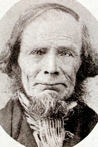
Meltiar Hatch, Courtesy of
LDS Church

 Given this directive from Young, Hatch moved his second wife Mary Ann and Permelia’s sons to Panguitch in Southern Utah. The next Spring, Permelia and the rest of the family also moved to Panguitch. As more families moved into Panguitch, the residents created a co-op and gathered a sizeable herd. The co-op decided to move the herd twenty miles south of Panguitch, to a ranch. “Meltiar and one of his sons took charge of this enterprise. They built a log home and corrals where Mammoth Creek tumbles down Cedar Mountain to join the Sevier River.”2

Meltiar moved his second wife, Mary Ann, and her family onto the ranch. Mary Ann cooked for the ranch hands and welcomed newcomers and travelers. Other settlers moved into the area of the Co-Op Ranch. The Hatch home thus became the center of what developed into a new town. The Hatch home held school sessions and LDS church services. The Co-Op Ranch was eventually renamed Hatchtown or Hatch. By 1880 about 100 residents lived in or near the community2.

As with most small agricultural communities in the semi-arid West, residents of Hatch had to worry about water. In October of 1901, The Upper Sevier Reservoir Company began building a large dam which would ensure plenty of water for irrigation purposes for the towns of Hatch, Panguitch, and surrounding areas. The new dam provided much needed water, but by March 1903, residents of the region expressed concern that the new dam would not hold. In March 1903, the Salt Lake Tribune reported that “The work on the reservoir is not far enough along to enable the water to run off through the spills as fast as it comes from the creek above, and there is grave danger of a break.”3  On May 19, 1903, those fears were realized when the dam broke. The breaking of the Hatchtown Dam only caused some damage to the ranchers of Circleville (42 miles north of Hatch) and fortunately did not directly impact Hatch, other than the loss of water it produced.

In May of 1907, the Inter-Mountain Republican Newspaper announced a call for bids to rebuild the Hatchtown Dam. On December 17, 1907, state engineer Caleb Tanner reported to the Inter-Mountain Republican, that the new dam would be ready by spring 1908. However, construction dragged on for several more years when tragedy struck again.

 On May 25, 1914, the new dam broke. The Ogden Daily Standard call it “the biggest dam break by far in the history of Utah” and reported that it occurred at 3 o’clock in the afternoon. “The breaking of the dam let loose a small ocean, as the reservoir, which was protected by the dam, contained approximately 14,000 acre feet of water,” the Standard explained.4 When the dam broke, more than 15 homes were swept away, and 75 people or more were left homeless. Some reports claimed that up to 300 residents of the Upper Sevier Valley, including some in Hatch ended up displaced by the flood. This was the second time the Hatchtown dam broke in less than ten years. For a quiet little town like Hatch these events were traumatic and proved to be major historical incidents.

Residents of Hatch eventually recovered and life returned to normal. In the twenty-first century, Hatch is a sleepy little town with several quaint restaurants and motels. The town mostly caters to travelers along scenic US 89 as well as lodgers looking for adventure in nearby Bryce Canyon National Park.

1 Hatch Historical Committee, Wandering Home: Stories and Memories of Ira Stearns Hatch, Meltiar Hatch, and John Henry Hatch and their Wives and Children, with Historical-Genealogical and Biographical data on their Ancestry and Descendants (Provo, Utah: Community Press, c1988.) Page 32

2 Linda King Newell and Vivian Linford Talbot. A History of Garfield County. (Salt Lake City, UT: Utah State Historical Society; Garfield County Commission, 1998.) Page 115, 117

3 “Danger of Dam Breaking” Salt Lake Tribune 27 March 1903. https://newspapers.lib.utah.edu/ark:/87278/s6df823x/13563224

4 “Reservoir Breaks near Panguitch in This State” Ogden Daily Standard 26 May 1914 https://newspapers.lib.utah.edu/ark:/87278/s62v3hx6/6743268

Primary Source:

“Bids Are Asked for Sevier River Dam” Inter-Mountain Republican 29 May 1907 https://newspapers.lib.utah.edu/ark:/87278/s63x94mw/3914343

“Hatchtown Dam Ready in Spring” Inter-Mountain Republican 17 December 1907 https://newspapers.lib.utah.edu/ark:/87278/s6w103wt/3932113

“Hatchtown Reservoir to be Ready in March” Inter-Mountain Republican 15 January 1909 https://newspapers.lib.utah.edu/ark:/87278/s60k36nh/3975787

“Panguitch Notes” Salt Lake Herald-Republican 26 October 1901 https://newspapers.lib.utah.edu/ark:/87278/s60v9jgf/10376304

 “Reservoir Gives Way” Salt Lake Tribune 20 May 1903 https://newspapers.lib.utah.edu/ark:/87278/s66m4hnt/13533477

 “Utah Settlers Flee for Their Lives When the Hatchtown Dam Breaks” Salt Lake Telegram 26 May 1914 https://newspapers.lib.utah.edu/ark:/87278/s64n0c9w/19935271

Secondary Source:

Hatch Historical Committee, Wandering Home: Stories and Memories of Ira Stearns Hatch, Meltiar Hatch, and John Henry Hatch and their Wives and Children, with Historical-Genealogical and Biographical data on their Ancestry and Descendants. Provo, Utah: Community Press, c1988.

Newell, Linda King, and Vivian Linford Talbot. A History of Garfield County. Salt Lake City, UT: Utah State Historical Society; Garfield County Commission, 1998.

Supplemental Photos

Photo of Hatch Ward Building and Bell Marker
Photo of Hatch Ward Building and Bell Historical Marker Close up
Hatch Daughters of the Utah Pioneers Museum

Old Meeting House – Draper Fort

Published / by Aaron Ika / Leave a Comment

Write Up by Aaron Ika

Placed by: Daughters of Utah Pioneers, No. 56, January 1940

GPS Coordinates: 40° 31′21′′ N, 111° 51′56′′ W

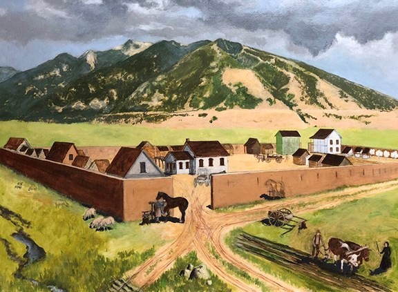
Photo Credit: Rendering of the Old Draper Fort in Pioneer Times (1850’s) – Draper Historical Society

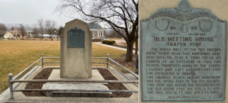
Historical Marker Text:

ERECTED JANUARY 1940

“OLD MEETING HOUSE” DRAPER FORT

            THE NORTH WALL OF THE “OLD MEETING HOUSE’ STOOD NEAR THIS MONUMENT. HERE (1861-1869) DR. JOHN R. PARK BEGAN HIS CAREER AS AN EDUCATOR IN UTAH. THIS SCHOOL PRODUCED MANY OF THE STATES LEADERS AND LEFT AN INDENIBLE LOVE FOR THE EDUCATION IN DRAPER.

THE GRANITE BLOCK IN THIS MONUMENT WAS THE SOUTH STEP OF THE OLD CHURCH. THIS SPOT WAS WITHIN THE ENCLOSURE OF THE OLD ADOBE FORT 184 YDS. X 113 YDS. THE WALL WAS 14 FT. HIGH AND 3 FT. THICK.

EBENEZER BROWN CAMP

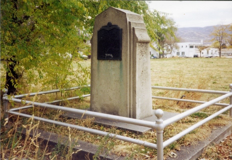
Historical Marker View in Draper Historical Park
Photo Credit: Draper Historical Park (1990) – JacobBarlow.com
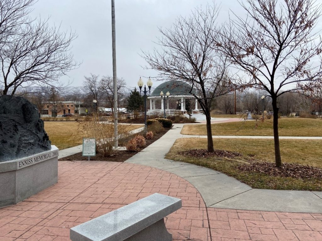
Draper Historical Park (2020) – Home of the Old Meeting House – Draper Fort Marker

Extended Research:

The marker for the Old Meeting House Draper Fort commemorates two important pieces of history in Utah and the city of Draper: the Draper Fort and the Old Meetinghouse that sat inside the fort. The marker is located on the north side of Draper Historic Park.

Settlers moved to the south east end of the Salt Lake Valley into an area called South Willow Creek in 1850. The area grew rapidly and by the end of 1852, 20 families called South Willow Creek home.[1] In 1854, the establishment of the first post office brought a name change to the town. The area came to be known as Draperville, in honor of William Draper JR, who was a prominent member of the Church of Jesus Christ of Latter-day Saints (LDS). In 1877, the town shortened the name to Draper.[2]

On 10 April 1854, Brigham Young addressed the followers of his church: “from hence forth, let one and all go forth with one accord and build their forts, wall in their cities and villages, herd and guard their cattle and other property and keep their guns and ammunition in good order and convenience, ready for instant use.”[3] Skirmishes erupted from Sanpete to Salt Lake Counties between Native Americans under Ute Chief Walkara and settlers. Walkara had become upset by Mormon efforts to stifle Indian slave trading and by the increased intrusion of settlers into traditional Native American hunting grounds.[4] This broader violence shaped the first Mormon settlement in the area that became Draper.

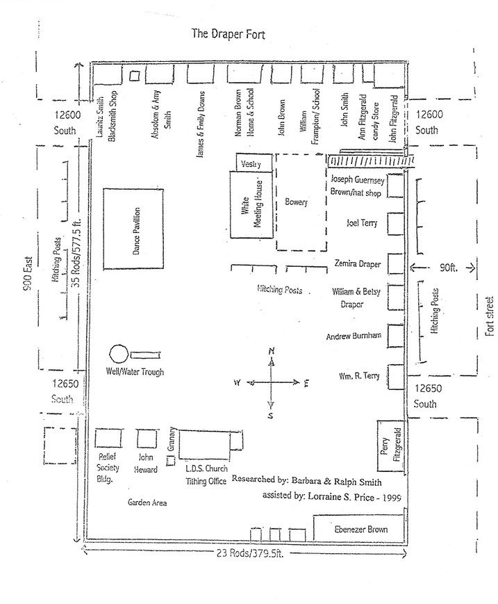
Ebenezer Brown and his family were the first settlers to arrive in “South Willow Creek” in 1849. Ebenezer’s homestead was 160 acres. Because of the Native threat, and at Brigham Young’s directive, Ebenezer donated 5 acres of his property to build a fort where members of the community could gather and feel safe. In late 1854, the fort construction began for protection to those pioneers homesteading in the area. It took two years to build walls of adobe brick and clay around the fort that measured 23 rods east to west and 35 rods north to south. A Rod is an old English measure of distance equal to 16.5 feet (5.029 meters). The walls were eight feet high and one foot wide with look-out slots every fourteen feet. All homes faced the center of the fort.[5]

Photo Credit: Ebenezer Brown – Courtesy of the Draper Historical Society

The Draper Historical Society has researched the fort extensively and created a map of houses and shop locations inside the fort.

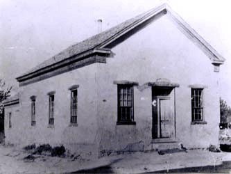
The entrance to the fort was a dirt road through a wide opening in the northwest corner of the fort and in front of Lauritz Smith’s blacksmith shop. A garden area was at the southwest end of the fort. It included a small orchard of apple and peach trees, planted by William Terry with seeds he carried across the plains from Rhode Island. John Fitzgerald’s home was built on the northeast corner of the fort. John’s mother, Ann, had a candy store attached to the home. The first house built was Ebenezer’s, and then running west along the south wall were three other small homes. Perry Fitzgerald’s two-story home was built on the east wall and to the west was the LDS Church tithing office and granary and the Relief Society Hall. Ebenezer’s son, Norman Brown, built an adobe brick house. This house also served as Draper’s first schoolhouse. From its beginning, Draper showed a special interest in education. Schooling began right away with Betsy Draper, wife of William Draper, as Draper's first teacher. Town leaders were always on the lookout for qualified teachers and paid them out of their own pockets. By the year 1855 the population of the community had grown to 222 people. Up until then church, school and public meetings were held in homes. More space was needed, so in 1860 the vestry was built across from the Norman Brown home. In 1863 the main hall was added to the vestry, and from that time the building was known as "The Old White Meetinghouse".[6]

The fort was an essential part of the community and provided the settlers with a sense of security and comfort during the early history of Draper.[7] Due to the increased tensions with the Native Americans and the settlers, many people tended to things outside the fort during the day such as their own homes, cows, sheep and other livestock. At night they returned to the fort to be safe from home raids. The temporary homes inside the fort were for sleeping only. They were very small with some being just one room. Some were no larger than a wagon box. Difficulties with Native American tribes lessened by the late 1850’s. The fort was never attacked, and families began returning to their homes. Ebenezer Brown deeded the “center area” of the fort to the community.[8] The fort was disbanded around 1864 and the fort walls were gradually dismantled. The Old White Meetinghouse and some of the original homes remained and in 1892 the Draper First Ward Church was built on the property.[9]

Draper Fort as researched by Draper Historical Society

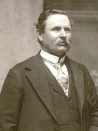
The Draper Fort housed one of the town’s most essential buildings, the schoolhouse. Settlers of Draper built the first schoolhouse in 1852 on the north wall of the Draper Fort.[10] The schoolhouse became home to early educator, John Rocky Park. The schoolhouse also served as a public and spiritual gathering place for nearly twenty years after construction.[11] Park was an integral figure in education in not just Utah but in the expansion of the western territories of the United States. Park was at one time, president of the University of Deseret, that was later renamed the University of Utah. In 1895, Park was elected as Utah Superintendent of Education.[12]

Photo Credit: Old White Meetinghouse – Courtesy of the Draper Historical Society

Draper became known as the “Cradle of Education” in the West.[13] The Draper curriculum of John Rocky Park became known for its excellence at all grade levels. Park gained notoriety for his school and what was being taught inside its walls. With Trustee funding, Dr. Park, provided blackboards, maps and charts.[14] Brigham Young even wanted to build the University in Draper but disputes over land caused the site to move locations.[15] A student of those days reminisced: “The [school’s] walls were soon covered with maps and charts illustrative of all departments of knowledge. Models and globes rested on the broad window seats. A tellurion, a miniature illustration of the planetary system, was provided . . .”[16] Author Ralph Chamberlain found evidence of the renowned success of John R. Park’s school in Draper: “From a little country village, with a population of about 300, secluded in a corner of the Salt Lake Valley, in a brief period of five years that still stands out as its golden age, went forth a surprising number of men who later achieved high success; and in that village developed a spirit and movement that in time spread beyond it and inaugurated in Utah an educational regeneration. Never was the potential power of the good teacher more strikingly demonstrated.”[17]

Photo Credit: Dr John R Park – Courtesy of the Draper Historical Society

In January 1940, the Ebenezer Brown Camp of the Daughters of the Utah Pioneers erected a monument on the original site of the old meetinghouse. The granite block in the monument was the south step of the old church.[18]

For Further Reference:

Primary Sources:

James Herman Tegan, “Pioneer Personal History” Survey, The Works Progress Administration (Utah Section) Biographical Sketches, 1939, https://collections.lib.utah.edu/ark:/87278/s6pv8qj7

John Hamilton Morgan, “Scans of miscellaneous papers related to John Hamilton Morgan”, Digitized by J. Willard Marriott Library, University of Utah, 1951-1952, https:/collections.lib.utah.edu/ark:/87278/s6dn4xjn

John R. Park papers, MS 0242, Box [ ]. Special Collections and Archives. University of Utah, J. Willard Marriott. Salt Lake City, Utah.

Elisabeth Boulter Enniss, Journal 1874 – 1879, Draper Historical Society Museum, Draper, Utah

Secondary Sources:

PETERSON, CHARLES S. “A New Community: Mormon Teachers and the Separation of Church and State in Utah’s Territorial Schools.” Utah Historical Quarterly 48, no. 3 (Summer 1980): 293-312.

Willey, Darrell S. “Utah’s Frontier Architect of Social Destiny: John R. Park.” Peabody Journal of Education 38, no. 2 (1960): 100-06.

Noel Ennis, True to the Faith: The Life of W.B. Enniss 1857-1947, (Pioneer Books, 2004)

Draper Historical Society, “The History of Draper, Utah, vol. 2: Sivogah to Draper City 1849-1977”, (Agreka Books 2001)

Draper Historic Preservation Commission, “Draper History,” Draper Utah’s Historic Buildings, May 19, 2017, accessed April 2, 2020

Draper Historic Preservation Commission, “Draper Park School,” Places that Matter – Draper, Utah, May 2014, accessed April 2, 2020

University of Utah, and Ralph V. Chamberlin. 1949. Memories of John Rockey Park

Footnotes:

[1] Draper Historical Society, “The History of Draper, Utah, vol. 2: Sivogah to Draper City 1849-1977”, (Agreka Books 2001)

[2] Noel Ennis, True to the Faith: The Life of W.B. Enniss 1857-1947, (Pioneer Books, 2004)

[3] Draper Historic Preservation Commission, “Draper History,” Draper Utah’s Historic Buildings, May 19, 2017, accessed April 2, 2020

[4] University of Utah, and Ralph V. Chamberlin. 1949. Memories of John Rockey Park

[5] Draper Historic Preservation Commission, “Draper History,” Draper Utah’s Historic Buildings, May 19, 2017, accessed April 2, 2020

[6] Draper Historic Preservation Commission, “Draper History,” Draper Utah’s Historic Buildings, May 19, 2017, accessed April 2, 2020

[7] Draper Historic Preservation Commission, “Draper Park School,” Places that Matter – Draper, Utah, May 2014, accessed April 2, 2020

[8] Draper Historic Preservation Commission, “Draper History,” Draper Utah’s Historic Buildings, May 19, 2017, accessed April 2, 2020

[9] Draper Historical Society, “The History of Draper, Utah, vol. 2: Sivogah to Draper City 1849-1977”, (Agreka Books 2001)

[10] John R. Park papers, MS 0242, Box [ ]. Special Collections and Archives. University of Utah, J. Willard Marriott. Salt Lake City, Utah.

[11] John R. Park papers, MS 0242, Box [ ]. Special Collections and Archives. University of Utah, J. Willard Marriott. Salt Lake City, Utah.

[12] University of Utah, and Ralph V. Chamberlin. 1949. Memories of John Rockey Park

[13] University of Utah, and Ralph V. Chamberlin. 1949. Memories of John Rockey Park

[14] PETERSON, CHARLES S. “A New Community: Mormon Teachers and the Separation of Church and State in Utah’s Territorial Schools.” Utah Historical Quarterly 48, no. 3 (Summer 1980): 293-312.

[15] Draper Historic Preservation Commission, “Draper Park School,” Places that Matter – Draper, Utah, May 2014, accessed April 2, 2020

[16] Elisabeth Boulter Enniss, Journal 1874 – 1879, Draper Historical Society Museum, Draper, Utah

[17] University of Utah, and Ralph V. Chamberlin. 1949. Memories of John Rockey Park

[18] Draper Historic Preservation Commission, “Draper History,” Draper Utah’s Historic Buildings, May 19, 2017, accessed April 2, 2020

First Wayne Stake Tithing Office

Photo Credit: Bill Kirchner, Sept. 29, 2018

GPS Coordinates:

38º 24.114’ N     111º 38.681’ W

Marker is in Loa, Wayne County, Utah.

Photo Credit: Andrea Maxfield, January 20, 2020.
Photo Credit: Andrea Maxfield, January 20m 2020.
National Register of Historic Places Marker

Built in 1897, the Loa Tithing Office is historically significant as one of 43 well preserved tithing buildings in Utah that were part of the successful “in kind” tithing system of The Church of Jesus Christ of Latter-day Saints (Mormons) between the 1850s and about 1910. Tithing lots, which usually included an office and several auxiliary structures, were facilities for collecting, storing, and distributing the farm products that were donated as tithing by church members in the cash-poor agricultural communities throughout the state. Tithing offices were a vital part of almost every Mormon community, serving as local centers of trade, welfare assistance, and economic activity. This building is also architecturally significant as one of ten existing examples of Utah’s tithing offices which were designed in the Greek Revival style. Peter Christensen, who constructed the building, also fired the brick in a kiln located between the nearby town of Lyman and Horse Valley Ranch. The woodwork on the building was carved by Benjamin E. Brown, a local craftsman. In 1972 the building was sold to the local chapter of the Daughters of Utah Pioneers.

–National Historic Places Registry, Date Unknown

DUP Marker No. 396

First Wayne Stake Tithing Office built in 1897 at a cost of $1,000 by Peter Christensen who fired the brick in a kiln between Lyman and Horsevalley Ranch. Benjamin F. Brown carved the wood decorations. Used only for tithing office as long as offerings were paid in produce. It then became the Wayne Stake Presidential Office. Now owned by Daughters of Utah Pioneers, where pioneer relics are displayed and meetings held.

–Mauna Loa Daughters of Utah Pioneers, 1976

Extended Research:

Photo Courtesy: LDS Church History Library and Archives, Wayne Stake Office/Old Tithing Building, PH 211.

Tithing offices were found in every settlement of the Church of Jesus Christ of Latter-day Saints throughout the Mountain West during the nineteenth century. These houses played a major role in the economic life of their communities. Historically, they were an extension of the communal storehouse which was established by Latter-day Saints in Missouri in the early 1830s. Leaders of the newly organized “Church of Christ,” as it was then called, established a system under the law of consecration, which asked all members to donate their surplus income and wealth to the church. The funds were used to buy land, construct temples, and provide for the needs of the poor. The law of consecration was replaced in 1838 by a “lesser law” of tithing, which required members to pay one-tenth of their annual increase or net income.[1]

Once the Latter-day Saints were established throughout Utah Territory, the receipt and disbursement of tithes necessitated the construction of a tithing office, a storehouse, and often a stockyard in every settlement. The tithing office, storehouse, and stockyard were under the management of the local clergy called stake presidents and bishops.[2]

As the membership of the Church increased in Utah, Latter-day Saint congregations were divided into geographic units called stakes usually named after the county or region they occupied and overseen by a three-man stake presidency. Stakes were subdivided into smaller units called wards, a term borrowed from voting districts in the early United States. Wards in the LDS Church were overseen by a bishop and two counselors, who reported to stake leadership. Members of the wards or stakes paid tithes to the Church in various forms, ranging from cash, labor, or grain, to livestock and produce, depending on an individual’s financial circumstances. Tithes paid were disbursed by the bishop or stake president for assistance to the poor and needy within their jurisdiction.

First Wayne Stake Presidency: Joseph Eckersley, Gerson Bastian, John Riley Stewart
Photo Credit: Andrea H. Maxfield, September 2019.

First Wayne Stake Presidency: Joseph Eckersley, Gerson Bastian, John Riley Stewart

Photo Credit: Andrea Maxfield, September 2019

Though Latter-day saints began settling in Rabbit Valley as early as 1865, Wayne County wasn’t officially organized until May 2, 1892. The elevation of the communities in the county vary from 7,300 feet at Loa to 4,200 feet at Hanksville.[3] The broad spectrum of elevation, and proximity to the mountains and Fremont River created difficulties for settlements in adapting to unpredictable weather patterns. Freezing temperatures, heavy storms, and flooding often interfered with farming and settlers were dependent upon the assistance of stake tithes to survive.

Facing west, Wayne tithing office and Loa tabernacle (Wayne Stake) Photo Credit: Andrea Maxfield, January 20, 2020.

In response to these hardships, in 1897, members of the Wayne Stake followed the counsel of Church headquarters in Salt Lake City and built a white brick building to serve as the Wayne Stake tithing office. There were originally two floors, the main floor, and a cellar used for storing vegetables and potatoes. Behind the building was a large wooden granary where the clerks stored grain paid as tithing. Further east of the granary, church members stacked the hay brought in for credit.

In February 1897, Bishop Levi C. White of Blue Valley (later Giles) said, “The Ward is in Good conditions, owing to the recent storm the people have not been able to do mutch ditch work. Had it not been for the donations made to their ward by the Saints in the upper settlements, they would not have been able to raise crops this year. The people greatly appreciate the Generocity of the saints who have donated to their needs.”[4] Again, in May of the same year, Hans W. Hansen reported the good results that came from “the liberal donations of the people of the western part of the stake to those living in the eastern part.”[5]

Members of the stake willingly paid tithes to help preserve their economy. George S. Bastian of Loa, stated that nothing gave him “more joy than to take of his substance and help the poor and needy.” And Elias W. Blackburn of Bicknell reminded members of his congregation that they had “made a promise in the Nauvoo temple to help the poor and needy,” and now he could say he had spent the past “six months exclusively in making good this promise.”[6]

Labor was also a common donation for tithing. The Wayne Stake tithing office was likely financed through labor donations. The white bricks for the structure were made in a kiln between Lyman and Horse Valley by Peter Christensen, a member of the stake, who then laid the brick. Benjamin Brown another Latter-day Saint member in the stake made the fancy woodwork on the doors and porches.[7]

Photo Credit: Andrea Maxfield, September 2019.

By the early twentieth century as communities became more financially secure, tithing in kind gradually dwindled throughout the stakes. After Latter-day Saints in Wayne Stake discontinued the payment of tithes “in kind,” the granary behind the tithing office was moved to another location in Loa. The white brick building was then used as the stake clerk’s office until the 1950s when the Loa Tabernacle/Stake Center across the street added a cultural hall and stake offices.[8]

The Mauna Loa Daughters of Utah Pioneers purchased the tithing office building and currently use it for DUP meetings and as a museum which houses antiques, photos and other artifacts from early Wayne County.

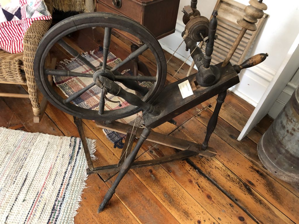
German Spinning Wheel housed in Wayne Tithing Office. Photo Credit: Andrea Maxfield, September 2019.
Pipe organ from Loa Tabernacle, also on display in the Wayne Tithing Office. Photo Credit: Andrea Maxfield, September 2019.

Notes:

[1] Leonard J. Arrington, “The Mormon Tithing House: A Frontier Business Institution,” The Business History Review, 28:1 (March 1954), 24.

[2] Arrington, “This Mormon Tithing House,” 25.

[3] Anne Snow, Rainbow Views: A History of Wayne County, 4th Ed. (Springville, Utah: Art City Publishing Co, 1985), 1-18.

[4] Loa Stake General Minutes 1893-1981, Church History Library, The Church of Jesus Christ of Latter-day Saints, Call Number: LR 9963 11, 219-20.

[5] Loa Stake General Minutes,226.

[6] Loa Stake General Minutes, 223.

[7] Snow, Rainbow Views, 422.

[8] Loa Utah Stake Manuscript History and Historical Reports, Church History Library, The Church of Jesus Christ of Latter-day Saints, Call Number: LR 9963 2.

For Further Reference:

Primary Sources:

Loa Stake General Minutes 1893-1981, Church History Library, The Church of Jesus Christ of Latter-day Saints, Call Number: LR 9963 11

Loa Utah Stake Manuscript History and Historical Reports, Church History Library, The Church of Jesus Christ of Latter-day Saints, Call Number: LR 9963 2

Secondary Sources:

Leonard J. Arrington, “The Mormon Tithing House: A Frontier Business Institution,” The Business History Review, 28:1 (Cambridge: The President and Fellows of Harvard College, 1954), 24-58.

Anne Snow, Comp., Rainbow Views: A History of Wayne County, 4th Ed.(Springville, UT: Art City Publishing Co., 1985).

Pioneers of Antimony

Published / by Eric Montague / 13 Comments on Pioneers of Antimony

Pioneers of Antimony

Write-up: Eric Cecil Montague

Placed By: Daughters of Utah Pioneers Forrest Camp · · · Garfield County (1949)

G.P.S. Coordinates: 38° 6.907′ N, 111° 59.8′ W

Historical Marker Text:

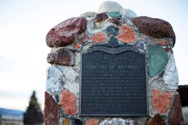
In 1873, Albert Guiser and others located in a fertile meadow, which they named Grass Valley. Surveyors camped on a stream, lassoed a young coyote and called the place Coyote Creek. The first L.D.S. settlers were Isaac Riddle and family, who took up land on the east fork of the Sevier River. Later, a school house was built, and the Marion Ward organized with Culbert King as bishop. In 1920 the name was officially changed to Antimony after the antimony mines east of the valley.

A picture on the day of the dedication of the marker with Antimony townswomen – Amber Riddle and Maude Wiley on the left and Esther Mathews and Ethel Savage on the right. (Courtesy of the Mayor’s Office – Antimony, Utah)

Extended Research:

The history of Antimony is a story of diverse groups making a home in a beautiful valley. Much like the story of Utah at large, these groups consisted of Native Americans, early settlers from the Church of Jesus Christ of Latter-day Saints (L.D.S.), and miners. The fertile valley of Antimony has been known by several names over the years: Clover Flat[1], Grass Valley[2], Coyote[3], and after 1920, Antimony. The latest name was chosen because of the abundant antimony mines in the canyons that surround Antimony and the mining industry that the mineral supported. This valley is covered in lush grass that is naturally irrigated by Otter Creek and the East Fork of the Sevier River.

The primary native people of the valley were Southern Paiute Native Americans. Previously, approximately 10,000 years ago, early native peoples, including the Fremont and Ancestral Puebloan peoples, inhabited Southern Utah.[4] Twenty-seven miles south of Antimony, at the ranch of Jeff Rex, archaeologists found ruins known as the North Creek Shelter Site. These ruins provide insight into the lives of the native peoples that inhabited the area before European settlement. The site, used as temporary shelter by many generations of hunters and travelers, contains artifacts from the Paiutes and earlier native peoples. Artifacts found at North Creek include stone tools, farming equipment, projectiles for hunting, pottery, and other common native objects.[5] The item from the North Creek site that received the most acclaim was a wild potato; this is the earliest documented use of potatoes in North America.[6]

North Creek Shelter Site

The more recent peoples of the region are linguistic relatives of the Utes, known as the Kaiparowits Band of the Southern Paiute.[7] Shoshone bands also occupied the area. Both groups used the substance now known as antimony (a very brittle, bluish-white metallic substance),[8] which they extracted from the canyons around Grass Valley,[9] for tools and weaponry. This Southern Paiute band engaged with Europeans (Mormon settlers and the U.S. Army) during the Black Hawk War (1865–1872), and Europeans settled permanently in the region shortly thereafter. The small Southern Pauite band that lived in Grass Valley called themselves the Paw Goosawd Uhmpuhtseng or Water Clover People.[10]

The earliest Anglo-European contact with the region occurred as a result of the Spanish Trail and the John C. Fremont explorations. A trading path off the Old Spanish Trail called the Gunnison trail was used during the 1830s and 1840s. The trail split at the summit of Salt Creek in Salina Canyon. From there, the path passed through Seven Mile Canyon and Fish Lake, descended along Otter Creek, and continued along the Sevier to the Pahvant Mountains.[11] Trading caravans used this path to supply two economies: goods and slaves. The most prominent trade goods were furs, buckskin, and dried buffalo meat. In addition, the Ute people sold captured Southern Paiutes as slaves to the Spanish traders.[12] Later, in the winter of 1853–1854, Captain John C. Fremont made his fifth and final expedition to the Western territories. During this expedition, Fremont encountered harsh weather and searched for safety. After a long trip through the San Rafael Swell, Capitol Reef, and the Awapa Plateau, Fremont and his group followed Otter Creek into Grass Valley, and there found shelter and recuperated.[13] The party later continued to Parowan for further recovery. In a letter to his sister about his trials, Fremont wrote that “the Mormons saved me and mine from death and starvation.”[14]

During the Black Hawk War, Mormon settler Captain James Andrus received orders from Brigadier General Erastus Snow to conduct a reconnaissance mission throughout Southern Utah to ascertain the strength of Native American communities in the region. This group passed through Grass Valley on September 4, 1866. In Grass Valley, the soldiers found the most “extensive” defense works they had ever encountered, erected by the Southern Paiutes.[15]

Brigham Young, then president of the L.D.S. Church, organized the first Mormon exploration party into Grass Valley in 1873, following the end of the Black Hawk War. The group included Albert K. Therber, William Jex, Abraham Holladay, General William Pace, George Bean, and George Evans. Throughout Southern Utah, Chief Tabiona of the Shoshone tribe served as their guide. During their exploration of Southern Utah, on June 18, 1873, they camped at what is known today as Antimony Bench. That evening, they recorded in their journal that “We were just going to camp for the night when we saw an old coyote with three young ones. We gave chase and caught the little ones, cut their ears off short, tied a paper collar around one’s neck and turned them loose. We named the stream Coyote.”[16] Thus, Grass Valley was renamed Coyote.

In 1873, the first European settler arrived in the valley: Albert Guiser. Guiser and his family owned mines in Oregon, namely the Bonanza, the Brazos, the Pyx, and the Worley mines. He likely came to Utah as a mining speculator because of the propaganda surrounding Utah during the national mining fervor and its promised mineral riches. Guiser established a cattle operation in the valley as well, yet did not establish a permanent settlement or buildings in Coyote, only visiting during summer.[17]

To understand the account of Antimony’s first permanent settlers, one must be acquainted with the practice by the adherents of the Mormon faith known as the United Order. The United Order, established by Brigham Young, was an economic concept based on cooperative and communitarian ideals. In the Order, all property was held in common, whereby its participants’ goal was to become self-sufficient from the external world. Most United Order communities only lasted a few years before dissolving.[18] Two Order communities that had lasting effects on Antimony were Kingston and Circleville. John Rice King, son of the leader of the Order in Kingston, purchased the Antimony Guiser cattle operation as part of the Order.[19] Two prominent future leaders of Antimony came from United Order communities: Isaac Riddle and Culbert King, from Kingston and Circleville, respectively. Riddle used Grass Valley to graze the Order’s cooperative beef herd. The Order from Kingston built a dairy beside Riddle’s ranch in Antimony.[20] After the dissolution of the Order in 1878, Isaac, Culbert, and others came to Grass Valley.

Isaac Riddle was the first permanent settler in Coyote. Riddle was born in Boone County, Kentucky, where his family converted to the Mormon faith and moved to Nauvoo, Illinois. He enjoyed his time making shingles for the Nauvoo temple. Riddle spoke of the challenges that he encountered from the “mobbers of Illinois,” who persecuted the Mormons. He also described the troubles of 1844 that the Mormons encountered in Nauvoo at the murder of the founder of Mormonism, Joseph Smith. Notably, he wrote a description of Smith’s death, stating that “he cannot tell how we felt.” For the next six years, while migrating to Utah, Riddle endured numerous trials. His three-year journey to Winter Quarters in Omaha resulted in his “destitute condition.” To add further challenges, Riddle’s father left him in charge of the family in Omaha for two years when he was only 17 years old. After his arrival in Utah, Brigham Young called on Riddle and Jacob Hamblin to go on a mission to Southern Utah to improve relations with the native people.[21] Riddle’s exploration of Utah resulted in his acquisition of a vast estate throughout Southern Utah. In 1875, Riddle and his son, Isaac Jr., built ranches on the east fork of the Sevier River in Grass Valley.[22] Isaac and his son had explored the area the year before and assessed it to be perfect for cattle because of its abundant water and natural meadows. In addition to Riddle, John Hunt, Joseph Hunt, Gideon Murdock, and Walter Hyatt all used Antimony for cattle grazing.[23] Riddle was a shrewd businessman. To this end, he allotted a part of his ranches as a stopover for travelers on their way to Hole-In-The-Rock.[24] Riddle’s financial interests not only included ranches, but he also established many grist mills and sawmills throughout the region. After the dissolution of the United Order, Riddle owned thousands of cattle, sheep, and horses. He was also a polygamist with multiple wives, which resulted in his incarceration, along with George Q. Cannon, an apostle of the L.D.S. Church, from September 1887 to February 1888 for polygamy under the Edmunds Tucker Act. Riddle died on September 1, 1906.

Isaac Riddle

Isaac Riddle in Prison for Polygamy with George Q. Cannon (L.D.S. Apostle) Riddle is the in the second row, first person on left side

In 1878, around the Riddle Ranch, the town of Antimony began when thirty-three Mormon families—some of whom were friends of the Riddles—moved into the valley. The most noteworthy among the settlers were the Eliza Esther McCullough, Elizabeth Ann Callister, Sarah Elizabeth Pratt, Lydia Ann Webb, and Culbert King families; the Eliza Syrett and Volney King family; the Helen Maria Webb and John King family; the Mary Theodocia Savage and John Dingman Wilcox family; the Esther Clarinda King and George Black family; the Polly Ann Ross and Culbert Levi King family; the Christina Brown and Mortimer W. Warner family; the Charles E. Rowen family; the Knute Peterson family; the Peter Neilson family; and the James Huff family.[25]

Antimony Post Office 1896

Of the first settlers in Antimony, one prominent member of the community, Culbert King, became the spiritual leader of the early Mormon settlers. King was born on January 31, 1836, in the state of New York. His parents joined the L.D.S. Church and moved to Illinois. In Nauvoo, the King family became acquainted with the religious leader, Joseph Smith. Following Smith’s murder they joined the migration of the Saints in 1846, arriving in Utah in 1851. Shortly after their arrival, Brigham Young sent the Kings to Fillmore, Millard County, where they erected the first house in the area. King served as a soldier during both the Walker and Black Hawk wars. Afterward, he became a friend to the Southern Paiutes and became somewhat proficient in speaking their language. After staying for 15 years in Kanosh, he moved to Circleville, Piute County, where he lived in the United Order for several years and served as a member of the ecclesiastical leadership there until the Order dissolved. He then relocated to Grass Valley and, in 1882, became bishop of the L.D.S. ward. From December 1885 to June 1886, he was imprisoned for polygamy. He continued to serve as bishop until 1901 when he was released and ordained a patriarch by Apostle Francis M. Lyman. He died on October 29, 1909. He and his wives were all buried in Antimony.[26]

Culbert King

Culbert King with Primary Assocation

The most prominent non-Mormon settler and early miner in Antimony was Archibald Munchie Hunter. After emigrating from Scotland to the United States through Boston in 1851, Hunter’s career took him across the nation. In 1874, he arrived in Utah and resided in Sevier County as a breeder of thoroughbred racehorses. In 1879, he joined the settlers in Antimony. That he felt at home in Antimony is no surprise, given the communitarian beliefs of the town founders and Hunter’s prominence as a socialist. He spent the rest of his life there, supporting himself by providing supplies to various mining speculations, running a hotel, and raising and exporting his horses to Scotland. The successful mining efforts of Hunter and others gave the town its current name—Antimony—after the mineral that he and others mined in the canyons above the town. When he moved to Antimony in 1879, Hunter became chairman of the school board, and residents who experienced financial difficulties testified to Hunter’s generosity. Hunter cared for his sister, Jane Talbot, and her five children in his home, which he also ran as a hotel. He died in Antimony in 1931 and was buried in Salt Lake City.[27]

Archibald M. Hunter

Archibald Hunter with Family in front of his hotel

Archibald, as a school board trustee and benefactor, is significant to another group of Antimony pioneers: its earliest women. Female pioneers in Antimony influenced the town substantially, most notably as teachers and nurses. Carrie Henry, Lydia Tebbs Winters, and Esther Clarinda Black were the first teachers in Coyote. In 1882, at the home of George Black, the first schoolhouse was built, and in 1885, the school found its more permanent residence in the newly built church, until a dedicated school building was built in 1916. The school’s most remembered teacher was Esther Clarinda Black. One of her students, Lillian McGillvra Abbott, remembered her as having a “pleasant disposition.”[28] Black’s daughter, Esther Black Matthews, revered her mother. She recalled that Black began to teach out of necessity to provide for her family while her husband, George Black, served a mission for the L.D.S. Church in England.[29] Black’s impact on the community cannot be understated due to her effect on the town’s children. Black served for 23 years as the town leader of the youth organization of the L.D.S. Church, named the Primary Association, thus influencing the education and spiritual lives of the town’s children.[30]

Lydia Tebbs Winters with Antimony School Children

In addition to teaching, Esther was also a midwife. Midwifery and nursing were vital to the health of the young town. The first baby born in Antimony was Forrest King, son of John R. and Helen King, on April 1, 1879.[31] Some of the most esteemed nurses were Catherine Wilcox Webb and her two daughters, Helen Matilda Webb King and Lydia Webb Huntley,[32] among whom Catherine’s history is remarkable. Her first husband was Eber Wilcox, a member of Zion’s Camp, a Mormon militia organized by Joseph Smith to reclaim property stolen from members of the faith by Missourians. Wilcox died of cholera while on the Zion’s Camp expedition at Fishing River.[33] Joseph Smith officiated over Catherine’s marriage to her second husband, John Webb, in Kirtland, Ohio.[34] Catherine and her family came to Utah as original overland pioneers with the James Pace Company in 1850[35] and settled in Fillmore. After Catherine’s husband was killed guarding the fort at Fillmore during the Black Hawk War,[36] she joined her children in Coyote. She and her daughters were excellent nurses. Upon Catherine’s death, her obituary said of her that “her sphere of usefulness was unbounded as she assisted at the birth of many and at the bedside of the sick. She knew her profession well and was extensively known and well-beloved by all her acquaintances.”[37]

Catherine Wilcox Webb

From its humble pioneer beginnings, the town now known as Antimony made its mark on the Utah history in both the 19th and 20th centuries. The infamous Butch Cassidy and his group of criminal outlaws often frequented the area when it was known as Coyote and one-time marshal George Black encountered the gang there.[38] The telephone line arrived in Antimony in 1912, permanently connecting the town to the outside world.[39] That same decade, Antimony contributed in two ways to World War I. First, it sent eight of its young men to serve: Alonzo Black, Nelo Brindley, Loril Carpenter, Glen Crabb, Wilford Davis, Gus Lambson, David Nicholes, and Arnold Smoot. All eight returned home with honorable discharges. In addition to its soldiers, two antimony mines shipped ore to ammunition plants as part of the war effort. Following the war, the global influenza pandemic claimed four of Antimony’s residents: George Jolley, Arella Smoot, Thomas Ricketts, and Nephi Black.[40]

The official incorporation of Antimony as a town occurred in 1934, during the peak of its population. The 1880 census counted the town’s population as 125, and it rose in the 1920s and 1930s to its all-time peak of 290. It then precipitously declined until it began to rise again in 2000 and is just over 130 today. In 1938, The Works Progress Administration of the New Deal brought culinary water to Antimony.[41] Its population decline over the 20th century is a result of the difficulties of farming and mining in the region. The antimony mines closed after World War I. Without mining, Antimony had to rely solely on its agriculture. Antimony has always been a farming community, with the potato as its most common crop. The former importance of potato farming is demonstrated all over Antimony today in the potato cellar derelicts that dot the highway and roads throughout town.

Antimony Potato Cellar

While World War II was raging half a world away, L.D.S. Apostle Marion G. Romney spoke at the dedication of the newly built Antimony Ward chapel on April 23, 1944. In his dedicatory prayer, Romney prayed for those from Antimony and the rest of the U.S. who were serving overseas. He said, “Bless our boys and girls in the armed services who are spread out upon the earth in this great war.”[42] Antimony sent the following young men to battle in World War II: Lark Allen, Wayne Allen, Burns Black, Noel Black, Dean Crabb, Keith Crabb, Keith Gates, Robert Gates, Dahl Gleave, Marthell Gleave, George Jolley, R.J. Jolley, Arthell King, Darral King, Eugene King, Fount Lambson, Boyd Lindquist, Verl McInelly, Alton Mathews, Dasel Mathews, Gerald Mathews, Calvin Montague, Cecil Montague, Arden Nay, Clinton Nay, Harvey Nay, Merrill Nay, Guyle Riddle, Ted Riddle, James Sandberg, Lynn Savage, LaMaun Sorenson, Harmon Steed, Robert Steed, Arther Twitchell, Clarence Twitchell, Ephrium Twitchell, Grant Warner, Robert O. Warner, Warren Wildon, Carling Young, and Verl Young. All of these men returned home, except for three who were killed in action: Lark Allen, Ted Riddle, and Arther Twitchell. On Friday, May 30, 1947, the town held a service in honor of its war veterans. It was presided over by the president of the Panguitch L.D.S. Stake, Douglas Q. Cannon, and the bishop of the L.D.S. ward, Chester Allen, who had lost his son, Lark.

Antimony War Veterans Plaque – WWI & WWII

Dedicatory Services for Bronze Plaque Program Cover

Dedicatory Services for Bronze Plaque Program Inside

In 1946, electricity arrived in Antimony. The first home in which the Garkane Power Company installed its service was that of Avera and Ivan Montague.[43] Throughout the first half of the 20th century, dances were held in one of the canyons leading out of Antimony at the Purple Haze dance hall. When it opened, for 50 cents, people from towns around Antimony came to hear the live orchestra and dance late into the night as the sunset cast a purple haze over the canyon. The dance hall closed in the 1960s as the popularity of social dancing subsided.[44]

Throughout the last half of the 20th century, Antimony’s population dwindled, even dipping below 100 residents in 1990. One reason for this was the declining potato crop industry and other farming struggles.[45] Another reason was the pull factor that drew the younger generations of Antimony into larger cities. Population decline usually has a negative economic effect on rural towns. The impact of this is evident in the median income of Antimony households dropping to $22,500 in 2010, as reported by the 2010 census. However, since its lowest population point, Antimony is rebounding, largely due to its tourism and recreational significance, as the town is on the route to Bryce Canyon, a U.S. National Park. Antimony also has the advantage of being part of the American Discovery Trail, a non-motorized trail that one can use to travel across middle America. The trail is “a new breed of national trail—part city, part small town, part forest, part mountains, part desert—all in one trail. Its 6,800+ miles of continuous, multi-use trail stretches from Cape Henlopen State Park, Delaware, to Pt. Reyes National Seashore, California.”[46] Furthermore, Mayor Shannon Allen has brought popularity to Antimony with a fireworks display every Independence Day. Antimony is home to many highly popular attractions: the Antimony Mercantile, Otter Creek Reservoir, and the Rockin’ R Ranch. The “Merc” is well-known for its half-pound Antimony Burger, the Rockin’ R for its dude ranch experience, and Otter Creek for its unprecedented trout fishing. As its citizens attest, Antimony owns a special place in Utah’s history.

References

Primary Sources

Abbott, Lillian McGilvra. My Life Story. No Date. http://utahhistoricalmarkers.org/primary-source/1693/

Deseret News (July 1884): 16.

Garfield County News (April 1923): 6.

The Engineering and Mining Journal (1896).

The Joseph Smith Papers, Journals 1 (1832–1839).

Fremont, Capt. J. C. Report of the Exploring Expedition to the Rocky Mountains in the year 1842 and to Oregon and North California in the years 1843-44. Washington: Gales and Seaton, printers, 1845. https://books.google.com/books?id=W8ICAAAAMAAJ&oe=UTF-8

King, Culbert Biographical Sketch of Culbert Levi King. No Date. http://utahhistoricalmarkers.org/primary-source/biographical-sketch-of-culbert-king/

Mathews, Esther Black. A Short Sketch of My Life: Daughters of the Utah Pioneers. 1947. http://utahhistoricalmarkers.org/primary-source/a-short-sketch-of-my-life-esther-black-mathews/

Riddle, Isaac. “Autobiography of Isaac Riddle.” In The Descendants of John Riddle, edited by Chauncey Cazier Riddle, 2003. http://utahhistoricalmarkers.org/primary-source/autobiography-of-isaac-riddle/

Utah Department of Heritage & Arts. “Archibald Murchie Hunter Papers.” No date. https://collections.lib.utah.edu/details?id=462879#idm45468671543968.

Utah Digital Newspapers. ” Salt Lake Tribune | 1885-12-13 | The Second District Court.” No date. https://newspapers.lib.utah.edu/details?id=13144326&page=3&facet_paper=%22Salt+Lake+Tribune%22&date_tdt=%5B1885-12-13T00%3A00%3A00.000Z+TO+1885-12-13T00%3A00%3A00.000Z%5D.

Wallace, John Hankins. Wallace’s Monthly 9 (1883).

Secondary Sources

American Discovery Trail. “INFORMATION ABOUT THE AMERICAN DISCOVERY TRAIL.” No date. https://discoverytrail.org/about/.

Biography of Catherine Narrowmore. Fillmore, Utah: Daughters of the Utah Pioneers. No Date.

Brown, Harlow F. Grass Valley History. Ogden: FamilySearch International, 1937.

Chidester, Ida, and Eleanor Bruhn. Golden Nuggets of Pioneer Days: A History of Garfield County. Panguitch, Utah: The Garfield County News, 1949.

Crampton, C. Gregory. “Military Reconnaissance in Southern Utah, 1866.” Utah Historical Quarterly 32, no. 2 (1866): 145–161.

Gottfredson, Peter, Indian Depredations in Utah. Salt Lake City: Press of Skelton Publishing Co., 1919.

Gunnerson, James H. The Fremont Culture: A Study in Culture Dynamics on the Northern Anasazi Frontier, Papers of the Peabody Museum, vol. 59, No. 2. Harvard University Press, Cambridge, 1920.

Janetski, Joel C., Mark L. Bodily, Bradley A. Newbold, and David T. Yoder. “Deep Human History in Escalante Valley and Southern Utah.” Utah Historical Quarterly 79, no. 3 (2001): 5–24.

Jensen, Andrew. Encyclopedic History of the Church of Jesus Christ of Latter-day Saints. Salt Lake City: Press of Skelton Publishing Co., 1941.

Kelly, Isabel T. Southern Paiute Ethnography. Lake City: University of Utah Press, 1964.

Louderback, Lisbeth A., Bruce M. Pavlik “Ancient potato use in North America.” Proceedings of the National Academy of Sciences 114, no. 29 (July 2017): 201705540.

Mormon Historic. “North America & Hawaii.” No date. http://mormonhistoricsites.org/zions-camp/.

Newell, Linda King, and Vivian Linford Talbot. A History of Garflied County. Salt Lake City: Utah State Historical Society, 1998.

Newell, Linda King. A History of Piute County. Salt Lake City: Utah State Historical Society, 1999.

Nielsen, Mabel Woodard, and Audrie Cuyler Ford. Johns Valley: The Way We Saw It. Springville: Art City Publishing Co., 1971.

Periodic Table of the Elements. “Antimony.” https://mineralseducationcoalition.org/elements/antimony/.

Probasco, Christian. Highway 12 – Hoodoo Lands and the Rim Red and Bryce Canyons, the Paunsaugunt Plateau. Salt Lake City: Utah State University Press, 2005.

Reeve, W. Paul, and Ardis Parshall. Mormonism: A Historical Encyclopedia. Santa Barbara, California: ABC-CLIO, 2010.

“Catherine Webb.” Overland Travel Pioneer Database, The Church of Jesus Christ of Latter-day Saints. https://history.churchofjesuschrist.org/overlandtravel/pioneers/5927/catherine-webb.

Warner, M. Lane. Antimony, Utah – Its History and Its People 1873-2004, 2nd ed. Provo, Utah 2004.

[1] John Hankins Wallace, Wallace’s Monthly 9 (1883): 625.

[2] Andrew Jensen, Encyclopedic History of the Church of Jesus Christ of Latter-day Saints (Salt Lake City: Press of Skelton Publishing Co., 1941), 4.

[3] Lane M. Warner, Antimony, Utah – Its History and Its People 1873-2004, 2nd ed. (Provo, Utah, 2004), 5.

[4] James H. Gunnerson, The Fremont Culture: A Study in Culture Dynamics on the Northern Anasazi Frontier, Papers of the Peabody Museum, vol. 59, No. 2 (Harvard University Press, Cambridge, 1920).

[5] Joel C., Janetski et al. “Deep Human History in Escalante Valley and Southern Utah,” Utah Historical Quarterly 79, no. 3 (2001): 5–24.

[6] Lisbeth A. Louderback and Pavlik M. Bruce, “Ancient potato use in North America,” Proceedings of the National Academy of Sciences 114, no. 29. (July 2017): 201705540.

[7] Isabel Kelly, “Southern Paiute Ethnography,” Anthropological Papers No. 69, Glen Canyon Series No. 21 (Salt Lake City: University of Utah Press, 1964)

[8] Periodic Table of the Elements, “Antimony,” https://mineralseducationcoalition.org/elements/antimony/.

[9] Warner, Antimony, Utah, 4.

[10] Linda King Newell and Vivian Linford Talbot, A History of Garflied County (Salt Lake City: Utah State Historical Society, 1998), 62.

[11] Harlow F. Brown, Grass Valley History, (Ogden: FamilySearch International, 1937), 2.

[12] Newell and Talbot, A History of Garflied County, 43.

[13] Brown, Grass Valley History, 2.

[14] Capt. J. C. Fremont, Report of the Exploring Expedition to the Rocky Mountains in the year 1842 and to Oregon and North California in the years 1843-44 (Washington: Gales and Seaton, printers, 1845).

[15] Gregory C. Crampton, “Military Reconnaissance in Southern Utah, 1866,” Utah Historical Quarterly 32, no. 2 (1866): 159.

[16] Peter Gottfredson, Indian Depredations in Utah (Salt Lake City: Press of Skelton Publishing Co., 1919): 324-330.

[17] The Engineering and Mining Journal (1896): 383.

[18] W. Paul Reeve and Ardis Parshall, Mormonism: A Historical Encyclopedia (Santa Barbara, California: ABC-CLIO, 2010), 287.

[19] Newell and Talbot, A History of Garflied County, 119.

[20] Newell and Talbot, A History of Garflied County, 127.

[21] Riddle, Isaac. 2003. Autobiography of Isaac Riddle in The Descendants of John Riddle. Edited by Chauncey Cazier Riddle.

[22] Jensen, Andrew. 1941. Encyclopedic History of the Church of Jesus Christ of Latter-day Saints. Deseret News. 4.

[23] Nielsen, Mabel Woodard, and Audrie Cuyler Ford. 1971. Johns Valley: The Way We Saw It. Springville, UT: Art City Publishing Co. 196.

[24] Probasco, Christian. 2005. Highway 12 – Hoodoo Lands and the Rim Red and Bryce Canyons, the Paunsaugunt Plateau. Utah State University Press. 33.

[25] Chidester, Ida, and Eleanor Bruhn. 1949. Golden Nuggets of Pioneer Days – A History of Garfield County. Panguitch, Utah: The Garfield County News. 124.

[26] Jensen, Andrew. 1941. Encyclopedic History of the Church of Jesus Christ of Latter-day Saints. Deseret News. 185

[27] Archibald Murchie Hunter Papers, 1871-1933.  MSS B 68. Utah State Historical Society Archive, Salt Lake City, Utah

[28] Mathews, Esther Black. 1947. A Short Sketch of My Life: Daughters of the Utah Pioneers.

[29] Abbott, Lillian McGillvra. My Life Story

[30] Garfield County News. 1923. April 20: 6.

[31] Linda King Newell, A History of Piute County (Salt Lake City: Utah State Historical Society, 1999), 129.

[32] Newell and Talbot, A History of Garflied County, 120.

[33] http://mormonhistoricsites.org/zions-camp/

[34] The Joseph Smith Papers, Journals, vol. 1 1832-1839.

[35] https://history.churchofjesuschrist.org/overlandtravel/pioneers/5927/catherine-webb

[36] Biography of Catherine Narrowmore. Fillmore, Utah: Daughters of the Utah Pioneers.

[37] Deseret News. 1884. July 30: 16.

[38] Warner, Antimony, Utah ,96.

[39] Newell and Talbot, A History of Garflied County, 222.

[40] Newell and Talbot, A History of Garflied County, 258.

[41] Newell and Talbot, A History of Garflied County, 294.

[42] Warner, Antimony, Utah, 71.

[43] Newell and Talbot, A History of Garflied County, 300.

[44] Warner, Antimony, Utah, 77.

[45] Newell and Talbot, A History of Garflied County, 337.

[46] https://discoverytrail.org/about/

Antimony Mining Company Stock Certificate
Kennedy Ditch

Published / by Jaclyn Foster / Leave a Comment

write-up by Jaclyn Foster

Placed By: Daughters of the Utah Pioneers, no. 96

GPS Coordinates: N 40º44’021” W 111º51’554”

Historical Marker Text:

Photo via Waymarking.com

Daughters of Utah Pioneers
No. 96
Erected 1947

THE KENNEDY DITCH

The Kennedy Ditch was an early pioneer irrigation canal taken out of Parley’s Canyon stream near 17th East. The construction was achieved as a co-operative work project, and the new channel named after its first Water Master, Charles Kennedy, a Utah pioneer of 1848. The area thus brought under cultivation, covered 864 acres of small farm lands extending west of 13th East from near 21st South northward to 9th South, including this spot on Emerson Avenue.
Emerson Camp    Salt Lake County

Photo via Waymarking.com

Extended Research:

Early European explorers of Utah referred to the region as the “Great American Desert.” Most explorers believed the region was unsuitable for settlement, despite the fact that it had sustained Ute, Goshute, Paiute, and other tribes for thousands of years. In 1843, however, John Fremont published a report that suggested the western base of the Wasatch Mountains could be colonized by creating an irrigation system from mountain streams.1

When the Mormon pioneers arrived in the Salt Lake Valley in 1847, creating a planned system of irrigation canals was one of their first priorities. Mormon leader Brigham Young sent an advance party of able-bodied men to the Salt Lake Valley in July of 1847, with the goal of planting crops and building shelters before winter. This advance party laid out city blocks, farmland, and irrigation canals. Subsequent waves of Mormon pioneers expanded upon this planned, communal settlement pattern. City lots were divided into wards, which were supervised by bishops. These bishops oversaw the process of creating irrigation ditches for each ward.

Charles Kennedy. Image via churchofjesuschrist.org.

Communal ownership of water was an important innovation for the Mormon pioneers. In the East, laws commonly mandated that water could not be taken from streams unless it was returned without a reduction in volume. This was clearly impossible in the Salt Lake Valley’s semi-arid environment. Instead, Brigham Young declared that there would be “no private ownership” of water; dams and ditches were constructed by ward communities, rights to use the water depended on whether the land was being cultivated, and public authorities were appointed to supervise and apportion water use. This public authority was called the Water Master, who was appointed by the high council. One Water Master oversaw multiple wards.2

Charles Kennedy was the Water Master of the Kennedy Ditch and surrounding area. He joined the Church of Jesus Christ of Latter-day Saints in Nauvoo, Illinois in 1844 and was endowed in 1846. During the migration to Utah, Kennedy served as Commissary for 50 wagons, which meant he was in charge of distributing goods. He was part of the 1848 Brigham Young Company and settled in the Sugar House Ward, where he was appointed Water Master. Sometime between 1860 and 1867, Kennedy left the Mormon Church and moved to Missouri with two of his wives. He died in 1890.3

The missing historical marker

The Kennedy Ditch no longer exists. The current marker at the site of the Kennedy Ditch is missing. However, an online community called Waymarkers, where users log their visits to local landmarkers as a type of real-life scavenger hunt, provides clues about when this marker disappeared. Waymarkers documented the marker up until June 1, 2011; the next entry, on December 12, 2013, notes that the marker had been removed.4 It may be stored in the LDS chapel that currently occupies the site, but its whereabouts are uncertain.

For Future Reference:

Primary Sources

“Charles Kennedy,” Mormon Pioneer Overland Travel 1847-1868, churchofjesuschrist.org

“Charles Kennedy,” Missouri Death Records 1834-1910, 1890.

Secondary Sources

Arrington, Leonard. Great Basin Kingdom: Economic History of the Latter-day Saints 1830-1900 (Harvard University Press, 1958).

Barlow, Jacob. “The Kennedy Ditch (Missing),” Waymarking.com (September 11, 2007).

Givens, Robert. “Life of Charles Kennedy,” Family Search (2012).

Footnotes:

1. Leonard Arrington, Great Basin Kingdom: Economic History of the Latter-day Saints 1830-1900 (Harvard University Press, 1958), 44.

2. Arrington, 45-53.

3. “Charles Kennedy,” Mormon Pioneer Overland Travel 1847-1868, churchofjesuschrist.org; Robert Givens, “Life of Charles Kennedy,” Family Search (2012).

4. Jacob Barlow, “The Kennedy Ditch (Missing),” Waymarking.com (September 11, 2007).

The Bountiful Centennial Monument

Published / by Audrey Knudson / Leave a Comment

Write-up by Audrey Knudson

View of the Monument from the west side, near the corner of Center and Main. The Bountiful Tabernacle can be seen in the background.

Placed By: The 1992 Bountiful Area Centennial Committee.

GPS Coordinates: 40.889204, -111.880969.

Historical Marker Text:

  1. West Side Base: BOUNTIFUL CENTENNIAL MONUMENT – Sponsored by the 1992 Bountiful Area Centennial Committee. Artists – Goff Dowding, Rose Ann Peterson. Artistic Coordinator – Colleen L Parker. Monument erected by Bountiful Memorial Art Co. 1995.
  2. North Side Base: CONTRIBUTORS – Bountiful Lions Club, The Bott’s Bountiful Memorial Art Co., Carr Printing Co. Est. 1890, Eastman & Co., Willey Ford-Willey Honda, Marion Don & Duff Willey, Ken Garff Bountiful Motors, Jack M. & Connie T. Bangerter, Have J. Barlow Family, Leo J. & Harriet W. Barlow, Lurae & Ronald Barlow, Milton A. & Gloria Barlow, Lee & Joyce Benard, Dallas & Margie Bradford, Lee W. Brown, Lloyd B. & Sandra J. M. Carr, Esra T. Clark, Mayor John Riley & Marco Mabey Cushing, Robert T. & Ida Lue Gardner Dewey, Delbert R. & Geneviere Duerden, Claudette & Dan R. Eastman, Dora D. & Legrand Flack, Albert S. Eddins, Keith Haight & Jassamine Smedley Ford, Don J. & La Ree Gine Family, David & Barbara Holt Family, David R. & Linda Hatch Irvine, Hatch & June Howard, Allen & Carlyn Jensen, Daniel T. & Rae Donna Jones, Jerry & Beth Lawrence, Richard & Evelyn Call Lemon, Mayor Bob & Lois Linnell, Rendell N. & Rachel Wilson Mabey, Harold D. & Lucile S. Muir, Laree & Kevin G. Olson, The “Swede” Olson Family, Don T. & Colleen L. Parker, Jerry Lorin & Evelyn Andersen Parkin, Jack W. & Lois T. Pickett, Richard S. & Geraldine T. Prows Family, John & Mary Stringham Rampton, Janet T. Schoenhals, Alvin Sessions Family, Orson Sessions Family, Roden G. & Naomi M. Shumway, Fred & Jeanene Stringham, Gregory & Jenny Skedros & Family, Dr. Juel E. & Dora V. Trowbridge, William V. & Kay F. Trowbridge, W. Brent & Ann Wilcox Family, Jerry L. & Lucile T. Vander Meyden.
  3. South Side Base: ANCESTORS HONORED BY DESCENDANTS’ CONTRIBUTIONS – Israel Barlow, Thomas & Ann Kirkham Briggs, Heber Irvin & Marianna Zesiger Burningham, Anson Call & Wives: Mary Flint, Ann M. Bowen, Margaretta U. Clark, Emma Summers, Henrietta C. Williams, Ann Clark. David & Eliza Dittmore Call, Israel & Medora White Call, Alma & Kate Hardy, Thomas Arold & Sarah Wright Harrison, Clyde A. & Myrtle B. Hatch, Jospeph E. Hepworth, Joseph Holbrook, Mark C. & Sarah Ann Rampton Holbrook, Thomas & Mary Lowe Howard, Gov. Charles Rendell & Afton Rampton Mabey,  Joseph Tomas & Sarah Lucretia Tolman Mabey, Russel Vincent Ord, Hyrum O. & Sylvia M. Pack, John & Elizabeth Wright Brown Parkin, Ivy Baker Priest, Henry Rampton, Patty Sessions, Perrigrine Sessions & Wives: Julia Ann Kilgore, Lucina Call, Mary Call, Fanny Emmorette Loveland, Sarah Crossley, Elizabeth Birdenow, Sarah Ann Bryson & Esther Mabey,  Angus & Margaretta Waddoups Smedley, James Samuel & Alice Chase Smedley, Richard & Elizabeth Stringham, Amos Pease & Minerva Jones Stone, Newton & Emily Stone Tuttle, Judson Tolman, Jeremiah Willey, David & Martha Garrett Wiseman, Judson Tolman, Jeremiah Willey, David & Martha Garrett Wiseman, Gottlieb & Elizabeth Zesiger, Calvin Sessions Family, Richard & Sharon Ford.
  4. East Side Base: Blank.
  5. East Side Spire (facing Main Street): BOUNTIFUL CITY, INCORPORATED DECEMBER 14, 1892- Perrigrine Sessions drove his wagon north to this area in September of 1847. Here Sessions’ settlement had its beginning. The Second settlement in the territory of Utah. In 1855, thirty-seven years prior to incorporation as a city, the name was changed to Bountiful.
  6. North Side Spire: EDUCATION – Education in this community was always important. As early as 1848 local pioneer children were taught by Hannah Holbrook in her wickiup school.
  7. West Side Spire: BOUNTIFUL HARVESTS – Orchards and gardens were planted in abundance, supplying produce to local pioneer families. Bountiful harvests brought the development of the growers market, allowing widespread distribution of produce.
  8. South Side Spire: PIONEER LIFE – Dances and drama, quilts and choirs, parades and brass bands, sleigh rides and horse races were all part of the culture and entertainment, so vital to pioneer life.

Extended Research:

Perrigrine Sessions, Founder of Bountiful

East side of the monument.

Perrigrine Sessions was born in Maine on June 15, 1814. In 1847, he led one of the first LDS pioneer companies to Salt Lake City, and was in charge of herding the party’s 400 cattle.[1] After arriving in Salt Lake in July of 1847, Brigham Young instructed Sessions to form a party that would take cattle outside of the city where they could not harm the newly planted crops. Sessions acted as captain of a herding company that drove cattle north from July to August of 1847.

On August 12, 1847, Sessions dismissed the herding company to explore the land on their own.[2] After searching for suitable grazing land for his own stock, in September, Sessions chose a campsite near what is today 300 North and 200 West in Bountiful.[3]  Sessions spent that winter at his camp with his cattle. For his living quarters, Sessions built a dugout by digging into an embankment and attaching his wagon to it.[4] Sessions’ initial campsite laid the groundwork for Sessions Settlement.

In the spring of 1848, Sessions gave up cattle herding for farming. He established the first farm in the settlement and built one of the settlement’s first permanent homes.[5] Sessions hosted religious gatherings in his house until the city could build larger venues, like the Bountiful Tabernacle in 1863.

Name of Settlement Changed to Bountiful

The early pioneers referred to the settlement strictly as Sessions Settlement for about a year. In 1849, the LDS Church divided it into tithing wards. The North Mill Creek Canyon Ward covered the settlement area, so many residents began referring to it by its ward name. In 1854, the Bishop of the ward was John Stoker, and after the residents named the settlement’s post office after him, they used the name Stoker for the settlement. In 1855, Bishop Stoker proposed the name Bountiful, after a city found in the Book of Mormon, an LDS book of scripture. From then on, the people called the settlement Bountiful, and later the town council incorporated it as a city under that name on December 28, 1892.[6]

Hannah Holbrook, Bountiful’s First School Teacher

North side of the monument.

Hannah Holbrook, maiden name Hannah Flint, was born on July 18, 1806, in Stanton, Vermont. In 1831, she moved from Vermont to Ohio with her parents, Rufus Flint and Hannah Hawes. It was there that she and her family converted to the Church of Jesus Christ of Latter-day Saints. In 1838, when the Church called for members to immigrate to Missouri, she took the trip with her sister Mary Flint and brother-in-law Anson Call. She again immigrated with them and the Church to Nauvoo Illinois, where she earned a living by teaching.[7]

Hannah Holbrook married Joseph Holbrook in Nauvoo in 1843, and the two of them trekked to Utah in 1848. In October, Holbrook’s husband travelled through Tooele and Davis counties to find suitable farmland for his family. He chose a 126 acre section of land on the outskirts of Sessions Settlement. There, he constructed a log home that he did not complete until 1850.[8]

Holbrook did not wait for her husband’s improvements to the land before she began teaching. As early as 1848 she taught the children of Sessions Settlement out of a “school made of bulrushes.”[9] She persevered through winter storms, isolated conditions on the edge of town, and a cramped schoolhouse to provide an education to settlers’ children.

In 1854, Sessions Settlement formed a committee which assessed a school tax and constructed a large adobe schoolhouse located at about 400 North and 200 West.[10] Holbrook was the first teacher to utilize the schoolhouse and “by the end of 1855 she had 50 students.”[11] Joseph Holbrook praised his wife in his journal, saying, “she is one of the most capable teachers and the most experienced in the country and keeps a good school.”[12] Today, Davis County has an elementary school named after her.

Bountiful Agriculture

West side of the monument.

The initial settlers in Bountiful found rich soil and mountain streams that facilitated profitable farming. In Bountiful, the average farms spanned 60 to 120 acres.[13] Farmers who could avoid the menacing cricket invasions enjoyed successful growing seasons in Bountiful’s relatively mild climate. With large farms in an ideal location, settlers produced impressive crop yields, which “averaged out per household at eighty-eight bushels of wheat, forty-six bushels of potatoes, sixteen bushels of oats, and fourteen bushels of corn. Farms also produced about 6 tons of hay ‘per harvester.’”[14] By 1852, Heber C. Kimball, one of the 12 apostles of the LDS Church, opened Bountiful’s first gristmill to serve the demand for local grain processing.[15]

Farmers grew more than staple crops. Anson Call brought sugar cane to the settlement. One farmer, Newton Tuttle, produced 152 gallons of molasses from his plot of sugar cane. Newton Tuttle also led the fruit drying industry. He established a small nursery that provided for Bountiful’s many orchards. Families who grew fruit dried it and took it to market to barter for everyday supplies like clothing.[16] In addition to sweets, many women kept kitchen gardens, which, aside from the traditional cooking vegetables, grew medicinal herbs that they used to administer healthcare services throughout the community.[17] Indeed, Bountiful’s settlers enjoyed a wide variety of tasty and healthful produce.

In addition to excellent produce, farmers kept livestock. To keep cattle out of unfenced fields, the community came together to establish common grazing grounds. With common grounds, the settlement needed fewer herdsmen to keep cattle in place. In addition to cattle, many of the original settlers experimented with sheep farming, and most families kept their own dairy cow, chickens, and sometimes pigs. Perrigrine Sessions built a livestock pound to keep escaped animals. If livestock escaped the farm, volunteer pound keepers captured the animals and placed them in the community pound.[18] Livestock keeping methods show the cooperative spirit of pioneers.

Early Bountiful Culture

South side of the monument.

Pioneer entertainment relied on community participation. Before the School House or Rock Hall were built, Perrigrine Session’s house was the largest structure available. He hosted dances for the town. Couples attending the dances paid a small admission fee in cash or in kind in order to cover the cost of the musicians.[19] As the city grew, youth began to participate in their own dances, supervised by local clergy.[20] Joseph Holbrook, Hannah Holbrook’s husband, built the Rock Hall, which frequently hosted LDS choirs, one of the most common forms of entertainment, and also served as a venue for social gatherings. Social gatherings regularly centered on adult education, such as intellectual debates and political, academic, or religious talks.[21]

The town commemorated summer holidays with raucous celebrations that often included fireworks, gun salutes, cannons, boisterous brass bands, and sporting events like baseball games and footraces.[22] James Weight founded Bountiful’s own brass band in 1863 using contributions from townsfolk to buy instruments.[23] This band played for events like Pioneer Day on the 24th of July, which was Bountiful’s largest holiday. Pioneer day always included a parade, and as tribute to Bountiful’s abundant produce, participants often decorated their wagon floats with ripe fruit.[24]

Bountiful residents celebrated winter holidays, like Thanksgiving, Christmas, and New Year’s, with horse races. The horses raced down an unofficial track, often the main road that stretched across the north of the town, breathlessly trampling the tracks left by winter sleighs.[25]

Further Reading:

Primary Sources:

Perrigrine Sessions Emigrating Company Journal, Church History Library, The Church of Jesus Christ of Latter-day Saints., Call Number: MS 256.

Joseph Holbrook Autobiography and Journal, Church History Library, The Church of Jesus Christ of Latter-day Saints., Call Number: MS 21793.

Secondary Sources:

Foy, Leslie. The City of Bountiful: Utah’s Second Settlement from Pioneers to Present. Bountiful: Horizon Publishers, 1975.

Leonard, Glen. A History of Davis County. Salt Lake City: Utah State Historical Society, 1999. Mabey, Joseph Thomas. Our Father’s House. Salt Lake City: Beverly Craftsmen, 1947


[1] Leslie Foy, The City of Bountiful, (Bountiful: Horizon Publishers, 1975), 9.

[2] Perrigrine Sessions Emigrating Company, Perrigrine Sessions Emigrating Company Journal, 1857 July-August.  

[3] Glen Leonard, A History of Davis County, (Salt Lake City: Utah State Historical Society, 1999), 17.

[4] Foy, Bountiful, 46.

[5] Id., 48.

[6] Leonard, Davis County, 181.

[7] Joseph Holbrook, Autobiography and Journal, 30.

[8] Id., 65.

[9] Joseph Mabey, Our Father’s House, (Salt Lake City: Beverly Craftsmen, 1947), 101.

[10] Leonard, Davis County, 48.

[11] Foy, Bountiful, 80.

[12] Holbrook, Autobiography and Journal, 65.

[13] Leonard, Davis County, 100, and Foy, Bountiful, 94.

[14] Id., 102.

[15] Id., 104.

[16] Foy, Bountiful, 90.

[17] Leonard, Davis County, 107.

[18] Foy, Bountiful, 73.

[19] Id., 97.

[20] Mabey, Our Father’s House, 107.

[21] Foy, Bountiful, 100.

[22] Mabey, Our Father’s House, 203.

[23] Foy, Bountiful, 97.

[24] Mabey, Our Father’s House, 204.

[25] Id., 205.

Hogan Pioneer Cabin

Published / by Mandi Payne / Leave a Comment

By Mandi Payne

Dedicated by: Daughters of Utah Pioneers 1976

GPS location: 40*52’29” N 111*54’2” W                                    

Plaque A

In 1848 Eric G. M. Hogan, a Norwegian immigrant and the first South Bountiful settler, built a cabin for his wife Halga and their children on the site located approximately 934 West and 1500 South. A second cabin, constructed in 1857 for his wife Ingeborg was located a block east of the first home. In 1862 Mr. Hogan married Hannah Nielson an expert carpet weaver. While she wove, Ingeborg cared for Hannah’s five children. This family of eight lived in the house for seventeen years. In 1934 Hyrum Hogan, eldest son of Eric and Hannah and his wife Margaret, presented this cabin to the Eutaw Camp of the D. U. P. who moved it to the grounds of the South Bountiful Church. Fire destroyed the Church in 1975 and the Cabin was moved to the City Park. Here it stands as a memorial to the Hogan Family and all the pioneers who came to this area.

Plaque B

In 1848 Eric G. M. Hogan and Family settled in South Bountiful. In 1858, he built this cabin of native logs for wife Ingeborg. The slab roof was fastened with wooden pegs a ladder in corner served an upper room. Hannah joined the family in 1882, whose five children were born here. After seventeen years a larger home was built and the Cabin became a granary. Given to D.U.P. by Hyrum and Margaret Hogan for a relic hall. Moved to this location in 1978.

The Story of the Cabin

In Woods Cross, Utah, at 1500 South just East of Main Street is a park. This park is not like all of the other parks in Utah. Like any other park it has two playgrounds for children to play on, swing sets for high flying adventures, courts for pickle ball and basketball and a baseball diamond in the back.  Unlike most parks, however, there is a little log cabin that sits near the street on the North side of the park. This log cabin was built by Eric Gautesson Midtboen Hogan in 1857.

Erick G. M. Hogan

Erik Gautesen Midtboen Haugen, was born in Norway on June 23, 1802. After the death of his first wife, Kari Sondresen who died in childbirth, he married Helge Knudsen in 1829. Together they had five children and lived a good life, until Haugen heard people talking about America and the life that they could have there. Haugen felt the draw of a better living than he had in Norway. They weren’t poor but they weren’t wealthy. Hogan felt that the move would improve their status and wanted to move straight away.  Helge took a few years to be swayed on moving,  Hogan told her,  “well, I am going; we will separate; I will take two of the children; you may take two and we will cast lots for the fifth one.”[1] This comment swayed Helge to agree and together with their five children the family left for America in 1837 where he changed the spelling of his name to Eric G. M. Hogan.

The Hogan family had many hardships on their journey to a new world. Their third child, four-year-old daughter Heige died at sea. When they arrived in America the pouch that held their money went overboard, and though they recovered some money they still lost $200. At first, they stayed in Chicago where they lost another child, three-year-old Margit. They then moved to Ottawa, Illinois where other Norwegian families lived. There, a sixth child was born who they named Harriet. It was also in Ottawa in 1843 that the family converted to the Church of Jesus Christ of Latter day Saints and moved to Nauvoo to be with the saints there. They had three more children named Elizabeth, Margaret, and Regena. On April 17, 1846 they moved West with the rest of the members of the Church of Jesus Christ of Latter-Day Saints. They arrived in the Salt Lake Valley in September 1848 after one more child, their tenth was born and Helge, became seriously ill.

Ingeborg Maria Jensen Hogan

Erick Hogan found some land north of Salt Lake City and settled his family near a nice stream. Later this area would be known as South Bountiful and Woods Cross.  In 1858 he became a polygamist when he married Ingeborg Maria Jensen. In 1862 he married a third living wife, Hannah Nilsson. Ingeborg had no children and Hannah had five. Together the second and third wives lived in the cabin that Erick built in 1857 for Ingeborg. In 1878 during the diphtheria epidemic, three of Hannah’s children died.

Hannah Nilsson Hogan

The cabin as Hogan built it in 1857 was described as, ‘a house with one room downstairs and one up, with a slab roof and an adobe chimney.’ [2] It was built at a different location, on about 934 West and 1500 South. A second room was built off the main room for Hannah to do her weaving.[3] After it was no longer used as living quarters, the Hogan Family used it to hold hay or injured animals. In February 1934 in a Daughter’s of the Utah Pioneers meeting in Bountiful Utah, Hannah and Erick Hogan’s first born son Hyrum announced that he and his wife “would present the camp with their log cabin.”[4]

Hogan Cabin being moved

 When the DUP received the cabin, they loaded it onto a tractor and took it to the East side of the Church grounds. [5] They relocated the cabin to the Latter-day Saint chapel about 15,000 feet away from where the meetings of the DUP’s Eutaw Camp were being held. It was chosen to ‘be preserved as a relic hall and as a memorial to the sturdy faithful pioneers of the community.’[6] The DUP also said that ‘it will be used as a meeting place for the members of the DUP camp and also to house pioneer relics.’  [7] There are now several artifacts that are housed in the cabin which were donated by members of the community and the DUP, however only three of those artifacts once belonged to the Hogan family.

The Hogan Cabin being moved.

The DUP used the building to hold meetings and socials. In March of 1975 a fire engulfed the Latter-day Saint Chapel but luckily left the cabin untouched. After the fire was extinguished, the cabin looked like “a tiny ghost house against the blackened ruins of the church.”[8] A group of people, including members of the DUP and community,  decided then that the cabin needed a better home and so, the cabin was moved again by the DUP, this time across the street where the park is. They carefully moved the cabin and then renovation and restorations began. They filled in the missing and broken panels of wood with new ones, and someone was hired to build a new fireplace for the cabin, making it no longer the simple adobe style that was first there.[9]

The Hogan Cabin being put on a concrete slab at Hogan Park in Woods Cross.

On August 9, 1976 people in the community and members of the DUP gathered at Hogan Park to dedicate the cabin as a relic of the past. Members of the community and the DUP gathered in attendance. The DUP organized a program with musical numbers and speakers who talked about the history of the cabin and its inhabits along with its restoration and the journey the cabin had go take to get to this spot. A plaque by the cabin was unvalued for the bicentennial celebration of Eric Hogan arriving in the South Bountiful area. There were about 250 people present on the cool summer evening. All in attendances were invited to linger and view the cabin while the DUP served refreshments.

Now visitors who which to see the interior of the cabin can do so by appointment only by calling the Woods Cross City Hall. Visitors will note that the floor of the second room has been removed, exposing the ceiling. There are horizontal beams placed where the ceiling would be to help with the integrity of the cabin. The DUP member in charge invites visitors inside the small cabin and then they are free to look around for a while at all of the artifacts. She talks about the Hogan family and some of the things that they endured to reach South Bountiful. Then she takes them on a short history of the development of Woods Cross. The DUP envisioned this cabin to “stand as a memorial to all our pioneer forefathers and may we appreciate our heritage and live so that they will be proud of us.” [10]

Notes:

[1] Eric’s Life Story” by Oria Haven Barlow

[2] “Eutaw Camp, DUP to Dedicate its Relic Cabin Sunday,” Davis County Clipper 1938

[3] Interview with Lenore Peterson of the DUP

[4] “Woods Cross,” Davis County Clipper, February 1934

[5] The Restoration of the Eric G.M. Hogan Log Cabin, by The Daughters of the Utah Pioneers 1976

[6] “Eutaw Camp, D.U.P. to Dedicate its Relic Cabin Sunday”, Davis County Clipper 1938.

[7] “Woods Cross,” Davis County Clipper, September 1934

[8]  ”The Restoration of the Eric G.M. Hogan Log Cabin”, by The Daughters of the Utah Pioneers 1976

[9] Interview of Lenore Peterson of the DUP

[10] DUP “Dedication of the Eric G. M. Hogan Pioneer Cabin”

Primary Sources

Secondary Sources

  • Barlow, Ora Haven “Eric’s Life Story” found on Family Search Contributed by P. Cory Hogan on June 2013

Other References


Old Rock School House

Published / by Brianna Siddoway / Leave a Comment

Placed by: Daughters of the Utah Pioneers, No. 13

GPS coordinates: 40.9142194 degrees north, -111.3975917 degrees west

Photo taken January 29th, 2019 by Brianna Siddoway

Historical Marker Text:

First public building in Summit County, built in 1865, originally used as county building, meeting house and amusement hall, later, as school house dedicated by President Brigham Young in the fall of 1868. Summit Stake was organized in this building July 9 1877, with W.W. Cluff as President, George Snyder first and Alma Eldredge second counselors. The building had a belfry and large bell that was used for alarm and curfew. The bell was last rung on the morning that the World War Armistice was signed, November 11, 1918.”

Photo taken January 29th, 2019 by Brianna Siddoway

Extended Research:

In its early years as a settlement, the people of Coalville used a small log cabin for a school and meeting house for religious services. From 1864 to 1865 the community banded together to build a new, larger building to accommodate their growing numbers. Settlers donated whatever labor, time, and supplies they could spare to the effort.[1] Fredrick Wilde owned land in Coalville and wanted a church to be built there. He and many others helped to build what became a regional church building for members of the Church of Jesus Christ of Latter-day Saints who lived in the Summit County area, also called the Summit Stake House.[2]

Near the chosen location for the new building was a ledge of stone which the builders decided to use in constructing their new meeting house. Thus, the finished structure came to be known as the “Rock Church,” “Rock Chapel,” and “Rock School House.” Lumber, however, was not as readily available and had to be brought from Sawmill Canyon, approximately 10 miles away, up Echo Canyon. One settler, William H. Smith, donated ox teams to the effort of hauling stone to the site and to collecting logs from canyons while other settlers donated labor at the saw mill.[3]

Photographer George Beard 1855 – 1944
Photo provided by NaVee Vernon, Summit County Historian, January 2019

When the building was completed in 1865, the community began to use it as a church and school house. A small, one room structure, the Rock School House was built with a belfry, which housed the bell used to call school children to their lessons. The bell was also used as a warning sign to the community, in which cases the building was used as a refuge. The Rock Church was further used as a social and amusement hall for parties and dances. It sometimes became a government center for the county as well, where “laws and rules were formulated [to] govern the people.”[4]

In September 1869, a few years after its completion, Brigham Young, President of the Church of Jesus Christ of Latter-day Saints, dedicated the building. On September 24th the Deseret Evening News reported that at the time it was being built, many thought it would be too large, but after it was finished, due to population increase, the community had already outgrown its Rock Church. “It is a chaste, elegant building,” the News reported, “beautifully finished, and it is a credit to the place.” During his trip to dedicate the building, President Young counselled the Bishop of Summit and Morgan counties, W.W. Cluff, “to take steps to build a larger meeting house… and when done to use the present building for a schoolhouse.”[5]

Rock Chapel as it stands in Lagoon’s Pioneer Village. Taken June 13th, 2011; found here.

The bell was last rung on November 11, 1918, otherwise known as Armistice Day, when the bell signaled the end of World War I. The small building continued to be used as a social hall and later as a seminary for the Church of Jesus Christ of Latter-day Saints until 1975 when it was sold to Lagoon’s Pioneer Village where it stands today with its original furniture on display.[6]

Rock Chapel Sign, on site in Lagoon’s Pioneer Village. Taken June 13th, 2011; found here.


Rock Chapel Sign Text:

The Pioneer Village Little Rock Chapel has as fascinating a history as any building in Utah. Originally located on Main Street in Coalville, it was constructed in 1863 as a fort against the Indians, and was used in more than one attack. When the Indians became friendlier, the building became a courthouse with the jail attached to it. Later as the area grew, it was turned into a schoolhouse and became the center for social activities in the Coalville area. Finally, in 1869, the chapel was dedicated by Brigham Young as an LDS church. It retained its importance as a meeting place for both social and political activities in the community. Constructed of hand-drilled, hand-cut blocks of Summit County sandstone, the chapel contains the original pews, pot-bellied stove and lectern. Paneling and pews were wood-grained to simulate hardwoods. This was commonly done through this period, when only softwood was available and the appearance of hardwood was more desirable. This church is a unique and lovely reminder of Utah pioneer heritage.


[1] Rhea M. Bagnell, “The Old Rock School House in Coalville”, Personal History. Provided by Summit County historian NaVee Vernon.

[2] Louisa Wilde Ballantyne, “Our Book of Remembrance,” A History of Fredrick George Wilde by Louisa Wilde Ballantyne. January 01, 1970. Accessed February 05, 2019.

[3] Bagnell, “The Old Rock School House in Coalville”, Personal History.

[4] Bagnell, “The Old Rock School House in Coalville”, Personal History.

[5] “Editorial Correspondence,” Deseret Evening News, (Salt Lake City, Utah), 24 September 1869, 2. Utah Digital Newspapers, accessed March 16, 2019.

[6] Walter Lee, “The Old Rock School House,” Issue brief, compiled by Mary Andersen, Daughters of the Utah Pioneers. Provided by Summit County historian NaVee Vernon.


For Further Reference:

Primary Sources:

Secondary Sources:

  • Lee, Walter. The Old Rock School House. Issue brief. Compiled by Mary Andersen. Daughters of the Utah Pioneers. Provided by Summit County historian NaVee Vernon.
  • Coalville School Bell and the Old Rock School House. Daughters of The Utah Pioneers. Provided by Summit County historian NaVee Vernon.

Other sites you may be interested in visiting:


Kanosh

Published / by Leah Kershisnik / 1 Comment on Kanosh

Write-Up by Leah Kershisnik

Placed By: Daughters of the Utah Pioneers, Sally Kanosh Camp, 1954

GPS Coordinates: 43°38’19.39″N 116°14’28.86″W

Historical Marker Text:

The town site of Kanosh selected by Brigham Young was surveyed in 1867. The first settlers were Noah Avery, William Penney, and Baldwin Watts. Upon advice from Brigham Young, families from Petersburg, Corn Creek, added strength to the new settlement. C-nos, a Pahvant Indian chief and his tribe of 400 lived in this locality, hence the name “Kanosh” was given to the place. This tithing office building, erected in 1870, was also used as a meeting house. Culbert King was the first bishop. The Latter-Day Saints Church granted use of the building to the Daughters of the Utah Pioneers in 1952

Extended Research:

In 1849 Brigham Young dispatched the Southern Expedition under LDS Apostle Parley P. Pratt to explore Southern Utah and investigate possible settlement locations. The expedition spent time in the Pahvant Valley in Southern Utah and there likely met Chief Kanosh, the young leader of the Pahvant Indians who occupied Corn Creek, named for the corn cultivated by the Indians along the creek. Pratt reported an extremely friendly reception from the Native Americans in the area, news which encouraged Brigham Young to establish settlements in Southern Utah.[1]

Chief Kanosh was born around 1828 to one of the wives of Kash-ee-bats, a Timpanogos Ute chief. Kash-ee-bats was assassinated in the early 1840s while Kanosh was wintering in California with his mother. Kanosh returned to Utah and over the next few years rose to the position of head chief of the Pavahnt Ute band.[2]

From his earliest contact with the Mormons, Chief Kanosh was interested in maintaining peace and fostering friendly relations. Kanosh adopted some aspects of European attire in the late 1850s and was baptized into the LDS church in 1858, though after his conversion he continued to practice many aspects of his native religion, like Shamanism and ritual hunts.[3]

Kanosh’s people had practiced horticulture long before white settlers arrived in the Pahvant Valley, growing “corn, beans, pumpkins, squashes, potatoes, &c” and showed interest in permanently adopting a settled, agricultural lifestyle. A Deseret News article from December 1851 recounts the Pahavant Chief’s desire to stop “roaming,” preferring “to be instructed in tilling the soil.”[4] In the 1850s Brigham Young established a farm for the Pahvant Indians at Upper Corn Creek.

Fillmore (18 miles northeast of present-day Kanosh) was established in 1852. In 1859 two Fillmore residents, Peter Robison and Peter Boyce, left Fillmore and established Petersburg at Lower Corn Creek, three miles southwest of the Kanosh Indian village. They were joined by Charles Hopkins, a member of the 1849 Southern Expedition party. Petersburg grew steadily until 1867 when Brigham Young spoke at a Sunday meeting on April 28 encouraging those in Petersburg to move to Upper Corn Creek, to the site that would come to be called Kanosh.[5]

Originally the Kanosh Ward Tithing Office, now the Kanosh DUP Museum.

Unlike many towns, the townsite of Kanosh was surveyed in 1867 and completely plotted out before settlement began. Families received plots of land through a lottery system. By 1869 about 100 families lived in Kanosh. Mortimer W. Warner is credited with suggesting the town be named after Chief Kanosh.[6] Most families in Kanosh had small farms where they grew wheat, alfalfa, and sugar cane (processed into molasses) for family consumption. Families kept pigs and chickens, and many ran summer dairy operations in nearby canyons. The main sources of income were beef, wool and mutton.[7]

Upper Corn Creek had been occupied by Chief Kanosh and his people, but they had moved toward Meadow by the time Mormons began settling the area. In 1869 (after grasshoppers destroyed their crop in 1868) Kanosh would temporarily relocate his people to the Uintah Reservation, which had been created by President Abraham Lincoln in 1861.[8] Up until this point Kanosh had resisted relocating his people to the reservation.

Chief Kanosh married four times. His first wife was thought to be possessed by an evil spirit and executed. His third wife was executed after murdering his second wife. Finally, Chief Kanosh married Sally Young Kanosh, a Bannock Indian woman who had been raised in the home of Brigham Young’s wife, Clara Decker Young. Sally, the daughter of a chief, had been taken captive as a child by a rival Indian group and tortured before being sold to Charles Decker, Brigham Young’s brother-in-law. [9]

Chief Kanosh grave marker in Kanosh Cemetery.

In his final years, Chief Kanosh lived with his wife Sally in a log house in Kanosh that had been gifted to him. He died in December of 1881 and was buried in the first Kanosh cemetery, which site is now lost. Sally Young Kanosh died two years later. In 1934 the Sally Kanosh Camp of the DUP worked with the Civilian Conservation Corps camp stationed in Kanosh to erect a monument to Chief Kanosh in the city’s new cemetery.[10] The Kanosh Reservation was organized in 1929, expanded in 1935 and 1937, and would be the last reservation established in Utah until 1984.[11]

Chief Kanosh was revered by Mormons and Indians alike, and the harmony that existed between Mormon settlers and Native Americans in the area was due in large part to Kanosh. Chief Kanosh consistently chose a path of compromise with the white Mormon settlers. This willingness to be flexible allowed Kanosh and his band to foster good relations with the incoming settlers while still maintaining autonomy and independence.[12]

Kanosh Mercantile.

The earliest route between Salt Lake City and Los Angeles wound through the town of Kanosh. In the early 20th century, as traffic increased and the automobile became popular, this route became known as the Arrowhead Trail. In the 1920s the Arrowhead Trail became U.S. Highway 91, Southern Utah’s first paved interstate. This artery brought traffic to Kanosh, and businesses flourished. Then, in 1973, Interstate-15 replaced Highway 91. Though it followed some sections of 91, I-15 bypassed Kanosh. The rerouting of the freeway brought about the end of most businesses in Kanosh. The business sector has never recovered. The only remaining supplier of general groceries in town is Kanosh Mercantile. Most residents travel to Fillmore for necessary services and shopping.[13]

Kanosh remains a predominantly agricultural community. According to the 2010 census, the population of Kanosh was 474 and the estimated population for 2017 was 548.


[1] Edward Leo Lyman, Linda King Newell, and Utah State Historical Society, A History of Millard County, (Utah Centennial County History Series, 1999), 34-38.

[2] Edward Leo Lyman, “Chief Kanosh: Champion of Peace and Forbearance.” Journal of Mormon History 35, no. 1 (2009): 161.

[3] Hyrum S. Lewis, “Kanosh and Ute Identity in Territorial Utah,” Utah Historical Society, Volume 71, Number 1-4, (2003): 340.

[4] “Sketch of a trip to Pauvan [sic] Valley.” Deseret (Weekly) News. December, 13, 1851, 3

[5] Leavitt Christensen, Birth of Kanosh (1996), 15.

[6] Edward Leo Lyman, Linda King Newell, and Utah State Historical Society, A History of Millard County (Utah Centennial County History Series. 1999), 115.

[7] Christensen, Birth of Kanosh, 67.

[8] Forrest S. Cuch, David Begay, Utah State Historical Society, and Utah. Division of Indian Affairs, A History of Utah’s American Indians (Salt Lake City: Utah State Division of Indian Affairs : Utah State Division of History, 2000), 192.

[9]  E. L. Black, “Life Story of Indian Chief Kanosh,” 1-2.

[10] Christensen, Birth of Kanosh, 55-56.

[11] “An Act To reserve nine hundred and twenty acres on the public domain for the use and benefit of the Kanosh Band of Indians residing in the vicinity of Kanosh, Utah” (1929); “An act to reserve eighty acres on the public domain for the use and benefit of the Kanosh Band of Indians in the State of Utah” (1935); “An Act To reserve certain lands in the State of Utah for the Kanosh Band of Paiute Indians” (1937); Cuch, Begay, Utah State Historical Society, and Utah. Division of Indian Affairs, A History of Utah’s American Indians,142.

[12]Lewis, “Kanosh and Ute Identity,” 342-346.

[13] Christensen, Birth of Kanosh, 74.


For Further Reference:

Secondary Sources:

Christensen, Leavitt. Birth of Kanosh. 1996.

Cuch, Forrest S., Begay, David, Utah State Historical Society, and Utah. Division of Indian Affairs. A History of Utah’s American Indians. Pbk. ed. Salt Lake City: Utah State Division of Indian Affairs : Utah State Division of History, 2000.

Lewis, Hyrum S. “Kanosh and Ute Identity in Territorial Utah.” Utah Historical Society, Volume 71, Number 1-4, (2003): 332-347

Lyman, Edward Leo. “Chief Kanosh: Champion of Peace and Forbearance.” Journal of Mormon History 35, no. 1 (2009): 157-207.

Lyman, Edward Leo, Newell, Linda King, and Utah State Historical Society. A History of Millard County. Utah Centennial County History Series. 1999.F

http://digital-desert.com/historic-roads/arrowhead-trail/

https://factfinder.census.gov/faces/nav/jsf/pages/community_facts.xhtml?src=bkmk

http://wchsutah.org/roads/arrowhead-trail.php

https://www.blm.gov/visit/search-details/16460/2

https://www.findagrave.com/memorial/168719452/sally-kanosh

https://www.recreation.gov/camping/gateways/16457

For more information on roads, environment, and memory, see Rogers, Jedediah Smart. Roads in the Wilderness : Conflict in Canyon Country. 2013.

Primary Sources:

“An Act To reserve nine hundred and twenty acres on the public domain for the use and benefit of the Kanosh Band of Indians residing in the vicinity of Kanosh, Utah” (1929)

“An act to reserve eighty acres on the public domain for the use and benefit of the Kanosh Band of Indians in the State of Utah” (1935)

“An Act To reserve certain lands in the State of Utah for the Kanosh Band of Paiute Indians” (1937)

Black, E. L. “Chief Kanosh and Kanosh Town.” Utah Humanities Research Foundation 1905-04-13

Black, E. L. “Life Story of Indian Chief Kanosh.” Utah Humanities Research Foundation. 1945.

Callister, Thomas. “Correspondence.” Deseret News. August, 11, 1869, 2.

“Sketch of a trip to Pauvan [sic] Valley.” Deseret (Weekly) News. December, 13, 1851, 3.

Wood, Lyman S. “Correspondence.” Deseret News. December, 26, 1855, 5.


Nauvoo Bell Tower & Relief Society Memorial

Published / by Amy Shaw / 1 Comment on Nauvoo Bell Tower & Relief Society Memorial

Write-up by Amy Shaw

Placed by:

The Relief Society – Woman’s Benevolent Organization of the Church of Jesus Christ of Latter – Day Saints

            Latitude: 40.76996655

            Longitude: -111.89330947

Historical Marker Text (1) – Sign:

The Nauvoo Bell originally hung in the temple that Church members built in Nauvoo, Illinois, in the 1840’s. The Saints removed the bell in 1846 when they were forced to leave Illinois because of persecution. Following instructions from Brigham Young, the second company of pioneers carried the bell to the Salt Lake Valley. During their journey, they rang the bell to signal daybreak and departure and to warn that night sentries were on duty. The bell is now rung hourly as a symbol of religious freedom and is heard on KSL Radio.

This monument honors the Relief Society, an organization founded on 17 March 1842 for women of the Church. The bell tower was built with donations from Relief Society members to mark the organization’s centennial.

Historical Marker Text (2) – East Side:  RELIEF SOCIETY CENTENNIAL MEMORIAL

Here in the shadow of the temple, on this spot hallowed by the tread of pioneer feet, the Relief Society – woman’s benevolent organization of the Church of Jesus Christ of Latter-day Saints erects this monument.

It stands as an expression of appreciation for the wondrous opportunities for soul growth that have come to womankind since the time one hundred years ago when in 1842 the Relief Society was organized in Nauvoo, Illinois, by the prophet Joseph Smith, who said :

“I now turn the key in your behalf in the name of the Lord and this society shall rejoice, and knowledge and intelligence shall flow down from this time henceforth… let kindness charity and love crown your works.”

In this tower hangs the famed Nauvoo temple bell whose lifetime spans a century of church history. A sentinel in the sacred temple at Nauvoo, the bell in vibrant tones rang out the changing moods of faithful saints as they experienced first peace and joy, and later the anguish of parting from all that they had toiled to build. Immediately following the original pioneers with Brigham Young at their head, came the second company in the great exodus to the west. Heading this veritable host of Israel, the bell played well its part in the westward trek. It awakened the herdsman at dawn, called the Saints from their wagons to kneel in morning prayer, rang again to start the day’s march, and in the solemn stretches of the night, it quieted the fears of the people as it warned stray Indians that the sentry was at his post.

It is with gratitude that this monument is dedicated to the thousands of unsung Relief Society heroines who over a period of one hundred years have stimulated intellectual development and given compassionate service without thought of honor or reward. These valiant women have nourished the hungry, clothed the needy, nursed the sick, buoyed up the discouraged and disconsolate, and tenderly prepared the dead for burial.

Relief Society General Presidents 

                        1842 – 1942

            Emma Smith                                     Emmeline B. Wells

            Eliza R. Snow                                   Clarissa S. Williams

            Zina D. H. Young                             Louise Y. Robinson

            Bathsheba W. Smith                       Amy Brown Lyman

Historical Marker Text (3) – South Side:

BENEVOLENCE

Through Love Serve One Another

Historical Marker Text (4) – North Side: EDUCATION

The Glory of God is Intelligence

Historical Marker Text (5) – West Side:

PIONEERING

No Toil Nor Labor Fear

Extended Research:

In July of 1845, a letter from Brigham Young was published in the Millennial Star, asking the saints in Britain to donate money that would fund the making of a bell to be placed in the Nauvoo temple. Wilford Woodruff, who was the president of the British Mission was charged with encouraging the Saints to raise the funds and collect the money.1 The British Saints raised 535 pounds.2

There is some confusion as to whether the bell was purchased in England or America. Due to a letter to Woodruff, from Young which states, “I wrote you in my last letter that we intended to purchase the bell in this country and desired you to transmit the money collected for that purpose by the first safe opportunity,” it is believed that the bell must have been bought and constructed in America. However, there are accounts from others recalling “a large bell some of the brethren (missionaries) had sent from England by ship to New Orleans, thence by river steamer up the Mississippi River to Nauvoo, where it was hung, with some difficulty, in the steeple of the Temple.” There are no records of the bell’s purchase to back up either account.3

The Nauvoo Bell. Courtesy of LDS Historical Dept.

It is believed that the bell was completed and arrived in the city of Nauvoo in early June of 1846, where it was hung for a short time in the belfry of the Nauvoo Temple. In the time it was there, the bell was used to sound the alarm for anti-Mormon mob attacks. One such attack was the Battle of Nauvoo which took place in June 1846, when Hancock County settlers drove remaining Mormons from their homes at Nauvoo. The temple was eventually surrendered to the mobs, and the Saints were forced to flee. It is reported that as the mob marched through the temple, they rang the bell as a preacher shouted “Peace, Peace, Peace to all the inhabitants of the earth, now the Mormons are driven.” One man, John R. Young, as he and the other Saints were fleeing, stopped to write:

 “The silvery notes of the temple bell

That we loved so deep and well;

And a pang of grief would swell the heart,

And the scalding tears in anguish start

As we silently gazed on our dear old homes” 4

It is here that the history of the Nauvoo Bell becomes murky. According to  Edith Smith Eliot, the great-granddaughter of Wilford Woodruff, the bell was stolen from the temple and taken to a protestant church, where the Lamoreaux family stole it back for the LDS Church. The tale goes that “one stormy night the men gathered in secret and without horses pulled the wagon to the Church and lowered the Bell, pushed and pulled the wagon by hand to the edge of the Mississippi River and carefully concealed it in the water. Andrew Lamoreaux and his brother, David, were chosen to bring the Bell to Utah with their families, concealing the Bell in their wagon with their provisions.”5 This story, however, is most likely not about the Nauvoo Bell but actually about Hummer’s Bell, a bell made for a Presbyterian church under the direction of Michael Hummer in 1844. Somehow the history of these two bells have gotten mixed up.6

What is actually believed to have happened to the Nauvoo Bell is that in September, when Brigham Young heard that the Saints were forced out of their homes in Nauvoo, he wrote to the trustees of the Church property saying, “Since you will have no further use of the Temple Bell, we wish you to forward it to us by the first possible chance, we have much need of it at this place.” Reports from Joshua Hawkes tell us that he and a Latter-day Saint by the name of James Houton then took the bell across the Mississippi River, where it fell under the charge of Joseph P. Heywood. Heywood then took the bell to Winter Quarters.7

It is believed that the bell arrived in Winter Quarters in Nebraska Territory in December of 1846. Here, the bell was placed in the public square and was used to call members to worship services and other meetings.8

Then, in June of 1847, a wagon company led by Charles C. Rich transported the bell to the Salt Lake Valley.1 During the journey, it was attached to a wagon so that it could be rung to awaken the company each morning, signal morning prayer, to start each day’s march, and to warn the company of any Indian attacks.9

The company arrived in Salt Lake in September of 1847. The bell was then placed in a fort in the city for a short time until it was moved to the bowery on Temple Square. It remained there until the winter of 1849 -1850 when it cracked. This resulted in the bell being melted down and recast.10 The recast bell measures 23 1/2 inches tall, 33 inches wide at its base, and 2 1/2 inches thick.11 It was then placed in Brigham Young’s schoolhouse located just east of the Beehive house, in 1860.12 It remained there until 1902 when it was presented to the Utah State Historical Society, and placed in the LDS Church museum. It remained on display there for many years.13

In 1941, John Taylor announced that the bell would be permanently placed in a tower on the grounds of the Tabernacle before the observance of the centennial of the National Relief Society, in 1942.14 However, due to World War II breaking out, the tower’s erection was postponed to 1966. The tower was designed by Lorenzo S. Young, grandson of Brigham Young.15 It stands 35 feet high and is located between the Assembly Hall and Tabernacle on Temple Square.16 The bronze artwork at the base of the tower was done by renowned sculptor Avard T. Fairbanks.17 The first sculpture is of the monogram RS (for Relief Society) and a picture of the Nauvoo temple. The next two sides depict the twofold work of the Relief society, education, and benevolence. And the last sculpture  commemorates the Church’s pioneering spirit.18

It is believed by some that the Nauvoo Bell Tower is a response to a prophecy made by Brigham Young in which he said: “Right west of the temple … we shall build a tower and put a bell on it. … This plan was shown to me in a vision when I first came onto the ground.”

Today, the Nauvoo Bell serves as an hourly time signal for KSL TV and radio. This began in 1961 with President of the LDS church, David O. McKay presiding at the ceremonies at KSL TV.19 The tolling of the bell marks the top of each hour on KSL by use of a microphone on Temple Square. There is a 7-second delay from the sounding of the bell to the listener’s ear on the radio.20

Footnotes:

[1] Ronald G. Watt, “A Tale of Two Bells: Nauvoo Bell and Hummer’s Bell,” Mormonhistoricsites.org, accessed March 17, 2019, http://mormonhistoricsites.org/wp-content/uploads/2013/05/NJ11.2_Watt.pdf.

[2] Don F. Colvin, “Religious Studies Center,” 11. The Fate of the Temple | Religious Studies Center, 2002, accessed March 17, 2019, https://rsc.byu.edu/archived/nauvoo-temple-story-faith/11-fate-temple.

[3] Colvin, “Religious Studies Center,” 11.

[4] David R. Crockett, “The Nauvoo Temple: “A Monument of the Saints”,” http://mormonhistoricsites.org, accessed March 17, 2019, http://mormonhistoricsites.org/wp-content/uploads/2013/05/NJ11.2_Crockett.pdf.

[5] “I’ve Heard There Is a Story behind the Bell on Temple Square. Can You Relay It?” Ensign, February 1981, accessed March 30, 2019, https://www.lds.org/study/ensign/1981/02/i-have-a-question/what-is-the-story-behind-the-bell-on-temple-square?lang=eng.

[6] Watt, “A Tale of Two Bells.”

[7] Colvin, “Religious Studies Center,” 11.

[8] Watt, “A Tale of Two Bells.”

[9] “I’ve Heard There Is a Story.”

[10] Watt, “A Tale of Two Bells.”

 [11] Colvin, “Religious Studies Center,” 11.

[12] Watt, “A Tale of Two Bells.”

[13] Colvin, “Religious Studies Center,” 11.

[14] “Church Prizes Only Relic, Leader Asserts,” Salt Lake Telegram, 3 October 1941, page 10, Utah Digital Newspapers.

[15] Connie Lamb, “Symbols of the LDS Relief Society,” Mormonhistoricsites.org,  accessed March 17, 2019, http://mormonhistoricsites.org/wp-content/uploads/2013/08/Symbols-of-the-LDS-Relief-Society.pdf.

[16] “Nauvoo Bell’s ‘clang’ Is Back on KSL Radio,” Deseret News, June 23, 2005, accessed March 17, 2019, https://www.deseretnews.com/article/600143553/Nauvoo-Bells-clang-is-back-on-KSL-Radio.html.

[17] Athelia T. Woolley, “Art to Edify: The Work of Avard T. Fairbanks,” accessed March 17, 2019, https://www.lds.org/study/ensign/1987/09/art-to-edify-the-work-of-avard-t-fairbanks?lang=eng.

[18] Lamb, “Symbols.”

[19] “I’ve Heard There Is a Story.”

[20] “Nauvoo Bell’s ‘clang’ Is Back.”

For Further Reference:

Primary Sources:

“Church Prizes Only Relic, Leader Asserts”. Salt Lake Telegram, 3 October 1941. page 10. Utah Digital Newspapers.

Secondary Sources:

“A Visit to Temple Square.” Lds.org. Accessed March 17, 2019. https://www.lds.org/study/liahona/1991/10/a-visit-to-temple-square?lang=eng.

Bennett, Richard E. “Winter Quarters: Church Headquarters, 1846–1848.” Lds.org. Accessed March 17, 2019. https://www.lds.org/study/ensign/1997/09/winter-quarters-church-headquarters-1846-1848?lang=eng.

Colvin, Don F. “Religious Studies Center.” 11. The Fate of the Temple | Religious Studies Center. 2002. Accessed March 17, 2019. https://rsc.byu.edu/archived/nauvoo-temple-story-faith/11-fate-temple.

Crockett, David R. “The Nauvoo Temple: “A Monument of the Saints”.” http://mormonhistoricsites.org. Accessed March 17, 2019. http://mormonhistoricsites.org/wp-content/uploads/2013/05/NJ11.2_Crockett.pdf.

“I’ve Heard There Is a Story behind the Bell on Temple Square. Can You Relay It?” Ensign, February 1981. Accessed March 30, 2019. https://www.lds.org/study/ensign/1981/02/i-have-a-question/what-is-the-story-behind-the-bell-on-temple-square?lang=eng.

Lamb, Connie. “Symbols of the LDS Relief Society.” Mormonhistoricsites.org. Accessed March 17, 2019. http://mormonhistoricsites.org/wp-content/uploads/2013/08/Symbols-of-the-LDS-Relief-Society.pdf.

“Nauvoo Bell’s ‘clang’ Is Back on KSL Radio.” Deseret News. June 23, 2005. Accessed March 17, 2019. https://www.deseretnews.com/article/600143553/Nauvoo-Bells-clang-is-back-on-KSL-Radio.html.

Searle Assistant, Don L. “Nauvoo: A Temple Reborn.” Accessed March 17, 2019. https://www.lds.org/study/ensign/2002/07/nauvoo-a-temple-reborn?lang=eng.

Watt, Ronald G. “A Tale of Two Bells: Nauvoo Bell and Hummer’s Bell.” Mormonhistoricsites.org. Accessed March 17, 2019. http://mormonhistoricsites.org/wp-content/uploads/2013/05/NJ11.2_Watt.pdf.

Woolley, Athelia T. “Art to Edify: The Work of Avard T. Fairbanks.” Accessed March 17, 2019. https://www.lds.org/study/ensign/1987/09/art-to-edify-the-work-of-avard-t-fairbanks?lang=eng.