Write-up by Colbie Hymas
Placed by: The Sons of Utah Pioneers
GPS Coordinates: N 41 degrees 19.227 W 111 degrees 53.922
Historical Marker Text (1):

Early explorations:
Indian bands of the Shoshone tribe were located throughout northern Utah, southern Idaho, and western Wyoming long before the advent of the white men. Northern Utah was inhabited by hunting and wild berry – pine nuts – roots gathering bands of the Northwest Shoshones and some Ute Indians. The Indians wandered from area to area on a network of well-traveled trails throughout the region.
Pathfinders, trappers, and explorers followed the well-worn Indian trails through Utah territory. In May 1825 Peter Skene Ogden of the Hudson’s Bay Company led a party of trappers south from Cache Valley on trail #2 and in seven days the party took 585 beaver pelts in New Hole as Ogden called the valley. The Ogden party left from New Hole and followed trail #4 south to the Weber River. After skirmish with some American trappers at Mountain Green Ogden retraced his steps North, never descending to the lower valley. Mountain men called the valley Ogden Hole, such men as Smith, Fitzpatrick, Weber, Sublette, Bridger, Russell, Clyman, and Goodyear. In 1843 John C. Fremont and his expedition traveled south on an Indian trail from Fort Hall, arriving at the Weber River they launched a boat and visited the island in the Great Salt Lake which now bears his name. In 1849 Capt. J. Howard Stansbury led an expedition of Topographical Engineers of the U.S. Army to the west. He left the Donner Trail south of Evanston and descended the Bear River until he found “an Indian lodge trail” going west (Trail #3). “We soon arrived at the headwaters of Pumbar (Lost) Creek, a tributary of the Weber”. The party took Trail #1 west and visited Brownsville, now called Ogden. Later while encamped on the west side of Promontory Mountain Capt. Stansbury noticed indications of the area’s having been inundated at some remote time by “a vast inland sea”. Stansbury thus became the first person to record the existence of an ancient Lake Bonneville.
Historical Marker Text (2):
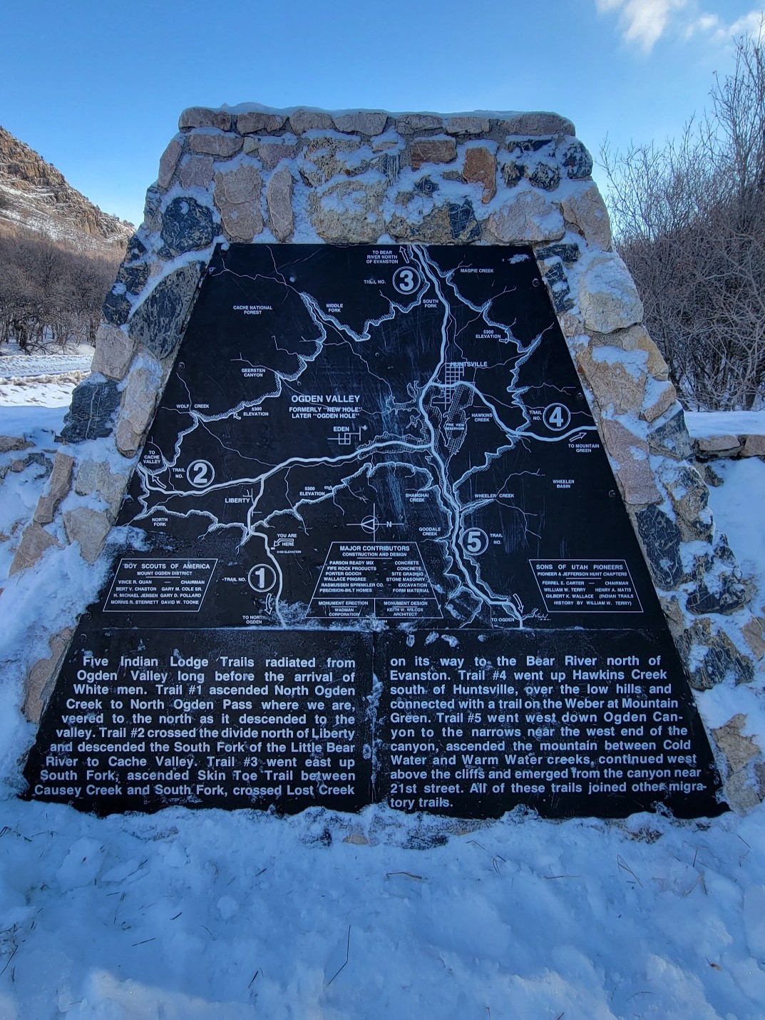
Five Indian Lodge Trails radiated from Ogden Valley long before the arrival of White men. Trail #1 ascended North Ogden Creek to North Ogden Pass where we are, veered to the North as it descended to the valley. Trail #2 crossed the divide north of Liberty and descended the South Fork of the Little Bear River to Cache Valley. Trail #3 went east up South Fork, ascended Skin Toe Trail between Causey Creek and South Fork, crossed Lost Creek on its way to the Bear River north of Evanston. Trail #4 went up Hawkins Creek south of Huntsville, over the low hills and connected with a trail on the Weber at Mountain Green. Trail #5 went west down Ogden Canyon to the narrows near the west end of the canyon, ascended the mountain between Cold Water and Warm Water creeks, continued west above the cliffs and emerged from the canyon near 21st street. All of these trails joined other migratory trails.
Historical Marker Text (3):

Pioneer Settlements:
Brigham Young learned much about the geography of the region near the Great Salt Lake from the writings of a few of the mountain men and from interviews with others. Soon after the arrival of the first company of Mormon Pioneers in the “valley” in July 1847 Brigham Young sent exploring parties north and south along the Indian trails west of the Wasatch Mountains to locate places for settlements. One of these parties contacted Mills Goodyear at Fort Buenaventura. In 1848 Brigham Young sent a party to explore the country around Bear Lake. The group went up Weber Canyon and took Trail #4 to Ogden Hole and then Trail #3 up South Fork on their way to Bear Lake. In 1854 Brigham Young sent an expedition over Trail #1 to find a shorter route to Fort Bridger for the settlers near Ogden so that they would not need to go via Salt Lake City. This expedition took the first wagon into the valley in (Ogden Hole). Charles F. Middleton wrote, “The first wagon that was taken into the valley was taken by hand of man. No mules or oxen hauled that vehicle. I steered the wagon. The wheels were locked, and my companions held onto the vehicle with ropes to prevent its breaking loose and dashing down the steep incline.) In 1856 Ogden Hole became a summer grazing area for cattle. The next year the first herd houses were built where Eden is located. The first permanent settlers arrived in 1858 and located near the herd houses. Huntsville and then Liberty were settled soon thereafter. A toll road through Ogden Canyon constructed in 1860 by Lorin Farr and Isaac Goodale, subsequently became the main route into Ogden Valley. Each summer for a number of years Indian bands passed through the valley over the old trails on their way to and from their hunting grounds. The Indians were not hostile for they had learned that they could get more food by bartering with leather goods and by the settlers being aware of their needs than by fighting.

Extended Research:
The Indian Trails Monument stands in the North Ogden Canyon and showcases a series of trails created by the movements of early Native American tribes, primarily the Northwestern band of Shoshone. The monument was placed by the Sons of Utah Pioneers and benefited from the research of people such as Mae Parry who was a very impactful Native American leader in Weber County, Utah.[1] Parry and others established a commitment to Native American history in the area, as it had largely been forgotten. The monument not only traces five Indian trails, but also gives a brief history of the early peoples who used these trails, such as Native Americans, early mountain men, and Mormon pioneers.
Long before white men arrived in the areas now known as Huntsville, Liberty, Eden, Ogden, and Cache Valley, Utah, they were inhabited by the Northwest band of Shoshone Indians. The Native Americans who lived there called the area “Opecarry,” which translated to “stick in the head.”[2] The Shoshone Indians were spread out around Utah and Idaho, however, the Indian Trails Monument in North Ogden Utah, specifically documents the trails established and used by the Northwestern band. These native peoples were nomadic hunters and gatherers who moved from place to place in search of water, edible vegetation, and wild game. They traveled with the seasons and learned over time the best places to obtain the greatest amounts of resources at the most opportune times. This took the Northwestern band into Northern and Eastern Nevada where they would harvest pine nuts, into southeastern Idaho where they found hot springs in the winter, and many other places throughout the year.[3]
Older Shoshone Indians used the term “So-So-Goi” to describe themselves, the term translates to “those that travel on foot.”[4] Before horses were introduced to the Northwestern band, this is exactly how they traveled, and from the young to the old, everyone was expected to pull their weight. The concept of sharing what one had, even with a stranger, was deeply engrained in the Northwestern band, and the concept of personal property did not exist. Helping neighbors and receiving help from neighbors was a way of survival for these early Indians, and therefore, they were constantly moving between different encampments of Shoshone and other nearby native groups for means of trading, socializing, and establishing kinship networks.
After years and years of travel between encampments, and areas known to harbor significant amounts of resources, the Shoshone established well-worn trails. These trails could be followed to get to several places in Northern Utah. The trails not only traversed large areas of Northern Utah, but they also connected to other migratory trails, and could be followed into places such as Fort Hall and other important sites in early Utah. As a result of their useability and effectiveness, early trappers in Utah also utilized these trails. The monument discusses the paths and trails early trappers such as Peter Skene Ogden, John C. Fremont, and Captain Howard Stansbury traversed in the area.
After coming into the area and having success trapping beaver, Peter Skene Ogden of the Hudson Bay Company would name this area “Ogden Hole.”[5] Some of these trails and expeditions even led John C. Fremont to the Great Salt Lake where he would discover the island that now bears his name and record other important scientific information about the Great Salt Lake. Many other early trappers and mountain men used these trails to move from area to area trapping and trading goods and interacting with Native tribes.[6]
The Mormon pioneers followed the same pattern and utilized the Native American trails for their own purposes. When the Mormons began arriving in the area, Chief Sagwitch led the Northwestern band of Shoshone. Contrary to the mountain men who often had good relationships with native tribes and integrated themselves into their culture and societies, the early Mormons often clashed with native tribes. When Chief Sagwitch learned of a group of Mormon pioneers coming their way, he went to meet their leader, Brigham Young, to offer peace and communication, as well as discuss stewardship over the land. Due to Brigham Young being ill, the Shoshone chief instead met with Heber C. Kimball who told him that the land belonged to the Lord, and the Mormons planned to cultivate and plant it. This is not what the Shoshone chief hoped to hear, but due to the peaceful and neighborly nature of the Northwestern band, Chief Sagwitch and his tribe continued to offer peace and assistance to the Mormon pioneers for years to come.[7]
The Mormon pioneers continued to use these trails for several reasons. As more saints continued to arrive in the Mormon settlements, farmland became scarce, and Brigham Young sent out scouts to find new land to settle. These scouts would undoubtably have used these well-worn trails as they moved through the area looking for promising ground. Furthermore, Brigham Young sent missionaries to find native tribes and assimilate them into Mormon society. Native Americans were thought to be descendants of the Lamanites, an important group of people in the Book of Mormon, which is the leading spiritual text of the Mormon faith. Therefore, missionaries would seek out native tribes to teach them of their importance to the Mormon faith and attempt to convert them. This was successful with many native tribes, especially the Northwestern band of Shoshone.[8] Many Shoshone converted and continued to share this land with their new neighbors.
The trails blazed by early Native Americans were important for many people occupying the area throughout the years. By traversing these trails, Native Americans were able to thrive in Northern Utah by migrating with the seasons and working with the land. The trails later made it significantly easier for mountain men to gain access to the frontier and trap animals and make early trading connections with native tribes. Furthermore, the Mormon pioneers would have had limited success moving throughout the area to settle and convert Native Americans had it not been for these trails that literally acted as a “golden brick rode” to the most resource rich areas, and native tribes.
The trails continue to be used today for recreational purposes and are favorite hiking trails for many residing in or near these areas. The history of these trails makes hiking them even more fascinating for many people, and through the work of the Sons of Utah Pioneers, and people such as Mae Parry and Darren Parry, author of The Bear River Massacre, the history of Native Americans and their homelands is being preserved and shared to the greater public.
For Further Reference:
Primary Sources:
Stansbury, Howard. An Expedition to the Valley of the Great Salt Lake of Utah. Philadelphia, PA: Lippincott, Grambo & CO, 1855.
Miller, David E. “Journal of Peter Skene Ogden; Snake Expedition, 1825.” Peter Skene Ogden’s Journal of his Expedition to Utah, 1825. Accessed March 1, 2022. https://user.mission.com/drudy/mtman/html/ogdenjrl.html.
Secondary Sources:
The Church of Jesus Christ of Latter-Day Saints. “Lamanite Identity.” Accessed March 2, 2022. https://www.churchofjesuschrist.org/study/history/topics/lamanite-identity?lang=eng.
North Ogden City. “About North Ogden.” Accessed February 18, 2022. https://www.northogdencity.com/community/page/about-north-ogden.
Parry, Darren. The Bear River Massacre: A Shoshone History. Salt Lake City, UT: Common Consent Press, 2019.
Roberts, Richard, and Richard W. Sadler. A History of Weber County. Salt Lake City, UT: Utah State Historical Society, 1997.
[1] Richard C. Roberts, and Richard W. Sadler, A History of Weber County (Salt Lake City, UT: Utah State Historical Society, 1997), 396.
[2] “About North Ogden,” North Ogden City, accessed February 19, 2022, https://www.northogdencity.com/community/page/about-north-ogden.
[3] Darren Parry, The Bear River Massacre: A Shoshone History (Salt Lake City, UT: Common Consent Press, 2019), 12.
[4] Parry, Bear River Massacre, 13.
[5] “About North Ogden,” North Ogden City, accessed February 19, 2022, https://www.northogdencity.com/community/page/about-north-ogden.
[6] Ibid, About North Ogden.
[7] Parry, Bear River Massacre, 28-29.
[8] “Lamanite Identity,” The Church of Jesus Christ of Latter-Day Saints, accessed February 27, 2022, https://www.churchofjesuschrist.org/study/history/topics/lamanite-identity?lang=eng.