The Kennedy Ditch was an early pioneer irrigation canal taken out of Parley’s Canyon stream near 17th East. The construction was achieved as a co-operative work project, and the new channel named after its first Water Master, Charles Kennedy, a Utah pioneer of 1848. The area thus brought under cultivation, covered 864 acres of small farm lands extending west of 13th East from near 21st South northward to 9th South, including this spot on Emerson Avenue. Emerson Camp Salt Lake County
Photo via Waymarking.com
Extended Research:
Early European explorers of Utah referred to the region as the “Great American Desert.” Most explorers believed the region was unsuitable for settlement, despite the fact that it had sustained Ute, Goshute, Paiute, and other tribes for thousands of years. In 1843, however, John Fremont published a report that suggested the western base of the Wasatch Mountains could be colonized by creating an irrigation system from mountain streams.1
When the Mormon pioneers arrived in the Salt Lake Valley in 1847, creating a planned system of irrigation canals was one of their first priorities. Mormon leader Brigham Young sent an advance party of able-bodied men to the Salt Lake Valley in July of 1847, with the goal of planting crops and building shelters before winter. This advance party laid out city blocks, farmland, and irrigation canals. Subsequent waves of Mormon pioneers expanded upon this planned, communal settlement pattern. City lots were divided into wards, which were supervised by bishops. These bishops oversaw the process of creating irrigation ditches for each ward.
Charles Kennedy. Image via churchofjesuschrist.org.
Communal ownership of water was an important innovation for the Mormon pioneers. In the East, laws commonly mandated that water could not be taken from streams unless it was returned without a reduction in volume. This was clearly impossible in the Salt Lake Valley’s semi-arid environment. Instead, Brigham Young declared that there would be “no private ownership” of water; dams and ditches were constructed by ward communities, rights to use the water depended on whether the land was being cultivated, and public authorities were appointed to supervise and apportion water use. This public authority was called the Water Master, who was appointed by the high council. One Water Master oversaw multiple wards.2
Charles Kennedy was the Water Master of the Kennedy Ditch and surrounding area. He joined the Church of Jesus Christ of Latter-day Saints in Nauvoo, Illinois in 1844 and was endowed in 1846. During the migration to Utah, Kennedy served as Commissary for 50 wagons, which meant he was in charge of distributing goods. He was part of the 1848 Brigham Young Company and settled in the Sugar House Ward, where he was appointed Water Master. Sometime between 1860 and 1867, Kennedy left the Mormon Church and moved to Missouri with two of his wives. He died in 1890.3
The missing historical marker
The Kennedy Ditch no longer exists. The current marker at the site of the Kennedy Ditch is missing. However, an online community called Waymarkers, where users log their visits to local landmarkers as a type of real-life scavenger hunt, provides clues about when this marker disappeared. Waymarkers documented the marker up until June 1, 2011; the next entry, on December 12, 2013, notes that the marker had been removed.4 It may be stored in the LDS chapel that currently occupies the site, but its whereabouts are uncertain.
Placed By: Daughters of the Utah Pioneers, no. 326
GPS Coordinates: N 40º37’603” W 111º48’000”
Historical Marker Text:
Daughters of Utah Pioneers No. 326 Erected 1966 COTTONWOOD PAPER MILL
In 1880 the Deseret News Corporation purchased a 28-acre millsite including water rights. With Henry Grow, architect and builder, the $150,000 structure, made of granite from nearby quarries with mortar of clay and stone grindings, took three years to erect. The 1860 paper machine from Sugarhouse Mill and some new machinery was installed; a 1500-ft. race brought water through the penstock to encased turbines. The plant could yield 5 tons of paper a day. Chas. J. Lambert, manager, sold to Granite Paper Mills Co. 1892; destroyed by fire 1893; restored 1927 as a recreational center. Central Company
Extended Research:
The first newspaper established in the Mountain West, the Deseret News, began publication in June of 1850. In order to reduce production costs, LDS leader Brigham Young appointed Thomas Howard, a paper maker from England, to construct a paper mill in Sugar House. The machinery for this mill was updated several times, with thrifty pioneers exchanging parts between beet sugar, iron working, and paper industries. In 1883, under the direction of Henry Grow, Deseret News Company received new paper machinery, and built Cottonwood Paper Mill to house the old machinery for use as a spare. The new mill was built using discarded granite from the construction of the Salt Lake Temple.
After the completion of the railroad, paper became cheaper to import, and the Deseret News sold Cottonwood Paper Mill to Granite Mills Paper Company in 1892. The mill was destroyed by fire in 1893.1
C. R. Savage. Deseret Paper Mill, Mouth of Cottonwood Canon Utah. L. Tom Perry Special Collections
Paper mills produce paper from waste cellulose fibers. In this case, the mill used cotton and linen rags. These rags were cooked and beaten to suspend the cellulose fibers in water. The fibers were collected on framed screens dipped in the water, and the water was removed by stacking frames between felt sheets. After the paper was dry, they were briefly soaked in gelatin or starch solutions, and dried again. This last step was known as “sizing” and prevented ink from feathering.2
Successful operation of the mill was a community endeavor. The mill required a constant supply of rags, which were collected by the Deseret News, public works programs, and church initiatives. In 1861, George Goddard was called on a three-year mission with the sole task of collecting rags for the mill. The calling “was a severe blow to [his] native pride,” but Goddard accepted the assignment. His rag collecting took him from Franklin, Idaho to Sanpete County, and involved preaching sermons on Sunday about rag collection. Goddard collected over 100,000 pounds of rags for the mill. The Women’s Relief Society took over rag collection in 1867 and organized regular rag drives.3
Following its destruction by fire in 1893, the mill remained unused until it was rebuilt in 1927 by J. B. Walker, a private citizen. The mill was transformed into an open-air dance hall, the Old Mill Club, and played a significant role in the local social scene. The club’s use was disrupted by World War II, when rationing increased food prices and military enrollment made mixed-sex activities, such as dancing, impractical. Following the end of the war, the social scene had shifted to drive-in movies, and the Old Mill Club never regained its former prominence, although it had rebranded itself as a “discotheque” by 1970.4 It has remained in the hands of the Walker family, with J. B. Walker’s grandson-in-law managing the property since 1987. The mill was condemned by Cottonwood Heights in 2005 due to earthquake building codes.5
Since its condemnation, the mill has been the target of repeated vandalism and theft. In 2011, thieves stole over $20,000 of copper wiring, and the mill’s historical marker was removed by the owner after he came upon thieves who had cut three of the plaque’s four bolts in order to steal it.6 Today, the mill is a study in contrasts. The crumbling, graffiti-laden building sits just up the road from a private gated community which bears its name and likeness. Residents tell ghost stories about the mill, and when the city of Cottonwood Heights commissioned a book on the community’s history, the mill graced the book’s cover. The mill’s owner envisions a future where the mill is rebuilt and used as an art gallery and dance hall.
Both markers placed by: The National Register of Historic Places, Division of State History
GPS Location: N 40° 45.755 W 111° 52.843
Historical Marker 1: No. S-28
Reads: First Church of Christ, Scientist, Salt Lake City: Organized July 17, 1891: Cornerstone laid June 4, 1898: Dedication November 27, 1898: Built of brick and kyune sandstone: Architect: W.E. Ware: First Christian Science Church established in Utah: Marker placed 1973
Marker placed by Division of State History Taken by Gabe Martinez
Historical Marker 2: No. N-120
Reads:First Church of Christ, Scientist, The First Church of Christ Scientist in Utah was organized in Salt Lake City on July 17, 1891. The church, designed by architect Walter E. Ware, was constructed of brick and kyune sandstone. Dedicated on November 27, 1898, the building is the oldest Christian Science Church in Utah and one of the oldest continuously Christian Science Churches in the world.
Marker placed by Division of State History Taken by Gabe Martinez
Extended Research:
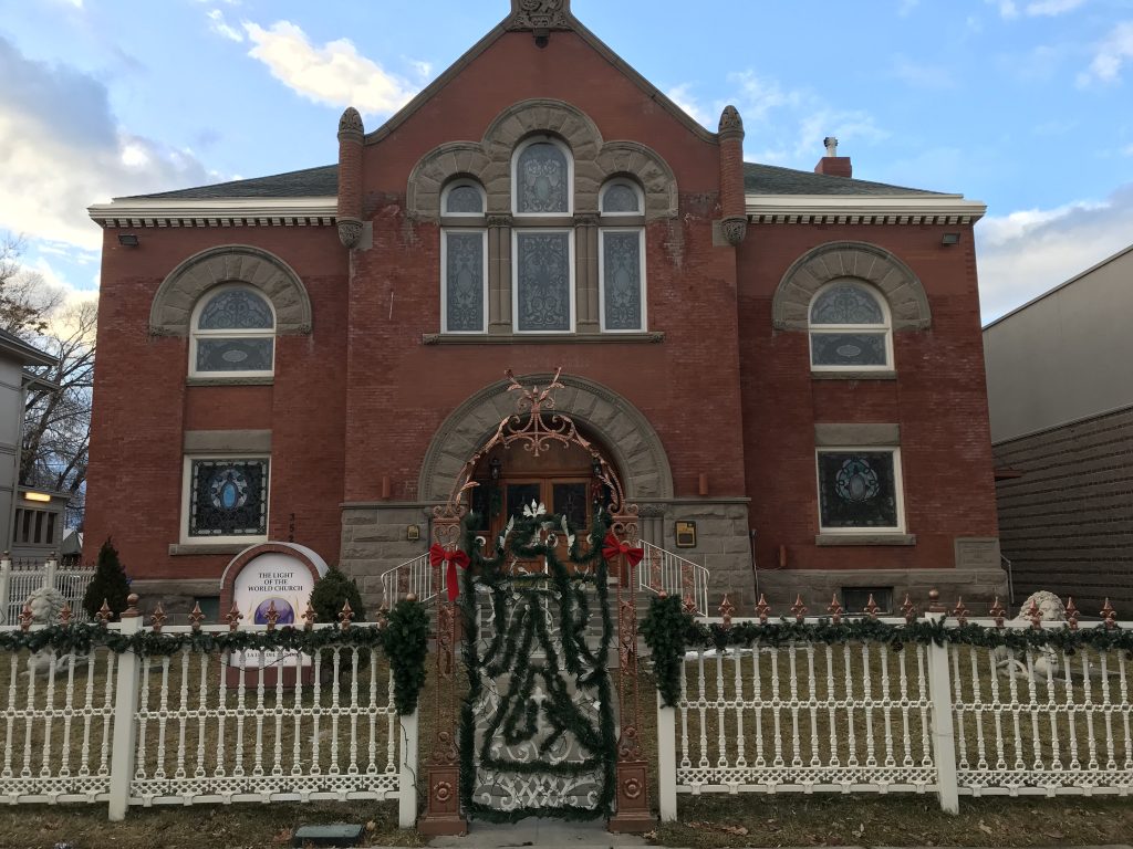
Front of the First Church of Christ Scientist building Taken by Gabe Martinez
This building upon its dedication on November 27, 1898 housed The First Church of Christ, Scientist. The First Church of Christ, Scientist began in 1866 in Boston Massachusetts. The church was founded by Mary Baker Eddy through a healing experience with The Bible after a severe slip and fall [1]. Upon establishing the church, years later in 1879, Eddy received a state charter to create the Massachusetts Metaphysical College where the doctrine of Christian Science was taught to missionaries [3]. One of her students, Mrs. M. A. Bagley graduated and brought the doctrine to Salt Lake City. On July 17, 1891 in the home of Mrs. M.A. Bagley along with 10 other individuals (8 women and 3 men total) The First Church of Christ, Scientist was formed in Salt Lake [3]. This building was fully funded by donations of the congregation and with the help of Walter E. Ware as the architect [4]. At the time of dedication, the church was able to seat 650 people but more than 1000 would show up to the services from all across the western frontier, with Mrs. M. A. Bagley leading the service [1]. Little is known about all the members of the congregation but stories of individual members do survive.
Second level of First Church of Christ, Scientist building Taken by Gabe Martinez
One of these members is Anna K. Craig. In 1892, Craig travelled to Utah to teach kindergarten at Brigham Young Academy. Along with being a devout practitioner of Christian Science, Craig was also a member of the Utah Sororis Club, a nineteenth-century club in Provo, and a member of the first Board of Directors of the Woman’s Council [8]. Craig was one of many great women of not only the Christian Science Church but also her community. She played an active role in pushing the state to implement kindergarten in the Utah educational system [8].
In 1869, several years before the dedication of the First Church of Christ Scientist building, the first non-Latter-day Saint worship building, The Church of the Good Samaritan, in Corinne, UT was constructed. Following the Good Samaritan, the first Catholic Church in Salt Lake City was built in 1871 [6]. After that, in 1883, a Baptist church joined the growing list of new religious buildings [7]. These along with many others like the First Church of Christ, Scientist were a part of a worship space revival in Utah as faith began to diversify due largely to an influx of immigrants from diverse religious traditions who arrived in the state from the 1880s to the 1920s.
Inside of First Church of Christ, Scientist building. Original organ pipes Taken by Gabe Martinez
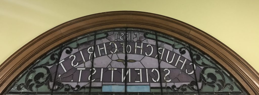
Most of the elaborate architecture and building features of the First Church of Christ, Scientist still stand today. For example the original organ and pipes remain but are not in use (pictured above). A majority of the wooden pews, including the ones on the second level, are original to the building (pictured above). All of the stained glass seen throughout the building is also original. Pictured below is the original stain glass window which reads “First Church of Christ Scientist” that can only be seen from the inside of the building.
Inside view of the front entrance stain glass of the First Church of Christ, Scientist building Taken by Gabe Martinez
This building now houses The Light of the World Church (La Luz Del Mundo). The Light of the World Church is not affiliated with the First Church of Christ, Scientist or Christian Science. In 2002, members of the First Church of Christ, Scientist sold the historic building largely due to changing demographics in the congregation and a move from downtown Salt Lake City to other areas of the state. The building then became home to Anthony’s Fine Art and Antiques. In 2006, The Light of the World Church purchased the building from Anthony’s.
In 2019, Christian Science churches in Utah have active congregations in the Salt Lake City area, Ogden, and Park City [5].
Primary Sources:
[1] Eddy, Mary Baker, 1821-1910, and Scientist First Church of Christ. The Christian Science Journal. Boston: The Christian Science Publishing Society
Secondary Sources:
[2] Johnson, Jeffery Ogden. “Lucretia Heywood Kimball (1856–1920): Pioneer in Utah’s Early Christian Science Movement.” Worth Their Salt Too: More Notable But Often Unnoted Women of Utah, edited by Colleen Whitley, University Press of Colorado, 2000, pp. 55–60. JSTOR, .http://www.jstor.org/stable/j.ctt4cgpjz.7
[3] Cannon II, Kenneth L. “Brigham Bicknell Young: Musical Christian Scientist.” Utah Historical Quarterly 50.2 (1982): 124-38.
Address: 5189 South State Street, Murray, UT 84107
Erected in 1960 by the Daughters of Utah Pioneers association.
Historical Marker Text : The Pony Express epoch began simultaneously April 3, 1860 with riders starting at St. Joseph, Missouri, and San Francisco, California. It was a 1966 mile journey and reduced the time of transmitting news across the country from approximately 21 to 10 days. Nearly one hundred stations were established. This spot marks the first station south of Salt Lake City. It was a small adobe building known as Travelers’ Rest. Here riders exchanged horses and received needed repairs, food, or lodging. With the inception of telegraph the pony express was abolished in October, 1861.
Extended Research
Distributing mail was a difficult and expensive task in the nineteenth century, especially from the eastern United States to the West. It was also a dangerous task due to the challenging terrain, harsh weather, and potential attacks from bandits. Designed to meet these challenges and overcome them, the United States contracted with a major American freight company, Russell, Majors, and Waddell, which established the Pony Express in April 1860. There were multiple express stations built between San Francisco, California and St. Joseph’s, Missouri. At these stations riders could get a fresh horse, rest, obtain food, and hurry on their way. It normally took more than three weeks by stagecoach to deliver the mail but the Pony Express made it possible to travel nearly 2,000 miles within ten days [1].
Although the Pony Express was very successful, there were still some dangers that the riders faced. There were some people who would try to steal the mail that the riders carried with them, sometimes resulting in violence. A Pony Express rider named George S. Stiers stated in one of his journal entries, that he encountered multiple men who tried to steal from him while on his way to deliver mail [2]. He worked as a mail carrier for three years but had to quit because the man who hired him didn’t want to be at fault for Stiers’ death during the delivery of mail.
Utah Territory was an important crossroads on the Pony Express route. “Salt Lake City was a major population center between the Missouri River and the West Coast”[5]. The Kansas based mail delivery firm, Russell, Majors, and Waddell created the Pony Express stations between St. Joseph’s, Missouri and Salt Lake City and from there to Sacramento.[4]. Most of the men who delivered the mail were young and some of them were from Salt Lake City. With Utah Territory’s population of around 40,000 people in 1860, the Pony Express carried many letters from the territory. In total, the Pony Express managed to deliver over 30,000 letters during the eighteen months that it was in business.
The Saddles that carried the mail
The Pony Express was successful in reducing the time it took to receive mail but it was not profitable. The completion of the transcontinental telegraph in October 1861 meant that the Pony Express was no longer needed. According to a journal entry by Captain J.H. Simpson, the telegraph used the same basic trail that the Pony Express had used and converted some of the Pony Express stations into telegraph stations [6].
Flyers requesting men to work in the Pony Express
The Pony Express should be remembered as an important advance in speeding the time it took to get news and information across the United States. At the time, nothing had ever been delivered so fast as the mail with the Pony Express. In the twenty first century, there are many methods to deliver things quickly like airplanes or cellphones. The fast delivery of the Pony Express was an important innovation for the nineteenth century like cell phones and airplanes are for people today. The Pony Express is also a symbol of the old West, especially an iconic man on a horse racing across the desert. It symbolizes masculinity, strength, and conquest and embodies many of the myths of the West.
The Pony Express Station in Murray, Utah was significant enough to get its own historical marker because it was one of the places where the riders could stop and relax. There were some stations that were dangerous due to their location, but the station in Murray was known for its safety and as a good place to rest. It was also the first station South of Salt Lake City to be established.
Simpson, J. H. Report of Explorations across the Great Basin of the Territory of Utah :for a Direct Wagon-Route from Camp Floyd to Genoa, in Carson Valley, in 1859 /by Captain J. H. Simpson. Made by Authority of the Secretary of War and under Instructions from Bvt. Brig. Gen. A. S. Johnston., 1876. https://archive.org/details/reportofexplorat00simp/page/n10
Fike, Richard E., and John W. Headley. The Pony Express Stations of Utah in Historical Perspective. Dept. of the Interior, Bureau of Land Management, 1979. URL: https://hdl.handle.net/2027/umn.31951002854172y
These historical markers were erected September 30, 1961 by the Daughters of Utah Pioneers (Central Company). It encompasses four markers.
GPS Coordinates (Latitude/Longitude):
40.7767625°, -111.89043469°
Transcript:
“This monument honors the Utah men who answered the call to protect the mail and telegraph lines along the continental route during the Civil War. April 25, 1862 Acting Governor of Utah, Frank Fuller, called for volunteers from the Nauvoo Legion. The next day twenty-four men under Col. Robert T. Burton left for their assignment. Two days later Brigham Young received an authorization from President Abraham Lincoln, through Secretary-of-War Stanton, for a company of cavalry to serve ninety days protecting the same route. One hundred and six men responded for duty under Captain Lot Smith. Later some Utah men joined the 3rd Regiment, California Volunteers, stationed at Fort Douglas, Oct. 1862-July 1866. Other pioneers served in the Civil War before coming to Utah.”
Transcript:
“Captain Lot Smith Company:
Joseph S. Rawlings, 1st Lt.
J. Q. Knowlton, 2nd Lt.
Richard H. Atwood, 1st Sgt.
James M. Barlow, 2nd Sgt.
Samuel H. W. Riter, Sgt.
Howard Spencer, Sgt.
Moses Thurston, Sgt.
John P. Wimmer, Sgt.
Andrew Bigler, Corp.
Wm. A. Bringhurst, Corp.
Hiram Clemons, Corp.
Joseph H. Felt, Corp.
John Hoagland, Corp.
Newton Myricn, Corp.
John Neff, Jr., Corp.
Seymore P. Young, Corp.
Moroni W. Alexander
William C. Allen
John Arrowsmith
Isaac Atkinson
William Bagley
Lachoneus Barnard
William H. Bess
John R. Bennion
Samuel R. Bennion
Henry Bird
Edwin Brown
Charles C. Burnham
John Cahoon
Theo J. Calkin
Thomas S. Caldwell
Francis R. Cantwell
Jesse J. Cherry
Peter Cornia
George Cotterell
Everet Covert
James H. Cragun
Charles Crismon Jr.
George W. Davidson
Albert Davis
Henry L. Dolton
Parley P. Draper
Josiah Eardley
Charles Evans”
Transcript:
“Captain Lot Smith Company:
Joseph A. Fisher
Wid Fuller
John Gibson
Moses W. Gibson
Joseph Goddard
William Grant
James Green
Edward F. M. Guest
Solomon Hale
Thomas H. Harris
John Helm
Samuel Hill
Ira N. Hinckley
James S. Hixson
Richard Howe
Louis A. Huffaker
Harvey C. Hullinger
James Imlay
Lars Jensen
Powell Johnson
Hiram Kimball, Jr.
Wm. J. Larkins
Thurston Larsen
Leander Lemmon
Daniel C. Lill
Wm. Longstrough
Thomas Lutz
William W. Lutz
William Lynch
Elijah Maxfield
Edwin Merrill
Reuben P. Miller
Mark Murphy
Daniel McNicol
Benjamin Neff
Edward A. Noble
Hiram G. North
Lewis Osborn
Hugh D. Park
Francis Platt
Lewis Polmantur
Francis Prince
Alfred Randall
Adelbert Rice”
Transcript:
“Captain Lot Smith Company:
Landon Rich
Wm. H. Rhodes
Alley S. Rose
James Sharp
Emerson D. Shurtleff
Harlon E. Simon
John Standiford
James H. Steed
Joseph J. Taylor
Joseph Terry
William Terry
John H. Walker
William H. Walton
E. Malin Weiler
James H. Wells
Bateman H. Williams
Ephrain H. Williams
Col. Robert T. Burton Company:
Heber P. Kimball, Lt.
Robert J. Golding, Sgt.
Joseph M. Simmons, Sgt.
John W. Woolley, Sgt.
Stephen Taylor, Corp.
James T. Allred
William Carlos
Mark Croxall
Lewis Grant
William J. Harris
Henry Heath
Richard D. Margetts
Orson P. Miles
Lewis N. Neeley
Samuel D. Serrine
Adam Sharp
George Spencer
Joshua Terry
George W. Thatcher
Lewis A. West
James Woods
Brigham Young, Jr.
John W. Young”
Utah and the Civil War Marker (2015), Utah Civil War Casualty:
This historical marker was erected on November 11, 2015 by the Daughters of the Utah Pioneers (International). It was added as part of the Utah and the Civil War Markers (1961).
GPS Coordinates (Latitude/Longitude):
40.7767625°, -111.89043469°
Transcript:
“Lieutenant Henry Wells Jackson (March 10, 1827- May 27, 1864), was the only Utah battle fatality of the Civil War and the first known Latter-Day Saint to be killed in a U.S. national conflict. Jackson marched in the Mormon Battalion, Company D, musician; panned for gold at Mormon Island (now Folsom Lake), California; and used gold to pay for his wedding. He and Eliza Ann Dibble were married in Salt Lake on February 3, 1850, by Brigham Young. Henry and Eliza started a family and helped establish settlements in Tooele Valley and San Bernardino, California. In 1858, Henry carried mail for George Chorpenning on the Overland Mail Route, a precursor to the Pony Express. Due to bad management, Henry was owed $1,300 in back pay for his mail service. He decided to go back East to try and collect the money. Payment was delayed, so Henry took employment as a wagon master and was ultimately captured by the Confederate Army and held as a prisoner for three months. He was later released in exchange for Confederate prisoners. Because of the way he was treated, he decided to fight for the Union. Henry enlisted with the First Regiment, District of Columbia, Volunteer Cavalry and was commissioned as a lieutenant due to his previous service in the Mormon Battalion. On May 8, 1864, Henry took part in the Battle of White Bridge near Jarrett’s Station, Virginia, and was shot. Due to infection, he died on May 27, 1864, leaving behind his wife and three children. Henry Wells Jackson is buried in Hampton National Cemetery and is remembered for his great sacrifice and love for family and country.”
Extended Research:
On April 12, 1861, the United States descended into a civil war, portrayed in the contemporary perception as a conflict between an industrial north and a slaveholding south. With this perception, it is often thought of as a war in the southern and eastern United States, excluding the American West from discussion about this uncivil bloodshed. While the American Civil War and its cruel battles remained mainly in the eastern portion of the country, people from its western territories and states participated in various manners. Utah’s role was small and limited, enacting its state militia for only a 90-day service before federal troops from California assumed responsibility. Members of the Nauvoo Legion were ordered to protect the telegraph lines and the overland trails. While the militia accomplished little in terms of warfare, the Nauvoo Legion’s participation helped provide a counterpoint to the American perception about members of the Church of Jesus Christ of Latter-day Saints’ loyalty to the United States.
Questions about Latter-day Saints shifted into doubts regarding the loyalty of Latter-day Saints to the Union. Prior to the Civil War, they were viewed as alien to the ideal American community, which was white and Protestant.[1] During the war, this perception became coupled with heavy suspicions that Latter-day Saints collaborated with the Confederates. For example, the governor of Nebraska Territory wrote of “Mormon emigrants,” who “sympathize warmly with the secessionists” and, “If they were disposed to make common cause with the secessionists in our own Territory and Missouri, the Indians also becoming their allies, they could easily exterminate the whole loyal population between the Missouri River and the Rocky Mountains before relief could be obtained from the Government.”[2] It was not enough that the group traveling through Nebraska were emigrants. They were “Mormon emigrants” who would ally with Native Americans, reflecting the idea that Latter-day Saints were not white through their associations and beliefs about Native Americans in their religious text, “The Book of Mormon.”[3] The religious people were contrary to the ideal American community, which suggested in the eyes of the public that they must be secessionists too. Perhaps, therefore, Simon Cameron reminded President Abraham Lincoln of the Utah War and recommended that another army should be sent to Utah to prevent violence by Latter-day Saints.[4] The “Mormon Problem” expressed before the war became a question of doubt about loyalty.
Latter-day Saint disloyalty came from their understanding of themselves as a persecuted people. In December 1861, Brigham Young, speaking in the Salt Lake Tabernacle, stated clearly that “never was a wickeder man than the President of the United States, and his associates are very wicked men.”[5] However, Brigham’s words were to express his disdain for the “Gentile” territorial leaders that lived in the state, believing them to have engaged in misconduct against the Latter-day Saints.[6] It reflected his desire for Utah statehood and the corresponding right for Latter-day Saints to govern themselves. Heber C. Kimball, an early Latter-day Saint leader, declared that while he did not pray for the destruction of the government of the United States, he knew that “dissolution, sorrow, weeping and distress are in store for the inhabitants of the United States, because of their conduct towards the people of God.”[7]
For Latter-day Saints, the Civil War thus brought a reliving of previous abuses and a reminder of the recent Utah War where the nation, in their eyes, turned against them once more. As a result, it was easy for Latter-day Saints to view the Civil War as God’s justice enacted against the United States when the war erupted. This is evident in an editorial likely penned by George Q. Cannon, which stated, “Already our boasted land of liberty… is deluged with blood, and will continue to be so until it has atoned for rejecting the Gospel and refusing to avenge the wrongs of our people, and for passively sanctioning the murder of God’s servants.”[8] The Civil War, in the early Latter-day Saint perspective, was justified for the murder of their prophet, Joseph Smith, as well as other abuses. These expressions of frustration, however, when viewed by the American public were seen as further evidence of LDS disloyalty.
Yet as much as Latter-day Saints expressed fiery indignation toward the United States for their “abuses,” there was a fair amount of conciliation and sympathy as well. Brigham Young did express sorrow for the people in the East.[9] Though angry at the United States federal government, Brigham affirmed Latter-day Saint loyalty to the country. He felt that it was better that his people submitted “to those things which are [unpleasant] than for us to do wrong” when asked if the Utah Territory would secede.[10] His first telegram to the United States reaffirmed Utah’s loyalty to the Constitution and the laws of the land.[11] To help affirm Latter-day Saint allegiance to the Union in the minds of the American people, he offered the Nauvoo Legion as an aid.
President Abraham Lincoln—tasked with the reunification of the country—knew that the survival of the United States rested on maintaining the loyalty of the states and territories remaining in the Union.[12] Part of Lincoln’s duty was to ensure communication lines with the western states and territories remained open. As workers built the transcontinental telegraph, Lincoln realized its importance. During its construction, he had the lines shifted more towards the north, putting the route through Salt Lake City.[13] Moving the route enabled the transcontinental telegraph line to remain open and free from interruptions. If this was not accomplished, communicating with the people in the West would prove long and tedious as it would more likely be done through messengers on horse. It would add further strains to an already stressed country.
It was not only President Lincoln who saw the vitality of communication with the West. Politicians, too, noted its importance. On May 1, 1861, Erastus Corning, an American politician, wrote a letter to Simon Cameron (the Secretary of War at the beginning of the American Civil War) stating:
I also think that it is of vital importance to the Government that the Hannibal and Saint Joseph Railroad be preserved to its owners, and that its free and uninterrupted use be maintained at all times and at all hazards. It furnishes the only accessible and speedy route by which the Government can communicate with Kansas, Nebraska, and Utah, or with its military posts along the Western and Northwestern frontier to the foot of the Rocky Mountains, and, if allowed to fall into and remain in the hands of an enemy, it is easy to see how difficult and well-nigh impossible in such an emergency it would be for the Government to preserve its Western Territories and military posts, for the danger to which they would be exposed would indeed be serious, and they could only be supported at immense expense and loss both of time and of means.[14]
However, the trouble did not come from Confederate sympathizers, but from Native Americans. For Native Americans, there was a desperate struggle to survive on dwindling resources as settlers encroached on their territory. Competition for natural resources taxed the natives as more settlers entered Utah.[15] The United States made treaties with the various tribes that comprised Utah territory in disadvantageous ways. They were written in English with terms not explained correctly and made with Native Americans who did not lead the tribe.[16] These treaties often faltered. Reservations were never maintained properly with living conditions proving difficult.[17] It pushed some Native American people to raid emigrant trains and cause general mayhem. For these reasons, Native Americans disrupted communications even prior to the war. During the war it proved alarming as Native Americans in the eastern United States sided with both the Union and the Confederates. There was a legitimate fear that native peoples in the West would join the Confederate cause and eliminate those loyal to the Union.
Feeding Native American peoples would not prove to be a solution. As reported by the Commissioner of Indian Affairs for the year 1862 in Utah, “To keep [Native Americans] from robbing the stations and committing depredations upon them, and upon the settlers and travelers, the largest expenditures were incurred for flour, wheat, and beef; but it was impossible, with the funds… to furnish them a constant and adequate supply.”[18] Resources were needed elsewhere as the war continued. The question of how to protect the communication lines was eventually solved by bringing forces to ensure Native Americans in the West did not cause issue for the embattled Union instead of using assets to keep peace. “The safe and speedy transportation of mails and of treasure over this route has now become of such vast importance to… the government, it is supposed the funds appropriated… cannot be devoted at the present time to a more useful purpose than the protection of the mail and telegraph lines.”[19] Perhaps surprisingly to the American public, Brigham Young offered Utah’s militia “to take care of all the Indians within [Utah’s] borders.”[20] Until other forces could assume responsibility, the Latter-day Saints had the duty to protect important communication lines, allowing them to prove their loyalty.
The opportunity for service came shortly after a year of the war had passed. The adjutant-general, Lorenzo Thomas, wrote to Brigham Young on April 28, 1862, allowing him to raise a company to protect the mail routes and telegraph lines. He wrote, “By express direction of the President of the United States you are hereby authorized to raise, arm, and equip one company of cavalry for ninety days’ service.”[21] Brigham Young acted immediately on this letter, ordering Daniel H. Wells, the Lieutenant-General of the Nauvoo Legion, to act on the telegram.[22] Daniel H. Wells raised the company with Lot Smith at the head. At the time, Colonel Robert T. Burton and his men were protecting mail routes in northern Utah.[23] As well, Robert T. Burton and his men were instructed “to protect Colonel Hooper, [General] Chauncey W. West, and Judge Kinney.”[24] Lot Smith and his men had different duties. He and his men were to be representatives of the Church of Jesus Christ of Latter-day Saints, having been admonished by Brigham Young to be “kind, forbearing, and righteous in all your acts.”[25] They marched to Fort Bridger in May and then to Independence Rock (both in Wyoming), improving the trail and noting the destruction of mail stations along the way.[26] In July, at Independence Rock, some of the men were instructed to apprehend deserters. Lieutenant J.Q Knowlton captured a horse thief (which resulted in a brief skirmish).[27] At the behest of Brigham Young, they contacted Chief Washakie of the Shoshones to ensure that he remained a friend to the Latter-day Saints.[28] Their last mission involved recovering animals from a Native American raid. On their return in August, a Private Donald McNichol “lost control of his horse” in the Snake River and was pulled under the river current, drowning.[29] Private McNichol’s death was the only loss that the Nauvoo Legion experienced. With their service completed, the United States passed the duty to protect Utah and the mail routes and telegraph lines to Colonel Patrick Edward Connor, a leader of a group of volunteers from California. Connor established Fort Douglas on the bench overlooking Salt Lake City and presided over federal forces in the territory for the duration of the Civil War.
Utah’s part in the Civil War was limited and small, but for the people involved, it meant a measure of self-preservation. For Native Americans, they sought to maintain their way of life as settlers encroached on their lands, diminishing viable resources. Options for survival changed; raiding and destroying became a method to uphold their rights as a people. As Latter-day Saints were perceived as alien before the conflict, this perception warped as the American public viewed them as secessionists that would consume the West. Latter-day Saint participation, through the Nauvoo Legion, achieved little in terms of warfare. Their service provided instead an opportunity to prove loyalty to a doubting Union and a way for Latter-day Saints to attempt to foster a positive self-image.
For Further Reference
Primary Resources:
Alford, Kenneth L. Utah and the American Civil War: The Written Record. Oklahoma: The Arthur H. Clark Company, 2017.
Corning, Erastus. Erastus Corning to Simon Cameron, May 1, 1861. In Utah and the American Civil War: The Written Record, edited by Alford, Kenneth L. Oklahoma: The Arthur H. Clark Company, 2017.
Dole, William P. “Report of the Commissioner of Indian Affairs.” H.exdoc.1/5. From Office of Indian Affairs, Department of Interior.
Paddock, Algernon. Algernon Paddock to Simon Cameron, June 24, 1861. In Utah and the American Civil War: The Written Record, edited by Alford, Kenneth L. Oklahoma: The Arthur H. Clark Company, 2017.
Thomas, Lorenzo. Lorenzo Thomas to Brigham Young, April 28, 1862. In Utah and the American Civil War: The Written Record, edited by Alford, Kenneth L. Oklahoma: The Arthur H. Clark Company, 2017.
Utah State Archives (Salt Lake City, Utah). Utah Territory Militia; Nauvoo Legion Correspondence, Orders and Reports, 1-2126. Film. Utah: Genealogical Society of Utah, 1966. Found in Family History Library.
Secondary Resources:
Alford, Kenneth L. Civil War Saints. Utah: Religious Studies Center, Brigham Young University, 2012.
Fluhman, J. Spencer. ‘A Peculiar People’: Anti-Mormonism and the Making of Religion in Nineteenth-Century America. Chapel Hill: The University of North Carolina Press, 2012.
Maxwell, John G. The Civil War Years in Utah: The Kingdom of God and the Territory That Did Not Fight. Norman: University of Oklahoma Press, 2016.
Reeve, Paul W. Religion of a Different Color: Race and the Mormon Struggle for Whiteness. New York: Oxford University Press, 2015.
[1] Spencer J. Fluhman, “A Peculiar People”: Anti-Mormonism and the Making of Religion in Nineteenth-Century America (Chapel Hill, 2012).
[2] Algernon Paddock to Simon Cameron, June 24, 1861, in Utah and the American Civil War: The Written Record, ed. Kenneth L. Alford (Norman, Oklahoma: The Arthur H. Clark Company, 2017), 87.
[3] Paul W. Reeve, Religion of a Different Color: Race and the Mormon Struggle for Whiteness (New York: Oxford University Press, 2015).
[4] Alford, Utah and the American Civil War: The Written Record.
[5] John Gary Maxwell, The Civil War Years in Utah: The Kingdom of God and the Territory That Did Not Fight (Norman: University of Oklahoma Press, 2016), 103.
[14] Erastus Corning to Simon Cameron, May 1, 1861, in Utah and the American Civil War: The Written Record, ed. Kenneth L. Alford (Norman, Oklahoma: The Arthur H. Clark Company, 2017), 80.
[21] Lorenzo Thomas to Brigham Young, April 28, 1862, in Utah and the American Civil War: The Written Record, ed. Kenneth L. Alford (Norman, Oklahoma: The Arthur H. Clark Company, 2017), 142.
[22] Utah State Archives (Salt Lake City, Utah), “Utah Territory Militia; Nauvoo Legion Correspondence, Orders and Reports, 1-2126” (Film, n.d.).
View of the Monument from the west side, near the corner of Center and Main. The Bountiful Tabernacle can be seen in the background.
Placed By: The
1992 Bountiful Area Centennial Committee.
GPS Coordinates: 40.889204,
-111.880969.
Historical Marker Text:
West Side Base: BOUNTIFUL CENTENNIAL MONUMENT – Sponsored by the 1992 Bountiful Area Centennial Committee. Artists – Goff Dowding, Rose Ann Peterson. Artistic Coordinator – Colleen L Parker. Monument erected by Bountiful Memorial Art Co. 1995.
North Side Base: CONTRIBUTORS – Bountiful Lions Club, The Bott’s Bountiful Memorial Art Co., Carr Printing Co. Est. 1890, Eastman & Co., Willey Ford-Willey Honda, Marion Don & Duff Willey, Ken Garff Bountiful Motors, Jack M. & Connie T. Bangerter, Have J. Barlow Family, Leo J. & Harriet W. Barlow, Lurae & Ronald Barlow, Milton A. & Gloria Barlow, Lee & Joyce Benard, Dallas & Margie Bradford, Lee W. Brown, Lloyd B. & Sandra J. M. Carr, Esra T. Clark, Mayor John Riley & Marco Mabey Cushing, Robert T. & Ida Lue Gardner Dewey, Delbert R. & Geneviere Duerden, Claudette & Dan R. Eastman, Dora D. & Legrand Flack, Albert S. Eddins, Keith Haight & Jassamine Smedley Ford, Don J. & La Ree Gine Family, David & Barbara Holt Family, David R. & Linda Hatch Irvine, Hatch & June Howard, Allen & Carlyn Jensen, Daniel T. & Rae Donna Jones, Jerry & Beth Lawrence, Richard & Evelyn Call Lemon, Mayor Bob & Lois Linnell, Rendell N. & Rachel Wilson Mabey, Harold D. & Lucile S. Muir, Laree & Kevin G. Olson, The “Swede” Olson Family, Don T. & Colleen L. Parker, Jerry Lorin & Evelyn Andersen Parkin, Jack W. & Lois T. Pickett, Richard S. & Geraldine T. Prows Family, John & Mary Stringham Rampton, Janet T. Schoenhals, Alvin Sessions Family, Orson Sessions Family, Roden G. & Naomi M. Shumway, Fred & Jeanene Stringham, Gregory & Jenny Skedros & Family, Dr. Juel E. & Dora V. Trowbridge, William V. & Kay F. Trowbridge, W. Brent & Ann Wilcox Family, Jerry L. & Lucile T. Vander Meyden.
South Side Base: ANCESTORS HONORED BY DESCENDANTS’ CONTRIBUTIONS – Israel Barlow, Thomas & Ann Kirkham Briggs, Heber Irvin & Marianna Zesiger Burningham, Anson Call & Wives: Mary Flint, Ann M. Bowen, Margaretta U. Clark, Emma Summers, Henrietta C. Williams, Ann Clark. David & Eliza Dittmore Call, Israel & Medora White Call, Alma & Kate Hardy, Thomas Arold & Sarah Wright Harrison, Clyde A. & Myrtle B. Hatch, Jospeph E. Hepworth, Joseph Holbrook, Mark C. & Sarah Ann Rampton Holbrook, Thomas & Mary Lowe Howard, Gov. Charles Rendell & Afton Rampton Mabey, Joseph Tomas & Sarah Lucretia Tolman Mabey, Russel Vincent Ord, Hyrum O. & Sylvia M. Pack, John & Elizabeth Wright Brown Parkin, Ivy Baker Priest, Henry Rampton, Patty Sessions, Perrigrine Sessions & Wives: Julia Ann Kilgore, Lucina Call, Mary Call, Fanny Emmorette Loveland, Sarah Crossley, Elizabeth Birdenow, Sarah Ann Bryson & Esther Mabey, Angus & Margaretta Waddoups Smedley, James Samuel & Alice Chase Smedley, Richard & Elizabeth Stringham, Amos Pease & Minerva Jones Stone, Newton & Emily Stone Tuttle, Judson Tolman, Jeremiah Willey, David & Martha Garrett Wiseman, Judson Tolman, Jeremiah Willey, David & Martha Garrett Wiseman, Gottlieb & Elizabeth Zesiger, Calvin Sessions Family, Richard & Sharon Ford.
East Side Base: Blank.
East Side Spire (facing Main Street): BOUNTIFUL CITY, INCORPORATED DECEMBER 14, 1892- Perrigrine Sessions drove his wagon north to this area in September of 1847. Here Sessions’ settlement had its beginning. The Second settlement in the territory of Utah. In 1855, thirty-seven years prior to incorporation as a city, the name was changed to Bountiful.
North Side Spire: EDUCATION – Education in this community was always important. As early as 1848 local pioneer children were taught by Hannah Holbrook in her wickiup school.
West Side Spire: BOUNTIFUL HARVESTS – Orchards and gardens were planted in abundance, supplying produce to local pioneer families. Bountiful harvests brought the development of the growers market, allowing widespread distribution of produce.
South Side Spire: PIONEER LIFE – Dances and drama, quilts and choirs, parades and brass bands, sleigh rides and horse races were all part of the culture and entertainment, so vital to pioneer life.
Extended Research:
Perrigrine Sessions, Founder of
Bountiful
East side of the monument.
Perrigrine Sessions was born in Maine on June 15, 1814. In 1847, he led one of the first LDS pioneer companies to Salt Lake City, and was in charge of herding the party’s 400 cattle.[1] After arriving in Salt Lake in July of 1847, Brigham Young instructed Sessions to form a party that would take cattle outside of the city where they could not harm the newly planted crops. Sessions acted as captain of a herding company that drove cattle north from July to August of 1847.
On August 12,
1847, Sessions dismissed the herding company to explore the land on their own.[2] After searching for
suitable grazing land for his own stock, in September, Sessions chose a
campsite near what is today 300 North and 200 West in Bountiful.[3] Sessions spent that winter at his camp with
his cattle. For his living quarters, Sessions built a dugout by digging into an
embankment and attaching his wagon to it.[4] Sessions’ initial campsite
laid the groundwork for Sessions Settlement.
In the spring of 1848, Sessions gave up cattle herding for farming. He established the first farm in the settlement and built one of the settlement’s first permanent homes.[5] Sessions hosted religious gatherings in his house until the city could build larger venues, like the Bountiful Tabernacle in 1863.
Name of Settlement Changed to
Bountiful
The early pioneers referred to the settlement strictly as Sessions Settlement for about a year. In 1849, the LDS Church divided it into tithing wards. The North Mill Creek Canyon Ward covered the settlement area, so many residents began referring to it by its ward name. In 1854, the Bishop of the ward was John Stoker, and after the residents named the settlement’s post office after him, they used the name Stoker for the settlement. In 1855, Bishop Stoker proposed the name Bountiful, after a city found in the Book of Mormon, an LDS book of scripture. From then on, the people called the settlement Bountiful, and later the town council incorporated it as a city under that name on December 28, 1892.[6]
Hannah Holbrook, Bountiful’s First School Teacher
North side of the monument.
Hannah Holbrook, maiden name Hannah Flint, was born on July 18, 1806, in Stanton, Vermont. In 1831, she moved from Vermont to Ohio with her parents, Rufus Flint and Hannah Hawes. It was there that she and her family converted to the Church of Jesus Christ of Latter-day Saints. In 1838, when the Church called for members to immigrate to Missouri, she took the trip with her sister Mary Flint and brother-in-law Anson Call. She again immigrated with them and the Church to Nauvoo Illinois, where she earned a living by teaching.[7]
Hannah Holbrook married Joseph Holbrook in Nauvoo in 1843, and the two of them trekked to Utah in 1848. In October, Holbrook’s husband travelled through Tooele and Davis counties to find suitable farmland for his family. He chose a 126 acre section of land on the outskirts of Sessions Settlement. There, he constructed a log home that he did not complete until 1850.[8]
Holbrook did not wait for her husband’s improvements to the land before she began teaching. As early as 1848 she taught the children of Sessions Settlement out of a “school made of bulrushes.”[9] She persevered through winter storms, isolated conditions on the edge of town, and a cramped schoolhouse to provide an education to settlers’ children.
In 1854, Sessions
Settlement formed a committee which assessed a school tax and constructed a
large adobe schoolhouse located at about 400 North and 200 West.[10] Holbrook was the first
teacher to utilize the schoolhouse and “by the end of 1855 she had 50
students.”[11]
Joseph Holbrook praised his wife in his journal, saying, “she is one of the
most capable teachers and the most experienced in the country and keeps a good
school.”[12]
Today, Davis County has an elementary school named after her.
Bountiful Agriculture
West side of the monument.
The initial settlers in Bountiful found rich soil and mountain streams that facilitated profitable farming. In Bountiful, the average farms spanned 60 to 120 acres.[13] Farmers who could avoid the menacing cricket invasions enjoyed successful growing seasons in Bountiful’s relatively mild climate. With large farms in an ideal location, settlers produced impressive crop yields, which “averaged out per household at eighty-eight bushels of wheat, forty-six bushels of potatoes, sixteen bushels of oats, and fourteen bushels of corn. Farms also produced about 6 tons of hay ‘per harvester.’”[14] By 1852, Heber C. Kimball, one of the 12 apostles of the LDS Church, opened Bountiful’s first gristmill to serve the demand for local grain processing.[15]
Farmers grew more
than staple crops. Anson Call brought sugar cane to the settlement. One farmer,
Newton Tuttle, produced 152 gallons of molasses from his plot of sugar cane.
Newton Tuttle also led the fruit drying industry. He established a small nursery
that provided for Bountiful’s many orchards. Families who grew fruit dried it
and took it to market to barter for everyday supplies like clothing.[16] In addition to sweets,
many women kept kitchen gardens, which, aside from the traditional cooking
vegetables, grew medicinal herbs that they used to administer healthcare
services throughout the community.[17] Indeed, Bountiful’s
settlers enjoyed a wide variety of tasty and healthful produce.
In addition to
excellent produce, farmers kept livestock. To keep cattle out of unfenced
fields, the community came together to establish common grazing grounds. With
common grounds, the settlement needed fewer herdsmen to keep cattle in place.
In addition to cattle, many of the original settlers experimented with sheep
farming, and most families kept their own dairy cow, chickens, and sometimes
pigs. Perrigrine Sessions built a livestock pound to keep escaped animals. If
livestock escaped the farm, volunteer pound keepers captured the animals and
placed them in the community pound.[18] Livestock keeping methods
show the cooperative spirit of pioneers.
Early Bountiful
Culture
South side of the monument.
Pioneer
entertainment relied on community participation. Before the School House or
Rock Hall were built, Perrigrine Session’s house was the largest structure
available. He hosted dances for the town. Couples attending the dances paid a
small admission fee in cash or in kind in order to cover the cost of the
musicians.[19]
As the city grew, youth began to participate in their own dances, supervised by
local clergy.[20]
Joseph Holbrook, Hannah Holbrook’s husband, built the Rock Hall, which
frequently hosted LDS choirs, one of the most common forms of entertainment,
and also served as a venue for social gatherings. Social gatherings regularly
centered on adult education, such as intellectual debates and political,
academic, or religious talks.[21]
The town
commemorated summer holidays with raucous celebrations that often included
fireworks, gun salutes, cannons, boisterous brass bands, and sporting events
like baseball games and footraces.[22] James Weight founded
Bountiful’s own brass band in 1863 using contributions from townsfolk to buy
instruments.[23]
This band played for events like Pioneer Day on the 24th of July,
which was Bountiful’s largest holiday. Pioneer day always included a parade,
and as tribute to Bountiful’s abundant produce, participants often decorated
their wagon floats with ripe fruit.[24]
Bountiful
residents celebrated winter holidays, like Thanksgiving, Christmas, and New
Year’s, with horse races. The horses raced down an unofficial track, often the
main road that stretched across the north of the town, breathlessly trampling
the tracks left by winter sleighs.[25]
Further Reading:
Primary Sources:
Perrigrine Sessions
Emigrating Company Journal, Church History
Library, The Church of Jesus Christ of Latter-day Saints., Call Number: MS 256.
Joseph
Holbrook Autobiography and Journal, Church
History Library, The Church of Jesus Christ of Latter-day Saints., Call Number: MS 21793.
Secondary Sources:
Foy, Leslie. The City of Bountiful: Utah’s Second Settlement from Pioneers to
Present. Bountiful: Horizon Publishers, 1975.
Leonard, Glen. A History of Davis County. Salt Lake City: Utah State Historical
Society, 1999.
Mabey, Joseph Thomas.
Our Father’s House. Salt Lake City:
Beverly Craftsmen, 1947
[1]
Leslie Foy, The City of Bountiful,
(Bountiful: Horizon Publishers, 1975), 9.
In 1848 Eric G. M. Hogan, a Norwegian immigrant and the first South Bountiful settler, built a cabin for his wife Halga and their children on the site located approximately 934 West and 1500 South. A second cabin, constructed in 1857 for his wife Ingeborg was located a block east of the first home. In 1862 Mr. Hogan married Hannah Nielson an expert carpet weaver. While she wove, Ingeborg cared for Hannah’s five children. This family of eight lived in the house for seventeen years. In 1934 Hyrum Hogan, eldest son of Eric and Hannah and his wife Margaret, presented this cabin to the Eutaw Camp of the D. U. P. who moved it to the grounds of the South Bountiful Church. Fire destroyed the Church in 1975 and the Cabin was moved to the City Park. Here it stands as a memorial to the Hogan Family and all the pioneers who came to this area.
Plaque B
In 1848 Eric G. M. Hogan and Family settled in South Bountiful. In 1858, he built this cabin of native logs for wife Ingeborg. The slab roof was fastened with wooden pegs a ladder in corner served an upper room. Hannah joined the family in 1882, whose five children were born here. After seventeen years a larger home was built and the Cabin became a granary. Given to D.U.P. by Hyrum and Margaret Hogan for a relic hall. Moved to this location in 1978.
The Story of the Cabin
In Woods Cross, Utah, at 1500 South just East of Main Street is a park. This park is not like all of the other parks in Utah. Like any other park it has two playgrounds for children to play on, swing sets for high flying adventures, courts for pickle ball and basketball and a baseball diamond in the back. Unlike most parks, however, there is a little log cabin that sits near the street on the North side of the park. This log cabin was built by Eric Gautesson Midtboen Hogan in 1857.
Erick G. M. Hogan
Erik Gautesen Midtboen Haugen, was born in Norway on June 23, 1802. After the death of his first wife, Kari Sondresen who died in childbirth, he married Helge Knudsen in 1829. Together they had five children and lived a good life, until Haugen heard people talking about America and the life that they could have there. Haugen felt the draw of a better living than he had in Norway. They weren’t poor but they weren’t wealthy. Hogan felt that the move would improve their status and wanted to move straight away. Helge took a few years to be swayed on moving, Hogan told her, “well, I am going; we will separate; I will take two of the children; you may take two and we will cast lots for the fifth one.”[1] This comment swayed Helge to agree and together with their five children the family left for America in 1837 where he changed the spelling of his name to Eric G. M. Hogan.
The Hogan family had many hardships on their journey to a new world. Their third child, four-year-old daughter Heige died at sea. When they arrived in America the pouch that held their money went overboard, and though they recovered some money they still lost $200. At first, they stayed in Chicago where they lost another child, three-year-old Margit. They then moved to Ottawa, Illinois where other Norwegian families lived. There, a sixth child was born who they named Harriet. It was also in Ottawa in 1843 that the family converted to the Church of Jesus Christ of Latter day Saints and moved to Nauvoo to be with the saints there. They had three more children named Elizabeth, Margaret, and Regena. On April 17, 1846 they moved West with the rest of the members of the Church of Jesus Christ of Latter-Day Saints. They arrived in the Salt Lake Valley in September 1848 after one more child, their tenth was born and Helge, became seriously ill.
Ingeborg Maria Jensen Hogan
Erick Hogan found some land north of Salt Lake City and settled his family near a nice stream. Later this area would be known as South Bountiful and Woods Cross. In 1858 he became a polygamist when he married Ingeborg Maria Jensen. In 1862 he married a third living wife, Hannah Nilsson. Ingeborg had no children and Hannah had five. Together the second and third wives lived in the cabin that Erick built in 1857 for Ingeborg. In 1878 during the diphtheria epidemic, three of Hannah’s children died.
Hannah Nilsson Hogan
The cabin as Hogan built it in 1857 was described as, ‘a house with one room downstairs and one up, with a slab roof and an adobe chimney.’ [2] It was built at a different location, on about 934 West and 1500 South. A second room was built off the main room for Hannah to do her weaving.[3] After it was no longer used as living quarters, the Hogan Family used it to hold hay or injured animals. In February 1934 in a Daughter’s of the Utah Pioneers meeting in Bountiful Utah, Hannah and Erick Hogan’s first born son Hyrum announced that he and his wife “would present the camp with their log cabin.”[4]
Hogan Cabin being moved
When the DUP received the cabin, they loaded it onto a tractor and took it to the East side of the Church grounds. [5] They relocated the cabin to the Latter-day Saint chapel about 15,000 feet away from where the meetings of the DUP’s Eutaw Camp were being held. It was chosen to ‘be preserved as a relic hall and as a memorial to the sturdy faithful pioneers of the community.’[6] The DUP also said that ‘it will be used as a meeting place for the members of the DUP camp and also to house pioneer relics.’ [7] There are now several artifacts that are housed in the cabin which were donated by members of the community and the DUP, however only three of those artifacts once belonged to the Hogan family.
The Hogan Cabin being moved.
The DUP used the building to hold meetings and socials. In March of 1975 a fire engulfed the Latter-day Saint Chapel but luckily left the cabin untouched. After the fire was extinguished, the cabin looked like “a tiny ghost house against the blackened ruins of the church.”[8] A group of people, including members of the DUP and community, decided then that the cabin needed a better home and so, the cabin was moved again by the DUP, this time across the street where the park is. They carefully moved the cabin and then renovation and restorations began. They filled in the missing and broken panels of wood with new ones, and someone was hired to build a new fireplace for the cabin, making it no longer the simple adobe style that was first there.[9]
The Hogan Cabin being put on a concrete slab at Hogan Park in Woods Cross.
On August 9, 1976 people in the community and members of the DUP gathered at Hogan Park to dedicate the cabin as a relic of the past. Members of the community and the DUP gathered in attendance. The DUP organized a program with musical numbers and speakers who talked about the history of the cabin and its inhabits along with its restoration and the journey the cabin had go take to get to this spot. A plaque by the cabin was unvalued for the bicentennial celebration of Eric Hogan arriving in the South Bountiful area. There were about 250 people present on the cool summer evening. All in attendances were invited to linger and view the cabin while the DUP served refreshments.
Photo of Helge Hogan and the flower neck piece she made and brought across the planes
The South facing wall and where the second room was attached .
East facing wall and the new fireplace.
North-West corner
Now visitors who which to see the interior of the cabin can do so by appointment only by calling the Woods Cross City Hall. Visitors will note that the floor of the second room has been removed, exposing the ceiling. There are horizontal beams placed where the ceiling would be to help with the integrity of the cabin. The DUP member in charge invites visitors inside the small cabin and then they are free to look around for a while at all of the artifacts. She talks about the Hogan family and some of the things that they endured to reach South Bountiful. Then she takes them on a short history of the development of Woods Cross. The DUP envisioned this cabin to “stand as a memorial to all our pioneer forefathers and may we appreciate our heritage and live so that they will be proud of us.” [10]
GPS coordinates: 40.9142194 degrees north, -111.3975917 degrees west
Photo taken January 29th, 2019 by Brianna Siddoway
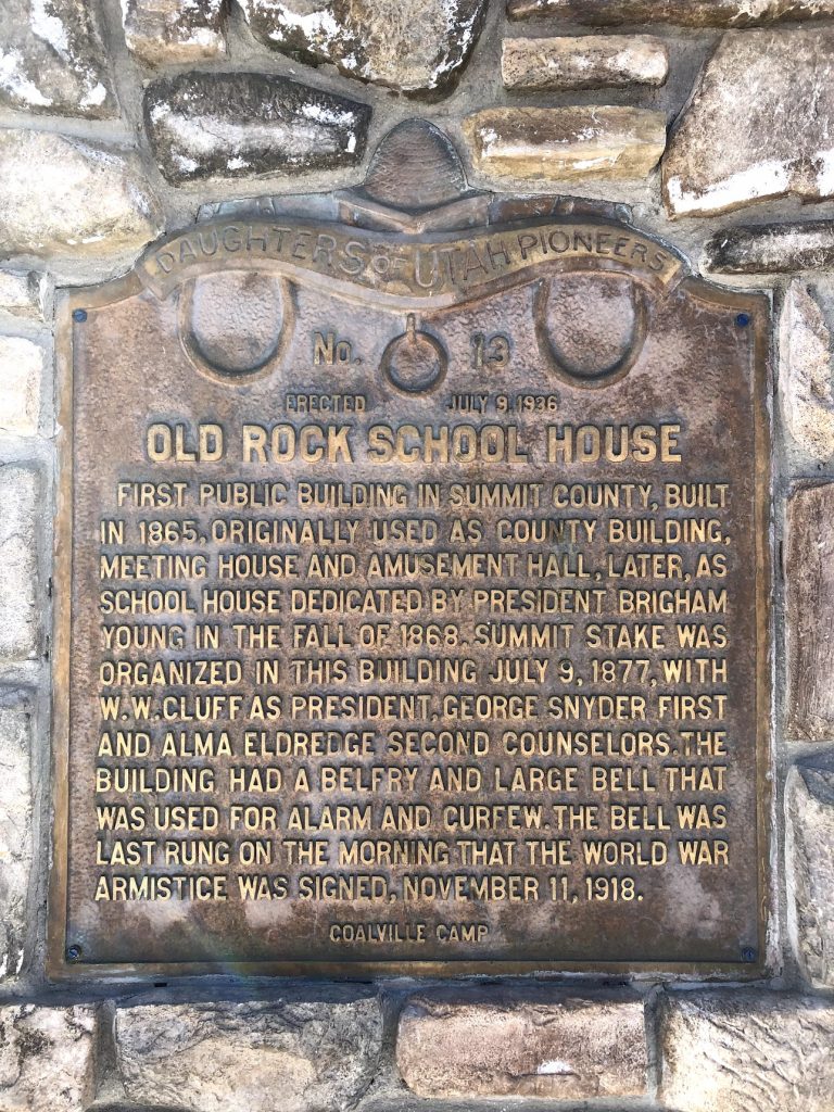
Historical Marker Text:
First public building in Summit County, built in 1865, originally used as county building, meeting house and amusement hall, later, as school house dedicated by President Brigham Young in the fall of 1868. Summit Stake was organized in this building July 9 1877, with W.W. Cluff as President, George Snyder first and Alma Eldredge second counselors. The building had a belfry and large bell that was used for alarm and curfew. The bell was last rung on the morning that the World War Armistice was signed, November 11, 1918.”
Photo taken January 29th, 2019 by Brianna Siddoway
Photo taken January 29th, 2019 by Brianna Siddoway
Extended Research:
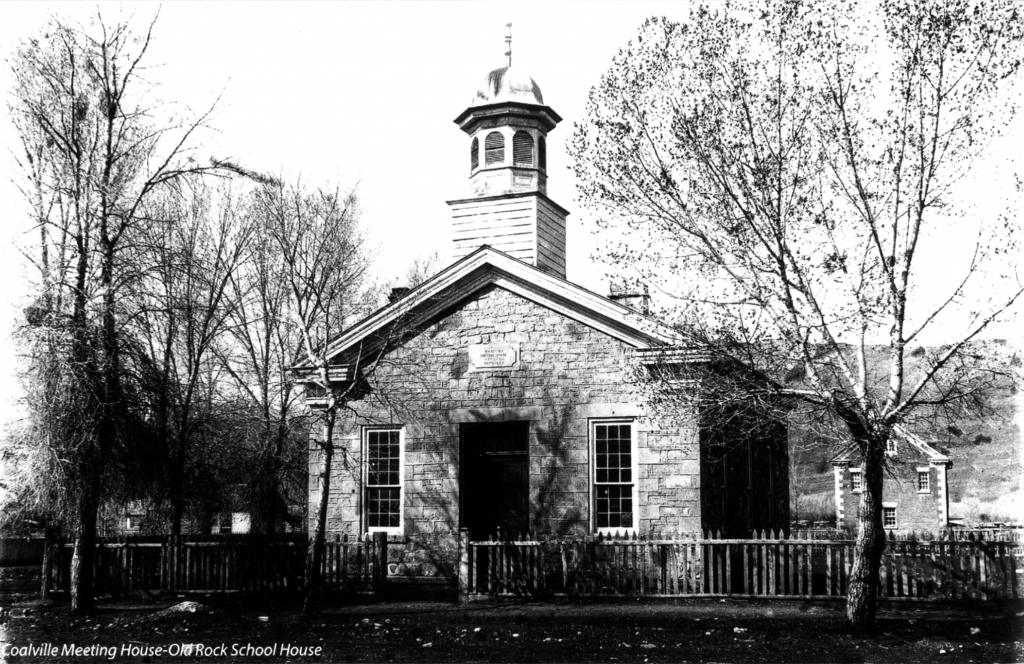
In its early years as a settlement, the people of Coalville used a small log cabin for a school and meeting house for religious services. From 1864 to 1865 the community banded together to build a new, larger building to accommodate their growing numbers. Settlers donated whatever labor, time, and supplies they could spare to the effort.[1] Fredrick Wilde owned land in Coalville and wanted a church to be built there. He and many others helped to build what became a regional church building for members of the Church of Jesus Christ of Latter-day Saints who lived in the Summit County area, also called the Summit Stake House.[2]
Near the chosen location for the new building was a ledge of stone which the builders decided to use in constructing their new meeting house. Thus, the finished structure came to be known as the “Rock Church,” “Rock Chapel,” and “Rock School House.” Lumber, however, was not as readily available and had to be brought from Sawmill Canyon, approximately 10 miles away, up Echo Canyon. One settler, William H. Smith, donated ox teams to the effort of hauling stone to the site and to collecting logs from canyons while other settlers donated labor at the saw mill.[3]
Photographer George Beard 1855 – 1944 Photo provided by NaVee Vernon, Summit County Historian, January 2019
When the building was completed in 1865, the community began to use it as a church and school house. A small, one room structure, the Rock School House was built with a belfry, which housed the bell used to call school children to their lessons. The bell was also used as a warning sign to the community, in which cases the building was used as a refuge. The Rock Church was further used as a social and amusement hall for parties and dances. It sometimes became a government center for the county as well, where “laws and rules were formulated [to] govern the people.”[4]
In September 1869, a few years after its completion, Brigham Young, President of the Church of Jesus Christ of Latter-day Saints, dedicated the building. On September 24th the Deseret Evening News reported that at the time it was being built, many thought it would be too large, but after it was finished, due to population increase, the community had already outgrown its Rock Church. “It is a chaste, elegant building,” the News reported, “beautifully finished, and it is a credit to the place.” During his trip to dedicate the building, President Young counselled the Bishop of Summit and Morgan counties, W.W. Cluff, “to take steps to build a larger meeting house… and when done to use the present building for a schoolhouse.”[5]
Rock Chapel as it stands in Lagoon’s Pioneer Village. Taken June 13th, 2011; found here.
The bell was last rung on November 11, 1918, otherwise known as Armistice Day, when the bell signaled the end of World War I. The small building continued to be used as a social hall and later as a seminary for the Church of Jesus Christ of Latter-day Saints until 1975 when it was sold to Lagoon’s Pioneer Village where it stands today with its original furniture on display.[6]
Rock Chapel Sign, on site in Lagoon’s Pioneer Village. Taken June 13th, 2011; found here.
Rock Chapel Sign Text:
The Pioneer Village Little Rock Chapel has as fascinating a history as any building in Utah. Originally located on Main Street in Coalville, it was constructed in 1863 as a fort against the Indians, and was used in more than one attack. When the Indians became friendlier, the building became a courthouse with the jail attached to it. Later as the area grew, it was turned into a schoolhouse and became the center for social activities in the Coalville area. Finally, in 1869, the chapel was dedicated by Brigham Young as an LDS church. It retained its importance as a meeting place for both social and political activities in the community. Constructed of hand-drilled, hand-cut blocks of Summit County sandstone, the chapel contains the original pews, pot-bellied stove and lectern. Paneling and pews were wood-grained to simulate hardwoods. This was commonly done through this period, when only softwood was available and the appearance of hardwood was more desirable. This church is a unique and lovely reminder of Utah pioneer heritage.
[1] Rhea M. Bagnell, “The Old Rock School House in Coalville”, Personal History. Provided by Summit County historian NaVee Vernon.
[6] Walter Lee, “The Old Rock School House,” Issue brief, compiled by Mary Andersen, Daughters of the Utah Pioneers. Provided by Summit County historian NaVee Vernon.
For Further Reference:
Primary Sources:
Bagnell, Rhea M. “The Old Rock School House in Coalville”. Personal History. Provided by Summit County historian NaVee Vernon.
Lee, Walter. The Old Rock School House. Issue brief. Compiled by Mary Andersen. Daughters of the Utah Pioneers. Provided by Summit County historian NaVee Vernon.
Coalville School Bell and the Old Rock School House. Daughters of The Utah Pioneers. Provided by Summit County historian NaVee Vernon.
Historical Marker Text: “The Assembly Hall, constructed of granite stone left over from the building of the temple, was completed in 1880. It is a place of public worship, in which visitors are welcome. Although the building is used mainly for conferences of the Latter-day Saints congregations located in Salt Lake City and for other Church meetings, it is also available for various cultural and civic functions. The Gothic Revival structures is 68 feet wide and 120 feet long and the center tower is 130 feet high. The auditorium holds almost 2,000 people, with choir seats for 100. The truncated spires were originally chimneys.”
Extended Research:
“[A]t a priesthood meeting of the Salt Lake Stake, held August 11, 1877, President B. Young proposed to pull down the Old Tabernacle, and build a new one to accommodate about 3,000 people.[1]” Young would pass away eighteen days after this meeting and would not live to see the beginning of construction on the beautiful building which resulted from his proposal. Leaders of the Salt Lake Stake of the Church of Jesus Christ of Latter-day Saints would take Young’s direction and oversee the process of construction on the Salt Lake Assembly Hall.
The Assembly Hall was designed by architect Obed Taylor who oversaw the building project after being commissioned. The building was constructed on the southwest corner of Temple Square directly south of the Tabernacle. The architecture is heavily modeled after Victorian Gothic influences. “Rough Granite walls are placed in cruciform style” which resembles many gothic cathedrals in Europe.[2] The roof is marked by twenty-four spires that give unique distinction to the edifice relative to the other buildings on Temple Square. Another unique feature is the inclusion of Stars of David high above each entrance.
Using mostly discarded granite stone from the construction of the Salt Lake Temple, builder Henry Grow completed construction in 1882 at a total cost of $90,000. During the first two years of construction the building was often referred to as the new tabernacle but was officially named “The Salt Lake Assembly Hall” in 1879 by then LDS church president John Taylor in order to distinguish between it and the already existing domed Tabernacle to the north. The first regional meetings of the LDS Church known as stake conferences were held in the Assembly Hall in January of 1880 while the building was still under construction.[3]
Figure 1: Salt Lake Assembly Hall under construction, circa 1880[4]
The Assembly Hall was officially dedicated in 1882 under the direction of President Joseph F. Smith, a member of the First Presidency of the Church of Jesus Christ of Latter-day Saints. Upon its completion, the Assembly Hall became the second permanent structure still standing on Temple Square, the Tabernacle having been finished in 1867. It served as an alternate location for many Church meetings including General Conference of the Church.[5] Various meetings and gatherings have been held within the quarry walls of the Assembly Hall. Funerals, concerts, local and regional church meetings, and various political gatherings have all been held in the Hall.
One gathering of significant historical importance was a gathering of women in 1889 that resulted in the formation of the Utah Women Suffrage Association. “When Mormon suffrage leaders of Utah, such as Emmeline B. Wells, called for a meeting of suffragists to be held in the Salt Lake Assembly Hall on January 10, 1889, they were soon overwhelmed by the number of women in attendance…which sought to restore the franchise to the women of Utah who had lost the vote two years prior as a result of the Edmunds-Tucker Act.[6]” In part due to the efforts of the Women’s Suffrage Association voting rights were restored to women in 1896 when Utah achieved statehood.[7] The Assembly Hall thus not only serves as a center of spiritual and religious importance to the Latter-Day Saints but also a symbol of the state of Utah’s diverse and powerful history.
Figure 2 Interior
In 1979, nearly a century after its initial dedication, the Church of Jesus Christ of Latter-Day Saints commissioned a massive renovation of the structure in order to preserve the historically significant edifice. The extensive three-year project restored the Assembly Hall to its original beauty while strengthening the building to comply with modern safety standards. The project architect who led the renovation efforts stated, “Anticipating this undertaking, I tried to appreciate the attitudes of our pioneer forefathers, and really comprehend the deep love and devotion they had in making this building a monument—not to themselves, but to the Church and to the Lord.” [8] The painstaking architecture and immense amount of labor needed to construct this building shows that the Mormon pioneers viewed its construction as a demonstration of their devotion to God. Emil B. Fetzer church architect at the time of the renovation project shared his thoughts about the historical significance of the Assembly Hall. “The Assembly Hall is one of the very precious buildings of the Church; it’s a real treasure. In all the designing and work we’ve done on it, we have tried to keep in mind that this is a Church building of extreme importance and have tried to keep it to the style of the period when it was built. We’ve preserved as many of the original parts of the building as we could, removed items that have been added in intervening years, and brought the building back as close to the original design as possible.[9] “
Figure 3 Main Hall
The Salt Lake Assembly Hall stands as a symbol of the religious, architectural, and social achievements of Utahns since the year 1880. By recognizing this monument with an historical marker, the state of Utah offers a glimpse into the diverse and important background surrounding the building.
[1] Historical Department Journal History of the Church, 1870-1879, 12 September 1877, Church History Library, The Church of Jesus Christ of Latter-day Saints, Salt Lake City, Utah. https://catalog.lds.org/assets/8095c292-1dec-412e-a33e-5231b28f34d0/0/67 (accessed: March 18, 2019)
[2] “Assembly Hall Organ,” The Tabernacle Choir at Temple Square, Accessed March 29, 2019. https://www.thetabernaclechoir.org/about/organs/organ-information/assembly-hall.html.
[3] “The Salt Lake Assembly Hall,” Salt Lake Herald-Republican, December 23, 1879, page 3. https://newspapers.lib.utah.edu/ark:/87278/s63b759n.
[4] Assembly Hall under construction, https://catalog.lds.org/assets/ad77914e-59a1-48ce-a6aa-7da8e11ceed8/0/0 (accessed: March 18, 2019)
[5] “Assembly Hall, Salt Lake City, Utah, USA,” Mormon Historic Sites, Accessed February 3, 2019. http://mormonhistoricsites.org/assembly-hall/.
[6] Amy L. Geis, “The Key to All Reform: Mormon Women, Religious Identity, and Suffrage, 1887-1920”, Master’s thesis, University of Toledo, 2015, ProQuest Dissertations Publishing, 1-14.
Geis, Amy L. “The Key to All Reform”: Mormon Women, Religious Identity, and Suffrage, 1887-1920. Master’s thesis, University of Toledo, 2015. ProQuest Dissertations Publishing.
Placed by: Daughters of Utah Pioneers, No. 84, Utah American Revolution Bicentennial Commission and Tooele City Corporation, and The National Register of Historic Places
Erected in 1867 as a county court house. Active in construction were James Hammond, William Broad, Isaac Lee, W.C. Gollaher, John Gillespie, George Atkin and John Gordon. The building was used for court house, city hall and amusement center, until 1941, when the new city hall on Main Street was completed. Later the building was turned over to the daughters of Utah pioneers for use as an amusement and meeting hall. Rock used in building was taken from settlement canyon in Tooele County.
Historical Marker Text (2):
Dedicated to the Two Hundredth Anniversary of the United States of America and sponsored by the Utah American Revolution Bicentennial Commission and Tooele City Corporation. Built in 1867 as a meeting hall, this building also served as County Courthouse and City Hall, with a jail in the rear. In 1941, the building was given to the Daughters of Utah Pioneers who have maintained it as a museum. They and Tooele City have renovated the building.
Historical Marker Text (3):
This Greek Revival temple-form building was constructed in 1867 using local stone. The belfry, added sometime after 1874, is picturesque in style and has lathe-turned posts accentuated by scroll brackets, a distinctive spindle band, and a slightly bellcast pyramid roof. The hall was built, according to a newspaper article of the time, by the citizens of Tooele “for a dancing hall, for dramatic representations and other social and intellectual purposes.” It was leased to William C. Foster and Thomas Craft but was also used for holding court and other city and country business. Live entertainment, however, proved financially unsuccessful, and by 1871 the hall was utilized primarily as a courthouse. In 1899 a new courthouse was constructed, and the building became solely the city hall. In 1942, with the construction of a new city hall, it was authorized for use as a museum by the Daughters of the Utah Pioneers. Marker placed in 1991.
Extended research:
The Tooele County Courthouse and City Hall was constructed in 1867 thanks to the combined efforts and planning of James Hammond, William Broad, Isaac Lee, William Culbertson Gollaher, John Gillespie, George Atkin, and John Gordon (Atkin and Gillespie would later serve on one of Tooele City’s first city councils; see image). Using stone sourced from nearby Settlement Canyon, they constructed the only extant temple-form city hall in Utah (and the oldest known to date)¹ with the total cost for the initial construction and furnishing of the hall adding up to $600² ($10,884.91 adjusted for the 2018 inflation rate).³
Tooele City council featuring George Atkin and John Gillespie (3rd and 6th from the right) (Photo credit: Utah State Historical Society)
The hall was meant to be used as both a social and governmental space, but due to the lack of money in the territory⁴, few Tooele residents were able to scrape together the necessary $400 to rent out the building. The hall’s managers soon found themselves unable to make ends meet and they were forced to use the building and its furnishings as collateral to pay off overdue rent to the city, in April of 1871. From then on, it was used predominantly as the county’s city hall, jail, and courthouse⁵ and was used as such until the county built a new courthouse in 1899 and a new city hall in 1941.⁶
After city officials moved to the new city hall in 1942, they granted the Daughters of Utah Pioneers a 50-year lease on the property, which they converted into a museum of local history.⁷ An addition to the building in 1975 connected it to the adjacent Sons of Utah Pioneers Museum (formerly Carnegie library), creating what is today known as Pioneer Plaza. These two museums possess a wide array of artifacts from local history, including an entire log cabin (originally built in 1855) which occupies the lot next door to the courthouse where a fire station formerly stood.⁸
[1]National Register of Historic Places Inventory-Nomination Form page 2
[2]Information from an interview I conducted on site with one of the Hall’s current docents, Judy Schneider
Warning: Attempt to read property "comment_ID" on null in /home/wpaulree/UtahHistoricalMarkers.org/wp-content/plugins/subscribe-to-comments/subscribe-to-comments.php on line 81
Warning: Attempt to read property "comment_ID" on null in /home/wpaulree/UtahHistoricalMarkers.org/wp-content/plugins/subscribe-to-comments/subscribe-to-comments.php on line 81
Warning: Attempt to read property "comment_ID" on null in /home/wpaulree/UtahHistoricalMarkers.org/wp-content/plugins/subscribe-to-comments/subscribe-to-comments.php on line 81
Warning: Attempt to read property "comment_ID" on null in /home/wpaulree/UtahHistoricalMarkers.org/wp-content/plugins/subscribe-to-comments/subscribe-to-comments.php on line 81
Warning: Attempt to read property "comment_ID" on null in /home/wpaulree/UtahHistoricalMarkers.org/wp-content/plugins/subscribe-to-comments/subscribe-to-comments.php on line 81