Category Archives: Historical Structures

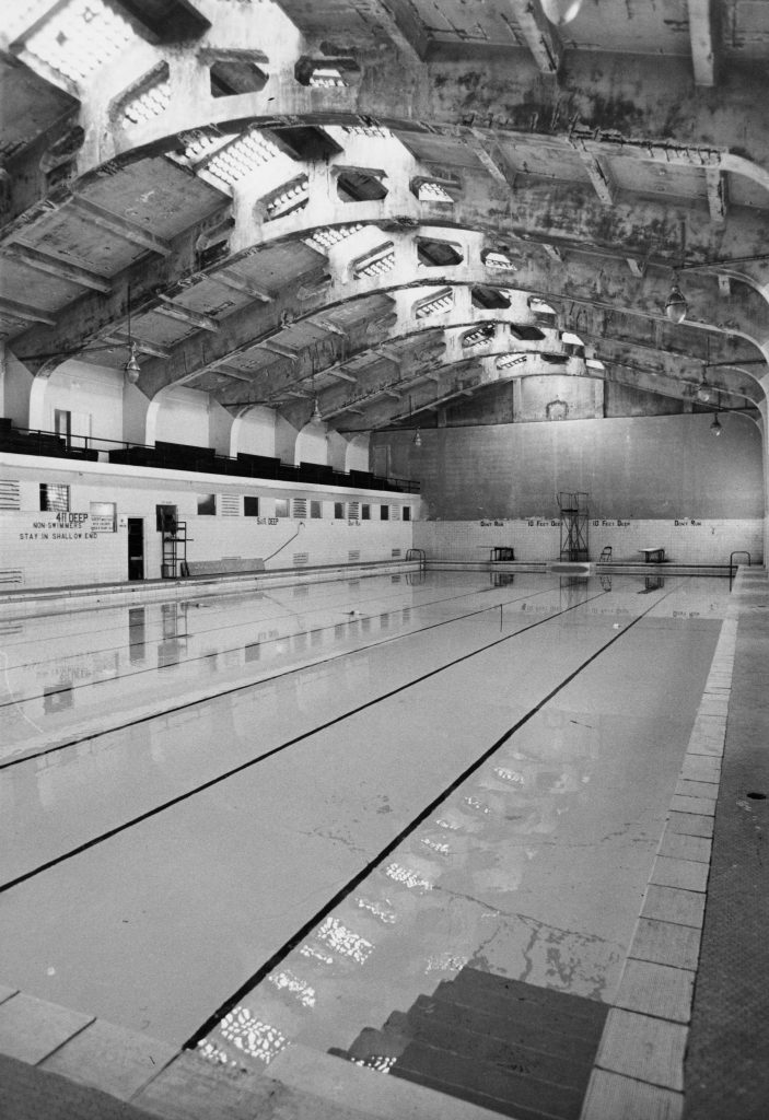
Wasatch Springs Plunge

Published / by Juli Huddleston / 7 Comments on Wasatch Springs Plunge

Write-up by Julia Huddleston

Placed By: Division of State History. The building is on the national register of historic places

GPS: 40.789, -111.900

Historical Marker Text:

Built near several warm springs, the Wasatch Springs Plunge is significant for its Mission style architecture and as an early municipal recreational facility. The warm springs along this portion of the Wasatch Fault were used by Native Americans even before the arrival of the Mormon pioneers who quickly developed the springs and constructed numerous bathing facilities, praising the warm sulphurous [sic] water for its curative and rejuvenating qualities. This substantial masonry building was built by Salt Lake City in 1921 and replaced earlier frame buildings.

Designed by the noted local architecture firm of Cannon and Fetzer, the building exemplifies the Mission Style. The stuccoed walls, red tile roofs, curvilinear parapets, arched openings and arcades are characteristic of the Mission style which emanated from California at the end of the nineteenth century and was based on the old Catholic missions.

Due to problems with the water, deterioration of the structure, construction of newer pools and changes in demographics, the facility fell into disuse in the 1970s and was closed. It was later rehabilitated and reopened in 1983 as The Children’s Museum of Utah.

Marker placed in 1993.

Extended Research:

Built in 1921, the Wasatch Springs Plunge served as a municipal pool for fifty years, tapping into the natural hot springs at the far northern end of Salt Lake City. The building, located at 840 North and 300 West was built by noted architectural firm Cannon and Fetzer and is a striking example of Spanish Colonial Revival style architecture. In its heyday, the building had two pools, administrative offices, several private soaking tanks, a barbershop, a hairdresser, and men and women’s masseurs. Additionally, there were also five rooms available for overnight guests.[1]

The Warm Springs have been utilized by all groups of people who call this region home. Historian Kathryn MacKay notes, “The 2-3 mile strip of hot springs and lake had been used for preceding centuries by the American Indians – Shoshones, Utes, Paiutes – who traveled through the area on hunting, foraging, trading, and social expeditions.”[2] It is likely that white fur trappers who were known to have visited the adjacent area also visited the springs. The first written encounter with the springs comes from a California-bound group, who followed Hastings Cutoff in 1846, and wrote of the warm water and its distinctly unpleasant odor. Erastus Snow, who, along with seven others, arrived in advance of Brigham Young’s wagon train, wrote about the Warm Springs on July 22, 1847. After describing the location, and the rocks nearby, he noted the temperature by writing, “We had no instrument to determine the degree of Temperature but suffice it to say that it was about right for scalding hogs.” Snow decided “The springs are the greatest facilities for a steam doctor I ever saw.” [3]
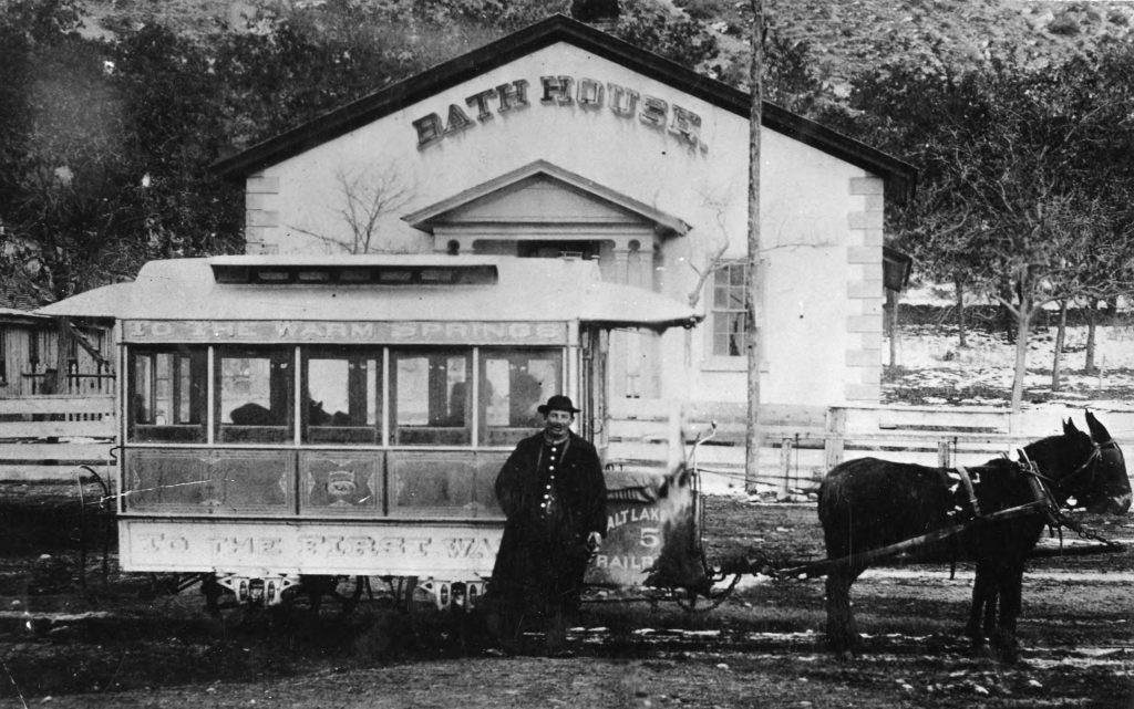
Classified Photograph Collection, “Warm Springs Bath House P. 1.” Courtesy Utah State History.

The permanent Euro-American settlement of the Salt Lake valley also marks the beginning of human-made structures intended to enhance the enjoyment of the natural springs. The springs were considered to have healing properties and were marketed not only for recreation but also for medicinal uses. In 1850, the Bath House opened and was within the purview of the neighboring Church of Jesus Christ of Latter-day Saints (LDS) 19th ward bishop’s responsibilities. By 1864, this building had fallen into disrepair and was no longer operated by the LDS Church. Over the next several decades the facilities were used for recreational purposes and, in 1916, Salt Lake City assumed ownership. It was at this point when the current structure was built and would remain in near-constant use for the next 85 years.
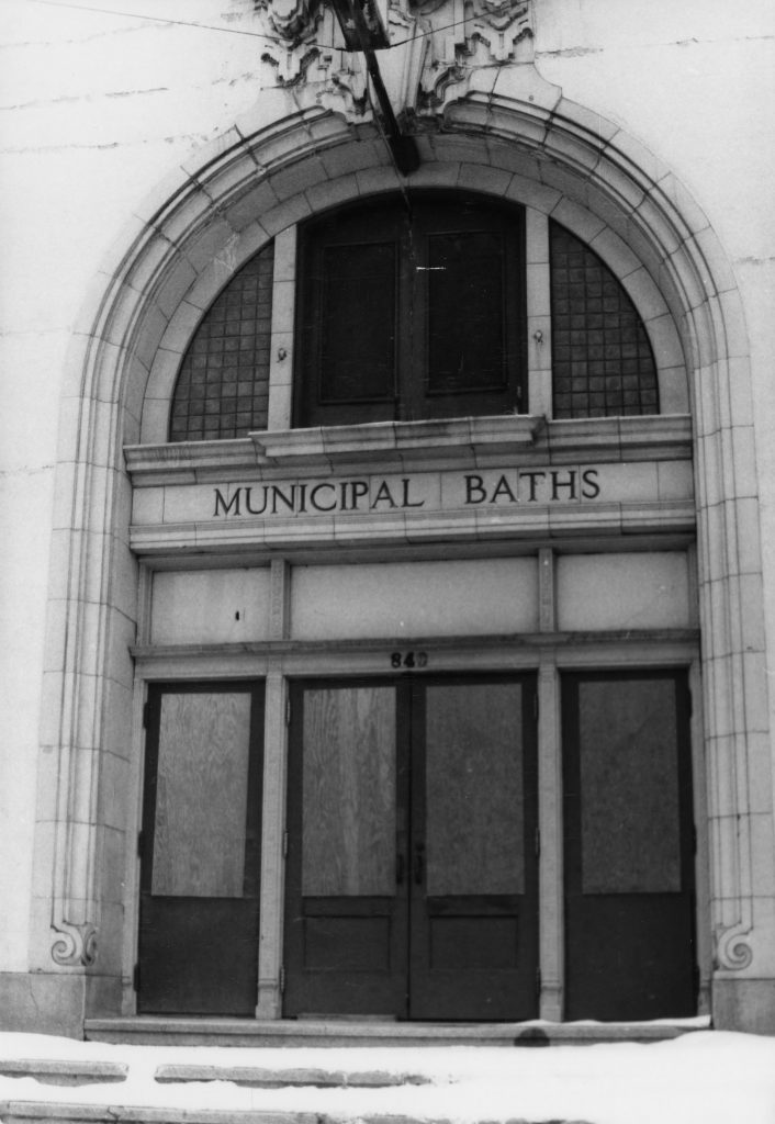
Classified Photograph Collection, “Warm Springs Bath House P. 15.” Courtesy Utah State History.
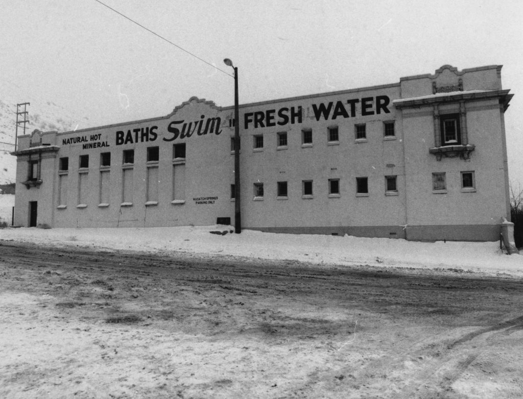
Classified Photograph Collection, “Warm Springs Bath House P. 14.” Courtesy Utah State History.
Classified Photograph Collection, “Warm Springs Bath House P. 16.” Courtesy Utah State History.

This period of the building’s history was not without problems. In 1946, concerns were raised over the sanitation of the water, and the city initially suggested chlorinating the pools. However, chlorine mixed with sulfur produces noxious chemicals, harmful to swimmers. As a compromise, the city decided to cap the natural hot springs, and the space was converted to a fresh-water, chlorinated pool.[4] Around that time, the pools began losing their appeal, and by the mid-1970s, they were no longer financially sustainable and were shuttered for nearly a decade before the Children’s Museum of Utah moved into the space in 1981.
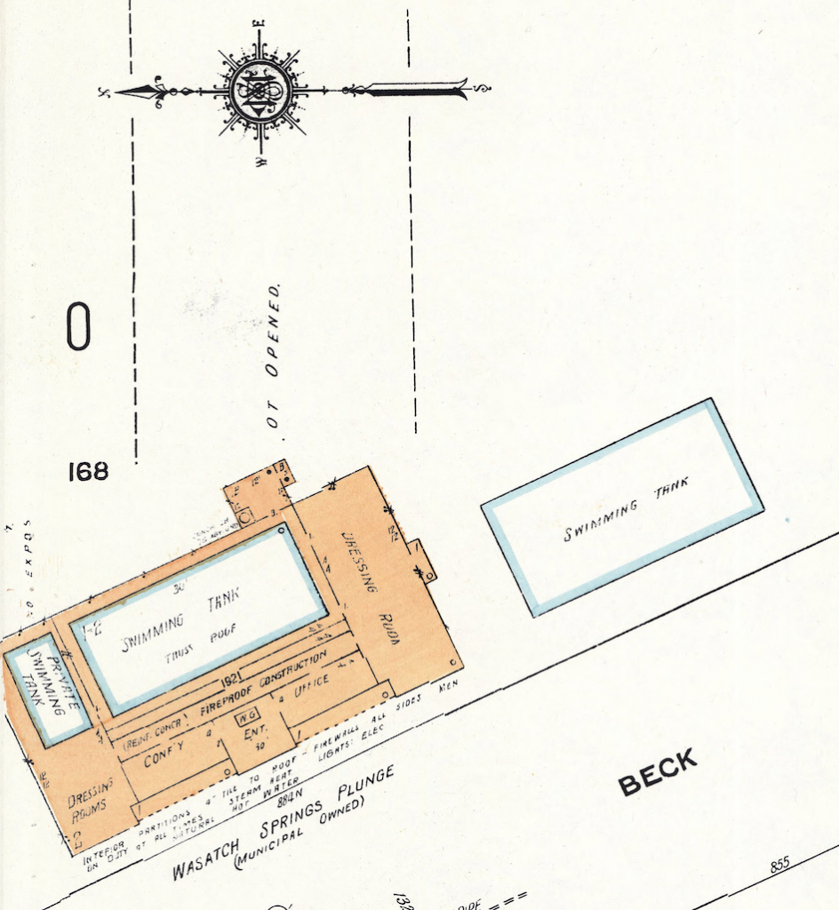
Sanborn Fire Insurance Maps, detail showing the Wasatch Springs Plunge in 1950. University of Utah Marriott Library, Print and Journal Division.

Today, the future of the building is unknown. Placed on the historic registry in 1980, the building has not been occupied full-time since the Children’s Museum of Utah moved out in 2006. The Golden Spike Train Club of Utah uses the space to house and work on their model railroad projects, but their future there is not guaranteed.[5] In 2016, Salt Lake City began accepting proposals for development, but eventually ruled out the possibility of putting housing on the site. A local organization, the Warm Springs Alliance, is advocating for the building to be used as warm springs once again.[6] However, this proposal faces significant financial hurdles. As of spring 2019, the building’s future is unknown, but there is no shortage of interest and enthusiasm for utilizing this historic gem in downtown Salt Lake.
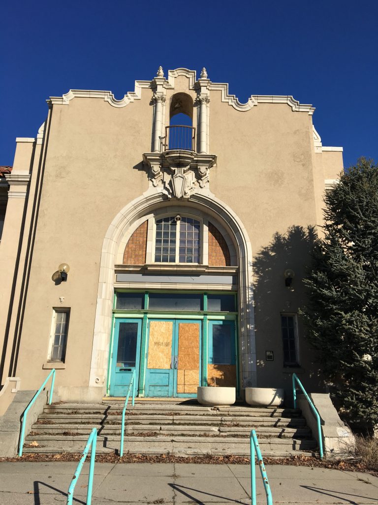
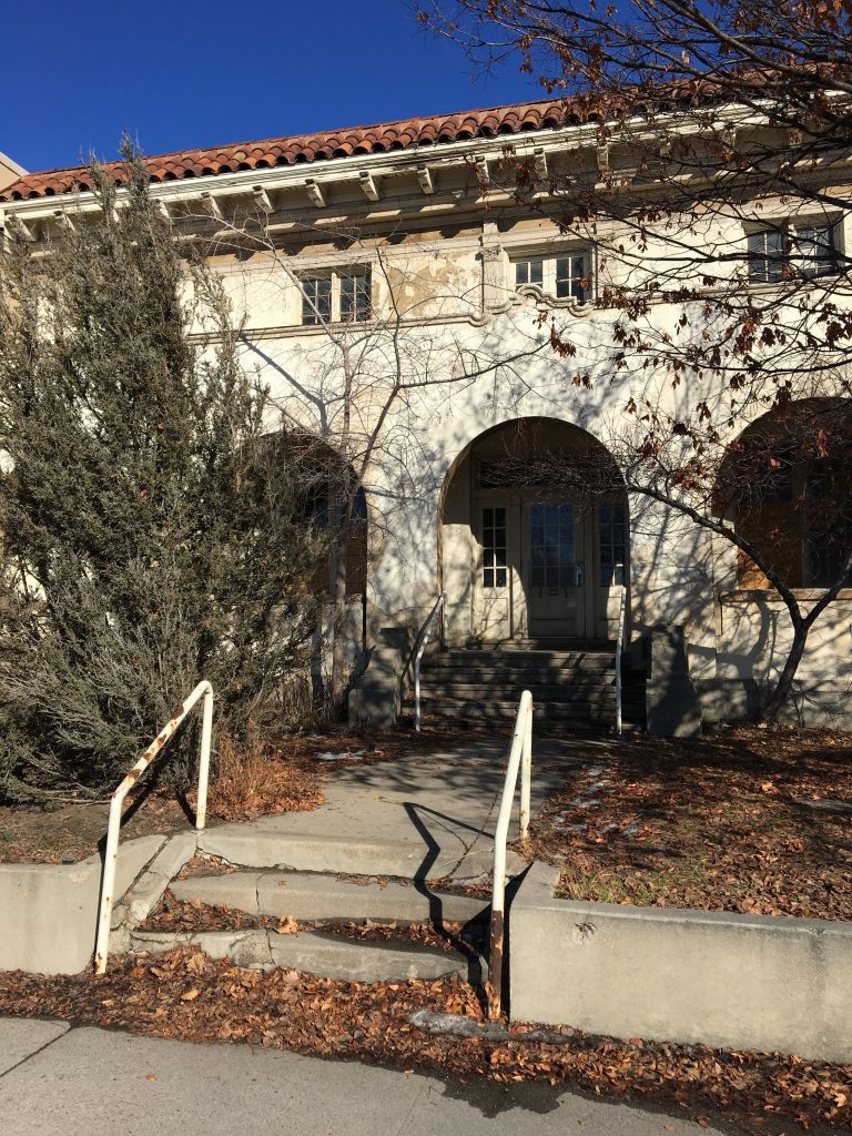
Wasatch Springs Plunge in February 2019.

For Further Reference:

Primary Sources:

Erastus Snow Journal, Church History Library, Church of Jesus Christ of Latter-day Saints, Salt Lake City.

Secondary Sources:

Lutz, Susan Juch. “Cleaned Up and Cleaned Out: Ruined Hot Springs Resorts of Utah.” GHC Bulletin (Energy and Geoscience Institute, University of Utah), 2004.

Jones, Darrell E. and W. Randall Dixon. “’It Was Very Warm and Smelt Very Bad’: Warm Springs and the First Bathhouse in Salt Lake.” Utah Historical Quarterly, Volume 76, Number 4 (2008): 212-226.

MacKay, Kathryn. “National Register of Historic Places Nomination Form: Wasatch Springs Plunge.” United States Department of the Interior Heritage Conservation and Recreation Service, 1980.

McFarland, Sheena. “Whatever happened to … Wasatch Springs Plunge?” The Salt Lake Tribune, December 23, 2014.

McLane, Michael. “The Children’s Museum.” Mapping SLC, http://www.mappingslc.org/this-was-here/item/243-the-children-s-museum.

McLane, Michael. “Past and Present Collide at Warm Springs.” Catalyst Magazine, December 1, 2017.


[1] Kathryn MacKay. “National Register of Historic Places Nomination Form: Wasatch Springs Plunge.” United States Department of the Interior Heritage Conservation and Recreation Service, 1980, 9.

[2] MacKay, “National Register of Historic Places Nomination Form,” 6.

[3] Erastus Snow Journal, July 22, 1847, as quoted in Darrell E. Jones and W. Randall Dixon. “‘It Was Very Warm and Smelt Very Bad’: Warm Springs and the First Bathhouse in Salt Lake.” Utah Historical Quarterly, Volume 76, Number 4 (2008): 212-226.

[4] MacKay, 9.

[5] Michael McLane. “The Children’s Museum.” Mapping SLC. http://www.mappingslc.org/this-was-here/item/243-the-children-s-museum. Accessed March 15, 2019. See also http://www.goldenspiketrainclubutah.org/ for information on the model train organization.

[6] http://www.warmspringsalliance.org/

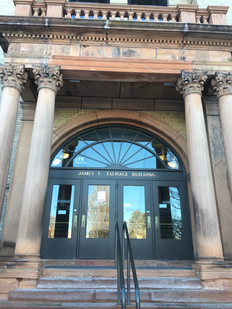
James E. Talmage Building

Published / by Courtney Edwards / Leave a Comment

Write up by Courtney Taylor

James E. Talmage Building

Placed by: The University of Utah Alumni Association

GPS Coordinates: Latitude: 40º 45’  51.702” N Longitude 111º 50’ 58.59” W

Historical Marker Text

James E. Talmage-scholar, scientist, educator, author, and church leader-was born in England and came to Utah when he was ten years old. He earned the A.B degree at Lehigh University. and the Ph.D at Illinois Wesleyan University. For his work in chemistry and geology he was elected to membership in the Royal Society of Edinbirgh. He gave vigorous leadership to the University as Professor of metallurgy and biology, as Deseret professor of geology and as the University’s second president from 1894 to 1897. His major educational concern was to build a sound system of teaching for the people of Utah who, in the 1880’s were still somewhat remote from the established centers of learning, and to incorporate into the University curriculum the expanding body of scientific knowledge.

The land on which this building stands was deeded to the University during President Talmage’s administration. Construction of the building, to be known as the Museum, was begun in 1900, but so many new buildings were going up in Salt Lake City that skilled laborers and quality brick and stone were in short supply. The building was not completed until late in 1902.

The Museum building contained classrooms, offices and laboratories for biology, geology and mineralogy; geological and biological museums; an assembly room and gymnasium. About 1920, geology classes were relocated and the Museum become known as the Biology Building until, on June, 1976 in ceremonies sponsored by the Alumni Association, it was officially named the James E. Talmage building.

Extended Research:

James E. Talmage was a respected member of the academic community as well as a leader in the Church of Jesus Christ of Latter-day Saints. Talmage was the fourth president of The University of Utah from 1894-1897 but it was not until 1976 that the building was named the James E. Talmage building.

Talmage had a life full of educational and academic success. He grew up in Provo, Utah and worked at Brigham Young Academy (now Brigham Young University). He had a love of knowledge and pursued degrees in chemistry and geology. He studied at Leigh University and Johns Hopkins University. He became one of the first Mormons to receive a PhD.1 After his time as president of the University of Utah he was called to the Quorum of the Twelve Apostles of the Church of Jesus Christ of Latter-day Saints. While he was an apostle he also published a book well known in the Church called Jesus the Christ. 

He took his job as University of Utah president very seriously and in correspondence with Elder John M. Whitaker he mentioned that it was “hard for me to do any lecturing outside the regular lectures at the institution”.2 He worked hard and he accomplished a lot in his academic life and took his job very seriously as president of the university. He was busy in his church life as well as home life as he was a father to eight children. Eventually he died from inflammation of the heart on 21 July 1933.3

The James E. Talmage building’s purpose changed over time. It was first erected as a museum building in 1902 but has primarily served as a science building. The building was built by architects Samuel C. Dallas and Williams S. Hedges who designed the building in a second renaissance revival style as the unique columns in the front of the building attest.4

The medical school took over use of the building from 1905-1920. In 1959 it was changed to the biology building to accommodate classrooms for a growing student population. Then in 1976 the building was renamed the James E. Talmage building in honor of the former university president. It is located in President’s Circle and the building is still used for science related studies.5

1 Bowman, Matthew Burton. The Mormon People: The Making of an American Faith. New York: Random House, 2012.

2 “Correspondence between John Mills Whitaker and James E. Talmage.” James E. Talmage to John Mills Whitaker. January 25, 1894.

3 Hardy, Jeffery S. “Mormon Missionary Diaries.” https://lib.byu.edu/collections/mormon-missionary-diaries/about/diarists/james-edward-talmage/

4 1992. https://preservationutah.org/images/stories/education/uofupresidentscircle.pdf.

5 “James E. Talmage Building | History of the Health Sciences.” J. Willard Marriott Digital Library. https://collections.lib.utah.edu/ark:/87278/s6p87n57

Primary Sources

1992. https://preservationutah.org/images/stories/education/uofupresidentscircle.pdf.

“Correspondence between John Mills Whitaker and James E. Talmage.” James E. Talmage to John Mills Whitaker. January 25, 1894. https://collections.lib.utah.edu/details?id=917332

Secondary Sources 

Hardy, Jeffery S. “Mormon Missionary Diaries.” https://lib.byu.edu/collections/mormon-missionary-diaries/about/diarists/james-edward-talmage/

“James E. Talmage Building | History of the Health Sciences.” J. Willard Marriott Digital Library. https://collections.lib.utah.edu/ark:/87278/s6p87n57.

“James E. Talmage (1862–1933).” James E. Talmage (1862–1933). https://www.lds.org/study/ensign/2010/03/small-and-simple-things/james-e-talmage-1862-1933?lang=eng.

“James E. Talmage Building.” Digital image. https://collections.lib.utah.edu/details?id=1036000.

Henry J. Wheeler Farm

Published / by Lindsay Adams / Leave a Comment

Write-Up by Lindsay Adams

Sariah’s Victorian farmhouse, today.[1]

Placed by: Division of State History (national register)

GPS Coordinates: 40.6353494, -111.8640506

Historical Marker Text (Currently not on Display):

Utah Historic Site: Henry J. Wheeler Farm

            The Henry J. Wheeler Farm is one of the best remaining examples of a turn of the century farmstead in the Salt Lake Valley. The farm was developed after the marriage of Henry J. Wheeler and Sariah Pixton in 1886. The modest Victorian style house was constructed in 1898 for the Wheelers by Sid Gills and Hans Yorgensen. In 1969 the farm was acquired by the Salt Lake County Recreation Department. Development of the property as a historical farm and recreational complex began in 1976. 

Extended Research:

            In 1886 Henry J. Wheeler and his wife Sariah established their farmstead in the Little Cottonwood area, on current day 900 East and 6351 South. First generation children of pioneers, Henry and Sariah’s families emigrated to Utah within the first decade of LDS settlement. Henry’s family traveled to the new territory from England in 1852, while Sariah’s family traveled to Utah under the leadership of Brigham Young in 1848. Sariah’s mother, Elizabeth, traveled alone in this company, driving the wagon herself the entire way.[2]Henry and Sariah married in 1886, setting up their farm shortly thereafter. 

            The farm originally consisted of seventy seven acres, with Little Cottonwood Creek providing irrigation for the land.[3]The semi-arid landscape of Utah required Henry to respond creatively to the needs of his land, and as such he chose to diversify the property and the holdings.  Wheeler included sheep, orchards, ice, and dairy distribution as part of his farm which made him both successful and progressive.[4]Originally the farm included a small adobe dwelling, however Sariah dreamed of more. She wanted a house in the grand victorian style, and eventually this dream became a reality. In 1898 the Wheelers built the victorian style mansion which stands on the property today. Henry Wheeler credited the design of the house to Sariah’s knowledge of architecture.[5] The finished structure boasted ten rooms, and was made of adobe and brick. The family pulled the adobe from their previous house, using it to insulate the new house. The victorian house therefore stood tall and strong, and the adobe provided good insulation for cold winter months.[6]

           During the height of the farm Henry built many out buildings which contributed to the success of his farm. These included an ice house, various barns, and a garage for his Pierce Arrow automobile. The victorian mansion also provided a cozy space to host the Wheeler’s seven children. Henry Wheeler trained his dog to fetch the mail and newspaper from the mailbox, to the amusement and delight of his grandchildren.[7] Sariah Wheeler’s expansive dining room became a gathering place for her family and extended family. Sariah’s table sat up to twenty people and during Thanksgiving she served her children and grandchildren a dinner made from turkey raised on the farm and weighing forty pounds.[8]

Picture Circa 1900. Henry Wheeler’s dogs and Farmhouse in the Background.[9]

           After the death of Henry Sr. in 1943 the farm was purchased by Richard Madsen (owner of Sterling Furniture Company). During this time it became a dairy and cattle ranch.  In 1969 Salt Lake County purchased the farm with plans to turn the property into a sports and park complex. Luckily, in 1974 the Junior League of Salt Lake asked the county if they could preserve the farm, much of which (including the buildings) had fallen into disrepair. After extensive research and renovation the farm was included on the National Historic Registry, and opened to the public officially in 1976 as Wheeler Historic Farm.[10]

            Since it’s opening as a preserved site, the farm has provided visitors with a glimpse of what farm life was like in the Salt Lake Valley between 1880 and 1910. The farm boasts a collection of almost 6,000 farming artifacts important to the history of Utah farming. It also houses animals such as sheep, goats, horses, cows, turkeys and chickens. The farm has engaged in community outreach and learning, including renting out garden plots, grassroots music festivals, Sunday farmers markets and Halloween corn mazes.[11]Meticulously preserved, visitors can tour Sariah’s grand Victorian farmhouse for a nominal fee Monday through Friday. Visitors can lead themselves on a self-guided tour through the rest of the farm any day of the week. The farm continues to provide glimpses into Utah’s past, as well as a place of learning and gathering for Utah families. 

For Further Reference

Primary Sources

Biographical Record of Salt Lake City and Vicinity: Containing Biographies of Well Known Citizens of the Past and Present. (National Historical Record,1902), 429. 

Mastrim, Beverly Wheeler. A number of oral interviews with Ms. Mastrim are available on the Salt Lake County Website

Secondary Sources

“Family Gardening,” Salt Lake Community College Newspaper(Salt Lake City, UT), October 4, 1989.

Lamborn, John E. and Peterson, Charles S. “The Subsistence of the Land: Agriculture v. Industry in the Smelter Cases of 1904 and 1906” Utah Historical Quarterly53 (1985): 310.

Marriott Library Digital Collection, Original managed by Murray City Museum. 

Salt Lake County, “Story of Wheeler Historic Farm.”


[1]Photo taken and owned by author.

[2]Biographical Record of Salt Lake City and Vicinity: Containing Biographies of Well Known Citizens of the Past and Present, (National Historical Record, 1902), 429. 

[3]Biographical Record of Salt Lake City, 429.  

[4]John E. Lamborn and Charles  S. Peterson. “The Subsistence of the Land: Agriculture v. Industry in the Smelter Cases of 1904 and 1906” Utah Historical Quarterly53 (1985): 310.

[5]Biographical Record of Salt Lake City and Vicinity: Containing Biographies of Well Known Citizens of the past and Present. (National Historical Record,1902), 429. 

[6]Salt Lake County, “Story of Wheeler Historic Farm” 

[7]Beverly Wheeler Mastrim, “Grandpa Wheeler and His Dog,” Oral Interview.

[8]Beverly Wheeler Mastrim, “The Dining Room and Thanksgiving,” Oral Interview.

[9]Marriott Library Digital Collection, Original managed by Murray City Museum. 

[10]Salt Lake County, “Story of Wheeler Historic Farm.”

[11]“Family Gardening,” Salt Lake Community College Newspaper(Salt Lake City, UT), October 4, 1989 and  Salt Lake County, “Story of Wheeler Historic Farm.”

McCune Mansion

Published / by Thomas Lee / Leave a Comment

write-up by Thomas Lee

Placed by: The Division of State History

GPS Coordinates: Latitude 40.773 Longitude -111.890   40°46′26″N 111°53′26″W

Historical Marker Text:

The mansion, completed in 1901 was designed for Alfred W. and Elizabeth McCune by architect S.C Dallas. Alfred McCune acquired great wealth through railroad, mining, and timber enterprises. In 1920, after the McCune’s moved to Los Angeles, they gave the building to the Church of Jesus Christ of Latter-day Saints. It then housed the McCune School of Music until 1958 when it was used as an extension school for Brigham Young University. The mansion was purchased by McCune Associates in 1973.


Extended Research:

Alfred W. McCune

The McCune Mansion is named after its original owner Alfred W. McCune. Alfred McCune was born at a British military base in Calcutta India. Missionaries from the Church of Jesus Christ of Latter-day Saints who were proselyting in India preached to the family and taught the children including Alfred. Alfred’s father decided to move the entire family to Utah while Alfred was still a child. Alfred thus spent most of his life and upbringing in Utah.

The McCune family home which Alfred grew up in was in Nephi, Utah. Alfred’s family was of moderate wealth and he had to work to help support himself. He started out as a shepherd in Nephi. At the age of nineteen, Alfred got a job on the Union Pacific railroad that was then being built in eastern Utah.

Being exposed to the industrialism and capitalism of the railroad, Alfred was inspired to venture into business himself. Alfred started with a general store and then secured timber contracts for the still expanding railroads in Utah. Alfred saw many business partners come and go through the years but he always held true and persevered in business to gain extraordinary wealth. As a result, Alfred became one of the first millionaires in the state of Utah. He used some of his fortunes to improve infrastructure in the state. He owned one third of the early trolley cars that ran through Salt Lake City and was a major factor in the trolleys’ conversion to electricity.

Alfred McCune also became involved in state politics. He made an unsuccessful run as senator in 1898 and later as governor in 1916. It was after this second loss that McCune decided to move to Los Angeles in 1920. McCune continued to invest in railroads and was one of the largest investors of rail and timber in Peru. In 1924 McCune’s wife, Elizabeth, became sick and died ill in bed at the Hotel Utah. She was buried in Nephi. McCune died while on vacation in France in 1927 and was buried next to his wife in Nephi, Utah.

The McCune Mansion took just over two years to construct at the cost of just over one million dollars. It was completed in 1901. McCune’s wealth was so great by that point that he spared no expense and is said to have let his wife have anything she wanted for the house. The Architect chosen by the McCunes was S.C. Dallas who was a prominent Utah architect at the time having designed the Brigham Young Monument (1897) and the Brooks Arcade (1890). The Family sent Dallas on a tour of America and Europe in order to get design insights. Much of the outside of the building is made out of Utah sandstone. The tiles were imported from the Netherlands and a mirror was shipped from Germany and required a special boxcar to safely carry it to Utah.

Mirror pictured in first-floor dining area. “This mirror was believed to be the largest mirror west of the Mississippi in the United States when it arrived by specially designed box car delivery in 1900” -Shawn Fletcher (property manager of the McCune mansion 2019).

The McCunes only owned the home for twenty years when in 1920 they donated it to the Church of Jesus Christ of Latter-day Saints. In 1921 the building became the McCune school for music and arts and it also housed the Virginia Tanner school of modern dance. Then in 1958 the building was used primarily as an extension school for Brigham Young University. The Building was sold to McCune associates in 1973. In 1974 the building was listed on the national registry of historic buildings. It was used to limited success as a social hall. In 1999, after a tornado in Salt Lake City damaged the building, the McCarthy family purchased the home and began restoration. The home was repaired the following year and has undergone extensive interior restoration. The building is currently being used as a private reception hall and restoration continues through 2019.

The restoration is never over according to Shawn Fletcher, the property manager of the McCune Mansion. In 2011, proof of that was evident when Fletcher reclaimed an original piece of stained glass from an antique auction in Los Angeles. This recovery effort was recorded in the Salt Lake Tribune. The stained glass window was original to the home and Fletcher bought it at the cost of $14,000 and then personally drove it back from Los Angeles to Salt Lake City.

The recovered stained glass window.

The opulent mansion that sits atop the hill at 200 North and Main Street in downtown Salt Lake City has served as a home, an art space, a dance studio, a classroom and a reception hall since 1901. Ongoing preservation efforts will ensure that the McCune Mansion will survive for another century and beyond.

For Further Reference:

Primary

Dallas and Hedges Blueprints, 1900-1901. 1900.University of Utah. Libraries. Manuscripts Division.

Secondary

Carter, Thomas, and Goss, Peter L. Utah’s Historic Architecture, 1847-1940 : A Guide. University of Utah Press 1988. Print.

Drake, Katie “Salt Lake City’s McCune mansion recovers lost window” Salt Lake Tribune, September 13, 2011.

Fletcher Shawn. Interview by Thomas Lee. At the McCune Mansion, February 1, 2019.

Goodman, Jack. As You Pass by : Architectural Musings on Salt Lake City: A Collection of Columns and Sketches From the Salt Lake Tribune. Salt Lake City: University of Utah Press, 1995. .

Whitney, Orson F. History of Utah : Comprising Preliminary Chapters on the Previous History of Her Founders, Accounts of Early Spanish and American Explorations in the Rocky Mountain Region, the Advent of the Mormon Pioneers, the Establishment and Dissolution of the Provisional Government of the State of Deseret, and the Subsequent Creation and Development of the Territory. 1892.

“Utah’s Architectural Heritage: Alfred W. McCune Mansion.” Utah Architect 60 (Autumn 1975).

Yusaf, Shundana. “McCune Mansion.” SAH Archipedia. Accessed April 09, 2019.

.


Hogan Pioneer Cabin

Published / by Mandi Payne / Leave a Comment

By Mandi Payne

Dedicated by: Daughters of Utah Pioneers 1976

GPS location: 40*52’29” N 111*54’2” W                                    

Plaque A

In 1848 Eric G. M. Hogan, a Norwegian immigrant and the first South Bountiful settler, built a cabin for his wife Halga and their children on the site located approximately 934 West and 1500 South. A second cabin, constructed in 1857 for his wife Ingeborg was located a block east of the first home. In 1862 Mr. Hogan married Hannah Nielson an expert carpet weaver. While she wove, Ingeborg cared for Hannah’s five children. This family of eight lived in the house for seventeen years. In 1934 Hyrum Hogan, eldest son of Eric and Hannah and his wife Margaret, presented this cabin to the Eutaw Camp of the D. U. P. who moved it to the grounds of the South Bountiful Church. Fire destroyed the Church in 1975 and the Cabin was moved to the City Park. Here it stands as a memorial to the Hogan Family and all the pioneers who came to this area.

Plaque B

In 1848 Eric G. M. Hogan and Family settled in South Bountiful. In 1858, he built this cabin of native logs for wife Ingeborg. The slab roof was fastened with wooden pegs a ladder in corner served an upper room. Hannah joined the family in 1882, whose five children were born here. After seventeen years a larger home was built and the Cabin became a granary. Given to D.U.P. by Hyrum and Margaret Hogan for a relic hall. Moved to this location in 1978.

The Story of the Cabin

In Woods Cross, Utah, at 1500 South just East of Main Street is a park. This park is not like all of the other parks in Utah. Like any other park it has two playgrounds for children to play on, swing sets for high flying adventures, courts for pickle ball and basketball and a baseball diamond in the back.  Unlike most parks, however, there is a little log cabin that sits near the street on the North side of the park. This log cabin was built by Eric Gautesson Midtboen Hogan in 1857.

Erick G. M. Hogan

Erik Gautesen Midtboen Haugen, was born in Norway on June 23, 1802. After the death of his first wife, Kari Sondresen who died in childbirth, he married Helge Knudsen in 1829. Together they had five children and lived a good life, until Haugen heard people talking about America and the life that they could have there. Haugen felt the draw of a better living than he had in Norway. They weren’t poor but they weren’t wealthy. Hogan felt that the move would improve their status and wanted to move straight away.  Helge took a few years to be swayed on moving,  Hogan told her,  “well, I am going; we will separate; I will take two of the children; you may take two and we will cast lots for the fifth one.”[1] This comment swayed Helge to agree and together with their five children the family left for America in 1837 where he changed the spelling of his name to Eric G. M. Hogan.

The Hogan family had many hardships on their journey to a new world. Their third child, four-year-old daughter Heige died at sea. When they arrived in America the pouch that held their money went overboard, and though they recovered some money they still lost $200. At first, they stayed in Chicago where they lost another child, three-year-old Margit. They then moved to Ottawa, Illinois where other Norwegian families lived. There, a sixth child was born who they named Harriet. It was also in Ottawa in 1843 that the family converted to the Church of Jesus Christ of Latter day Saints and moved to Nauvoo to be with the saints there. They had three more children named Elizabeth, Margaret, and Regena. On April 17, 1846 they moved West with the rest of the members of the Church of Jesus Christ of Latter-Day Saints. They arrived in the Salt Lake Valley in September 1848 after one more child, their tenth was born and Helge, became seriously ill.

Ingeborg Maria Jensen Hogan

Erick Hogan found some land north of Salt Lake City and settled his family near a nice stream. Later this area would be known as South Bountiful and Woods Cross.  In 1858 he became a polygamist when he married Ingeborg Maria Jensen. In 1862 he married a third living wife, Hannah Nilsson. Ingeborg had no children and Hannah had five. Together the second and third wives lived in the cabin that Erick built in 1857 for Ingeborg. In 1878 during the diphtheria epidemic, three of Hannah’s children died.

Hannah Nilsson Hogan

The cabin as Hogan built it in 1857 was described as, ‘a house with one room downstairs and one up, with a slab roof and an adobe chimney.’ [2] It was built at a different location, on about 934 West and 1500 South. A second room was built off the main room for Hannah to do her weaving.[3] After it was no longer used as living quarters, the Hogan Family used it to hold hay or injured animals. In February 1934 in a Daughter’s of the Utah Pioneers meeting in Bountiful Utah, Hannah and Erick Hogan’s first born son Hyrum announced that he and his wife “would present the camp with their log cabin.”[4]

Hogan Cabin being moved

 When the DUP received the cabin, they loaded it onto a tractor and took it to the East side of the Church grounds. [5] They relocated the cabin to the Latter-day Saint chapel about 15,000 feet away from where the meetings of the DUP’s Eutaw Camp were being held. It was chosen to ‘be preserved as a relic hall and as a memorial to the sturdy faithful pioneers of the community.’[6] The DUP also said that ‘it will be used as a meeting place for the members of the DUP camp and also to house pioneer relics.’  [7] There are now several artifacts that are housed in the cabin which were donated by members of the community and the DUP, however only three of those artifacts once belonged to the Hogan family.

The Hogan Cabin being moved.

The DUP used the building to hold meetings and socials. In March of 1975 a fire engulfed the Latter-day Saint Chapel but luckily left the cabin untouched. After the fire was extinguished, the cabin looked like “a tiny ghost house against the blackened ruins of the church.”[8] A group of people, including members of the DUP and community,  decided then that the cabin needed a better home and so, the cabin was moved again by the DUP, this time across the street where the park is. They carefully moved the cabin and then renovation and restorations began. They filled in the missing and broken panels of wood with new ones, and someone was hired to build a new fireplace for the cabin, making it no longer the simple adobe style that was first there.[9]

The Hogan Cabin being put on a concrete slab at Hogan Park in Woods Cross.

On August 9, 1976 people in the community and members of the DUP gathered at Hogan Park to dedicate the cabin as a relic of the past. Members of the community and the DUP gathered in attendance. The DUP organized a program with musical numbers and speakers who talked about the history of the cabin and its inhabits along with its restoration and the journey the cabin had go take to get to this spot. A plaque by the cabin was unvalued for the bicentennial celebration of Eric Hogan arriving in the South Bountiful area. There were about 250 people present on the cool summer evening. All in attendances were invited to linger and view the cabin while the DUP served refreshments.

Now visitors who which to see the interior of the cabin can do so by appointment only by calling the Woods Cross City Hall. Visitors will note that the floor of the second room has been removed, exposing the ceiling. There are horizontal beams placed where the ceiling would be to help with the integrity of the cabin. The DUP member in charge invites visitors inside the small cabin and then they are free to look around for a while at all of the artifacts. She talks about the Hogan family and some of the things that they endured to reach South Bountiful. Then she takes them on a short history of the development of Woods Cross. The DUP envisioned this cabin to “stand as a memorial to all our pioneer forefathers and may we appreciate our heritage and live so that they will be proud of us.” [10]

Notes:

[1] Eric’s Life Story” by Oria Haven Barlow

[2] “Eutaw Camp, DUP to Dedicate its Relic Cabin Sunday,” Davis County Clipper 1938

[3] Interview with Lenore Peterson of the DUP

[4] “Woods Cross,” Davis County Clipper, February 1934

[5] The Restoration of the Eric G.M. Hogan Log Cabin, by The Daughters of the Utah Pioneers 1976

[6] “Eutaw Camp, D.U.P. to Dedicate its Relic Cabin Sunday”, Davis County Clipper 1938.

[7] “Woods Cross,” Davis County Clipper, September 1934

[8]  ”The Restoration of the Eric G.M. Hogan Log Cabin”, by The Daughters of the Utah Pioneers 1976

[9] Interview of Lenore Peterson of the DUP

[10] DUP “Dedication of the Eric G. M. Hogan Pioneer Cabin”

Primary Sources

Secondary Sources

  • Barlow, Ora Haven “Eric’s Life Story” found on Family Search Contributed by P. Cory Hogan on June 2013

Other References


Dixie Academy

Published / by Isaac Gines / 3 Comments on Dixie Academy

Write-up by Isaac Gines

Placed by: St. George Historic Preservation Commission

Coordinates: 37.1068 N, -113.5836 W

Location: 86 South Main Street, St. George, UT 84770

Historical Marker Text:
“Dixie Academy was constructed to provide advanced courses of study.  The St. George Stake Academy officially began in 1888 and moved into this building in 1911.  A four-year program was recognized as two years of senior high and two years of college. The college program grew into the institution known as Dixie Jr. College and eventually Dixie College.”

Extended Research:

Built in 1911, the Dixie Academy building housed both Dixie College, the predecessor to Dixie State University, and Dixie High School.  The St. George Stake Academy, which opened in 1888, preceded Dixie Academy.[1]  The St. George Stake Academy functioned similarly to the Salt Lake Stake Academy, which ended its second academic year on June 8, 1888. They were both educational facilities built by the Church of Jesus Christ of Latter-day Saints in an effort to provide secular and religious education to its members.[2]

Construction of the current building began in 1910 and concluded in 1911, using sandstone and basalt blocks.  George Brooks, a notable St. George mason, led the project.[3]  Basalt, being notoriously difficult to fashion, is not featured in the 2005 addition. To form adequate bricks, the basalt was hammered into rough rectangles, an extensively laborious process, which is why they were omitted from the 2005 addition. For the original building the southern Utah landscape provided materials and inspiration for prominent features during its construction. Totaling $55,000 to construct, the Church of Jesus Christ of Latter-day Saints earmarked $35,000 toward the project, but only if the remaining $20,000 could be raised by the local population.[4]  The funding from the LDS Church is significant, because in 1910 there were active campaigns to renovate the high school in Salt Lake City, but the funding depended upon the proposed issuance of bonds.[5] In contrast, at St. George the funding from the church enabled the population of Washington County to avoid the incurrence of debt to provide a quality facility. Along with the nearby St. George Tabernacle and St. George Temple, the Academy made St. George a gathering place and central hub for the Washington County Community.[6]

The Dixie Academy building initially housed high school juniors and seniors, as well as college freshmen and sophomores and employed 25 faculty members.  Dixie Academy was among the academies built by the LDS Church as it expanded its educational offerings in the late 19thcentury and into the early 20thcentury.  Beginning in 1925, however, the LDS Church began the process of closing many of these academies due the proliferation of secular public high schools.  In 1933, Dixie Academy was closed, which triggered a crisis in the community.  The LDS Church, financially stretched as a result of the Great Depression, made difficult decisions to best allocate the funds it had. This included the closure of several similar schools throughout Utah, although several were transferred to the state. After negotiations with the state legislature, the LDS Church authorized the transfer of Dixie Academy to the state, however the residents of Washington County were left to fund the school on their own.  Donations of money and labor funded this endeavor, keeping the academy alive through 1935. 

In that year, the State Board of Education began funding Dixie Academy, which had grown to a student body of about 400. The State Board attempted to split the high school and college, with the intention of giving responsibility for the high school to Washington County and continuing their own administration of the college. This was met with significant local resistance, for Washington County did not have the funds to construct a new high school and they also felt that the various social and academic activities the Academy had become known for necessitated a larger student body.[7]

Between 1935 and 1963, calls by the state to close the Academy increased. The locals in Washington County, recognizing the value in education and the ability of the Academy to deliver quality learning for the community, fought cleverly to preserve their institution through donations to the institution and lobbying in the State Legislature. Eventually, the Dixie Education Association raised enough money to purchase four blocks for the construction of a new campus for the Academy. They presented this land to the state, initiating the construction of the new college. The gymnasium’s completion in 1957, along with other buildings prior to 1963, triggered the departure of the college students from Dixie Academy, leaving the high school students in their original building.

Eventually, in 1966, Dixie High School relocated to a new campus.[8]  The Washington County School District stayed in the nearby Woodward Building, using it for its administrative offices, but the Dixie Academy building became vacant. Later, the city of St. George acquired Dixie Academy, which now leases the building to the St. George Children’s Museum, leaving many of the offices and classrooms intact.  The gymnasium on the top floor is now used as an event space.


[1]n.d. Dixie Academy Building. Accessed March 18, 2019.

[2]Done, Willard. 1888. “Stake Academy.” Utah Digital Newspapers. June 5. Accessed April 8, 2019.

[3]Dixie Academy Building in St. George, Utah. n.d. Accessed March 18, 2019.

[4]n.d. Dixie Academy Building. Accessed March 18, 2019.

[5]Civic Committee, Federation of Women’s Clubs. 1910. “Inadequacy of the Present High School.” Utah Digital Newspapers. January 23. Accessed April 8, 2019.

[6]Church, Lisa Michelle, and Lynne Clark. 2019. “St. George: Early Years of Tourism.” Utah Historical Quarterly, February 11: 48-49. Accessed April 8, 2019. 

[7]Alder, Douglas. n.d. What is Dixie State University? Accessed March 18, 2019.

[8]n.d. Dixie High School. Accessed March 18, 2019.


For Further Reference:

Primary Sources:

Civic Committee, Federation of Women’s Clubs. 1910. “Inadequacy of the Present High School.” Utah Digital Newspapers.January 23. Accessed April 8, 2019.

Done, Willard. 1888. “Stake Academy.” Utah Digital Newspapers.June 5. Accessed April 8, 2019.

Secondary sources:


Alder, Douglas. n.d. What is Dixie State University?Accessed March 18, 2019.

Church, Lisa Michelle, and Lynne Clark. 2019. “St. George: Early Years of Tourism.” Utah Historical Quarterly, February 11: 48-49. Accessed April 8, 2019.

n.d. Dixie Academy Building.Accessed March 18, 2019.

Dixie Academy Building in St. George, Utah. n.d. Accessed March 18, 2019.

n.d. Dixie High School.Accessed March 18, 2019.


Old Rock School House

Published / by Brianna Siddoway / Leave a Comment

Placed by: Daughters of the Utah Pioneers, No. 13

GPS coordinates: 40.9142194 degrees north, -111.3975917 degrees west

Photo taken January 29th, 2019 by Brianna Siddoway

Historical Marker Text:

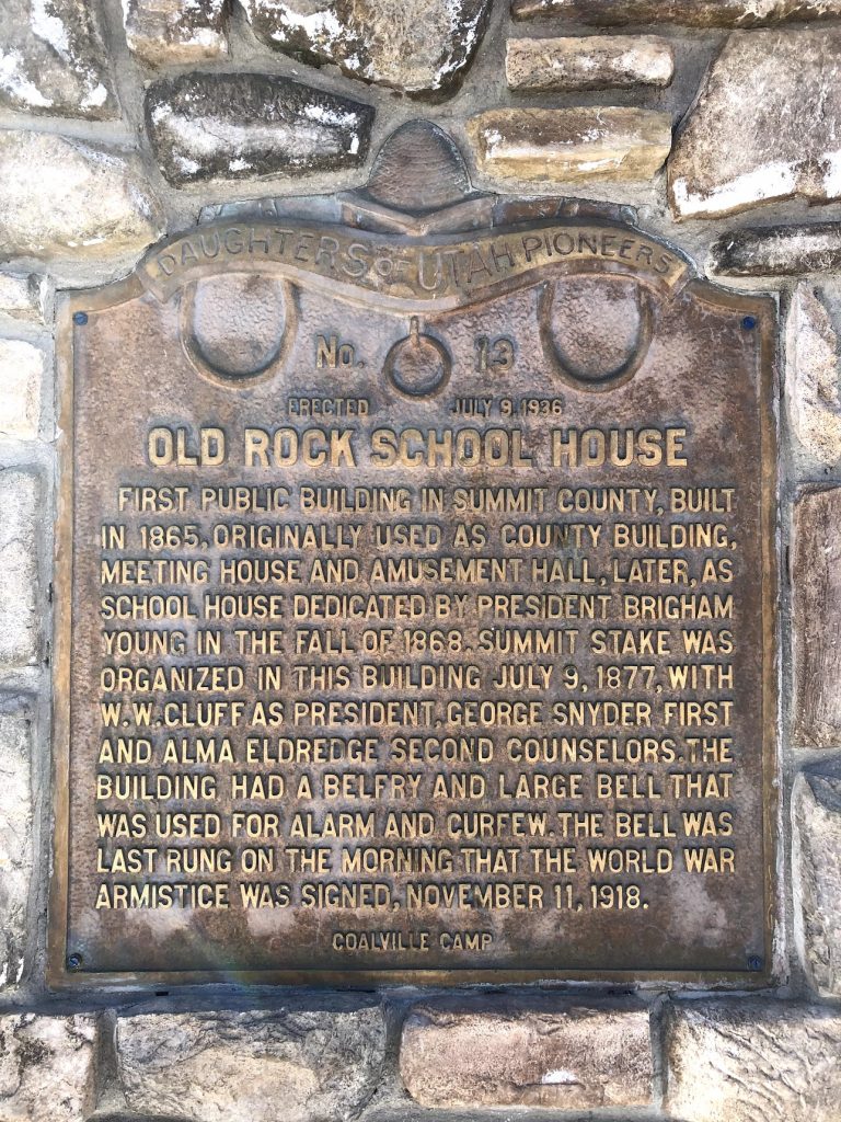
First public building in Summit County, built in 1865, originally used as county building, meeting house and amusement hall, later, as school house dedicated by President Brigham Young in the fall of 1868. Summit Stake was organized in this building July 9 1877, with W.W. Cluff as President, George Snyder first and Alma Eldredge second counselors. The building had a belfry and large bell that was used for alarm and curfew. The bell was last rung on the morning that the World War Armistice was signed, November 11, 1918.”

Photo taken January 29th, 2019 by Brianna Siddoway

Extended Research:

In its early years as a settlement, the people of Coalville used a small log cabin for a school and meeting house for religious services. From 1864 to 1865 the community banded together to build a new, larger building to accommodate their growing numbers. Settlers donated whatever labor, time, and supplies they could spare to the effort.[1] Fredrick Wilde owned land in Coalville and wanted a church to be built there. He and many others helped to build what became a regional church building for members of the Church of Jesus Christ of Latter-day Saints who lived in the Summit County area, also called the Summit Stake House.[2]

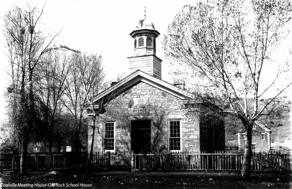
Near the chosen location for the new building was a ledge of stone which the builders decided to use in constructing their new meeting house. Thus, the finished structure came to be known as the “Rock Church,” “Rock Chapel,” and “Rock School House.” Lumber, however, was not as readily available and had to be brought from Sawmill Canyon, approximately 10 miles away, up Echo Canyon. One settler, William H. Smith, donated ox teams to the effort of hauling stone to the site and to collecting logs from canyons while other settlers donated labor at the saw mill.[3]

Photographer George Beard 1855 – 1944
Photo provided by NaVee Vernon, Summit County Historian, January 2019

When the building was completed in 1865, the community began to use it as a church and school house. A small, one room structure, the Rock School House was built with a belfry, which housed the bell used to call school children to their lessons. The bell was also used as a warning sign to the community, in which cases the building was used as a refuge. The Rock Church was further used as a social and amusement hall for parties and dances. It sometimes became a government center for the county as well, where “laws and rules were formulated [to] govern the people.”[4]

In September 1869, a few years after its completion, Brigham Young, President of the Church of Jesus Christ of Latter-day Saints, dedicated the building. On September 24th the Deseret Evening News reported that at the time it was being built, many thought it would be too large, but after it was finished, due to population increase, the community had already outgrown its Rock Church. “It is a chaste, elegant building,” the News reported, “beautifully finished, and it is a credit to the place.” During his trip to dedicate the building, President Young counselled the Bishop of Summit and Morgan counties, W.W. Cluff, “to take steps to build a larger meeting house… and when done to use the present building for a schoolhouse.”[5]

Rock Chapel as it stands in Lagoon’s Pioneer Village. Taken June 13th, 2011; found here.

The bell was last rung on November 11, 1918, otherwise known as Armistice Day, when the bell signaled the end of World War I. The small building continued to be used as a social hall and later as a seminary for the Church of Jesus Christ of Latter-day Saints until 1975 when it was sold to Lagoon’s Pioneer Village where it stands today with its original furniture on display.[6]

Rock Chapel Sign, on site in Lagoon’s Pioneer Village. Taken June 13th, 2011; found here.


Rock Chapel Sign Text:

The Pioneer Village Little Rock Chapel has as fascinating a history as any building in Utah. Originally located on Main Street in Coalville, it was constructed in 1863 as a fort against the Indians, and was used in more than one attack. When the Indians became friendlier, the building became a courthouse with the jail attached to it. Later as the area grew, it was turned into a schoolhouse and became the center for social activities in the Coalville area. Finally, in 1869, the chapel was dedicated by Brigham Young as an LDS church. It retained its importance as a meeting place for both social and political activities in the community. Constructed of hand-drilled, hand-cut blocks of Summit County sandstone, the chapel contains the original pews, pot-bellied stove and lectern. Paneling and pews were wood-grained to simulate hardwoods. This was commonly done through this period, when only softwood was available and the appearance of hardwood was more desirable. This church is a unique and lovely reminder of Utah pioneer heritage.


[1] Rhea M. Bagnell, “The Old Rock School House in Coalville”, Personal History. Provided by Summit County historian NaVee Vernon.

[2] Louisa Wilde Ballantyne, “Our Book of Remembrance,” A History of Fredrick George Wilde by Louisa Wilde Ballantyne. January 01, 1970. Accessed February 05, 2019.

[3] Bagnell, “The Old Rock School House in Coalville”, Personal History.

[4] Bagnell, “The Old Rock School House in Coalville”, Personal History.

[5] “Editorial Correspondence,” Deseret Evening News, (Salt Lake City, Utah), 24 September 1869, 2. Utah Digital Newspapers, accessed March 16, 2019.

[6] Walter Lee, “The Old Rock School House,” Issue brief, compiled by Mary Andersen, Daughters of the Utah Pioneers. Provided by Summit County historian NaVee Vernon.


For Further Reference:

Primary Sources:

Secondary Sources:

  • Lee, Walter. The Old Rock School House. Issue brief. Compiled by Mary Andersen. Daughters of the Utah Pioneers. Provided by Summit County historian NaVee Vernon.
  • Coalville School Bell and the Old Rock School House. Daughters of The Utah Pioneers. Provided by Summit County historian NaVee Vernon.

Other sites you may be interested in visiting:


Assembly Hall at Temple Square

Published / by A.J. DeMond / Leave a Comment

Write up by A.J. DeMond

G.P.S Coordinates: N 40° 46.189 W 111° 53.582

Historical Marker Text: “The Assembly Hall, constructed of granite stone left over from the building of the temple, was completed in 1880. It is a place of public worship, in which visitors are welcome. Although the building is used mainly for conferences of the Latter-day Saints congregations located in Salt Lake City and for other Church meetings, it is also available for various cultural and civic functions. The Gothic Revival structures is 68 feet wide and 120 feet long and the center tower is 130 feet high. The auditorium holds almost 2,000 people, with choir seats for 100. The truncated spires were originally chimneys.”

Extended Research:

 “[A]t a priesthood meeting of the Salt Lake Stake, held August 11, 1877, President B. Young proposed to pull down the Old Tabernacle, and build a new one to accommodate about 3,000 people.[1]” Young would pass away eighteen days after this meeting and would not live to see the beginning of construction on the beautiful building which resulted from his proposal. Leaders of the Salt Lake Stake of the Church of Jesus Christ of Latter-day Saints would take Young’s direction and oversee the process of construction on the Salt Lake Assembly Hall.

          The Assembly Hall was designed by architect Obed Taylor who oversaw the building project after being commissioned. The building was constructed on the southwest corner of Temple Square directly south of the Tabernacle. The architecture is heavily modeled after Victorian Gothic influences. “Rough Granite walls are placed in cruciform style” which resembles many gothic cathedrals in Europe. [2] The roof is marked by twenty-four spires that give unique distinction to the edifice relative to the other buildings on Temple Square. Another unique feature is the inclusion of Stars of David high above each entrance.

Using mostly discarded granite stone from the construction of the Salt Lake Temple, builder Henry Grow completed construction in 1882 at a total cost of $90,000. During the first two years of construction the building was often referred to as the new tabernacle but was officially named “The Salt Lake Assembly Hall” in 1879 by then LDS church president John Taylor in order to distinguish between it and the already existing domed Tabernacle to the north. The first regional meetings of the LDS Church known as stake conferences were held in the Assembly Hall in January of 1880 while the building was still under construction.[3]  

Figure 1: Salt Lake Assembly Hall under construction, circa 1880[4]

          The Assembly Hall was officially dedicated in 1882 under the direction of President Joseph F. Smith, a member of the First Presidency of the Church of Jesus Christ of Latter-day Saints. Upon its completion, the Assembly Hall became the second permanent structure still standing on Temple Square, the Tabernacle having been finished in 1867. It served as an alternate location for many Church meetings including General Conference of the Church.[5] Various meetings and gatherings have been held within the quarry walls of the Assembly Hall. Funerals, concerts, local and regional church meetings, and various political gatherings have all been held in the Hall.

One gathering of significant historical importance was a gathering of women in 1889 that resulted in the formation of the Utah Women Suffrage Association. “When Mormon suffrage leaders of Utah, such as Emmeline B. Wells, called for a meeting of suffragists to be held in the Salt Lake Assembly Hall on January 10, 1889, they were soon overwhelmed by the number of women in attendance…which sought to restore the franchise to the women of Utah who had lost the vote two years prior as a result of the Edmunds-Tucker Act.[6]” In part due to the efforts of the Women’s Suffrage Association voting rights were restored to women in 1896 when Utah achieved statehood.[7] The Assembly Hall thus not only serves as a center of spiritual and religious importance to the Latter-Day Saints but also a symbol of the state of Utah’s diverse and powerful history.

Figure 2 Interior

In 1979, nearly a century after its initial dedication, the Church of Jesus Christ of Latter-Day Saints commissioned a massive renovation of the structure in order to preserve the historically significant edifice. The extensive three-year project restored the Assembly Hall to its original beauty while strengthening the building to comply with modern safety standards. The project architect who led the renovation efforts stated, “Anticipating this undertaking, I tried to appreciate the attitudes of our pioneer forefathers, and really comprehend the deep love and devotion they had in making this building a monument—not to themselves, but to the Church and to the Lord.” [8] The painstaking architecture and immense amount of labor needed to construct this building shows that the Mormon pioneers viewed its construction as a demonstration of their devotion to God. Emil B. Fetzer church architect at the time of the renovation project shared his thoughts about the historical significance of the Assembly Hall. “The Assembly Hall is one of the very precious buildings of the Church; it’s a real treasure. In all the designing and work we’ve done on it, we have tried to keep in mind that this is a Church building of extreme importance and have tried to keep it to the style of the period when it was built. We’ve preserved as many of the original parts of the building as we could, removed items that have been added in intervening years, and brought the building back as close to the original design as possible.[9] “

Figure 3 Main Hall

          The Salt Lake Assembly Hall stands as a symbol of the religious, architectural, and social achievements of Utahns since the year 1880. By recognizing this monument with an historical marker, the state of Utah offers a glimpse into the diverse and important background surrounding the building.

[1] Historical Department Journal History of the Church, 1870-1879, 12 September 1877, Church History Library, The Church of Jesus Christ of Latter-day Saints, Salt Lake City, Utah. https://catalog.lds.org/assets/8095c292-1dec-412e-a33e-5231b28f34d0/0/67 (accessed: March 18, 2019)


[2] “Assembly Hall Organ,” The Tabernacle Choir at Temple Square, Accessed March 29, 2019. https://www.thetabernaclechoir.org/about/organs/organ-information/assembly-hall.html.

[3] “The Salt Lake Assembly Hall,” Salt Lake Herald-Republican, December 23, 1879, page 3. https://newspapers.lib.utah.edu/ark:/87278/s63b759n.

[4] Assembly Hall under construction, https://catalog.lds.org/assets/ad77914e-59a1-48ce-a6aa-7da8e11ceed8/0/0 (accessed: March 18, 2019)

[5] “Assembly Hall, Salt Lake City, Utah, USA,” Mormon Historic Sites, Accessed February 3, 2019. http://mormonhistoricsites.org/assembly-hall/.

[6] Amy L. Geis, “The Key to All Reform: Mormon Women, Religious Identity, and Suffrage, 1887-1920”, Master’s thesis, University of Toledo, 2015, ProQuest Dissertations Publishing, 1-14.

[7] Geis, The Key to All Reform, 10-14.

[8] Jolley, JoAnn. “Century-Old Assembly Hall Is Renovated.” Ensign, February 1983, 70.

[9] Jolley, “Assembly Hall is Renovated,” 1983.

For Further Reference:

Primary Sources:

Assembly Hall under construction, (accessed: March 18, 2019)

Historical Department. Journal History of the Church, 1870-1879, 12 September 1877. Church History Library. The Church of Jesus Christ of Latter-day Saints, Salt Lake City, UT. (accessed: March 18, 2019)

“The Salt Lake Assembly Hall.” Salt Lake Herald-Republican, 23 December 1879, page 3. https://newspapers.lib.utah.edu/ark:/87278/s63b759n.

Secondary Sources:

“Assembly Hall, Salt Lake City, Utah, USA.” Mormon Historic Sites. Accessed February 3, 2019.

“Assembly Hall Organ.” The Tabernacle Choir at Temple Square. Accessed March 29, 2019.

Geis, Amy L. “The Key to All Reform”: Mormon Women, Religious Identity, and Suffrage, 1887-1920. Master’s thesis, University of Toledo, 2015. ProQuest Dissertations Publishing.

Jolley, JoAnn. “Century-Old Assembly Hall Is Renovated.” Ensign, February 1983, 70.


Pleasant Green Ward

Published / by Alejandro Pastor / 1 Comment on Pleasant Green Ward

Write-up by Alejandro Pastor

Placed by: Daughters of the Utah Pioneers, No. 467

GPS Coordinates:

  1. Long/Lat:         N 40.71121° , W 112.09832°
  2. MGRS:              12T VL 07224 07278
  3. Elevation          4293 ft

Historical Marker Text:

Settlers came to this part of the valley around 1850 to farm and stock range.  It was known as Pleasant Green and was part of the Brighton Ward of the Salt Lake Stake.

Traveling so far to meetings presented a problem, so members met in private homes.  The Pleasant Green Branch was organized July 29, 1877, with John Hirst as presiding elder.  A small adobe chapel, 40 feet by 24 feet, was built on this site, and the first meeting was held December 30, 1877.  The building also served as a public school.  Hirst died September 7, 1878, and Levi Nephi Hardman became presiding elder.

The Pleasant Green Ward was organized October 1, 1882, with Hardman as the first bishop.  The ward also included the Hunter Precinct within its boundaries.  A much larger chapel, 60 feet by 30 feet, was built in 1897, with Hiram T. Spencer as bishop.  Later the small adobe chapel was dismantled.  In 1898 the ward had 70 families with 340 members.

        In 1904 the ward became part of Pioneer Stake.  An amusement hall with spring wooden floor was begun in 1912.  Oquirrh Stake was organized from Pioneer Stake in 1923, and this building also served as its stake house for thirty-two years.  In 1961 a new building was completed, and this building was no longer used by The Church of Jesus Christ of Latter-day Saints.

        Pleasant Green is the mother ward of all the wards in this area.

 [1]

Extended Research:

The information that exists today on the Pleasant Green Ward has been preserved because of the forethought of the Church of Jesus Christ of Latter-day Saints. 

“Elder Andrew Jensen visited Pleasant Green Nov. 23, 1894, in the interest of Church history, and met in a special meeting with the following residents of the ward, who imparted historical information: Bishop Hiram T. Spencer, John Hirst Jr., Peter LeCheminant, William Jenkins, George W. Perkins, Samuel B Taylor, James Bertoch,  Lehi N. Hardman, George A. Heid and Edward Lambert.”[2]

The information preserved by Elder Jensen’s notes and the Pleasant Green Ward’s minutes are the main sources of knowledge on the historic Pleasant Green Ward.

The eventual construction of a chapel for members of the Church of Jesus Christ of Latter-day Saints in the Pleasant Green area was an outgrowth of settlement in the western part of the Salt Lake Valley beginning in the 1850s. The area around the Pleasant Green Ward building was first settled in 1853 by William G. Young who located a ranch about 2.5 miles northwest of the current building’s location.[3]

Initially settlers traveled considerable distances on Sundays to attend worship services. Attending meetings with the Brighton congregation proved difficult for people from Pleasant Green due to its distance, roughly twelve miles away. In 1872, after John Hirst settled in the Pleasant Green area, the Bishop of the Brighton Ward, Alonzo H. Raleigh,  granted Hirst permission to hold meetings in Pleasant Green. These Latter-day Saint meetings were initially held in people’s homes. As time went on the meetings became more frequent and were held about once a month in a small log home built by Josiah Lees. Regular sabbath meetings were held in Lees’ log home until 1877 when the Pleasant Green meeting house was built.[4]

On July 29th, 1877 local LDS leaders reorganized the Brighton Ward and created the Pleasant Green Branch to better serve the needs of Pleasant Green settlers. John Hirst was ordained a High Priest at the same time. Later that year residents built a roughly 1,000 square foot meeting house, at a cost of $1,000. On October 1, 1882, Brigham Young Jr,  an apostle of the Church of Jesus Christ of Latter-day Saints, attended meetings at Pleasant Green and organized the branch as a ward. Lehi H. Hardman was selected as the first bishop of the ward.[5]

[6]

The Pleasant Green Ward  building would serve as the meeting house in Pleasant Green until 1897. With continued growth in the area the LDS Church built another chapel directly east of the meeting house. The new building was bigger, roughly 1,800 square feet, was made of brick, and could hold up to 350 people. It cost about $2,400 to build and provided additional room for the burgeoning congregation.[7]

The area surrounding Pleasant Green Ward continued to grow with new settlers; by December 31, 1900 the ward had 383 members. With rapid settlement the ward had to divide several times to better accommodate larger groups. On February 27, 1916 the ward was divided into the Pleasant Green Ward and the Magna Ward. With continued growth, the Pleasant Green Ward split into Pleasant Green 1st Ward and Pleasant Green 2nd Ward, on March 16, 1952. The Church would eventually divide the ward once again and relocate to a larger chapel. The old Peasant Green building still stands as a place of worship, but it is now under the ownership of Christ Presbyterian Church.[8]

For Further Reference:

Primary Sources

Fellows, Barbara G. Pleasant Green Meeting House p.1. Feb. 1941. Utah State Historical Society Classified Photo Collection, Utah State Historical Society, Magna, Utah. Accessed Apr. 7, 2019.

Pleasant Green Ward, Oquirrh Stake. Pleasant Green Ward General Minutes, 1867-1951, microfilm, LR 6996 11 reel 1,Church History Library, The Church of Jesus Christ of Latter-Day Saints, Salt Lake City, Utah.

Pleasant Green Ward, Oquirrh Stake. Pleasant Green Ward Manuscript History and Historical Reports, 1855-1951, microfilm,LR 6996 2 reel 1, Church History Library, The Church of Jesus Christ of Latter-Day Saints, Salt Lake City, Utah.

Pleasant Green Ward, Oquirrh Stake. Pleasant Green Ward Manuscript History and Historical Reports, 1855-1951, microfilm,LR 6996 2 reel 2, Church History Library, The Church of Jesus Christ of Latter-Day Saints, Salt Lake City, Utah.


[1] Barbara G. Fellows, Pleasant Green Meeting House p.1. Feb. 1941. Utah State Historical Society Classified Photo Collection, Utah State Historical Society, Magna, Utah.

[2] Oquirrh Stake Pleasant Green Ward, Pleasant Green Ward Manuscript History and Historical Reports, 1894, microfilm, LR 6996 2, reel 1,Church History Library, The Church of Jesus Christ of Latter-Day Saints, Salt Lake City, Utah.

[3]  Oquirrh Stake, Pleasant Green Ward Manuscript History and Historical Reports, LR 6996 2 reel 1

[4] Oquirrh Stake, Pleasant Green Ward Manuscript History and Historical Reports, LR 6996 2 reel 1

[5] Oquirrh Stake, Pleasant Green Ward Manuscript History and Historical Reports, LR 6996 2 reel 1

[6] Oquirrh Stake, Pleasant Green Ward Manuscript History and Historical Reports, LR 6996 2 reel 1

[7] Oquirrh Stake, Pleasant Green Ward, Pleasant Green Ward General Minutes, microfilm, LR 6996 11 reel 1, Church History Library, The Church of Jesus Christ of Latter-Day Saints, Salt Lake City, Utah.

[8] Oquirrh Stake Pleasant Green Ward, Pleasant Green Ward Manuscript History and Historical Reports, microfilm, LR 6996 2 reel 2, Church History Library, The Church of Jesus Christ of Latter-Day Saints, Salt Lake City, Utah.

Tooele County Town Hall and Courthouse

Published / by Michael Anderson-McEwan / 2 Comments on Tooele County Town Hall and Courthouse

Write-up by Michael Anderson-McEwan

Placed by: Daughters of Utah Pioneers, No. 84, Utah American Revolution Bicentennial Commission and Tooele City Corporation, and The National Register of Historic Places

GPS coordinates: Latitude: 40.530757  Longitude: -112.297398

Photo Credit: picryl.com (Accessed 3.14.19)

Historical Marker Text (1):

Erected in 1867 as a county court house. Active in construction were James Hammond, William Broad, Isaac Lee, W.C. Gollaher, John Gillespie, George Atkin and John Gordon. The building was used for court house, city hall and amusement center, until 1941, when the new city hall on Main Street was completed. Later the building was turned over to the daughters of Utah pioneers for use as an amusement and meeting hall. Rock used in building was taken from settlement canyon in Tooele County.

Historical Marker Text (2):

Dedicated to the Two Hundredth Anniversary of the United States of America and sponsored by the Utah American Revolution Bicentennial Commission and Tooele City Corporation. Built in 1867 as a meeting hall, this building also served as County Courthouse and City Hall, with a jail in the rear. In 1941, the building was given to the Daughters of Utah Pioneers who have maintained it as a museum. They and Tooele City have renovated the building.


Historical Marker Text (3):

This Greek Revival temple-form building was constructed in 1867 using local stone. The belfry, added sometime after 1874, is picturesque in style and has lathe-turned posts accentuated by scroll brackets, a distinctive spindle band, and a slightly bellcast pyramid roof. The hall was built, according to a newspaper article of the time, by the citizens of Tooele “for a dancing hall, for dramatic representations and other social and intellectual purposes.” It was leased to William C. Foster and Thomas Craft but was also used for holding court and other city and country business. Live entertainment, however, proved financially unsuccessful, and by 1871 the hall was utilized primarily as a courthouse. In 1899 a new courthouse was constructed, and the building became solely the city hall. In 1942, with the construction of a new city hall, it was authorized for use as a museum by the Daughters of the Utah Pioneers. Marker placed in 1991.

Extended research:

The Tooele County Courthouse and City Hall was constructed in 1867 thanks to the combined efforts and planning of James Hammond, William Broad, Isaac Lee, William Culbertson Gollaher, John Gillespie, George Atkin, and John Gordon (Atkin and Gillespie would later serve on one of Tooele City’s first city councils; see image). Using stone sourced from nearby Settlement Canyon, they constructed the only extant temple-form city hall in Utah (and the oldest known to date)¹ with the total cost for the initial construction and furnishing of the hall adding up to $600² ($10,884.91 adjusted for the 2018 inflation rate).³

Tooele City council featuring George Atkin and John Gillespie (3rd and 6th from the right) (Photo credit: Utah State Historical Society)

The hall was meant to be used as both a social and governmental space, but due to the lack of money in the territory⁴, few Tooele residents were able to scrape together the necessary $400 to rent out the building. The hall’s managers soon found themselves unable to make ends meet and they were forced to use the building and its furnishings as collateral to pay off overdue rent to the city, in April of 1871. From then on, it was used predominantly as the county’s city hall, jail, and courthouse⁵ and was used as such until the county built a new courthouse in 1899 and a new city hall in 1941.⁶

After city officials moved to the new city hall in 1942, they granted the Daughters of Utah Pioneers a 50-year lease on the property, which they converted into a museum of local history.⁷ An addition to the building in 1975 connected it to the adjacent Sons of Utah Pioneers Museum (formerly Carnegie library), creating what is today known as Pioneer Plaza. These two museums possess a wide array of artifacts from local history, including an entire log cabin (originally built in 1855) which occupies the lot next door to the courthouse where a fire station formerly stood.⁸

[1]National Register of Historic Places Inventory-Nomination Form page 2

[2]Information from an interview I conducted on site with one of the Hall’s current docents, Judy Schneider

[3]“The Inflation Calculator,” Morgan Friedman, accessed March 15, 2019

[4]George W. Tripp, Early Tooele A Documented Chronology 1867-1874. Vol. II, 5, Accessed April 5, 2019.

[5]NRHP nomination form page 4

[6]Ouida Nuhn Blanthorn, A History of Tooele County (Salt Lake City, UT: Utah State Historical Society, 1998), 86-87, accessed March 14, 2019.

[7]NRHP Nomination form page 6

[8]Interview with Judy Schneider

For Further reference:

Primary sources:

Tooele City Council. 1850-1870. Utah State Historical Society Classified Photo Collection, Utah State Historical Society, Tooele. In Tooele City Council. UT: Utah State Historical Society, 2013. Accessed March 14, 2019.

Secondary sources:

Blanthorn, Ouida Nuhn. A History of Tooele County. Salt Lake City, UT: Utah State Historical Society, 1998. Accessed March 14, 2019.

Friedman, Morgan. The Inflation Calculator. Accessed March 15, 2019.

Schneider, Judy. “On the History of Tooele County Courthouse and City Hall.” Interview by author. March 1, 2019.

Tripp, George W. Early Tooele A Documented Chronology 1867-1874. Vol. II. Accessed April 5, 2019.

United States. United States Department of the Interior Heritage Conservation and Recreation Service. Tooele County Courthouse and City Hall. By UDSH Staff. National Park Service. 1-6. Accessed March 14, 2019.