Category Archives: Counties

Kennedy Ditch

Published / by Jaclyn Foster / Leave a Comment

write-up by Jaclyn Foster

Placed By: Daughters of the Utah Pioneers, no. 96

GPS Coordinates: N 40º44’021” W 111º51’554”

Historical Marker Text:

Photo via Waymarking.com

Daughters of Utah Pioneers
No. 96
Erected 1947

THE KENNEDY DITCH

The Kennedy Ditch was an early pioneer irrigation canal taken out of Parley’s Canyon stream near 17th East. The construction was achieved as a co-operative work project, and the new channel named after its first Water Master, Charles Kennedy, a Utah pioneer of 1848. The area thus brought under cultivation, covered 864 acres of small farm lands extending west of 13th East from near 21st South northward to 9th South, including this spot on Emerson Avenue.
Emerson Camp    Salt Lake County

Photo via Waymarking.com

Extended Research:

Early European explorers of Utah referred to the region as the “Great American Desert.” Most explorers believed the region was unsuitable for settlement, despite the fact that it had sustained Ute, Goshute, Paiute, and other tribes for thousands of years. In 1843, however, John Fremont published a report that suggested the western base of the Wasatch Mountains could be colonized by creating an irrigation system from mountain streams.1

When the Mormon pioneers arrived in the Salt Lake Valley in 1847, creating a planned system of irrigation canals was one of their first priorities. Mormon leader Brigham Young sent an advance party of able-bodied men to the Salt Lake Valley in July of 1847, with the goal of planting crops and building shelters before winter. This advance party laid out city blocks, farmland, and irrigation canals. Subsequent waves of Mormon pioneers expanded upon this planned, communal settlement pattern. City lots were divided into wards, which were supervised by bishops. These bishops oversaw the process of creating irrigation ditches for each ward.

Charles Kennedy. Image via churchofjesuschrist.org.

Communal ownership of water was an important innovation for the Mormon pioneers. In the East, laws commonly mandated that water could not be taken from streams unless it was returned without a reduction in volume. This was clearly impossible in the Salt Lake Valley’s semi-arid environment. Instead, Brigham Young declared that there would be “no private ownership” of water; dams and ditches were constructed by ward communities, rights to use the water depended on whether the land was being cultivated, and public authorities were appointed to supervise and apportion water use. This public authority was called the Water Master, who was appointed by the high council. One Water Master oversaw multiple wards.2

Charles Kennedy was the Water Master of the Kennedy Ditch and surrounding area. He joined the Church of Jesus Christ of Latter-day Saints in Nauvoo, Illinois in 1844 and was endowed in 1846. During the migration to Utah, Kennedy served as Commissary for 50 wagons, which meant he was in charge of distributing goods. He was part of the 1848 Brigham Young Company and settled in the Sugar House Ward, where he was appointed Water Master. Sometime between 1860 and 1867, Kennedy left the Mormon Church and moved to Missouri with two of his wives. He died in 1890.3

The missing historical marker

The Kennedy Ditch no longer exists. The current marker at the site of the Kennedy Ditch is missing. However, an online community called Waymarkers, where users log their visits to local landmarkers as a type of real-life scavenger hunt, provides clues about when this marker disappeared. Waymarkers documented the marker up until June 1, 2011; the next entry, on December 12, 2013, notes that the marker had been removed.4 It may be stored in the LDS chapel that currently occupies the site, but its whereabouts are uncertain.

For Future Reference:

Primary Sources

“Charles Kennedy,” Mormon Pioneer Overland Travel 1847-1868, churchofjesuschrist.org

“Charles Kennedy,” Missouri Death Records 1834-1910, 1890.

Secondary Sources

Arrington, Leonard. Great Basin Kingdom: Economic History of the Latter-day Saints 1830-1900 (Harvard University Press, 1958).

Barlow, Jacob. “The Kennedy Ditch (Missing),” Waymarking.com (September 11, 2007).

Givens, Robert. “Life of Charles Kennedy,” Family Search (2012).

Footnotes:

1. Leonard Arrington, Great Basin Kingdom: Economic History of the Latter-day Saints 1830-1900 (Harvard University Press, 1958), 44.

2. Arrington, 45-53.

3. “Charles Kennedy,” Mormon Pioneer Overland Travel 1847-1868, churchofjesuschrist.org; Robert Givens, “Life of Charles Kennedy,” Family Search (2012).

4. Jacob Barlow, “The Kennedy Ditch (Missing),” Waymarking.com (September 11, 2007).

Cottonwood Paper Mill

Published / by Jaclyn Foster / 3 Comments on Cottonwood Paper Mill

write-up by Jaclyn Foster

Placed By: Daughters of the Utah Pioneers, no. 326

GPS Coordinates: N 40º37’603” W 111º48’000”

Historical Marker Text:

Daughters of Utah Pioneers
No. 326
Erected 1966
COTTONWOOD PAPER MILL

In 1880 the Deseret News Corporation purchased a 28-acre millsite including water rights. With Henry Grow, architect and builder, the $150,000 structure, made of granite from nearby quarries with mortar of clay and stone grindings, took three years to erect. The 1860 paper machine from Sugarhouse Mill and some new machinery was installed; a 1500-ft. race brought water through the penstock to encased turbines. The plant could yield 5 tons of paper a day. Chas. J. Lambert, manager, sold to Granite Paper Mills Co. 1892; destroyed by fire 1893; restored 1927 as a recreational center.
Central Company

Extended Research:

The first newspaper established in the Mountain West, the Deseret News, began publication in June of 1850. In order to reduce production costs, LDS leader Brigham Young appointed Thomas Howard, a paper maker from England, to construct a paper mill in Sugar House. The machinery for this mill was updated several times, with thrifty pioneers exchanging parts between beet sugar, iron working, and paper industries. In 1883, under the direction of Henry Grow, Deseret News Company received new paper machinery, and built Cottonwood Paper Mill to house the old machinery for use as a spare. The new mill was built using discarded granite from the construction of the Salt Lake Temple.

After the completion of the railroad, paper became cheaper to import, and the Deseret News sold Cottonwood Paper Mill to Granite Mills Paper Company in 1892. The mill was destroyed by fire in 1893.1

C. R. Savage. Deseret Paper Mill, Mouth of Cottonwood Canon Utah. L. Tom Perry Special Collections

Paper mills produce paper from waste cellulose fibers. In this case, the mill used cotton and linen rags. These rags were cooked and beaten to suspend the cellulose fibers in water. The fibers were collected on framed screens dipped in the water, and the water was removed by stacking frames between felt sheets. After the paper was dry, they were briefly soaked in gelatin or starch solutions, and dried again. This last step was known as “sizing” and prevented ink from feathering.2

Successful operation of the mill was a community endeavor. The mill required a constant supply of rags, which were collected by the Deseret News, public works programs, and church initiatives. In 1861, George Goddard was called on a three-year mission with the sole task of collecting rags for the mill. The calling “was a severe blow to [his] native pride,” but Goddard accepted the assignment. His rag collecting took him from Franklin, Idaho to Sanpete County, and involved preaching sermons on Sunday about rag collection. Goddard collected over 100,000 pounds of rags for the mill. The Women’s Relief Society took over rag collection in 1867 and organized regular rag drives.3

Following its destruction by fire in 1893, the mill remained unused until it was rebuilt in 1927 by J. B. Walker, a private citizen. The mill was transformed into an open-air dance hall, the Old Mill Club, and played a significant role in the local social scene. The club’s use was disrupted by World War II, when rationing increased food prices and military enrollment made mixed-sex activities, such as dancing, impractical. Following the end of the war, the social scene had shifted to drive-in movies, and the Old Mill Club never regained its former prominence, although it had rebranded itself as a “discotheque” by 1970.4 It has remained in the hands of the Walker family, with J. B. Walker’s grandson-in-law managing the property since 1987. The mill was condemned by Cottonwood Heights in 2005 due to earthquake building codes.5

Since its condemnation, the mill has been the target of repeated vandalism and theft. In 2011, thieves stole over $20,000 of copper wiring, and the mill’s historical marker was removed by the owner after he came upon thieves who had cut three of the plaque’s four bolts in order to steal it.6 Today, the mill is a study in contrasts. The crumbling, graffiti-laden building sits just up the road from a private gated community which bears its name and likeness. Residents tell ghost stories about the mill, and when the city of Cottonwood Heights commissioned a book on the community’s history, the mill graced the book’s cover. The mill’s owner envisions a future where the mill is rebuilt and used as an art gallery and dance hall.

For Future Reference:

Primary Sources

“The Paper Mill,” Deseret News, April 8 1893.

Cabrero, Alex. “Thieves make away with $20,000 of copper wiring from Old Mill,” KSL News, November 17, 2011.

Secondary Sources

Arrington, Leonard. Great Basin Kingdom: Economic History of the Latter-Day Saints 1830-1900. (Lincoln: University of Nebraska Press, 1966).

Roberts, Allen D. City Between the Canyons: A History of Cottonwood Heights, 1849-1953. Available at Cottonwood Heights City Hall.

Saunders, Richard. “‘Rags! Rags! Rags!!!’: Beginnings of the Paper Industry in the Salt Lake Valley, 1849-1858.” Utah Historical Quarterly 62(1), 1994.

Smith, Melvin T. “National Register of Historic Places Nomination: Granite Paper Mill.” National Register of Historic Places Inventory, National Parks Service, (December 10, 1970).

Footnotes:

1. Melvin T. Smith, “National Register of Historic Places Nomination: Granite Paper Mill.” National Register of Historic Places Inventory, National Parks Service, (December 10, 1970).

2. Richard Saunders, “‘Rags! Rags! Rags!!!’: Beginnings of the Paper Industry in the Salt Lake Valley, 1849-1858.” Utah Historical Quarterly 62(1), 1994

3. Leonard Arrington, Great Basin Kingdom: Economic History of the Latter-Day Saints 1830-1900. (Lincoln: University of Nebraska Press, 1966), 114-116.

4. Melvin Smith, National Register of Historic Places

5. Doug Shelby, interviewed by Jaclyn Foster at Cottonwood Heights residence, February 3, 2019.

6. Alex Cabrero, “Thieves make away with $20,000 of copper wiring from Old Mill,” KSL News, November 17, 2011.

Wasatch Springs Plunge

Published / by Juli Huddleston / 7 Comments on Wasatch Springs Plunge

Write-up by Julia Huddleston

Placed By: Division of State History. The building is on the national register of historic places

GPS: 40.789, -111.900

Historical Marker Text:

Built near several warm springs, the Wasatch Springs Plunge is significant for its Mission style architecture and as an early municipal recreational facility. The warm springs along this portion of the Wasatch Fault were used by Native Americans even before the arrival of the Mormon pioneers who quickly developed the springs and constructed numerous bathing facilities, praising the warm sulphurous [sic] water for its curative and rejuvenating qualities. This substantial masonry building was built by Salt Lake City in 1921 and replaced earlier frame buildings.

Designed by the noted local architecture firm of Cannon and Fetzer, the building exemplifies the Mission Style. The stuccoed walls, red tile roofs, curvilinear parapets, arched openings and arcades are characteristic of the Mission style which emanated from California at the end of the nineteenth century and was based on the old Catholic missions.

Due to problems with the water, deterioration of the structure, construction of newer pools and changes in demographics, the facility fell into disuse in the 1970s and was closed. It was later rehabilitated and reopened in 1983 as The Children’s Museum of Utah.

Marker placed in 1993.

Extended Research:

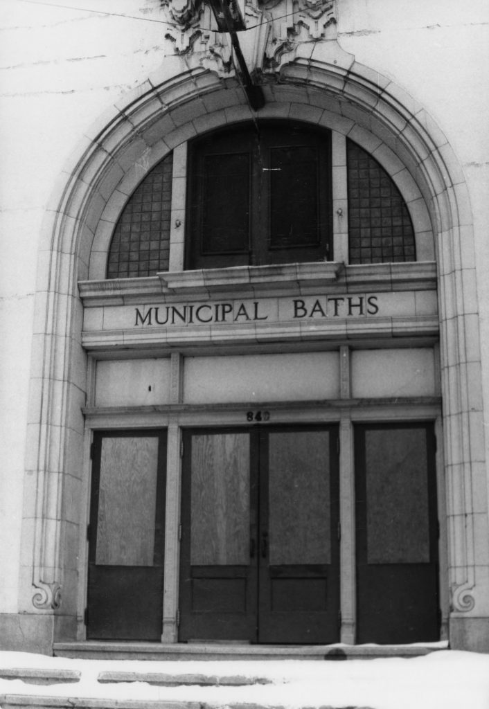
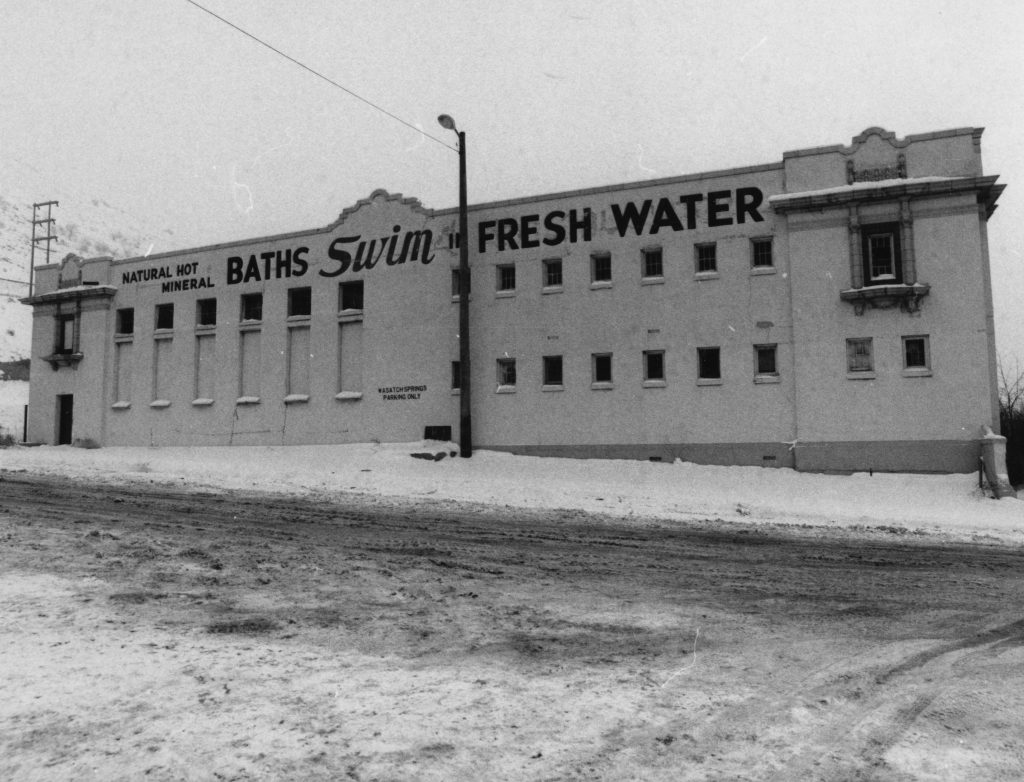
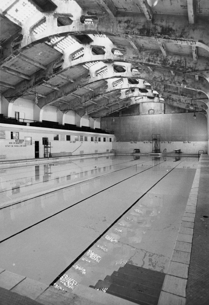
Built in 1921, the Wasatch Springs Plunge served as a municipal pool for fifty years, tapping into the natural hot springs at the far northern end of Salt Lake City. The building, located at 840 North and 300 West was built by noted architectural firm Cannon and Fetzer and is a striking example of Spanish Colonial Revival style architecture. In its heyday, the building had two pools, administrative offices, several private soaking tanks, a barbershop, a hairdresser, and men and women’s masseurs. Additionally, there were also five rooms available for overnight guests.[1]

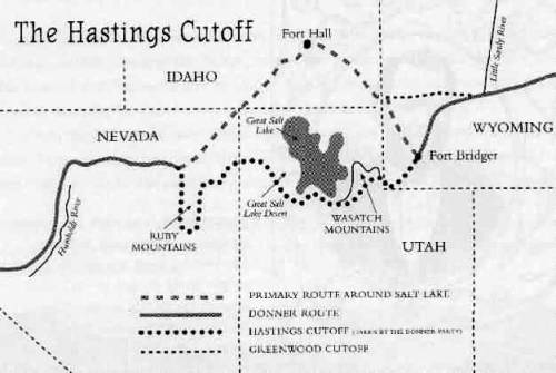
The Warm Springs have been utilized by all groups of people who call this region home. Historian Kathryn MacKay notes, “The 2-3 mile strip of hot springs and lake had been used for preceding centuries by the American Indians – Shoshones, Utes, Paiutes – who traveled through the area on hunting, foraging, trading, and social expeditions.”[2] It is likely that white fur trappers who were known to have visited the adjacent area also visited the springs. The first written encounter with the springs comes from a California-bound group, who followed Hastings Cutoff in 1846, and wrote of the warm water and its distinctly unpleasant odor. Erastus Snow, who, along with seven others, arrived in advance of Brigham Young’s wagon train, wrote about the Warm Springs on July 22, 1847. After describing the location, and the rocks nearby, he noted the temperature by writing, “We had no instrument to determine the degree of Temperature but suffice it to say that it was about right for scalding hogs.” Snow decided “The springs are the greatest facilities for a steam doctor I ever saw.” [3]

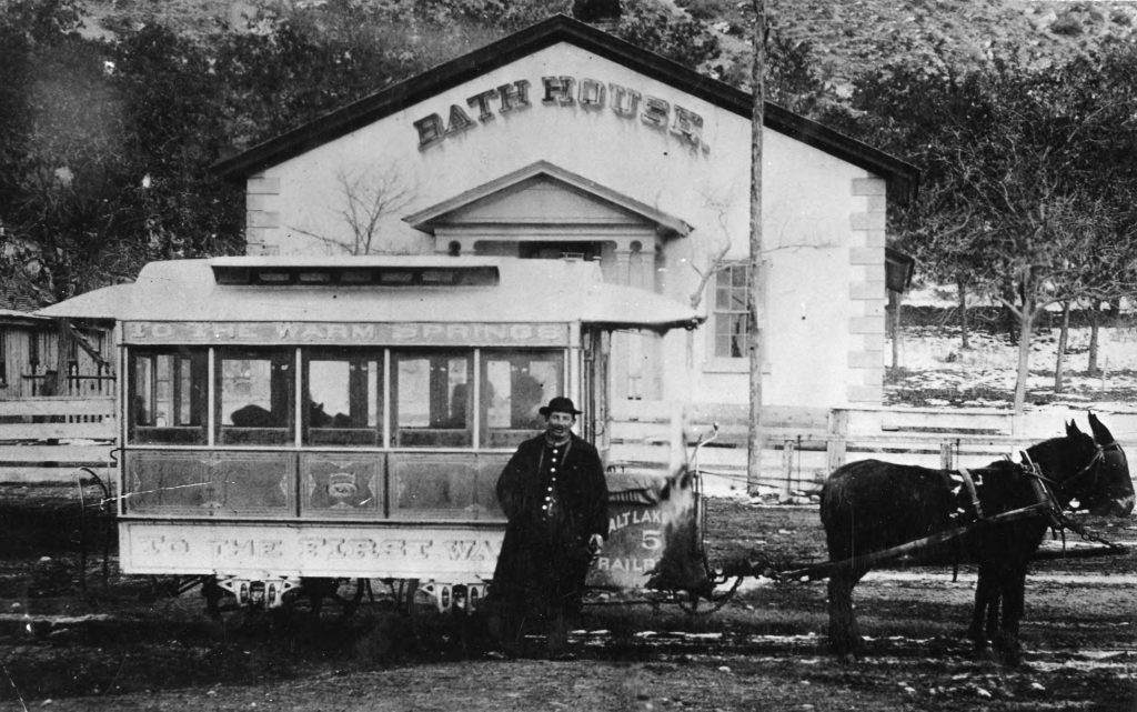
Classified Photograph Collection, “Warm Springs Bath House P. 1.” Courtesy Utah State History.

The permanent Euro-American settlement of the Salt Lake valley also marks the beginning of human-made structures intended to enhance the enjoyment of the natural springs. The springs were considered to have healing properties and were marketed not only for recreation but also for medicinal uses. In 1850, the Bath House opened and was within the purview of the neighboring Church of Jesus Christ of Latter-day Saints (LDS) 19th ward bishop’s responsibilities. By 1864, this building had fallen into disrepair and was no longer operated by the LDS Church. Over the next several decades the facilities were used for recreational purposes and, in 1916, Salt Lake City assumed ownership. It was at this point when the current structure was built and would remain in near-constant use for the next 85 years.

Classified Photograph Collection, “Warm Springs Bath House P. 15.” Courtesy Utah State History.
Classified Photograph Collection, “Warm Springs Bath House P. 14.” Courtesy Utah State History.
Classified Photograph Collection, “Warm Springs Bath House P. 16.” Courtesy Utah State History.

This period of the building’s history was not without problems. In 1946, concerns were raised over the sanitation of the water, and the city initially suggested chlorinating the pools. However, chlorine mixed with sulfur produces noxious chemicals, harmful to swimmers. As a compromise, the city decided to cap the natural hot springs, and the space was converted to a fresh-water, chlorinated pool.[4] Around that time, the pools began losing their appeal, and by the mid-1970s, they were no longer financially sustainable and were shuttered for nearly a decade before the Children’s Museum of Utah moved into the space in 1981.

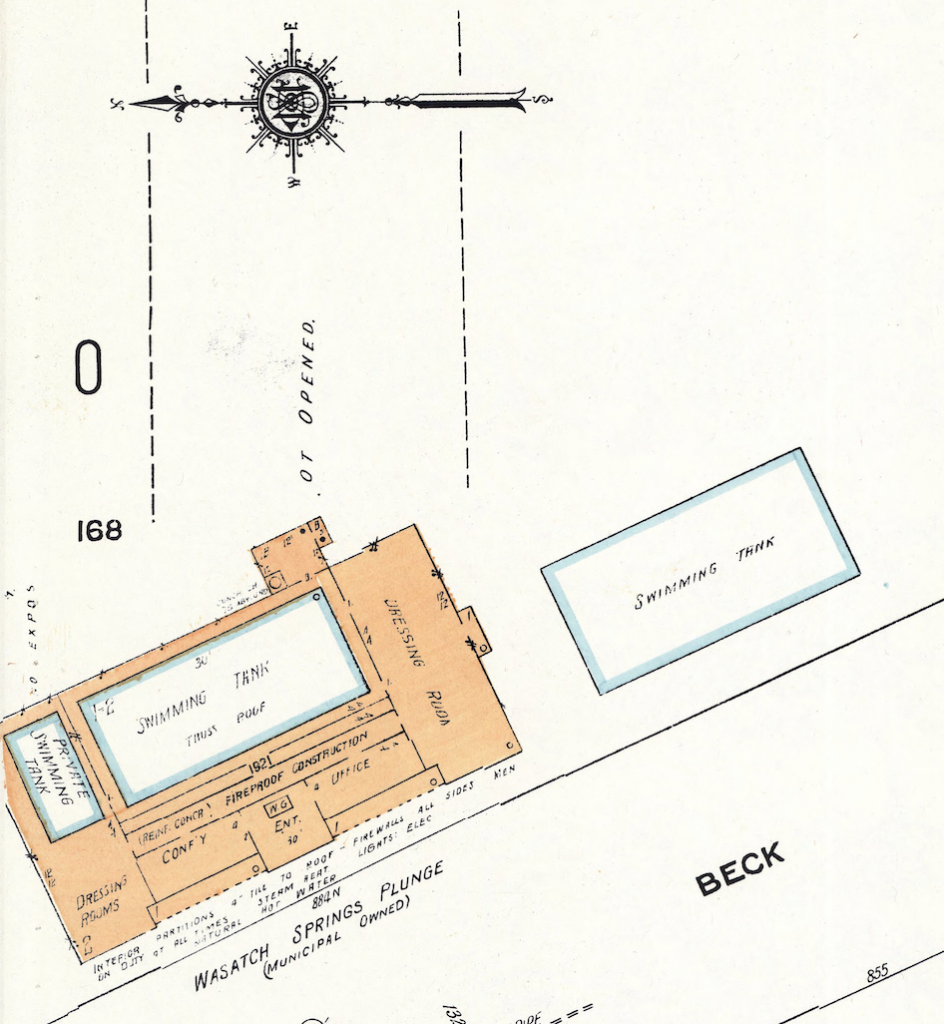
Sanborn Fire Insurance Maps, detail showing the Wasatch Springs Plunge in 1950. University of Utah Marriott Library, Print and Journal Division.

Today, the future of the building is unknown. Placed on the historic registry in 1980, the building has not been occupied full-time since the Children’s Museum of Utah moved out in 2006. The Golden Spike Train Club of Utah uses the space to house and work on their model railroad projects, but their future there is not guaranteed.[5] In 2016, Salt Lake City began accepting proposals for development, but eventually ruled out the possibility of putting housing on the site. A local organization, the Warm Springs Alliance, is advocating for the building to be used as warm springs once again.[6] However, this proposal faces significant financial hurdles. As of spring 2019, the building’s future is unknown, but there is no shortage of interest and enthusiasm for utilizing this historic gem in downtown Salt Lake.

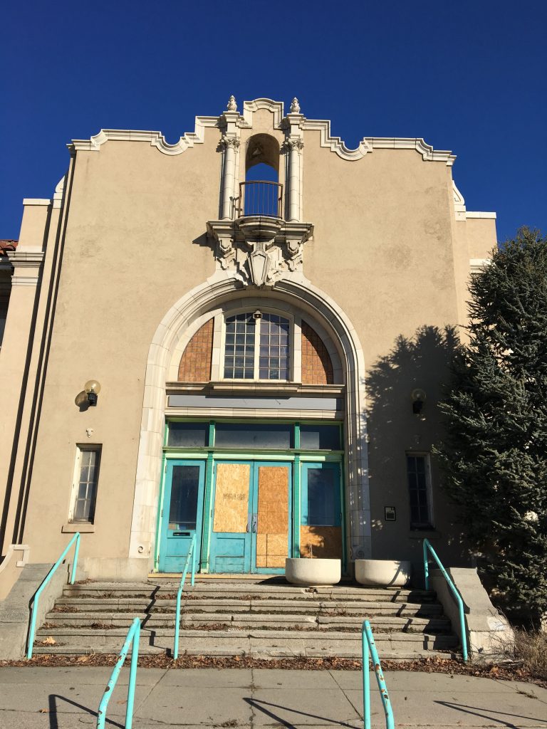
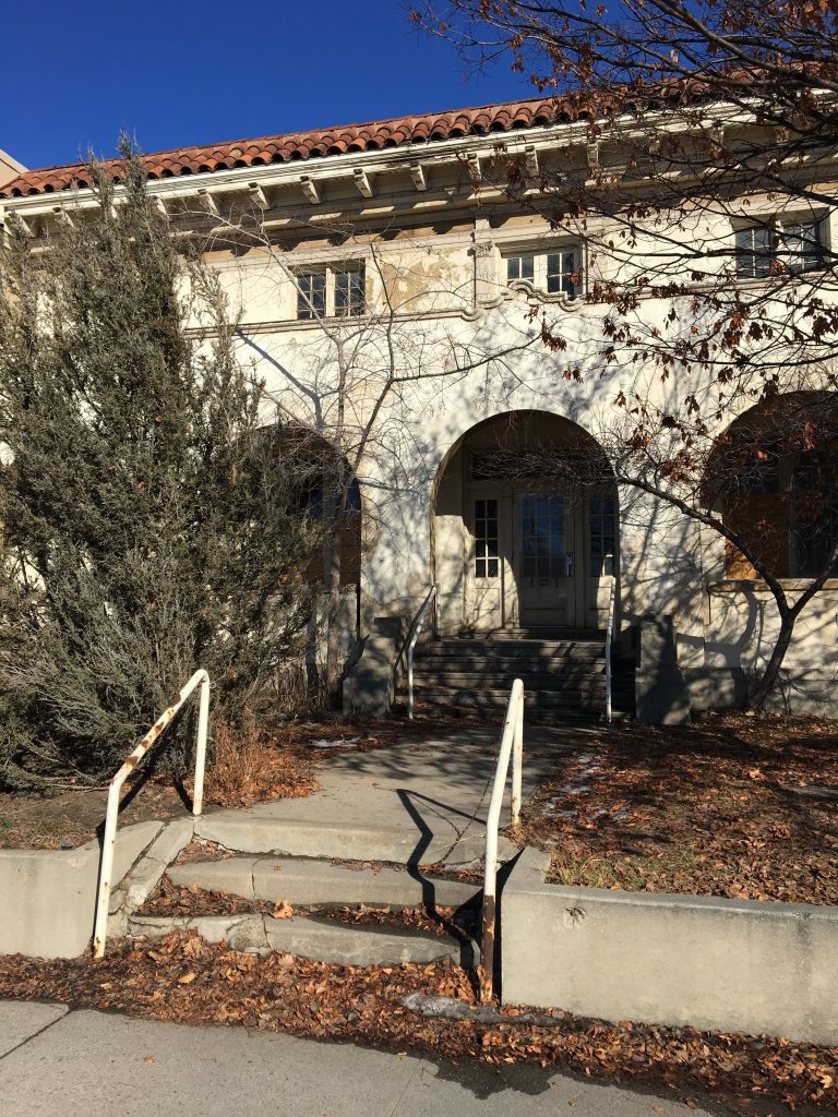
Wasatch Springs Plunge in February 2019.

For Further Reference:

Primary Sources:

Erastus Snow Journal, Church History Library, Church of Jesus Christ of Latter-day Saints, Salt Lake City.

Secondary Sources:

Lutz, Susan Juch. “Cleaned Up and Cleaned Out: Ruined Hot Springs Resorts of Utah.” GHC Bulletin (Energy and Geoscience Institute, University of Utah), 2004.

Jones, Darrell E. and W. Randall Dixon. “’It Was Very Warm and Smelt Very Bad’: Warm Springs and the First Bathhouse in Salt Lake.” Utah Historical Quarterly, Volume 76, Number 4 (2008): 212-226.

MacKay, Kathryn. “National Register of Historic Places Nomination Form: Wasatch Springs Plunge.” United States Department of the Interior Heritage Conservation and Recreation Service, 1980.

McFarland, Sheena. “Whatever happened to … Wasatch Springs Plunge?” The Salt Lake Tribune, December 23, 2014.

McLane, Michael. “The Children’s Museum.” Mapping SLC, http://www.mappingslc.org/this-was-here/item/243-the-children-s-museum.

McLane, Michael. “Past and Present Collide at Warm Springs.” Catalyst Magazine, December 1, 2017.


[1] Kathryn MacKay. “National Register of Historic Places Nomination Form: Wasatch Springs Plunge.” United States Department of the Interior Heritage Conservation and Recreation Service, 1980, 9.

[2] MacKay, “National Register of Historic Places Nomination Form,” 6.

[3] Erastus Snow Journal, July 22, 1847, as quoted in Darrell E. Jones and W. Randall Dixon. “‘It Was Very Warm and Smelt Very Bad’: Warm Springs and the First Bathhouse in Salt Lake.” Utah Historical Quarterly, Volume 76, Number 4 (2008): 212-226.

[4] MacKay, 9.

[5] Michael McLane. “The Children’s Museum.” Mapping SLC. http://www.mappingslc.org/this-was-here/item/243-the-children-s-museum. Accessed March 15, 2019. See also http://www.goldenspiketrainclubutah.org/ for information on the model train organization.

[6] http://www.warmspringsalliance.org/

First Church of Christ, Scientist, Salt Lake City

Published / by Gabe Martinez / 1 Comment on First Church of Christ, Scientist, Salt Lake City

Written by Gabe Martinez

Both markers placed by: The National Register of Historic Places, Division of State History

GPS Location: N 40° 45.755 W 111° 52.843

Historical Marker 1: No. S-28

Reads: First Church of Christ, Scientist, Salt Lake City: Organized July 17, 1891: Cornerstone laid June 4, 1898: Dedication November 27, 1898: Built of brick and kyune sandstone: Architect: W.E. Ware: First Christian Science Church established in Utah: Marker placed 1973

Marker placed by Division of State History
Taken by Gabe Martinez

Historical Marker 2: No. N-120

Reads:First Church of Christ, Scientist, The First Church of Christ Scientist in Utah was organized in Salt Lake City on July 17, 1891. The church, designed by architect Walter E. Ware, was constructed of brick and kyune sandstone. Dedicated on November 27, 1898, the building is the oldest Christian Science Church in Utah and one of the oldest continuously Christian Science Churches in the world.

Marker placed by Division of State History
Taken by Gabe Martinez

Extended Research:

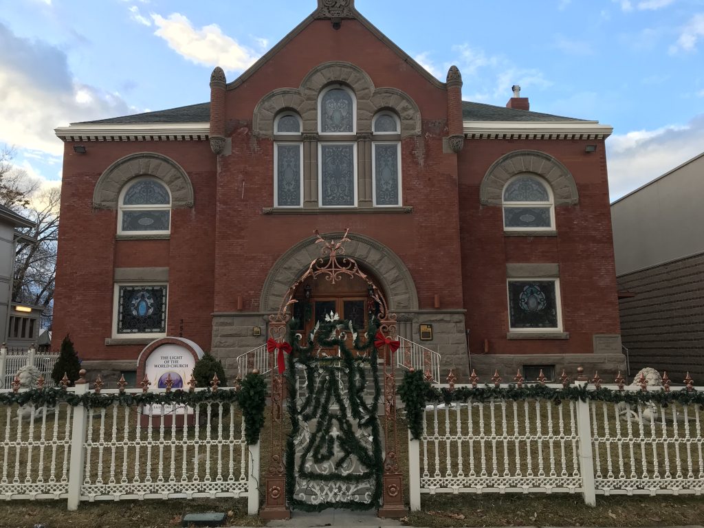
Front of the First Church of Christ Scientist building
Taken by Gabe Martinez

This building upon its dedication on November 27, 1898 housed The First Church of Christ, Scientist. The First Church of Christ, Scientist began in 1866 in Boston Massachusetts. The church was founded by Mary Baker Eddy through a healing experience with The Bible after a severe slip and fall [1]. Upon establishing the church, years later in 1879, Eddy received a state charter to create the Massachusetts Metaphysical College where the doctrine of Christian Science was taught to missionaries [3]. One of her students, Mrs. M. A. Bagley graduated and brought the doctrine to Salt Lake City. On July 17, 1891 in the home of Mrs. M.A. Bagley along with 10 other individuals (8 women and 3 men total) The First Church of Christ, Scientist was formed in Salt Lake [3]. This building was fully funded by donations of the congregation and with the help of Walter E. Ware as the architect [4]. At the time of dedication, the church was able to seat 650 people but more than 1000 would show up to the services from all across the western frontier, with Mrs. M. A. Bagley leading  the service [1]. Little is known about all the members of the congregation but stories of individual members do survive.

Second level of First Church of Christ, Scientist building
Taken by Gabe Martinez

One of these members is Anna K. Craig. In 1892, Craig travelled to Utah to teach kindergarten at Brigham Young Academy. Along with being a devout practitioner of Christian Science, Craig was also a member of the Utah Sororis Club, a nineteenth-century club in Provo, and a member of the first Board of Directors of the Woman’s Council [8]. Craig was one of many great women of not only the Christian Science Church but also her community. She played an active role in pushing the state to implement kindergarten in the Utah educational system [8].

In 1869, several years before the dedication of the First Church of Christ Scientist building, the first non-Latter-day Saint worship building, The Church of the Good Samaritan, in Corinne, UT was constructed. Following the Good Samaritan, the first Catholic Church in Salt Lake City was built in 1871 [6]. After that, in 1883, a Baptist church joined the growing list of new religious buildings [7]. These along with many others like the First Church of Christ, Scientist were a part of a worship space revival in Utah as faith began to diversify due largely to an influx of immigrants from diverse religious traditions who arrived in the state from the 1880s to the 1920s.

Inside of First Church of Christ, Scientist building. Original organ pipes
Taken by Gabe Martinez

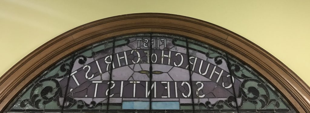
Most of the elaborate architecture and building features of the First Church of Christ, Scientist still stand today. For example the original organ and pipes remain but are not in use (pictured above). A majority of the wooden pews, including the ones on the second level, are original to the building (pictured above). All of the stained glass seen throughout the building is also original. Pictured below is the original stain glass window which reads “First Church of Christ Scientist” that can only be seen from the inside of the building.

Inside view of the front entrance stain glass of the First Church of Christ, Scientist building
Taken by Gabe Martinez

This building now houses The Light of the World Church (La Luz Del Mundo). The Light of the World Church is not affiliated with the First Church of Christ, Scientist or Christian Science. In 2002, members of the First Church of Christ, Scientist sold the historic building largely due to changing demographics in the congregation and a move from downtown Salt Lake City to other areas of the state. The building then became home to Anthony’s Fine Art and Antiques. In 2006, The Light of the World Church purchased the building from Anthony’s.

In 2019, Christian Science churches in Utah have active congregations in the Salt Lake City area, Ogden, and Park City [5].

Primary Sources:

[1] Eddy, Mary Baker, 1821-1910, and Scientist First Church of Christ. The Christian Science Journal. Boston: The Christian Science Publishing Society

Secondary Sources:

[2] Johnson, Jeffery Ogden. “Lucretia Heywood Kimball (1856–1920): Pioneer in Utah’s Early Christian Science Movement.” Worth Their Salt Too: More Notable But Often Unnoted Women of Utah, edited by Colleen Whitley, University Press of Colorado, 2000, pp. 55–60. JSTOR, .http://www.jstor.org/stable/j.ctt4cgpjz.7

[3] Cannon II, Kenneth L. “Brigham Bicknell Young: Musical Christian Scientist.” Utah Historical Quarterly 50.2 (1982): 124-38.

[4] United States Government, National Register of Historic Places Collection, First Church of Christ Scientist, 30 July 1976, https://npgallery.nps.gov/NRHP/AssetDetail?assetID=005ff433-712f-44ef-bd56-4ac9d0530b39

[5] https://en.wikipedia.org/wiki/Church_of_Christ,_Scientist#Recent_problems; Elizabeth Beall, Christian Science Committee on Publication for Utah.

[6] http://www.ereferencedesk.com/resources/state-history-timeline/utah.html

[7] http://www.firstbaptist-slc.org/find-out-more/church-history/

[8] Ventilla, Andrea. “Woman and the Kindergarten Movement in Utah”. Utah Historical Quarterly 81. 1-4 (2013) 133-150.

Joseph F. Steenblik Park

Published / by Juli Huddleston / Leave a Comment

Write-up by Julia Huddleston

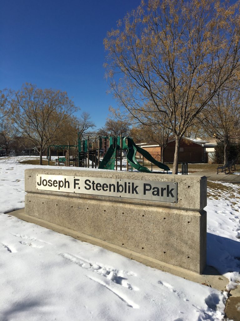
View of Steenblik Park, February 2019.

GPS Coordinates: 40.787, -111.92H

Historical Marker Text:

Joseph F. Steenblik was a friend of youth and a builder of men in cultural, physical, and spiritual activities. Born in Salt Lake City, Utah in 1904, he lived in the Rose Park area since 1908. Over the years, Joseph promoted many scout activities, such as Scout-O-Rama, and chaired scout fund drives. In addition to his support of the Boy Scouts, Joseph recognized that girls need outdoor outings as much as boys. He was instrumental in the organizing and building of the Rose Park Library, Rose Park Gymnasium, and the local church Stake House. He was a good example of a Good Samaritan, kind to the less fortunate, good to his employees, and exemplified the values of dependability and hard work.

Open 8:00 A.M. to 11:00 P.M.

Leashed dogs only

No alcoholic beverages

Dairy Cats

2007

Day Christiansen

The “Dairy Cats” were developed with the Steenblik Dairy, a longtime presence in the Rose Park Neighborhood, in mind. The cats are sited so children and adults can enjoy them as they visit or walk through Steenblik Park. The four cats are cast in bronze with variations in patina resulting in a diversity of colors combined with the classic richness of bronze.

“Dairy Cats” is a project of the Salt Lake City public art program, managed by the Salt Lake City Arts Council under the direction of the Salt Lake City Art Design Board. Thanks to the neighborhood representatives who assisted with the project, and also to the City Council member Carlton Christensen, Rose Park Community Council, SLC Parks, SLC Housing and Neighborhood Development, SLC Engineering, and the Department of Community Development.

Dairy Cats by Day Christiansen.

Extended Research:

Joseph F. Steenblik Park is a pocket park located in the heart of the vibrant and closely-knit Rose Park neighborhood in the northwest quadrant of Salt Lake City. Real estate developer Alan Brockbank gave Rose Park its name after he saw a corner market store with blooming rose bushes, which the storeowner credited to the fertile soil in the area. Inspired by the roses, Brockbank gave the new streets names of unusual rose varieties such as American Beauty, Rambler, Talisman, Sonata, Autumn, Debonair, and Nocturne.[1] Rose Park consists primarily of one-story red brick houses, with an architectural cohesion not often found in Salt Lake’s other older neighborhoods.

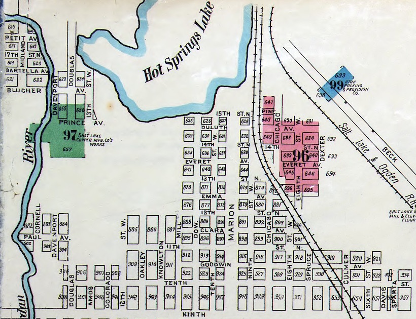
Even though many of the homes are close to seventy years old, this is not the first housing development to occupy the space. By 1911, the Oakley Park subdivision had become home to many railroad employees of various races, ethnicities, and religious backgrounds due to the proximity to the railroad yards outside downtown Salt Lake City. However, by the mid-1940s the neighborhood was badly blighted, and the health department gave residents an ultimatum to “rid themselves of a collection of horses, cows, stray dogs, hogs, ducks, turkeys, chickens, and goats” or move elsewhere.[2] Brockbank, who created the master plan for the new 2,000-home Rose Park subdivision in 1946, expedited this cleanup effort to meet the post-WWII demand for affordable housing for growing families. While not initially wholly positive for the residents (the new subdivision implemented regrettable restrictive covenant clauses prohibiting people of color from purchasing homes), the area rebounded and is once again welcoming and inclusive, boasting one of the highest rates of racial and ethnic diversity in the Salt Lake valley.[3]

Detail from Sanborn Fire Insurance map showing the Oakley Park subdivision in 1911. Marriott Library Special Collections, Print and Journal Division.

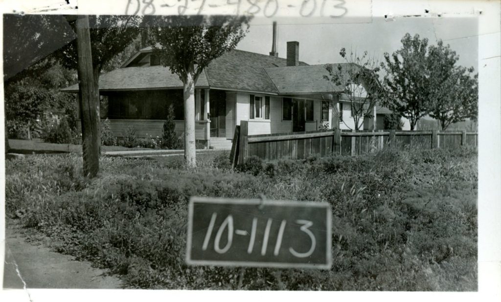
Throughout all these changes, the Steenblik family proved to be a consistent and influential presence in the neighborhood. Joseph F. Steenblik, along with his extended family, was instrumental in both the history and growth of the area. Born in 1904 in Salt Lake City, his parents had emigrated from the Netherlands the year previously. The family moved to Rose Park in 1908, where Joseph and several siblings lived for much of their lives. The family owned and operated Steenblik Dairy, a small-scale dairy farm that supplied milk to Salt Lake’s west side.[4] The dairy, which was located adjacent to the family home at 1442 W. Leadville Avenue, was established around 1920 and was operational into the 1970s. [5] After serving a mission for the Church of Jesus Christ of Latter-day Saints (LDS) to Holland, Steenblik married Ruth Reid, and the couple had seven children.

Joseph F. Steenblik’s home, adjacent to Steenblik Dairy. Tax assessment photograph, 1936. Courtesy Salt Lake County Archives.

In addition to working on the family dairy farm, Joseph, alongside his brother Roelof, operated a construction company—Steenblik Construction—which was incorporated in 1952. They were instrumental in aiding with the construction of the Rose Park Stake House, an impressive and unusually large meeting place for the local Latter-day Saint congregations. The building has two chapels, allowing for simultaneous worship services, two meeting halls for social gatherings, a courtyard, a gymnasium, as well as a detached recreation building. Steenblik served as the Stake president (an ecclesiastical position roughly equivalent to a bishop over a Catholic diocese) in addition to other important religious leadership roles.[6] Joseph F. Steenblik died in 1991, at the age of 87.

Steenblik Dairy, commercial tax assessment photograph, 1978. Salt Lake County Archives.

The Joseph F. Steenblik Park was built in 1984 with federal block grant funding, and was named in the “Name the Park” competition proposed by Mayor Palmer DePaulis.[7] In 2007 Salt Lake City commissioned local artist Day Christiansen to create a work of public art that would be emblematic of the neighborhood. Paying homage to Steenblik Dairy, his sculpture Dairy Cats consists of four five-foot tall bronze statues of seated cats that represent mouser cats often found on farms. The park pays tribute to Joseph F. Steenblik and his family’s lasting legacy in Rose Park. His influence is still visible throughout the neighborhood, and has contributed to the vibrancy and resiliency of the community.


[1] Charles L. Doane, Leo W. Russon, Archie S. Hurst, Salt Lake Rose Park Stake History 1955-1980: A Sesquicentennial Project,(Salt Lake City, Utah: Salt Lake Rose Park Stake, Inc. 1980).

[2] Richard W. Bernick, “S. L. Demands West Side Area Cleanup,” Salt Lake Telegram, 6 August, 1948.

[3] Chris Dunsmore, “Rose Park,” Mapping SLC, http://www.mappingslc.org/this-was-here/item/151-rose-park, March 7, 2019.

[4] “Roelof Steenblik Obituary,” Salt Lake Tribune,  December 26, 2002.

[5] Doane, Russon, and Hurst, Salt Lake Rose Park Stake History 1955-1980: A Sesquicentennial Project, Salt Lake City, Utah: Salt Lake Rose Park Stake, Inc. 1980, 2.

[6] Doane, Russon, and Hurst, (Salt Lake Rose Park Stake History) 207.

[7] Susan Lyman, “Mini-Parks Neighborhood Folk Heroes Find Their Place in the Shade,” Deseret News, August 28, 1988. Accessed via the Deseret News online archive.

For Further Reference:

Primary Sources:

Richard W. Bernick. “S. L. Demands West Side Area Cleanup.” Salt Lake Telegram, 6 August, 1948.

Alan Brockbank papers, Ms 604, Marriott Library Special Collections, University of Utah.

“Roelof Steenblik Obituary.” Salt Lake Tribune.  December 26, 2002.

Salt Lake County Tax Assessment Records, Salt Lake County Archives.

Sanborn Fire Insurance Maps, University of Utah Marriott Library.

Secondary Sources:

Doane, Charles L., Leo W. Russon and Archie S. Hurst. Salt Lake Rose Park Stake History, 1955-1980: A Sesquicentennial Project. Salt Lake City: Salt Lake Rose Park Stake, 1980.

Dunsmore, Chris. “Rose Park.” Mapping SLC, http://www.mappingslc.org/this-was-here/item/151-rose-park. March 7, 2019.

Lyman, Susan. “Mini-Parks: Neighborhood Folk Heroes Find Their Place in the Shade.” The Deseret News, August 28, 1988.


Donner Hill

Published / by William Root / 2 Comments on Donner Hill

Placed by: LDS 38th North Ward Priests[1]

GPS Coordinates: 40° 45’5.76″N, 111° 48’3.28″W

Historical Marker Text:
Lured by Lansford Hasting’s assurance that his shortcut from the well-known trail to Oregon and California would save 250 miles and weeks of travel, the ill-fated Donner-Reed party reached this place August 23, 1846, after spending 16 days to hack out a 36-mile road through the Wasatch Mountains. Here at this narrow mouth of the canyon, they were stopped by what seemed impenetrable brush and boulders. Bone-weary of that kind of labor, they decided instead to goad the oxen to climb the hill in front of you. Twelve-year-old Virginia Reed, later recalled that nearly every yoke of oxen was required to pull each of the party’s twenty-three wagons up the hill. After this ordeal, the oxen needed rest, but there was no time. The party pushed on to the Salt Flats, where many of the oxen gave out. This caused delays, which led to disaster in the Sierra Mountains.

A year later, July 22, 1847, Brigham Young’s Pioneer Party, following the Donners and benefitting from their labor, reached this spot. William Clayton recorded their decision: “We found the road crossing the creek again to the south and then ascending a very steep, high hill. It is so very steep as to be almost impossible for heavy wagons to ascend…Colonel Markham and another man went over the hill and returned up the canyon to see if a road cannot be cut through and avoid this hill. Brother Markham says a good road can soon be made through the bushes some ten or fifteen rods. A number of men went to work immediately to make the road…After spending about four hours of labor the brethren succeeded in cutting a pretty good road along the creek and the wagons proceeded on.”

Donner Hill looking east towards Emigration Canyon

Among the lesson learned that day was one stated succinctly by Virginia Reed in a letter to prospective emigrants back home: “Hurry along as fast as you can, and never take no shortcuts.”

Extended Research:

In 1846 a wagon party led by George Donner departed Independence, Missouri and began a perilous journey from the United States towards Alta California in Mexico. The wagons were late in reaching the Sierra Nevada mountain range and disaster awaited the 88 members of the Donner Party. Extreme suffering and starvation followed, with 41 members of the group dying and eventually the incident drew national attention over reports that some members of the ill-fated party resorted to cannibalism in order to survive.[2] The Donner Party originally planned to travel to California via Oregon, but real estate speculator Lansford Hastings promoted an alternate route published in his famous Emigrants Guide to Oregon and California in 1845, and the Donner Party opted to try it.³

Hastings was not certain if he should promote the cutoff from Fort Bridger through the Salt Lake Valley and westward following John C. Fremont’s expedition in 1845, but he received support in favor of the cutoff from Fremont and Jim Bridger. Hastings thus advised the Donner-Reed party that they would save some 350-400 miles if they took his “cutoff.” One of his partners, James Clyman, however became convinced that the route was not suited for wagons and therefore tried to dissuade members of Donner-Reed Party from taking the cutoff. Joseph R. Walker, who successfully guided the first wagons over the California Trail by way of Fort Hall, also thought the route an unproven risk.[3]

Other migrant groups, which included the Bryant-Russell Party and Harlan-Young wagons, left Fort Bridger in mid-July 1848, following the Bear River into East Canyon where they passed through Devil’s Gate with difficulty along the Weber River. Hastings subsequently directed a group of German migrants from the Heinrich Lienhard party on a direct route through Echo Canyon into Devil’s Gate, where they caught up with the Harlan-Young party near the Jordan River. The Donner Party departed Fort Bridger two weeks later on July 31 and Hastings talked them out of going via Weber Canyon and Devil’s Gate, instead telling them to blaze a new path over to what would come to be called Emigration Canyon. On August 7, 1846, James Reed began carving a trail for the wagon train, chopping down bushes and trees in the Wasatch Mountains towards the canyon. Reed was joined by the remaining members of the wagon party who continued to hack and dig their way for 35 miles from present-day Henefer, Summit County, to Salt Lake City.²

Emigration Creek along Donner Hill

The Bryant-Russell, Harlan-Young and Lienhard parties would successfully pass through the Sierra Nevada Mountains into California, while the time the Donner Party spent trailblazing in Utah foreshadowed later events. After the three week trek through the Wasatch Mountains, the oxen were already exhausted and their supplies began to run low.

After entering the Salt Lake Valley, the first member of the party died of tuberculosis near the Great Salt Lake. A site near Grantsville, Utah provided temporary relief with underground water springs, their last source of water until reaching the Humboldt River. In the Salt Flats, Reed’s thirsty oxen ran off and were never seen again. Upon reaching Iron Hill, a fight broke out between one of Reed’s teamsters and John Snyder, a driver for the Graves wagon. Reed stabbed Snyder in the chest and was banished by the Donners after Snyder died. Reed thus avoided being pinned down by the early winter storms which trapped the rest of the party. His departure in October towards Sutter’s Fort allowed him to organize a rescue party in Sacramento that arrived in February 1847. Along the Humboldt River a band of Paiute Indians killed 21 of the Donner Party’s oxen and stole another 18, with more than 100 of the party’s cattle now gone. Two Indian guides assisted the Donner Party in reaching the summit of the Sierra Nevada, but turned back with the first sign of snowfall in early November.1

Donner-Reed Party burial remains discovered in the Salt Lake Desert

The delayed timing and trek through the west desert led to the party becoming snowbound in the Sierras. Malnutrition was a common cause of death, and Irish immigrant Patrick Breen wrote in his journal on Christmas Eve that he was living in a “Camp of Death”. 1 Some of the members of the party camped along the banks of Alder Creek and frozen Truckee Lake, now Donner Lake, where most of the cannibalism occurred. The first rescuers arrived at Truckee Lake in February 1847, composed of soldiers from the U.S. Army stationed in California during the U.S.-Mexican War, among them were members of the Mormon Battalion. One week after rescuers arrived, other isolated camp sites were still using the corpses of the dead for food. Breen wrote in his diary on February 26:

Martha’s jaw swelled with the toothache: hungry times in camp; plenty hides, but the folks will not eat them. We eat them with a tolerable good apetite. Thanks be to Almighty God. Amen. Mrs Murphy said here yesterday that [she] thought she would Commence on Milt. & eat him. I don’t [think] that she has done so yet; it is distressing. The Donners, 4 days ago, told the California folks that they[would] commence to eat the dead people if they did not succeed, that day or next, in finding their cattle.1

Patrick Breen’s diary entry describing the routine cannibalism in the encampment

Three additional relief efforts occurred in April in an attempt to find members who had become separated while camping along Truckee Lake. In the last effort they found only one survivor, Louis Keesberg, who was surrounded by half-eaten corpses. As the survivors departed with the rescuers, members of the Mormon Battalion were ordered to bury the dead bodies inside the main cabin on what is today Donner Pass and then set fire to the cabin.[4]

The Donner Party, in essence, blazed the trail into the Salt Lake Valley which Brigham Young and the Mormon Pioneers used the following year. Young left Winter Quarters, Nebraska with his encampment and passed through the mouth of Echo Canyon by mid-July 1847; he then picked up the Donner-Reed trail and followed it into the Salt Lake Valley. Instead of three weeks, it took Young’s party one week, a matter of great importance since it enabled the Mormons to plant wheat and potato crops in time for their first harvest in the fall. In the last quarter-mile, rather than hauling their wagons over Donner Hill, the Mormons decided to hack through the brush and go around Donner Hill. The Mormons emerged four hours later at what is now This is the Place State Park.[5]

For Further Reference:

Primary Sources:

Breen, Patrick. Diary of Patrick Breen of the Donner Party, 1846-7. Berkeley: University  of         California Bancroft Library, 1910.

Secondary Sources:

Campbell, Eugene. “The Mormons and the Donner Party.” BYU Studies Quarterly, Vol. 11 no. 3 (1971).

Miller, David. “The Donner Road through the Great Salt Lake Desert.” Pacific Historical Review, Vol. 27, no. 1 (February 1958): 39-44


[1] Originally installed by “Mormon Explorers” Y.M.M.I.A. In 2010, the original plaque was stolen and re-erected in 2016 by the LDS 38th North Ward High Priests

[2] Campbell, “The Mormons and the Donner Party.”

[3] Miller, “The Donner Road through the Great Salt Lake Desert,” 39-44

1 Breen, 18

1 Breen, 28

[5] Campbell, “The Mormons and the Donner Party.”

James E. Talmage Building

Published / by Courtney Edwards / Leave a Comment

Write up by Courtney Taylor

James E. Talmage Building

Placed by: The University of Utah Alumni Association

GPS Coordinates: Latitude: 40º 45’  51.702” N Longitude 111º 50’ 58.59” W

Historical Marker Text

James E. Talmage-scholar, scientist, educator, author, and church leader-was born in England and came to Utah when he was ten years old. He earned the A.B degree at Lehigh University. and the Ph.D at Illinois Wesleyan University. For his work in chemistry and geology he was elected to membership in the Royal Society of Edinbirgh. He gave vigorous leadership to the University as Professor of metallurgy and biology, as Deseret professor of geology and as the University’s second president from 1894 to 1897. His major educational concern was to build a sound system of teaching for the people of Utah who, in the 1880’s were still somewhat remote from the established centers of learning, and to incorporate into the University curriculum the expanding body of scientific knowledge.

The land on which this building stands was deeded to the University during President Talmage’s administration. Construction of the building, to be known as the Museum, was begun in 1900, but so many new buildings were going up in Salt Lake City that skilled laborers and quality brick and stone were in short supply. The building was not completed until late in 1902.

The Museum building contained classrooms, offices and laboratories for biology, geology and mineralogy; geological and biological museums; an assembly room and gymnasium. About 1920, geology classes were relocated and the Museum become known as the Biology Building until, on June, 1976 in ceremonies sponsored by the Alumni Association, it was officially named the James E. Talmage building.

Extended Research:

James E. Talmage was a respected member of the academic community as well as a leader in the Church of Jesus Christ of Latter-day Saints. Talmage was the fourth president of The University of Utah from 1894-1897 but it was not until 1976 that the building was named the James E. Talmage building.

Talmage had a life full of educational and academic success. He grew up in Provo, Utah and worked at Brigham Young Academy (now Brigham Young University). He had a love of knowledge and pursued degrees in chemistry and geology. He studied at Leigh University and Johns Hopkins University. He became one of the first Mormons to receive a PhD.1 After his time as president of the University of Utah he was called to the Quorum of the Twelve Apostles of the Church of Jesus Christ of Latter-day Saints. While he was an apostle he also published a book well known in the Church called Jesus the Christ. 

He took his job as University of Utah president very seriously and in correspondence with Elder John M. Whitaker he mentioned that it was “hard for me to do any lecturing outside the regular lectures at the institution”.2 He worked hard and he accomplished a lot in his academic life and took his job very seriously as president of the university. He was busy in his church life as well as home life as he was a father to eight children. Eventually he died from inflammation of the heart on 21 July 1933.3

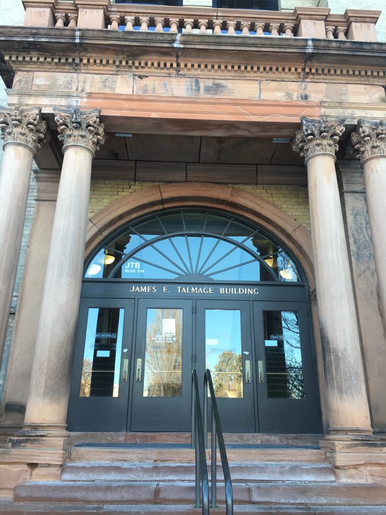
The James E. Talmage building’s purpose changed over time. It was first erected as a museum building in 1902 but has primarily served as a science building. The building was built by architects Samuel C. Dallas and Williams S. Hedges who designed the building in a second renaissance revival style as the unique columns in the front of the building attest.4

The medical school took over use of the building from 1905-1920. In 1959 it was changed to the biology building to accommodate classrooms for a growing student population. Then in 1976 the building was renamed the James E. Talmage building in honor of the former university president. It is located in President’s Circle and the building is still used for science related studies.5

1 Bowman, Matthew Burton. The Mormon People: The Making of an American Faith. New York: Random House, 2012.

2 “Correspondence between John Mills Whitaker and James E. Talmage.” James E. Talmage to John Mills Whitaker. January 25, 1894.

3 Hardy, Jeffery S. “Mormon Missionary Diaries.” https://lib.byu.edu/collections/mormon-missionary-diaries/about/diarists/james-edward-talmage/

4 1992. https://preservationutah.org/images/stories/education/uofupresidentscircle.pdf.

5 “James E. Talmage Building | History of the Health Sciences.” J. Willard Marriott Digital Library. https://collections.lib.utah.edu/ark:/87278/s6p87n57

Primary Sources

1992. https://preservationutah.org/images/stories/education/uofupresidentscircle.pdf.

“Correspondence between John Mills Whitaker and James E. Talmage.” James E. Talmage to John Mills Whitaker. January 25, 1894. https://collections.lib.utah.edu/details?id=917332

Secondary Sources 

Hardy, Jeffery S. “Mormon Missionary Diaries.” https://lib.byu.edu/collections/mormon-missionary-diaries/about/diarists/james-edward-talmage/

“James E. Talmage Building | History of the Health Sciences.” J. Willard Marriott Digital Library. https://collections.lib.utah.edu/ark:/87278/s6p87n57.

“James E. Talmage (1862–1933).” James E. Talmage (1862–1933). https://www.lds.org/study/ensign/2010/03/small-and-simple-things/james-e-talmage-1862-1933?lang=eng.

“James E. Talmage Building.” Digital image. https://collections.lib.utah.edu/details?id=1036000.

The Pony Express Station

Published / by Gloria Aceves / 2 Comments on The Pony Express Station

GPS coordinates: N 40’ 39.391’ W 111’ 52.713

Address: 5189 South State Street, Murray, UT 84107

Erected in 1960 by the Daughters of Utah Pioneers association.

Historical Marker Text : The Pony Express epoch began simultaneously April 3, 1860 with riders starting at St. Joseph, Missouri, and San Francisco, California. It was a 1966 mile journey and reduced the time of transmitting news across the country from approximately 21 to 10 days. Nearly one hundred stations were established. This spot marks the first station south of Salt Lake City. It was a small adobe building known as Travelers’ Rest. Here riders exchanged horses and received needed repairs, food, or lodging. With the inception of telegraph the pony express was abolished in October, 1861.

Extended Research

Distributing mail was a difficult and expensive task in the nineteenth century, especially from the eastern United States to the West. It was also a dangerous task due to the challenging terrain, harsh weather, and potential attacks from bandits. Designed to meet these challenges and overcome them, the United States contracted with a major American freight company, Russell, Majors, and Waddell, which established the Pony Express in April 1860. There were multiple express stations built between San Francisco, California and St. Joseph’s, Missouri. At these stations riders could get a fresh horse, rest, obtain food, and hurry on their way. It normally took more than three weeks by stagecoach to deliver the mail but the Pony Express made it possible to travel nearly 2,000 miles within ten days [1].

Although the Pony Express was very successful, there were still some dangers that the riders faced. There were some people who would try to steal the mail that the riders carried with them, sometimes resulting in violence. A Pony Express rider named George S. Stiers stated in one of his journal entries, that he encountered multiple men who tried to steal from him while on his way to deliver mail [2]. He worked as a mail carrier for three years but had to quit because the man who hired him didn’t want to be at fault for Stiers’ death during the delivery of mail.

Photo Credit: www.Nationalgeographic.org [3]

Utah Territory was an important crossroads on the Pony Express route. “Salt Lake City was a major population center between the Missouri River and the West Coast” [5]. The Kansas based mail delivery firm, Russell, Majors, and Waddell created the Pony Express stations between St. Joseph’s, Missouri and Salt Lake City and from there to Sacramento.[4]. Most of the men who delivered the mail were young and some of them were from Salt Lake City. With Utah Territory’s population of around 40,000 people in 1860, the Pony Express carried many letters from the territory. In total, the Pony Express managed to deliver over 30,000 letters during the eighteen months that it was in business.

The Saddles that carried the mail

The Pony Express was successful in reducing the time it took to receive mail  but it was not profitable. The completion of the transcontinental telegraph in October 1861 meant that the Pony Express was no longer needed. According to a journal entry by Captain J.H. Simpson, the telegraph used the same basic trail that the Pony Express had used and converted some of the Pony Express stations into telegraph stations [6]. 


Flyers requesting men to work in the Pony Express

The Pony Express should be remembered as an important advance in speeding the time it took to get news and information across the United States. At the time, nothing had ever been delivered so fast as the mail with the Pony Express. In the twenty first century, there are many methods to deliver things quickly like airplanes or cellphones. The fast delivery of the Pony Express was an important innovation for the nineteenth century like cell phones and airplanes are for people today. The Pony Express is also a symbol of the old West, especially an iconic man on a horse racing across the desert. It symbolizes masculinity, strength, and conquest and embodies many of the myths of the West.

The Pony Express Station in Murray, Utah was significant enough to get its own historical marker because it was one of the places where the riders could stop and relax. There were some stations that were dangerous due to their location, but the station in Murray was known for its safety and as a good place to rest. It was also the first station South of Salt Lake City to be established.

[1] Frank, Megean Van. “The Pony Express in Utah.” Home – Utah Humanities, 13 Aug. 2010, https://www.utahhumanities.org/stories/items/show/193

[2] Gauthier, Sheldon F, and George S Stiers. George S. Stiers. Texas. Manuscript/Mixed Material. https://www.loc.gov/item/wpalh002423/.

[3] Gunther, Tim. “Pony Express Route.” National Geographic Society. November 09, 2012. https://www.nationalgeographic.org/maps/pony-express/.

[4] Carter, Kate B. Utah and the Pony Express. Daughters of the UtahPioneers, 1988. URL: https://hdl.handle.net/2027/mdp.39015013918506

[5] Stuart, Wendy. “The Pony Express in Utah Book Signing.” Park City Museum. April 01, 2015. http://parkcityhistory.org/the-pony-express-in-utah-book-signing/.

[6] Captain J. H. Simpson. Made by Authority of the Secretary of War and under Instructions from Bvt. Brig. Gen. A. S. Johnston., 1876. https://archive.org/details/reportofexplorat00simp/page/n10


For Further Reference:

Primary Sources:

Gauthier, Sheldon F, and George S Stiers. George S. Stiers. Texas. Manuscript/Mixed Material. https://www.loc.gov/item/wpalh002423/.

Simpson, J. H. Report of Explorations across the Great Basin of the Territory of Utah :for a Direct Wagon-Route from Camp Floyd to Genoa, in Carson Valley, in 1859 /by Captain J. H. Simpson. Made by Authority of the Secretary of War and under Instructions from Bvt. Brig. Gen. A. S. Johnston., 1876. https://archive.org/details/reportofexplorat00simp/page/n10

Secondary Sources:

Frank, Meghan Van. “The Pony Express in Utah.” Home – Utah Humanities, 13 Aug. 2010, www.utahhumanities.org/stories/items/show/193.

Gunther, Tim. “Pony Express Route.” National Geographic Society. November 09, 2012. https://www.nationalgeographic.org/maps/pony-express/.

Stuart, Wendy. “The Pony Express in Utah Book Signing.” Park City Museum, 1 Apr. 2015, www.parkcityhistory.org/the-pony-express-in-utah-book-signing/

Carter, Kate B. Utah and the Pony Express. Daughters of the Utah Pioneers, 1988. URL: https://hdl.handle.net/2027/mdp.39015013918506

Fike, Richard E., and John W. Headley. The Pony Express Stations of Utah in Historical Perspective. Dept. of the Interior, Bureau of Land Management, 1979. URL: https://hdl.handle.net/2027/umn.31951002854172y

Bogan Boarding House

Published / by Peter Lewis / Leave a Comment

write-up by Peter G. Lewis

GPS Coordinates:

            Latitude: 40.6410322

            Longitude: -111.49453919999999

Marker Text (Placed by the Division of State History for the National Register of Historic Places):

“The Bogan Boarding House, built in 1904, was established as a boarding house for miners after the passage of the mine boarding house bill in 1901. Prior to 1901, single miners were required to live in the company owned boarding houses close to the mines. After passage of the bill, finer accommodations such as this boarding house were allowed to be built in Park City proper to accommodate the influx of single miners. None of the boarding houses that were built close to the mines have survived and this is one of only four existing boarding houses in the entire Park City area to have survived to the present. Known for many years as the Imperial Hotel, this building served primarily as a boarding house for miners, but during the 1918 flu epidemic it was used as an emergency hospital.  Marker placed in 1985.”

Picture of the historical marker itself. Captured 1/19/2019.
The structure in present day. Captured 1/19/2019.

Extended Research:

Publication of The Boarding House Law in the Park Record, 3/30/1901.

In 1901, a law was passed in Summit County that would improve the living conditions of Park City miners.  Prior to 1901, miners could be forced by their employers to live in boarding houses near the mines if they were not married or had no family living in town. Employers could even force their workers to do business exclusively at shops that they owned. Around March 30th, 1901, the Boarding House Law was put into action in order to prevent mine owners from putting a stranglehold on miners’ lives outside of the mines.  The Boarding House Law (displayed on the right) made it so that if an employer were to intimidate or coerce an employee to board at any particular boarding house or do business at any particular store, that employer would be charged with a misdemeanor.[1]

By the start of 1904, living conditions in Park City had greatly improved for miners.[2] Around January 2nd of that year, John and Anna Bogan had their old company boarding house torn down after the Bogan Mining Company was absorbed into Silver King Consolidated Mine.[3] In its place, a more convenient boarding house was built for them on Main Street in Park City: The Bogan Boarding House.

John Bogan came to Utah from Illinois in 1877 to work in the mines at Alta and Dry Fork. Park City became his home in 1879. He died in 1907 at age 62 and his wife Anna passed in 1919. The Utah Historical Society claims that their sons, John T. and James F. Bogan, retained ownership of the Bogan Boarding House until 1925[4]; however, an article from the September 22nd, 1916 issue of the Park Record states that Stevens Brothers purchased the Bogan Boarding House that year.[5] Stevens Brothers was a Park City store that acquired various other businesses in town that year, including St. Louis Bakery[6] and a cigar and candy shop named Stanley Rolley.[7]  Stevens Brothers ended up returning the property to the Bogan family at some point.  Evidence of this transfer of ownership is found in a classified ad that appeared in the July 1st, 1921 Park Record wherein James F. Bogan listed the Bogan Boarding House for sale at $2,500. The same ad appeared weekly in the Park Record through August 19th, 1921.[8]

The outbreak of influenza in the state of Utah in 1918 caused Park City to shut down. School and church services were cancelled and social gatherings were prohibited.[9] Park City would not let outsiders into the town without a signed certificate from a doctor stating that they showed no signs of flu symptoms.[10]  With no influx of people needing a place to stay in Park City, it’s no wonder that the Bogan Boarding House was used as an emergency hospital during this time.

Park Record obituary of Bernard Larzaro, former owner of the Imperial Hotel. Published 3/4/1937.

At some point, the Bogan Boarding House was renamed the Imperial Hotel.  This was done somewhere between 1925, when John T. and James F. Bogan last had it, and 1937.  An obituary in the Park Record on March 4th, 1937 lists the most recent owner of the Imperial Hotel as Bernard Larzaro, a Spanish man who came to Park City the same year as John Bogan.[11]  Larzaro may have purchased the Bogan Boarding house from James F. Bogan and he may have been the one to rename it the Imperial Hotel. Larzaro’s obituary is the first time the structure is referred to as the Imperial Hotel in the Park Record.

Imperial Hotel ca. 1968. Credit Park City Magazine.

In January of 1940, a fire caused damage to the Imperial Hotel, claiming the entirety of the original roof.[12] The structure was restored and used as an apartment building in October of 1940.[13] Pictured on the right is the building circa 1968. In the fall of 2015, the building was yet again repurposed and renamed. That fall, it was dubbed Riverhorse Provisions and it continues to hold that name to this day.  Inside Riverhorse Provisions is a coffee shop and a small food market (pictured below).[14]

Interior shot of Riverhorse Provisions, currently located in the building. Credit facebook.com/RHprovisions/

The Bogan Boarding House is a landmark that stands as a testament to the personal advancement of miners and other residents in Summit County. It was built by a miner to help improve the quality of life for other miners. John Bogan went from mine worker to mine owner to boarding house owner and, thusly, a caretaker for miners. Surely Mr. Bogan wanted other miners such as he had been to have more comfort than he had. Today his former boarding house still operates within the field of hospitality, continuing to serve both locals and visitors in Park City over 100 years after John Bogan did so.

[1] “The Boarding House Law,” Park Record, March 30, 1901, 3, Utah Digital Newspapers.

[2] “Resume of 1903,” Park Record, January 2, 1904, 1, Utah Digital Newspapers.

[3] “Mining Matters,” Park Record, May 11, 1907, 3, Utah Digital Newspapers.

[4] Utah State Historical Society, “Structure/Site Information Form,” May 29, 1984.

[5] “News About Town,” Park Record, September 22, 1916, 2, Utah Digital Newspapers.

[6] “New of the City during the Week,” Park Record, August 18, 1916, 1, Utah Digital Newspapers.

[7] “News About Town,” Park Record, September 29, 1916, 1, Utah Digital Newspapers.

[8] Park Record, July 1 – August 19, 1921, Utah Digital Newspapers.

[9] “To Ward Off Epidemic of Influenza,” Park Record, October 11, 1918, 3, Utah Digital Newspapers.

[10] Twila Van Leer, “Flu Epidemic Hit Utah Hard in 1918, 1919,” Desert News, March 28, 1995.

[11] “Bernard Larzaro Dies,” Park Record, March 4, 1937, 3, Utah Digital Newspapers.

[12] “Hotel Destroyed by Fire,” Park Record, January 25, 1940, 5, Utah Digital Newspapers.

[13] Park Record, October 10, 1940, 4, Utah Digital Newspapers.

[14] Melissa Fields, “Dine with a Ghost at Riverhorse Provisions,” Park City Magazine, December 14, 2016.

Primary Sources:

“Bernard Larzaro Dies.” Park Record, March 4, 1937. Utah Digital Newspapers.

“The Boarding House Law.” Park Record, March 30, 1901. Utah Digital Newspapers.

“Hotel Destroyed by Fire.” Park Record, January 25, 1940. Utah Digital Newspapers.

“Mining Matters.” Park Record, May 11, 1907. Utah Digital Newspapers.

“News About Town.” Park Record, September 22, 1916. Utah Digital Newspapers.

“News About Town.” Park Record, September 29, 1916. Utah Digital Newspapers.

“New of the City during the Week.” Park Record, August 18, 1916. Utah Digital Newspapers.

Park Record, July 1 – August 19, 1921. Utah Digital Newspapers.

Park Record, October 10, 1940. Utah Digital Newspapers.

“Resume of 1903.” Park Record, January 2, 1904. Utah Digital Newspapers.

“To Ward Off Epidemic of Influenza.” Park Record, October 11, 1918. Utah Digital Newspapers.

Secondary Sources:

Fields, Melissa. “Dine with a Ghost at Riverhorse Provisions.” Park City Magazine, December 14, 2016.

Utah State Historical Society. “Structure/Site Information Form.” May 29, 1984.

Van Leer, Twila. “Flu Epidemic Hit Utah Hard in 1918, 1919.” Desert News, March 28, 1995.


Henry J. Wheeler Farm

Published / by Lindsay Adams / Leave a Comment

Write-Up by Lindsay Adams

Sariah’s Victorian farmhouse, today.[1]

Placed by: Division of State History (national register)

GPS Coordinates: 40.6353494, -111.8640506

Historical Marker Text (Currently not on Display):

Utah Historic Site: Henry J. Wheeler Farm

            The Henry J. Wheeler Farm is one of the best remaining examples of a turn of the century farmstead in the Salt Lake Valley. The farm was developed after the marriage of Henry J. Wheeler and Sariah Pixton in 1886. The modest Victorian style house was constructed in 1898 for the Wheelers by Sid Gills and Hans Yorgensen. In 1969 the farm was acquired by the Salt Lake County Recreation Department. Development of the property as a historical farm and recreational complex began in 1976. 

Extended Research:

            In 1886 Henry J. Wheeler and his wife Sariah established their farmstead in the Little Cottonwood area, on current day 900 East and 6351 South. First generation children of pioneers, Henry and Sariah’s families emigrated to Utah within the first decade of LDS settlement. Henry’s family traveled to the new territory from England in 1852, while Sariah’s family traveled to Utah under the leadership of Brigham Young in 1848. Sariah’s mother, Elizabeth, traveled alone in this company, driving the wagon herself the entire way.[2]Henry and Sariah married in 1886, setting up their farm shortly thereafter. 

            The farm originally consisted of seventy seven acres, with Little Cottonwood Creek providing irrigation for the land.[3]The semi-arid landscape of Utah required Henry to respond creatively to the needs of his land, and as such he chose to diversify the property and the holdings.  Wheeler included sheep, orchards, ice, and dairy distribution as part of his farm which made him both successful and progressive.[4]Originally the farm included a small adobe dwelling, however Sariah dreamed of more. She wanted a house in the grand victorian style, and eventually this dream became a reality. In 1898 the Wheelers built the victorian style mansion which stands on the property today. Henry Wheeler credited the design of the house to Sariah’s knowledge of architecture.[5] The finished structure boasted ten rooms, and was made of adobe and brick. The family pulled the adobe from their previous house, using it to insulate the new house. The victorian house therefore stood tall and strong, and the adobe provided good insulation for cold winter months.[6]

           During the height of the farm Henry built many out buildings which contributed to the success of his farm. These included an ice house, various barns, and a garage for his Pierce Arrow automobile. The victorian mansion also provided a cozy space to host the Wheeler’s seven children. Henry Wheeler trained his dog to fetch the mail and newspaper from the mailbox, to the amusement and delight of his grandchildren.[7] Sariah Wheeler’s expansive dining room became a gathering place for her family and extended family. Sariah’s table sat up to twenty people and during Thanksgiving she served her children and grandchildren a dinner made from turkey raised on the farm and weighing forty pounds.[8]

Picture Circa 1900. Henry Wheeler’s dogs and Farmhouse in the Background.[9]

           After the death of Henry Sr. in 1943 the farm was purchased by Richard Madsen (owner of Sterling Furniture Company). During this time it became a dairy and cattle ranch.  In 1969 Salt Lake County purchased the farm with plans to turn the property into a sports and park complex. Luckily, in 1974 the Junior League of Salt Lake asked the county if they could preserve the farm, much of which (including the buildings) had fallen into disrepair. After extensive research and renovation the farm was included on the National Historic Registry, and opened to the public officially in 1976 as Wheeler Historic Farm.[10]

            Since it’s opening as a preserved site, the farm has provided visitors with a glimpse of what farm life was like in the Salt Lake Valley between 1880 and 1910. The farm boasts a collection of almost 6,000 farming artifacts important to the history of Utah farming. It also houses animals such as sheep, goats, horses, cows, turkeys and chickens. The farm has engaged in community outreach and learning, including renting out garden plots, grassroots music festivals, Sunday farmers markets and Halloween corn mazes.[11]Meticulously preserved, visitors can tour Sariah’s grand Victorian farmhouse for a nominal fee Monday through Friday. Visitors can lead themselves on a self-guided tour through the rest of the farm any day of the week. The farm continues to provide glimpses into Utah’s past, as well as a place of learning and gathering for Utah families. 

For Further Reference

Primary Sources

Biographical Record of Salt Lake City and Vicinity: Containing Biographies of Well Known Citizens of the Past and Present. (National Historical Record,1902), 429. 

Mastrim, Beverly Wheeler. A number of oral interviews with Ms. Mastrim are available on the Salt Lake County Website

Secondary Sources

“Family Gardening,” Salt Lake Community College Newspaper(Salt Lake City, UT), October 4, 1989.

Lamborn, John E. and Peterson, Charles S. “The Subsistence of the Land: Agriculture v. Industry in the Smelter Cases of 1904 and 1906” Utah Historical Quarterly53 (1985): 310.

Marriott Library Digital Collection, Original managed by Murray City Museum. 

Salt Lake County, “Story of Wheeler Historic Farm.”


[1]Photo taken and owned by author.

[2]Biographical Record of Salt Lake City and Vicinity: Containing Biographies of Well Known Citizens of the Past and Present, (National Historical Record, 1902), 429. 

[3]Biographical Record of Salt Lake City, 429.  

[4]John E. Lamborn and Charles  S. Peterson. “The Subsistence of the Land: Agriculture v. Industry in the Smelter Cases of 1904 and 1906” Utah Historical Quarterly53 (1985): 310.

[5]Biographical Record of Salt Lake City and Vicinity: Containing Biographies of Well Known Citizens of the past and Present. (National Historical Record,1902), 429. 

[6]Salt Lake County, “Story of Wheeler Historic Farm” 

[7]Beverly Wheeler Mastrim, “Grandpa Wheeler and His Dog,” Oral Interview.

[8]Beverly Wheeler Mastrim, “The Dining Room and Thanksgiving,” Oral Interview.

[9]Marriott Library Digital Collection, Original managed by Murray City Museum. 

[10]Salt Lake County, “Story of Wheeler Historic Farm.”

[11]“Family Gardening,” Salt Lake Community College Newspaper(Salt Lake City, UT), October 4, 1989 and  Salt Lake County, “Story of Wheeler Historic Farm.”