Placed by: Young Men’s and Young Women’s Mutual Improvement Associations and Utah Pioneer Trails and Landmarks Association, No. 51
GPS Coordinates: 40° 46.171′ N, 111° 53.337′ W
Historical Marker Text:
Built by President Brigham Young and used by him as a residence from about 1855 until his death in 1877. On the lower floor were the dining room and kitchens. On the next floor were the living rooms and large parlor, and on the top floor were the bedrooms. It was in this house that President Young died. Later the building was used for school purposes and as a social center for women and girls. The Lion is a replica of one that occupied a similar position in a prominent home in Vermont, the state where President Young was born and spent his youth.
In 1856, the construction of a house for one of the most prominent figures in Utah history was underway. The Lion House was the family home for the territorial governor of Utah and President of the Church of Jesus Christ of Latter-day Saints, Brigham Young. It is currently located in downtown Salt Lake City between two intersections, South Temple and State Street. The house gets its famous name from the lion statue placed at the front entrance. It was sculpted by craftsman William F. Ford. This lion itself also gave Young a reputable name as the “Lion of the Lord.” The lion was interpreted by Latter-day Saints to stand for strength, endurance, and the grace of women who lived within.
Present Day Entrance (Photograph by Hill Tran)
[1] 1890 Picture of Entrance (Photo Credit: catalog.churchofjesuschrist.org)
[2] The architectural design of the Lion House Entrance (Photo Credit: catalog.churchofjesuschrist.org)
Young’s brother-in-law, Truman Osborn Angell, designed the infrastructure of the house. Angell was the LDS church’s resident architect and was known for his involvement with numerous projects throughout Utah, such as the Salt Lake Temple, the Old Tabernacle, the Beehive House, and others. He designed the Lion House to serve Young’s large family.
[3] Right Side view of Lion House (Photo Credit: collections.lib.utah.edu)
Photo Credit: Thomas Carter’s, “Living the Principle: Mormon Polygamous Housing in Nineteenth-Century Utah.” page 241)
The Lion House was constructed with adobe, which gives it its thick walls. One of its main features is the row of gabled windows throughout the top level of the house. There are 10 windows on either side of the house.
All three floors have central corridors running through the house from North to South. Stairways are going up each end of the halls. There were many rooms in the Lion House, all with different purposes. Some rooms were used as a nursery, a dairy room (where they kept milk), a weaving room, and others.4
Photo Credit: Lion House Nursery (Accessed on April 8, 2022)
The basement is where the dining room is, but there is also a food/vegetable cellar. The main floor is where the large parlor is in the Southwest corner. The Young family gathered there every morning and night for devotional exercises. There are other living rooms as well throughout the house. But the main floor parlor is the central meeting area. The third floor is where many of the bedrooms are. There are 20 bedrooms, 10 along each side of the hall. There are other rooms as well, but they are scattered along with the main and basement levels.
In 1870, the Young Ladies Department of the Cooperative Retrenchment Association was founded in the Lion house. It was created by Brigham Young himself. It was later renamed the Young Ladies Mutual Improvement Association (YLMIA) in 1877. Young created the YLMIA because he wanted his daughters and other young women to separate themselves from the vanities and influences of the world. He told women to, “Retrench in everything that is bad and worthless, and improve in everything that is good and beautiful.”[5]
The first Young Ladies Mutual Improvement Association meeting in 1880 (Photo Credit: www.churchofjesuschrist.org)
The YLMIA did numerous things to improve women’s lives. One famous change the association made happen is transforming the Beehive House, located on the East side of the Lion House, into a boarding house for young women, who were single and working in the city.
Latter-Day Saint College (Photo Credit: www.churchofjesuschrist.org)
After Brigham Young’s death in 1877, the Lion House became less occupied. Very few of his wives lived there anymore.
In the 1920s, the Lion House became a place where LDS University held one of its classes, which was domestic science. However, in 1931, the college closed, and the discussion about how the Lion House would be used surfaced. The YLMIA requested that the Lion House become a social center. They suggested that the space could be where patrons could rent rooms and have social events, take classes and be a place where they can do work and study. This request was approved and the Lion House transformed into a place where many social events were held.
Members of the LDS Male Chorus at a party at the Lion House in 1945. Photo courtesy of the Church History Library. www.churchofjesuschrist.org
Today, the Lion House is an event venue. It features a restaurant on the main level called the Lion House Pantry.
For Further Reference:
Primary Source:
[1] Charles Roscoe Savage, “Entrance to Lion House, Salt Lake City.” Church History Church. The Church of Jesus Christ of Latter-day Saints. 1890.
[3] “Lion House,” Utah Department of Cultural & Community Engagement. Scanned By Digital Technologies, Marriott Library, University of Utah. Published on February 3, 2003.
[4] “Page 61,” Utah Division of State History, Preservation Section. Scanned By Utah Correctional Institute, Marriott Library, University of Utah. Created on January 11, 2021. Accessed on April 8, 2022.
Thomas Carter, “Living the Principle: Mormon Polygamous Housing in Nineteenth-Century Utah,” University of Chicago Press. Published in Winterthur Portfolio (Pages 223-251). Published December 1, 2000. Accessed April 8, 2022.
Placed by: Anderson & Young Architects, Sugarhouse Business Men’s League
GPS Coordinates: 40° 43′ 31″ N, 111° 51′ 36″ W
Historical Marker Text (1):
To the founders of a pioneer industry As a tribute to the heroic efforts of Brigham Young, John Taylor, Philip De La Mare, Elias Morris, Abraham O. Smoot and other who here laid the foundation of the beet sugar industry in the west, from which event this immediate industrial and business center derives its name, this monument is erected A.D. 1930
North-facing Plaque
Historical Marker Text (2):
Erected in recognition of the first effort made to manufacture Beet sugar in western America. With dauntless perseverance through severe hardships the machinery was brought from Liverpool, ENG. to this place, where in 1853 the sugar mill was constructed. may the spirit of this courageous venture continue to characterize this community.
The Old Sugar House Home of one of the earliest efforts toward the creation of local industry in Utah. At these crossroads in 1853-55, a structure was erected which stood for many years as a symbol of pioneer enterprise and courage. Its site was approximately two hundred feet east of this spot. After the sugar project was abandoned the old mill served many other useful purposes. Its life ended in 1928.
Upper North-facing Plaque
Extended Research:
After establishing settlements in the late 1840s within the Salt Lake valley, Brigham Young was well aware that importing resources for his fledgling state was a strain on the Church’s economic reserves. Shipping sugar was especially a burden on the economics of the region, accountants within church leadership calculated that if all sugar needs were imported from outside sources it would cost $240,000 a year.1 In order to meet this demand the territory needed a reliable source of sugar from crops that could grow in the eastern Great Basin. Brigham Young corresponded with John Taylor, a church leader serving a mission in France in late 1850. Taylor contacted various engineers there who were well acquainted with the process of extracting sugar from beets. John Taylor on Brigham Young’s order established the Deseret Manufacturing Company and purchased more than a thousand pounds of French beet seeds along with the machinery to process the beets into sugar from Liverpool. It seemed that this new industry for Brigham’s kingdom was on its way to success. All of those involved would not see the troubles that lay ahead for them.1
At almost every part of the journey from France, the company encountered problem after problem. The problems ranged from: paying surprise shipping fees in New Orleans, buying sturdier wagons to carry the machinery to Salt Lake, the cattle getting loose or dying on the trail, and finally an early winter which halted the progress of the heaviest and most crucial parts of the machine.1 The machinery was still stuck in the mountains by the end of February 1853 with Brigham Young writing to Samuel Richards, a prominent church leader on a mission in England, that some mail carriers had left parcels that they couldn’t carry in the boilers so that they would be protected through the rest of the severe winter.2
Sugar House Mill in the 19th Century
While waiting to retrieve the parts, the Deseret Manufacturing Company established a site in Provo to experiment in refining the beet crop. Multiple failures influenced Brigham Young to relieve John Taylor as head of the DMC. The machinery was retrieved from the mountain pass after winter ended and moved to its eventual spot, current day Sugar House. But even with the move and the machine assembled the attempts to create sugar from beet juice only produced “an inedible molasses.”3 These failed attempts were due to the workers’ “complete lack of knowledge” about the sugar distillation process or even the proper construction of the building.4 The failure had reflected other setbacks in early Mormon industry but the sugar beet loss cost the Church over $100,000 in total. While this was a great setback the industrial drive of the Mormons continued on into the 1890’s when sugar from sugar beets was finally successful in Lehi. This was in part because sugar manufacturing from beets succeeded in California in 1879, which allowed for the knowhow to then trickle throughout the United States.5
The Sugar House Monument was first suggested by Millard Malin, a sculptor, to the Sugar House Business Men’s League in 1928. During this time the city was in a period of beautification and Malin suggested that a monument in Sugar House plaza would be a good way to memorialize “early Utah industry.”6 This idea was also reflected by LDS Church leaders at the time, who viewed the failures of the Sugar House mill as only a step to the eventual establishment of the sugar industry in Utah.7
Monument in the plaza
1 Leonard Arrington, Great Basin Kingdom: An Economic History of the Latter-day Saints, 1830–1900 (Cambridge, Massachusetts: Harvard University Press, 1958), 116-120.
2 Young, Brigham. Letter to Samuel W Richards. 27 February 1853. L. Tom Perry Special Collections.
3 Woodger, Mary Jane, “Bitter Sweet: John Taylor’s Introduction of the Sugar Beet Industry in Deseret” Utah Historical Quarterly 69:3, 2001.
4 Matthew C Godfrey. Religion, Politics, and Sugar: The Mormon Church, the Federal Government, and the Utah-Idaho Sugar Company, 1907 to 1921. Logan: Utah State University Press, 2007.
5 Mary Jane Woodger, “Bitter Sweet,” 262.
6 United States Department of the Interior & National Park Service, National Register of Historic Places Continuation Sheet. OMB No. 1024-0018. July 11, 2003.
7 Mary Jane Woodger, “Bitter Sweet,” 263.
For Further Reference:
Primary Sources
Young, Brigham. Letter to Samuel W Richards. 27 February 1853. L. Tom Perry Special Collections.
Secondary Sources
Leonard Arrington, Great Basin Kingdom: An Economic History of the Latter-day Saints1830–1900, (Cambridge, Massachusetts: Harvard University Press, 1958), 116-120.
United States Department of the Interior & National Park Service, National Register of Historic Places Continuation Sheet. OMB No. 1024-0018. July 11, 2003.
Matthew C Godfrey. Religion, Politics, and Sugar: The Mormon Church, the Federal Government, and the Utah-Idaho Sugar Company, 1907 to 1921. Logan: Utah State University Press, 2007.
“The Fort Douglas Cemetery was established in December 1862 under the direction of the commanding officer, Colonel Patrick Edward Connor. On 25 February 1863 the first funeral services were held for those soldiers who fell during the battle of Bear River. James Duane Doty, Utah Territorial Governor 1863-1865, was buried on 15 June 1865. General Connor, first commander of Fort Douglas, was laid to rest on 21 December 1891. Those officers and men who have died in the service of their country have chosen this sacred and hallowed ground as their final resting place, they represent Civil War, Spanish American War, World War 1, World War 2, the Korean Conflict, and the Vietnam Conflict. Also interred are 21 German Prisoners of War from World War 1, and 20 German, 12 Italian and 1 Japanese Prisoner of War from World War 2. The soldier is required to practice the greatest act of religious training – – sacrifice. He must suffer and bear the deepest wounds and scars of war. We must remember, only the dead have seen the end of war. Dedicated May 1966.”
Photograph by Aija Moore
Extended Research:
In 1862, General Patrick Edward Connor arrived in Utah Territory to establish a federal military presence in the territory. The announced purpose for the military’s arrival was to protect the Overland Mail Route. However, the members of the Church of Jesus Christ of Latter-day Saints, or Mormons, who already lived in Utah believed that the military was there to watch over them. The federal government questioned the loyalty of the Mormons, and having a military presence in Utah would provide the government with a sense of security.[2] When the troops originally arrived in Utah, they camped near a spring and established Camp Douglas. That original camp became the Post Cemetery a few months later.[3] In 1878, the military permanently established the post and renamed it Fort Douglas, at which point they renamed the cemetery the Fort Douglas Cemetery.[4] Today, the cemetery is four acres and is a part of the larger Fort Douglas area.[5]
General Connor was the most influential person in the development of Fort Douglas and its cemetery. On December 17, 1891, about 30 years after the establishment of the cemetery, Connor passed away. He had requested that a burial plot be set aside for him in the cemetery he helped to create and the military buried him there after his passing.[6] There is a memorial to General Connor; the memorial is a plaque placed on a granite boulder over Connor’s grave. The public funded this monument under the efforts of Colonel Howard C. Price in 1930.[7] Many of Connor’s soldiers were also buried and/or memorialized in Fort Douglas Cemetery.
Photograph by Aija Moore
The first soldier interred in Fort Douglas Cemetery was Lieutenant Darwin Chase, who passed away on February 4, 1863 after being wounded in the Bear River Massacre.[8] The first monument to be placed in the cemetery was in memory of the soldiers who died during the Bear River Massacre on January 29, 1863 and during a battle in Spanish Fork on April 15, 1863. Unlike Chase, none of those soldiers were buried in Fort Douglas but were instead buried at the sites where they died.[9] These soldiers lost their lives while attacking indigenous peoples. When the Shoshone saw the military approaching, the leader of the tribe, Chief Sagwitch, told his people not to shoot first. Without any warning, Connor and his men attacked.[10] The monument at Fort Douglas Cemetery remembers the deaths of the attackers while it ignores the deaths of the 400 Shoshone men, women, and children who were massacred.[11] Beyond that, Connor was promoted following the massacre, which further disregarded the suffering of the Native people.[12] This was the beginning of the complicated history in Fort Douglas Cemetery of who is memorialized and buried there.
Not long after the Bear River Massacre, the graves of more soldiers were added, including other soldiers who died during combat with Native Americans.[13] However, US soldiers were not the only people to be buried in the cemetery. Many prisoners of war (POWs) from World War I and World War II are also buried at Fort Douglas Cemetery, including German, Italian, and Japanese soldiers.[14] There is a monument in the cemetery to the German POWs from World War I who are buried there. The American legion and German organizations in the US worked in a joint effort to place the monument in the spring of 1933.[15] The history of the POWs in Fort Douglas is complicated. Eight of the POWs who are buried in the cemetery were killed while in a work camp in Salina, Utah. On July 8, 1945, a guard shot a machine gun into the tents where the POWs were sleeping and killed eight people. This became known as the Salina Massacre.[16] One of the headstones for a German POW has been the subject of controversy. That is because the headstone displays a swastika along with an iron cross, which were symbols of the Nazi regime.[17] There has been debate about whether or not the headstone should remain in the cemetery or be removed, but currently, the headstone is still there, further adding to the question of who is memorialized in the cemetery.
The other group of historical significance buried in the Fort Douglas Cemetery is a group of Black soldiers. During and after the Civil War, Black units served in the military including at Fort Douglas.[18] When these soldiers—or former soldiers passed away—they were buried in Fort Douglas cemetery. There are 21 headstones that mark the final resting place of Black people who spent time at or near Fort Douglas.[19] These soldiers are not included in the list of people interred in the cemetery on the historical marker nor is there a monument to them. The history of white military members at Fort Douglas receives much more attention than military members of color, including Black soldiers, but that does not mean that Black military members should be completely ignored.
While Fort Douglas Cemetery has a complicated history, including who is memorialized and who is not, the cemetery has long played a role in the surrounding community. When the Post was originally established, most of Utah’s population consisted of Mormons, which left the non-Mormon population isolated. The cemetery provided a location for non-Mormons to bury their loved ones.[20] Though many of the people buried at Fort Douglas Cemetery were buried during or before WWII, people continue to be buried there and the cemetery continues to play an important role not only in community history but also in the present.[21]
Critchlow, Harry B. “Memorial Day Recalls Duty to Nation’s Dead: Dust of Many Patriots Rest at Fort Douglas.” The Salt Lake Herald-Republican. May 20, 1917. https://universityofutah.newspapers.com/image/689506359 (Accessed March 1, 2022).
Stollar (RL) and Associates Inc. Denver Co. “Final Asbestos Sampling Plan, Fort Douglas Environmental Investigation/Alternative Analysis.” Jun 1, 1991 (Accessed March 1, 2022).
Secondary Sources:
Clark, Michael J. “Improbably Ambassadors: Black Soldiers at Fort Douglas, 1896-99.” Utah Historical Quarterly vol. 46, no. 3 (January 1978): 282-301. https://doi.org/10.2307/45060628.
“Darwin J. Chase – Biography.” The Joseph Smith Papers. The Church of Jesus Christ of Latter-day Saints 2022. Accessed April 6, 2022. https://www.josephsmithpapers.org/person/darwin-j-chase.
Madsen, Brigham D., and Philip F. Notarianni. “General Patrick Edward Connor, Father of Utah Mining.” In From the Ground Up: A History of Mining in Utah, edited by Colleen Whitley, 58–80. University Press of Colorado, 2006. https://doi.org/10.2307/j.ctt4cgn2r.7.
Parry, Darren. The Bear River Massacre: A Shoshone History. Salt Lake City: Common Consent Press, 2019.
Pedersen, Lyman C., Jr. “Fort Douglas and the Soldiers of the Wasatch: A Final Salute.” Brigham Young University Studies vol. 8, no. 4 (Summer 1968): 449-462.
[2] Lyman C. Pedersen Jr., “Fort Douglas and the Soldiers of the Wasatch: A Final Salute,” Brigham Young University Studies vol. 8, no. 4 (Summer 1968): 453. https://jstor.org/stable/43041846.
[3] Lyman C. Pedersen Jr., History of Fort Douglas, Utah, (Utah: Brigham Young University Press, 1967), 35.
[5] Stollar (RL) and Associates Inc. Denver Co, “Final Asbestos Sampling Plan, Fort Douglas Environmental Investigation/Alternative Analysis,” June 1, 1991.
[6] Brigham D. Madsen and Philip F. Notarianni, “General Patrick Edward Connor, Father of Utah Mining,” in From the Ground Up: A History of Mining in Utah, edited by Colleen Whitely (Colorado: University Press of Colorado, 2006): 79, https://doi.org/10.2307/j.ctt4cgn2r.7.
[7] Pedersen Jr., History of Fort Douglas, Utah, 337.
[8] Pedersen Jr., History of Fort Douglas, Utah, 57-61; “Darwin J. Chase – Biography,” The Joseph Smith Papers (The Church of Jesus Christ of Latter-day Saints 2022), accessed April 6, 2022, https://www.josephsmithpapers.org/person/darwin-j-chase.
[13] “Lieut Darwin Chase (1816-1863),” Find a Grave: Lieut Darwin Chase (Find a Grave 2022), https://www.findagrave.com/memorial/62181258/darwin-chase; “Interment of the Remains of the Slain Soldiers,” Union Vedette, April 9, 1864, https://newspapers.lib.utah.edu/ark:/87278/s62f911w/21201052.
[17] Cole, “Even Fort Douglas Cemetery Has Nazi Graves,” Salt Lake Tribune, April 25, 1985.
[18] Michael J. Clark, “Improbably Ambassadors: Black Soldiers at Fort Douglas, 1896-99,” Utah Historical Quarterly vol. 46, no. 3 (January 1978): 283, https://doi.org/10.2307/45060628.
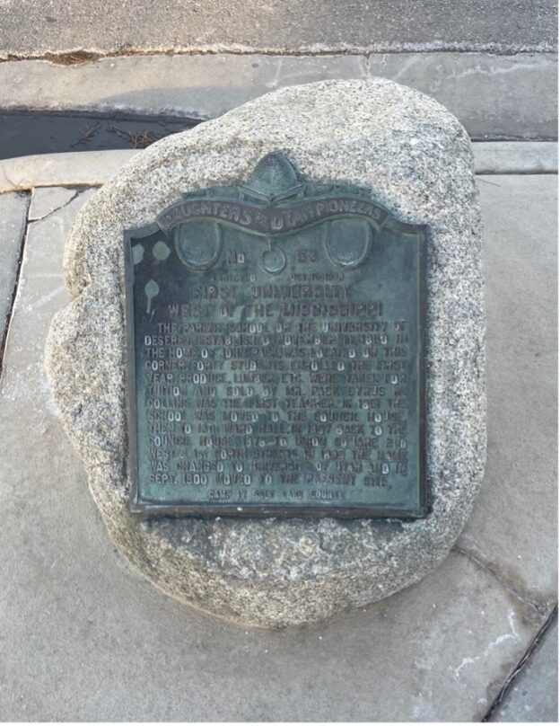
The parent school of the University of Deseret, established November 11, 1850 in the home of John Pack, was located on this corner. Forty students enrolled the first year. Produce, lumber, etc. were taken for tuition and sold by Mr. Pack. Cyrus W. Collins was the first teacher. In 1851 the school was moved to the council house, then to 13th ward hall, in 1867 back to the council house, 1876 to the union square 2nd west & 1st north streets. In 1892 the name was changed to University of Utah and in Sept. 1900 moved to the present site.
Camp 17 Salt Lake County”
Extended Research:
Not long after their arrival in the Salt Lake Valley, LDS church leaders and community members were eager to establish an educational institution that upheld and promoted the values of Latter-day Saints. On February 28, 1850, these hopes became a reality when an act passed by the General Assembly of the State of the Deseret (only one month after the assembly originally convened) created a school that came to be known as University of the Deseret.[1]
Originally, as noted by the marker, classes for the university were held in the home of John Pack, an early Mormon pioneer who is known to have helped settle the Salt Lake Valley. Pack himself notes in his journal entries, “I staid in the val[l]ey a fue [few] days and cut and hauled the first set of house logs that man ever hauled in this valley.”[2] The university was not immediately established upon the Mormons’ arrival, however, and LDS pioneers were often preoccupied with other responsibilities to the church and to the community. In 1848, not long after his arrival in the Great Basin region, Pack explains in his journal that he was redirected on a mission to France with elders John Taylor and Curtis E. Botton. Utilizing his knowledge from Europe, specifically his study of French educational institutions, Pack helped to structure the functioning of the University of the Deseret upon his return.[3]
Tuition was charged not in dollar amount; rather, Pack accepted natural resources like lumber as payment, and the resources were generally sold for profit. Classes in the Pack home were temporary, however, and, “…when the 13th ward schoolhouse was finished in the fall of 1851, the campus moved to this new building. About this time the university began to offer more resources and opportunities to students.”[4] Classes at the 13th ward schoolhouse unfortunately did not last long either due to financial constraints on the LDS population.
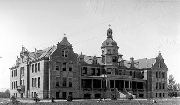
Photo Credit: J. Willard Marriott Digital Library
Due to economic insecurity of the Latter-day Saints in the formative years of their time in Utah, it was extremely difficult to continue classes at the University of the Deseret. In 1853, the university was forced to suspend operations due to insufficient funds. Despite this, classes were intermittently held at the Salt Lake City Council House, a building in downtown Salt Lake City used for government, civic, and community functions, until 1869 when John R. Park was hired as Principal and helped to establish a solid foundation for the university in Salt Lake.[5]
Park had been a practicing teacher in Draper since 1861 before he eventually became president of the University of the Deseret. Similar to Pack, John R. Park had toured Europe and used the enlightened modes of reason that he witnessed there to his advantage in order to effectively structure the education system in Utah.[6]
Still, Park was a baptized and practicing Latter-day Saint, and “like their lax attitudes toward separation of church and state, the Mormons did not make great efforts to distinguish between truth received from spiritual revelation or from empirical confirmation.”[7] The University of the Deseret and its curriculum was often centered around LDS doctrine, values, and industry. One example of unique study was the creation of a “Deseret Alphabet,” wherein “the Mormon-founded University of Deseret developed and promoted an alternative phonetic alphabet, modeled partly on Pitman shorthand.”[8] This contributed to the difficulty of attracting federal funding for the educational institution, due to overall negative attitudes towards Mormonism and efforts to contain the spread of LDS teachings. In the 1890’s, the University of Deseret began to adopt more secular teachings and policies, which highlights the contradiction between dominating religious authorities and the need for federal funding, which ultimately pushed the university to abandon hardline religious rhetoric. One such measure taken by the university was “In 1892, four years before statehood, an
Photo Credit: J. Willard Marriott Digital Library
amendment to the University of Deseret charter changed the name to the University of Utah.”[9] “Deseret” was a term taken from the book of Mormon and said to mean “honeybee.”[10] It was ultimately tossed out in favor of the US territorial name. This name change implied loyalty to the nation as opposed to Mormon religious authority, which helped establish good relations between the university and the US federal government.
Two years after the university’s name was formally changed to the “University of Utah,” congress ceded land from Fort Douglass which was established during the Civil War to the University for study and research purposes. “In 1894, Congress passed an act granting the university sixty acres of the land. Thirty-two more acres were granted in 1906 and another sixty-one in 1934.”[11] To this day, the University of Utah remains on the east bench of Salt Lake City.
This hallowed place was dedicated on August 28, 1890 by President Wilford Woodruff for all the nations in the isles of the seas, the Polynesian pioneers, their descendants and the faithful church leaders who left their home in the mid 1800’s and migrated to this gathering place in Zion to be married in the holy temple for time and eternity.
For 28 years (1889 – 1917) Iosepa was their home. In spite of the climate, isolation, loneliness, sickness, hardship, and death, their faith and courage never faltered. They overcame the cold winter, the summer heat, enjoyed the new life of spring and the bounteous harvest of the fall.
Their native songs and dances filled this beautiful valley, which they made “bloom as a rose” with love and aloha. A few remained in Utah, some on this consecrated spot, while the rest returned home to their beloved isles of the sea. The seeds of our Polynesian pioneers bore fruit in Hawaii – the Laie Temple, Brigham Young University – Hawaii, and the Polynesian Cultural Center. Holy temples stand firm in New Zealand, Western Samoa, Tonga, and Tahiti as monuments to the testimonies of the faithful Polynesian pioneers. We close this memory with their song of love:
Iosepa kuu home aloha
Iosepa kuahiwi ika nani
Iosepa ka home no ka’oi
Iosepa my home of love
Iosepa with it’s beautiful mountains
Iosepa my best home
DONORS
THE FIRST PRESIDENCY OF THE CHURCH OF JESUS CHRIST OF LATTER-DAY SAINTS PRESIDENT EZRA TAFT BENSON • GORDON B. HINCKLEY • THOMAS S. MONSON • PRINCESS ABIGAIL KEKAULIKE KAWANANAKOA • POLYNESIAN CULTURAL CENTER LAIE, HAWAII – BOARD OF DIRECTORS & EMPLOYEES • IOSEPA HISTORICAL SOCIETY LAIE, HAWAII • IOSEPA HISTORICAL ASSN, SALT LAKE CITY, UTAH • AL HARRINGTON FAMILY & FOUNDATION • RIVERTON 6TH WARD A.P.Y.M. + Y.W. 1988-89 • SKULL VALLEY RANCH CO. & EMPLOYEES • ZIONS SECURITIES CORP., LAIE, HAWAII • SALT LAKE MONUMENT CO. – MIKE ELLERBECK + FAMILY • MONTEREY SCULPTURE CENTER – CHARLES L. FISCHER • SCULPTOR–DR. JAN G. FISHER • HISTORIAN – DR. DENNIS ATKINS • ELDON P. & RUTH J. MORRELL • NORMAN & NANCY SWALLIE & CHILDREN RALPH & BETTY A. MAUGHAN & FAMILY • BERNICE W. THOMAS • IRMA W. MACDONALD MALU & CUMA S. HOOPIIAINA • JOSIAH, GEORGE, WILLIAM & CAROLINE HUBBELL & OHANA • ANDREW, FLORENCE, LOTTIE + JOHN KAMAUOHA & OHANA • EDWIN LEROY & TUSIPEPA KAMAUOHA & CHILDREN • LEROY PUKAHI + MALEKA MAHIAI + CHILDREN • LU & SCULLY ROGERS • GEORGE, WILLARD, BARBARA & CLIFFORD KEKAUOHA OHANA • WILLIAM AH QUIN & MABEL POEPOE & CHLN. • ANNIE KANAHELE TAUA & CHLN. • MARGARET K. LOPES VANAMAN + CHLN. • ELWOOD K. ALAPA & CECELIA HO’A • DESCENDANTS OF CLARENCE H. ALAPA, EDITH L. ALAPA, TUIA (OUR MOTHER) OHANA OF KUAHUA & KAAU A. FRANK & LA VINH MOELLER • CRAIG PETERSON • MARIE, MATILDA & STAN ALAPA OHANA • RALPH AND EMMA MAKAIAU & CHILDREN • LUCY PUKAHI AND WALTER TASHIRO & CHILDREN • MAGGIE BROAD & WILLIAM WALLACE OHANA • JOHN NAUAHI • LARRY AU + W. M. J. HART • CHARLES & HANNAH HALLIWELL & OHANA • WILLIAM J. AND PATRICIA CLARK • REP. LEE & BERNICE ALLEN
National Register
Utah Historic Site
IOSEPA SETTLEMENT CEMETERY
The Iosepa Community developed after Polynesian converts to the Mormon faith were employed as laborers by the Iosepa Agriculture and Stock Company in 1889. After numerous hardships, including bouts with leprosy, the colony attained a degree of financial independence and its population reached 228. In 1915 when the L.D.S. Church began to build the Hawaiian Temple, the need for “gathering” subsided. The Iosepa project was allowed to end and most of the settlers and their children returned to the Islands by 1917.
Division of State History N-38
Historical Marker Text (2):
ADMINISTRATION
HARVEY H. CLUFF 1889-1890 & 1893-1900
WILLIAM KING 1890-1892
THOMAS A. WADDOUPS 1901-1917
ORIGINAL SETTLERS
HARVEY H. CLUFF • FREDERICK A. MITCHELL • ELIHUE BARELL • FRANK W. MARCHANT • FRANCIS M. LYMAN, JR. • JOHN W. KAULAINAMOKU • KAPUKINI KAULAINAMOKU • JOHN MAKAULA • MARIA MAKAULA • KAPELA • CHARLES NAAU • JANE NAAU • EMILY S. NAAU • HAIKI • MOKE KALIMA • OLIVA ALAPA • JOSEPH KEKUKU • MILIAMA KEKUKU • HATTIE KEKUKU • IVY KEKUKU • VIOLA KEKUKU • EDWIN KEKUKU • PETER KEALAKAIHOUNA • PELEKANE KEALAKAIHOUNA • KAHAIANA KEALAKAIHOUNA • PETEROPIO KEALAKAIHOUNA • PIIPIILANI SOLAMONA • MOSES SOLAMONA • MAKAOPIOPIO • WILLIAM COLES • JOHN MAHUALII • ELIZABETH MAHUNALII • KALAWAI • KAPAINUI • JOHN K. N. MAHOE • HANAH MAHOE • LUCY MAHOE • DAVID MOKUILIMA • HOOKAIA MOKUILIMA • MARY MOKUILIMA • DAVID MOKUILIMA JR. • JOHN MAKAKAO • LUCY E. MAKAKAO • JOSEPH KEKUKU • WILLIAM K. HALEMANY • ELLEN HALEMANU • JAMES HALEMANU • JONATHAN NAPELA • MOCHAHO NAPELA • H. NAPELA • GEORGE KAMAKANIAU • V. MAHUNALII • KEALOHANIO KAMAKANIAU • GEORGE W. NIAU • HARVEY ALAPA • N. POMARIKAI
Here lie the honored Polynesian pioneers who have sealed their testimonies in the dust, that God lives, Jesus is the Christ, all the presidents of the church are prophets of God, and the Church of Jesus Christ of Latter-day Saints is true.
There are 79 graves in the cemetery. Only the names listed below are recorded. The rest are unknown, honored souls.
HARVEY O. ALAPA • MARY KAHOOHIG ALAPA • JOE ANTONE DRUMONDA • WILLIAM S. FREESTONE • PETER N. GEORGE • DORA KAILIAHI HALEMANU • EDWIN IOBA HALEMANY • EMMA PURCELL HALEMANU • GEORGE DELAWARE HALEMANU • MARIAH IHUNA HALEMANU • MATILDA KAMEHAILILANI HALEMANU • WILLIAM NIEWALANI HALEMANU • LEVI HANAKAEA • NAPAPALE HALEKAEU • CLARA KALIMAHII MAHOE HOOPIIAINA • CONNIE HOOPIIAINA • JOHN HOOPIIAINA • DAVID HALEAKALA HUBBELL • ELIZABETH KAAHU HAILI HUBBELL • JULIA KAAHU KAWAHINEKAWAI HUBBELL • EDWARD APUA IMAIKALANI • HARVEY K. IMAIKALANI • MARY POMAIKAI IMAIKALANI • JOSEPH K. O. KAIHIWAI • MARJORIE LAIE KAILIKEA • JOHN K. KAINI • KAPAINUI KALAVAO • JOHN KAMAUOHA • JOHN W. KAULEINAMOKU • EMILY KEALAKAIHOUNA • KEALAULA KEALOHA PAUOLA • HOSEA NAHINU OPIO KEKAUOHA JR. • MAKAOPIOPIO • JOHN. H. MAKAULA • MARIA K. MAKAULA • MOSES NAKUAAU • NAPAPALE • CECELIA NAWAHINI • ISAAC KEAHI NAWAHINI • MARTHA KAHOKUWAHILANI NAWAHINI • LEHI PAAHAO • BESSIE PETERS • ANNIE HULIA PUKAHI • SAMUEL KAUIHOU PUKAH • MARIA PAKAIAH MAKAIAU • KALEHUA MAKANOE • KEEPA MAKEHAU
PROJECT COORDINATOR – EDWIN L. KAMAUOHA
BUILT BY WILLING HANDS AND LOVING HEARTS
Historical Marker Text (3):
IOSEPA
HISTORICAL
SOCIETY
TIME CAPSULE
OPEN 28 AUGUST 1990
OPEN 28 AUGUST 2015
OPEN 28 AUGUST 2040
OPEN 28 AUGUST 2065
OPEN 28 AUGUST 2090
OPEN 28 AUGUST 2115
Historical Marker Text (4):
This lonely fire hydrant serves as a landmarker for the townsite of Iosepa, Utah, located on the desert floor between Cedar Mountain & the Stansbury Range in Skull Valley. Iosepa was named after Joseph F. Smith, 6th. President of the L.D.S. church. About 50 Hawaiians left Salt Lake City via Garfield by train, then by 20 wagons, to Grantsville, spent the night, arriving in Iosepa August 28, 1889.
The public square consisted of 16.9 acres, with 4 center streets, 132 ft. wide on four sides of the town park. A row of trees were planted in the center of each street. All the other streets were 66 feet wide and the blocks were divided into 4 lots, each containing ¾ acres.
All the streets had Hawaiian names. The original purchase consisted of 1,920 acres, of which 200 were under cultivation, the next two years accumulated to 5,273 acres. The water came from five streams collected in an open ditch put into a concrete conduit that furnished culinary water to each home. A fire hydrant and irrigation ditch went with each lot. The cemetery, about ½ acre, is located a mile northeast of the settlement. Iosepa won the state prize in 1911 for the best kept town and most progressive city in the state of Utah.
Only the Hoopiiaina family and J. Palikapee Nawahine remained in Utah. The rest returned home to Hawaii to settle and help build the Laie temple (1917-1919). Iosepa returned to dust, leaving a heritage of the faithful Polynesian pioneers, and closed a chapter in the great western American history.
IOSEPA HISTORICAL SOCIETY
EDWIN L. KAMAUOHA OHANA
PLAQUE & MARKER DONATED BY REX & PHYLLIS CROSLAND MAY 28, 1990
HOOPIIAINA OHANA
MALU, CUMA, WILFORD, CLIFFORD, CORY
Extended Research:
The Iosepa settlement was established by and for the Polynesian (mainly Hawaiian) members of the Church of Jesus Christ of Latter-day Saints which wished to live in Utah. It was founded with the arrival of 56 settlers to the site on August 28, 1889 and was abandoned by 1917.1 The town was settled out of a desire to relocate Polynesians in Salt Lake City to somewhere outside of the city. This was spurred on growing animosity towards Polynesians which was largely the result of controversy over Polynesian applications for American citizenship as well as fears over a rumored leprosy outbreak among native Hawaiians.2
Iosepa residents pickup up goods at Timpie Station Photo Credit: Utah State Historical Society (accessed on 3.2.22)
The colony was originally settled as a joint stock company incorporated as the Iosepa Agriculture and Stock Company, being owned by the L.D.S. Church. Harvey H. Cluff was the president of the corporation and manager of the company, while a person by the name of I. W. Kauleinamoku was the leader of the Polynesian Mormons. The land was dedicated by then L.D.S. Church President Wilford Woodruff on August 28, 1890, exactly one year after colonization, as a “gathering place for the natives of the islands of the sea.” Contrary to the story told on the marker, Iosepa was not self-sustaining and relied heavily on the L.D.S. Church to cover expenses, likely due to its isolation (The closest settlement to Iosepa, Milton, was about 40 miles away. After 1906, Timpie Station, a station at which trains stopped only if signaled to do so, was established, but it was still roughly 15 miles north of Iosepa). Furthermore, the colony saw a number of crop failures due to the climate of the region. This, combined with the scorching heat of summer, the freezing cold of winter, and disease took a massive toll on the settlers.3
Iosepa residents in front of one of the original homes Photo Credit: Utah State Historical Society (accessed on 3.2.22)
Despite these setbacks, life in Iosepa was reportedly pleasant. The L.D.S. Church was incredibly important to the colony and as such, the residents followed a schedule of annual holidays, including their own version of Pioneer Day, celebrated on August 28, and Church leaders visited the colony often. The diversity of cultures in the settlers could be seen especially in their festivities. Settlers prepared traditional Hawaiian food which was eaten alongside Euro-American food and eventually, the practices of the colony became unique in Utah while differing greatly from their Polynesian origins.
Welcome sign outside Iosepa cemetery
The people of Iosepa also made the education of all residents a priority, eventually hiring a teacher from outside the town. Additionally, the town was designed to provide enough space for everyone as well as to make freshwater available in every home.4 This can be seen in the townsite plat that was filed at the Tooele County Courthouse on July 31, 1908 based on the original townsite survey conducted by Frederick A. Mitchell and Francis M. Lyman.5
The historical marker within the Iosepa cemetery was dedicated on August 28, 1989, 100 years after the town’s founding, by then L.D.S. Church President Gordon B. Hinckley. All that remains of the settlement is the cemetery and a fire hydrant. The settlement reached a peak population of 228 in 1915 but was gradually depopulated as the L.D.S. Church began to build the Laie Temple in Hawaii and most of Iosepa’s residents chose to return to Oahu to assist in the Temple’s construction.6
[1] Dennis H. Atkins, “A History of Iosepa, the Utah Polynesian Colony,” 1958
[2] Matthew Kester, “Race, Religion, and Citizenship in Mormon Country: Native Hawaiians in Salt Lake City, 1869-1889,” Western Historical Quarterly 40, no. 1 (2009), 52; Matthew Kester, Remembering Iosepa: History, Place, and Religion in the American West (New York: Oxford University Press, 2013).
[3] David L. Schirer, “Iosepa,” Utah History Encyclopedia, 1994
[4] Dennis H. Atkins, “A History of Iosepa, the Utah Polynesian Colony,” 1958
[5] “Big Event for Iosepa Colony,” Deseret Evening News, September 1, 1908, 5.
[6] Scott Lloyd, “Iosepa Memorial Honors Utah’s Hawaiian Settlers,” Deseret News, August 29, 1989; Dennis H. Atkins, “A History of Iosepa, the Utah Polynesian Colony,” 1958
Kester, Matthew. “Race, Religion, and Citizenship in Mormon Country: Native Hawaiians in Salt Lake City, 1869-1889.” Western Historical Quarterly 40, no. 1 (2009): 51–76. http://www.jstor.org/stable/40505603.
Kearns~St.Ann’s Historic Site maker Photo credit: Pauline Simonson
This eclectic Chateauesque style building was constructed in 1899 by the Roman Catholic church. It was designed by Carl M. Neuhausen, architect of the Thomas Kearns Mansion and the Cathedral of the Madeleine, both located on South Temple Street. Bishop Lawrence Scanlan of the newly formed Salt Lake Diocese began acquiring land for the orphanage but encountered financial problems. Jennie Judge Kearns, wife of mining magnate and U.S. Senator Thomas Kearns, donated $55,000 to purchase the land and cover the entire cost of construction.
The Kearns~St. Ann’s Orphanage, operated by the Sisters of the Holy Cross, served the social, religious and educational needs of many children for over fifty years. The children shared responsibility in the total operation of the facility, with the expectation of accounts and records. The orphanage was converted to a parochial school in 1954, officially known as St. Anns’s School, and had an initial enrollment of 240 students from kindergarten to fourth grade. The Sisters of Charity of the Incarnate Word assumed leadership of the school at the time. Each year thereafter an additional grade was added until all eight grades were included in the school. In anticipation of the school’s restoration in the 1900s and to symbolize its link with the past, it was renamed Kearns~St. Ann School.
Marker placed in 1992
Other Markers on the Kearns~St. Ann’s Building
(Text 1)
With deep gratitude and in loving memory of Jane Finn McCarthey, whose devotion to children, to Catholic education, and to Kearns~St. Ann School was the embodiment of Christian Service and Love. 2001
Jane Finn McCarthey marker Photo credit: Pauline Simonson
(Text 2)
1953 1997
To the Sisters of Charity of the Incarnate Word whose devotion to Kearns~St. Ann School instilled in children lasting Christian values.
Sisters of Charity of the Incarnate Word Photo credit: Pauline Simonson
(Text 3)
To the Sisters of The Holy Cross whose devotion to St. Ann’s inspired in little children the one and only hope.
A M D G
Placed here by the descendants of the late Senator and Mrs. Thomas Kearns
Sisters of The Holy Cross marker Photo credit: Pauline Simonson
(Text 4)
Kearns
St. Anns Orphanage
Erected 1899
Kearns marker Photo credit: Pauline Simonson
Statue of Lady of Beauraing Belgium Marker Text:
Our Lady of Beauraing Belgium appeared 33 times from November 29, 1932 to January 3, 1933. In this statue is a piece of the tree she touched.
Kneel and Pray.
Our Lady of Beauraing Belgium marker Photo credit: Pauline Simonson
Our Lady of Beauraing Belgium statue Photo credit: Pauline Simonson
Extended Research:
In 1891, Bishop Lawrence Scanlan established the St. Ann’s Orphanage. This original orphanage was extremely small and did not successfully meet the needs of the Sisters of the Holy Cross running the orphanage. In 1895, land became available for Bishop Scanlan to purchase for a new orphanage to be built; however, he did not have sufficient funds so an annual fair was held to raise funds. Bishop Scanlan reached out to many people for help and Mrs. Thomas Kearns, the wife of Park City mining millionaire Thomas Kearns, answered and donated $55,000 for the building of a new orphanage.1
Bishop Scanlan selected Carl M. Neuhausen to design the new St. Ann’s Orphanage. Carl M. Neuhausen was born in Germany. Carl M. Neuhausen was a well-known architect in Utah. He included a unique chateâuesque renaissance style in his buildings. He primarily designed his buildings for the Catholic Church of Utah. His designs include the Kearns St. Ann’s Orphanage, the Cathedral of the Madeleine, the Kearns Mansion and the Carl M. Neuhausen House.2
In 1899, workers laid the cornerstone of St. Ann’s Orphanage and they completed the building the following year. The St. Ann’s Orphanage was renamed Kearns~St. Ann’s Orphanage in honor and recognition of the generosity of Mr. and Mrs. Thomas Kearns. Once the orphanage was complete, it was put under the supervision of The Sisters of The Holy Cross. The orphanage housed upwards of 92 children ranging from five to fourteen years old. The orphanage soon became a functioning school for the children run by The Sisters of The Holy Cross. In 1918, Kearns~St. Ann’s Orphanage also became a day school for children who did not specifically live at the orphanage.3
At least some of the children who lived at the Kearns~St. Ann’s Orphanage recalled their time there as a positive experience and believe they received a quality education. In 1951 David Handrahan was an orphan at the Kearns~St. Ann’s. In a news article in Intermountain Catholic, David Handrahan looked back on his time at the orphanage fondly and thought it normal to grow up with so many “siblings” and considered himself lucky to have such caring nuns who gave him and other boarders unconditional love and who acted as parental figures.4 Other borders at the Kearns~St. Ann’s Orphanage recalled that outings to parks, Fort Douglass, theaters, and other schools were a common occurrence. The Sisters of The Holy Cross running the orphanage showed the children love that they would not have received otherwise and provided the children with an education that helped them to excel.
In 1953, due to the state’s expansion of the foster care system, Sisters of The Holy Cross stopped serving at the orphanage. One year later the orphanage closed and the transition from an orphanage to school began. The school was renamed St. Ann’s School. In September of 1955, the St. Ann’s School opened with 240 enrolled, which included students ranging from kindergarten to 4th grade. Each year a new grade was added until 8th grade was reached.5
In 1999 Catholic leaders oversaw a renovation of the school and renamed it back to Kearns~St. Ann’s School in honor of its history and in recognizing, again, the generosity of Mr. and Mrs. Thomas Kearns. Through the years, several plaques were added to the exterior of the building commemorating the Sisters of Charity of the Incarnate Word, the Sisters of the Holy Cross, and Jane Finn McCarthey. The Sisters of Charity of the Incarnate Word’s plaque states that it was placed for their devotion to Kearns~St. Ann School and instilling in children lasting Christian values. The Sisters of the Holy Cross’s plaque was placed in honor of their devotion to St. Ann’s and inspiring “in little children the one and only hope.” Jane Finn McCarthey’s plaque is a memoriam plaque placed to remember and forever thank her for her work at Kearns~St. Ann’s school. Jane Finn McCarthey was an educator who cared deeply for the children she taught and prioritized both education of the mind and spirit.
Standing in front of Kearns~St. Ann’s is a beautiful white statue of Our Lady of Beauraing Belgium. Our Lady of Beauraing Belgium is an apparition of the Incarnate Virgin Mary, who in the Catholic Church is the mother of Jesus, the son of God. Our Lady of Beauraing Belgium appeared 33 times to 5 children in Belgium from November 29, 1932 to January 3, 1933. Each time she appeared, the children reported being drawn to a kneeling position in front of Our Lady of Beauraing Belgium. She told the children to, “Always be good” and to, “pray, pray, pray.” There was much skepticism if Our Lady of Beauraing Belgium appeared to the children but on July 2, 1949, the Bishop of Namur approved the apparitions. Our Lady of Beauraing Belgium stands in front of Kearns~St. Ann’s with the plaque stating to “Kneel and pray.” To make the spot one of worthiness to pray to Our Lady of Beauraing Belgium, a piece of wood that she reportedly touched was placed at Our Lady of Beauraing Belgium’s feet. Our Lady of Beauraing Belgium is a beautiful reminder to the children at Kearns~St. Ann’s to continue to pray and be good, along with a reminder to educators and adults to trust the innocence and truth of children.6
Today the Kearns~St. Ann’s School is still operating and fulfilling its mission to educate children. St. Ann’s Church was built next to the school and serves as the parish and church for the school. The continuation of the church and school signifies its importance to the community.
St. Ann’s School Photo Credit: Kearns~St. Ann’s School accessed 3/2/2022
Early orphans at the Kearns~St. Ann’s Orphanage Photo Credit: Kearns~St. Ann’s School accessed 3/2/2022
Present-day Kearns~St. Ann’s School Photo credit: Pauline Simonson
1. Kathryn Callahanby and Nicole L. Thompson, “Sisters of the Holy Cross and Kearns-St. Ann’s Orphanage,” Utah Historical Quarterly vol. 78 no. 3, (Summer 2010).
3. Kathryn Callahanby and Nicole L. Thompson, “Sisters of the Holy Cross and Kearns-St. Ann’s Orphanage,” Utah Historical Quarterly vol. 78 no. 3, (Summer 2010).
5. Kathryn Callahanby and Nicole L. Thompson, “Sisters of the Holy Cross and Kearns-St. Ann’s Orphanage,” Utah Historical Quarterly vol. 78 no. 3, (Summer 2010).
Placed by: The National Register of Historic Places, Division of State History; Department of Agriculture, Forest Service; Grand County and the Moab Lions Club
GPS Coordinates: 38° 33′ 58.95″ N, 109° 18′ 15.91″ W
Photo Taken By: Aubrie Strasters
Photo Taken By: Aubrie Strasters
Historical Marker Text (1):
Photo of Marker Taken by: Aubrie Strasters
PINHOOK BATTLEGROUND
The Pinhook Battleground Site on Manti-La Sal National Forest encompasses an 80-acre area and features a 20-foot square plot, which is the location of the common grave of eight men who were killed in the Pinhook confrontation. The Pinhook Battle, one of the largest and bloodiest battles between Anglo Americans and American Indians to occur in southeastern Utah, took place in 1881. The fight resulted in the death of eight Colorado posse members, two Moab cattlemen, and an unknown number of American Indians. The dispute was fueled by competition over the land and resources of southeastern Utah and southwestern Colorado. The National Register nomination and early commemoration efforts of the site were undertaken by the Moab Lions Club.
Marker placed in 2010
Historical Marker Text (2):
Photo of Marker Taken By: Aubrie Strasters
Left Side:
PINHOOK BATTLE
Photo of Marker Taken By: Aubrie Strasters
This is scared ground. It is the last resting place of eight people killed during one of the bloodiest battles to occur between settlers and American Indians in the Four Corners area. At least five others lost their lives in the fight.
For Centuries, Utes, Paiutes, Navajos and their ancestors had depended on the land. They gathered plants for food and medicines, drank the water, and hunted the wildlife. The mountains were places of safety and spiritual power.
Settlers began arriving in the area during the 1870s. At first the two groups cooperated, but as more cowboys and miners arrived, competition for land and resources escalated. By 1881, little remained of Ute land in Colorado. Large cattle herds in Colorado and Utah threatened to destroy the water sources, land and wildlife essential to the Ute way of life.
Hostility grew out of competition. In May 1881, emotions reached a boiling point. The Utes and Paiutes were stealing and killing livestock in retaliation for losing their lands. Colorado settlers called for an Indian War that would force all Utes out of the state. At a cabin near Delores, Colorado, ranchers confronted Utes traveling with allegedly stolen livestock. Two posses tracked the group for over a month.
Photo of Marker Taken By: Aubrie Strasters
The fight began the morning of June 15, when 36 posse members caught up to the Indians three miles south of here near Warner Lake. The chaotic battle ended here in Pinhook Draw, where most of the Anglo causalities occurred. By the following day 10 Anglos and three Indians were found dead. This included two Moab cowboys who were in the area herding cattle. If more Indians died, their bodies were retrieved by their comrades and buried elsewhere.
In the end, Colorado Utes were forced onto reservations in southwestern Colorado and northeastern Utah. Utes in southeastern Utah were able to avoid being moved onto reservations and their descendants now live at White Mesa, South of Blanding.
Left side:
The Ute and Paiute band included 90 men, women, children, and hundreds of heads of livestock. Did they intentionally lead the posses to this place, where they could have an advantage in battle? Look around you. Imagine the Ute warriors on the hillside before you. What do you think?
Photo of Marker Taken By: Aubrie Strasters
The monument directly in front of you lists the names of the men buried here. It was originally dedicated Nov. 11, 1940 by Grand County and members of the Moab Lions Club. In 1998, the Lions Club had the site listed on the National Register of Historic Places.
Historical Marker Text (3):
Photo of Marker Taken By: Aubrie Strasters
IN MEMORY OF
THOSE WHO WERE
MASSACRED BY INDIANS
JUNE 15 1881
BURIED WERE
I.E.WILSON, A.R.WILSON,
H.TARTER, W.TARTER,
J.[?]EATON, G.TAYLOR,
T.CLICK, J.GALLOWAY,
ERECTED 1940 BY GRAND CO
Extended Research:
The La Sal mountains, known by the Navajos as Dził ‘Ashdlaii which translates to “Five Peaks,” have been a source of natural resources since the first humans arrived in the desert landscape that Grand County is known for. Among the red rock landscape sits a mountain range that has provided the water, wild life, vegetation and minerals needed to sustain cultures dating back to the Paleo-Americans, which is believed to be the first culture to call these mountains home.[1] Mormon missionaries arrived in 1855 and failed to colonize indigenous land due to tribal claims on the land. After finding mineral wealth in the mountains and decades of the government reducing native claims on their lands, the area saw its first permanent settlements of Ethno-European peoples in the 1870s.[2] These settlers consisted of farmers, cattlemen, miners and Mormon homesteaders.[3]
Though at first the newcomers and the indigenous inhabitants seemed to be able to share the resources that the mountains offered, more settlers followed which put strains on the area’s resources. Cattlemen drove off wildlife. Ranchers and farmers diverted and polluted water for increased land use. Subsequent settlers further encroached on indigenous territory.[4] Their impact on the natural resources became a problem for Ute and Paiute peoples as those societies had relied on the land for generations to supply them with all of life’s necessities. The encroachment disrespected sacred and culturally significant sites for those indigenous nations.[5]
In response, the Native peoples tried several tactics designed to drive the settlers away. They destroyed fences and cabins. They killed, stole or mutilated livestock and horses. They made threats towards the settlers and in some incidences fired at them.[6] White settlers demanded retribution on the Native peoples. They called for war against the tribes seeing it as a duty to their god to use the land for “progress” in the spirit of Manifest Destiny.[7] Where the settlers saw progress, the indigenous people saw destruction of their way of life.
The story to the lead up of the Pinhook Draw fight is disputed. There was an incident at the cabin of John Thurman near present day Dove Creek on May 1, 1881, and by the end of the skirmish two men and two horses were dead. The men were Dick May, who was at the cabin to buy horses, and John Thurman, whose body was discovered a half a mile from the cabin. Historians debate the reasons for this fight and who discovered the scene, which could have been a prospector, a cowboy, or a member of the Navajo Nation. According to the white settlers, the dispute started a few days prior when Utes who were involved at the dispute at the cabin were caught trying to steal Thurman’s cattle and were beaten by Thurman and sent away. They returned to the cabin that day in order to exact revenge on the person who had beat them.[8] The Utes’ account came from an interrogation which Indian Agents conducted in the aftermath of the Pinhook Draw fight. It stated that they had met May at the cabin where after answering the door, May threw one of the Utes to the ground and walked over to their horses and shot two of them. The Utes claimed they killed the two men out of anger after May’s actions.[9]
Photo Taken By: Aubrie Strasters
Whichever story is true, this incident is one of many believed by the white settlers to have been perpetrated by this band of Utes. In response, after several other ranchers reported having their livestock stolen and cabins raided, the settlers decided to form a posse to track down and exterminate the Ute band. The initial posse was formed in mid-May and consisted of 12 men, but once they found out how large the band of Utes was, they went back and reenforced their numbers to 25. At the same time another posse, from the mining town of Rico, formed with the goal to recover stolen property, but really their intent was to “fight Indians.”[10] The two posses combined for a force of about 65 men and left to attack the Ute band. By June 15, their numbers had dwindled to under 35 men due to disagreements between the members of the group but this was the first contact with the Ute’s herd. The Ute band had made camp near Warner Lake in the La Sal Mountains and spotted the approaching cowboys. The men from the 90 person Ute band began to prepare for battle and the women prepared to flee with the children.[11]
The posse chased the tribal members through the camp near Warner Lake and for a few miles afterward until they hit Mason Spring. The posse’s leader, Bill Dawson, sent six men ahead to scout out the Ute position. Jordan Bean was among the six and in a later interview he stated the instructions that Dawson gave them was to “overtake the Indians and make a stand on them, and that he would bring the rest as fast as possible.”[12] The Utes led the men into the start of Castle Valley where there are steep cliffs on both sides, giving the Ute fighters the high ground.
Photo Taken By: Aubrie Strasters
The Ute men began to open fire on the posse members below who sought shelter and returned fire. Though the remaining posse was only 150 yards from the fight the majority of them did not join their comrades. Jordan Bean was wounded, knocked unconscious and left on the battleground. When he came to, he made his way to a spring where he found part of the posse moving back onto the battleground the next morning. They took him back to camp to recover where he learned that 9 men were missing. The posse returned for a second day of fighting which ended with a total of ten posse members and two Utes left dead on the battlefield over the two days of fighting. Though the number of Utes who died in the battle and the skirmishes leading up to the event is disputed, it is estimated to have been around 20 indigenous deaths.
Photo Taken By: Aubrie Strasters
The Pinhook Draw Fight has been said to be one of the “largest and most tragic Indian-White confrontation ever in terms of numbers killed,” which may be true for the region.[13] However, over the course of western settlement a significant number of lives have been taken over the ideas of who has a right to use the land and the manner of use that qualifies as correct.[14] The multiple stories of the Pinhook Draw Massacre reflect differing conceptions of land, use, ownership, and access. By colonizing and engaging in violence, the Pinhook Draw Massacre reflects the historical and cultural distance between the La Sal mountains and Dził ‘Ashdlaii.
For Further Reference:
Firmage, Richard A., and Utah State Historical Society. A History of Grand County. Utah Centennial County History Series. 1996.
McPherson, Robert S. “Indians, Anglos, and Ungulates: Resource Competition on the San Juan.” In Northern Navajo Frontier 1860 1900, 51–62. University Press of Colorado, 2001. https://doi.org/10.2307/j.ctt4cgmhk.8.
Rusty Salmon, Robert McPherson, “Cowboys, Indians, and Conflict: The Pinhook Draw Fight, 1881” Utah Historical Quarterly Vol. 69, 2001, No. 1, 4-28
Tanner, Faun McConkie. The Far Country: A Regional History of Moab and La Sal, Utah. 1976.
Utah Daughters of the Pioneers. “Grand Memories.” 1972.
[1] Rusty Salmon, Robert McPherson, “Cowboys, Indians, and Conflict: The Pinhook Draw Fight, 1881” Utah Historical Quarterly Vol. 69, 2001, No. 1, 4-28
[2] Firmage, Richard A., and Utah State Historical Society. A History of Grand County. Utah Centennial County History Series. 1996
[3] “History: Grand County, UT – Official Website,” History | Grand County, UT – Official Website, 2022, https://www.grandcountyutah.net/387/History.
[4] Salmon, McPherson, “Cowboys, Indians, and Conflict,” 4-28.
[5] McPherson, Robert S. “Indians, Anglos, and Ungulates: Resource Competition on the San Juan.” In Northern Navajo Frontier 1860 1900, 51–62. University Press of Colorado, 2001.
[6] Salmon, McPherson, “Cowboys, Indians, and Conflict,” 4-28.
[12] Jordan Bean, “Jordan Beans Story and the Castle Valley Indian Fight,” Colorado Magazine 20 (1943): 19;
[13] Kathy Jordan, “Deadly Confrontation in Utah Took Place Shortly before GJ Incorporated,” Historic 7th Street, n.d., http://www.historic7thstreet.org/remembering/pdfs2/pinhook.pdf.
[14] William Cronon, Changes in the Land: Indians, Colonists, and the Ecology of New England (New York, NY: Hill and Wang, 2003).
In 1891 George Frary built a house on this 160-acre homestead. Six years later his wife Alice died and lies at rest in this burial site.
FRARY FAMILY
Father- George Isaac Frary B. Nov. 18, 1854 in Madison, Wisconsin
Mother- Alice Eliza Philips B. July 21, 1859 in New York Died Sept. 3, 1897
Children- Guy Prentis B. 1881 Grace May B. 1883 Lotti Ada B. 1886 Edgar Philips B. 1888 Dora Ide B. 1892 Frank Marvin B. 1894 Florence Hope B. 1897
George was stocky and extremely strong. Alice was frail, 5’2” with blue eyes, and very dark hair. Because of Alice’s ill health and George’s interest in sailing, this Desert Isle was chosen. The children were happy with many things to do, hiking the peaks, swimming in the lake and picking wild flowers. Their mother taught them well and precious times came when she played the organ and the family sang their favorite songs.
Every year a garden was planted and irrigated by a fresh spring. The barn and chicken coop were built in the gully. The house was rustic, gabled and built upon natural stone with one room. Soon a kitchen and bedroom were attached to the back. Every morning a flag waved in the breeze.
Alice’s health deteriorated. George went to the mainland for medicine. Upon returning about midnight, a storm capsized his boat and dawn found him half drowned, laying on the beach. The next day Alice died. She previously requested burial on the Island. This hallowed place was chosen at the edge of their orchard near the grain field. A small pink stone marks the grave. In autumn a shadow from Frary’s Peak touches this lonely spot and when a gentle breeze whispers through the sunflowers, you can almost hear the organ playing, while the family softly sings, “This is Our Desert Island Home So Dear.”
Extended Research:
This marker honors the memory of the Frary family who called Antelope Island home. George Frary moved to Utah from Wisconsin. It was in Wisconsin that George developed a passion for sailing while living close to Lake Superior. The ability to sail on the Great Salt Lake is what drew the Frary family to the area.[1] They built their 3-room cabin at the base of the highest peak on Antelope Island; this peak is now called Frary peak to honor the family.[2] George and Alice’s six children would play on and around the peak during the summer months.
Almost fifty years before the Frary family lived on the island, explorers were drawn to the Great Salt Lake and its islands. Determined to find where the Great Salt Lake emptied out into the Pacific Ocean, John C. Fremont explored the lake as well as its islands in 1843.[3] However, it was not until 1845 when he returned that Antelope Island got its name. Antelope Island was named for the animals that were found on the island.
Fremont and his crew searched in vain for a drainage outlet to the ocean and he rightly concluded that there wasn’t one. In 1843, they camped on what Fremont named Disappointment Island. Fremont and his crew were expecting to find resources, but they didn’t find anything on the Island, which is why Fremont named it Disappointment Island. In John Fremont’s narrative of his time on the Great Salt Lake, he goes into great detail about the vegetation and wildlife that lived on the various islands, but he never found any resources of significance to promote any kind of settlements on the lake islands.[4] It wasn’t the natural resources that drew the Frary family to the lake, it was the water levels that made it possible for George to sail and enjoy one of his favorite pastimes.
According to the signs that are posted around this marker, when the Frary family settled on Antelope Island, they established a small farm on which they grew wheat to sustain themselves. Besides wheat they had a tough time getting anything else to grow. The water conditions as well as grasshoppers made it difficult to grow fruits and vegetables. Aside from the few crops that they were able to grow, the roaming antelope that they were able to hunt for meat, there were also cattle during this time that roamed free on the island. George was able to make a living by herding the cattle that were living on Antelope Island.[5] When the family needed provisions, they would have to sail to Syracuse, the closest town. In 1891 Syracuse was just a small farming village which had a small general store as well as a post office, both of which offered the Frary family a chance to resupply and to stay connected to the outside world.
Photo by Schyler Fox
Before coming to Antelope Island, Alice Frary was not in the best health. It’s said that salt air surrounding the Great Salt Lake improved her health. After giving birth to their youngest child, Hope, Alice’s health started to deteriorate. When Hope was just 2 months old, Alice started having heart troubles. Determined to help, George sailed into town and made the trip to Ogden as this was the closet town that had a doctor. On the way back a wind kicked up and capsized his boat. He recounted that the only thing that kept him going was the thought of Alice being sick and needing to help her. Unfortunately, she passed away the next day. Her dying wish was to be buried on the island.[6] The reason for her passing is not known.
After the passing of Alice, George started venturing outside of his homestead. While never fully able to leave the island, he took his sailboat and started exploring more.[7] Aside from farming, there was also gold and copper ore to be found on Antelope Island. George Frary, along with three other prospectors started mining. At the height of this mining, they were getting four tons of copper ore to sell. In 1899, Frary and his partners incorporated their mining claims on the island. Many of the men had land claims that when right down to the waterfront.[8] With the land claims going down so far, they were able to take the ore straight to their boats and load up to be sold. This improved their profit since they owned everything and didn’t have to pay someone to move the ore and load it to be sold. George and his family stayed on the island until George’s passing in 1942 at the age of 88.[9]
Photo credit: Marriot Library (accessed on 04.04.2022)
The lake that the Frary family encountered looked quite different than the lake that we can visit today. The water level was higher than it is today. In the 1860s the Great Salt Lake was at its highest point of 4,211 feet above sea level.[10] This means that the shoreline would come right up to the road that the Frary family would travel to get to their homestead. Current Great Salt Lake water levels as of August 2021 are 4191 feet above sea level; the lake has shrunk by about 11 feet since the time that the Frary family built their home there.[11]
[9] “Homestead Family Left Lasting Legacy on Island,” Deseret News, October 29, 1992.
[10] Ted Arnow, “Water-Level and Water-Quality Changes in Great Salt Lake, Utah, 1847-1983,” Water-Level and Water-Quality Changes in Great Salt Lake, Utah, 1847-1983 § (n.d.).
Historical Marker Text (1): FIRST FREE PUBLIC SCHOOL The Territorial Legislature, February 1866 authorized the levy of a tax for the support of schools within each district. Pursuant to this act Mayor Leonard E. Harrington called a meeting and the majority of citizens of American Fork approved the plan. School opened in November 1867 with Jos. B. Forbes, E.A. Henroid, Editha Anderson and Elizabeth G. Griffith teachers. Wm. Greenwood, Wm. Paxman, James W. Preston, trustees. American Fork thereby became Torch Bearer of the present free school system.
Photo Credit: Trever Vallieres
Historical Marker Text (2): “When upon Life’s Path We Tread”, sang 25 lusty young voices as morning school bells called the students to order. Those lyrics to the tune “Hark, Listen to the Trumpeters”, from the old sunday school song book, were favorites of that school class. “When upon life’s path we thread, we come to many a place, where if not careful we will fall and sink into disgrace. So, my children one and all, please mind your parents dear and teacher, as you go through life then you’ll have not to fear. Through life’s journey…” “When the pioneers moved to the west, with courage strong they met the test. They pushed their handcarts all day long as they pushed they sang this song. For some must push and some must pull as we go marching up the hill; so merrily on our way we go until we reach the valley-o”
Extended Research:
Education is the cornerstone of any society or civilization. The education that society has reflects the societies culture, values, and religious practices. This is as much true today as it was 160 years ago. The story of education in Utah Territory during the 19th century is a unique story embodying varying ideas of what education should be doing for the population. In 1867 the first public school supported by levied taxes opened in American Fork.[1] Creation of the school came shortly after President Brigham Young publicly stated that a change in the education system was necessary for the betterment of children.[2] Schools in Utah Territory prior to this, largely operated with donations made by people in the community and were often taught in ward houses that belonged to the Church of Jesus Christ of Latter-day Saints.[3] Since schools in Utah Territory were largely supported through donations teachers were paid with very low wages and in some cases through other donations such as produce.[4] A tax supported school allows for more schoolhouses to be built and teachers to be hired thus increasing the amount of students that can be taught. What led to this change? And did it really become the torchbearer of the late 19th century education system that the Daughters of Utah Pioneers claim it to be?
In 1867 a Desert News article outlined the major changes that occurred in Utah Territory that furthered the support of public schools and education as a whole. Within the article, the author came to the conclusion that because Mormons had now settled on the land for a couple of decades, they could spare the children used for labor and allow them to attend schools to further their scholastic and educational goals.[5] The societal shift and push for more schooling was supported by the governor of Utah territory at this time. In the governor’s message posted in newspapers in 1867 the governor gives his support for widespread public education. In his message he says
…yet such steps as are [practical] should be taken towards making the means of education free to all children within the territory.[6]
Education in Utah Territory during the 19th century was a widely debated subject. Although everybody agreed that education was important not everybody agreed on how to go about education. In fact, there was a division even amongst Mormons.[7] Some Mormons feared that prolonged exposure to secular schools would persuade their students away from Mormonism and away from the end goal of the Latter-day Saints which was the building of the kingdom of God.[8] Other Mormons such as Brigham Young believed that education in secular schools was a gamble worth taking in order to provide the Latter-day Saint community with educated individuals who were capable of providing different skills to the community.[9] The non-Mormon community feared that Mormon controlled schools would become a place where the Mormons could proselyte their religion.[10] The creation of the first tax levied public school in Utah Territory is a good example of how these varying ideas came into practice during the 19th century.
These varying ideas are important for understanding how and why schools were created during the 19th century in Utah Territory. The schools during this time used LDS scriptures, including the Book of Mormon, as supplementary teaching resources to traditional textbooks.[11] As early as 1846 Brigham Young, the leader of the Church of Jesus Christ of Latter-day Saints instructed bishops to establish schools in each ward – the LDS church’s term for region based meeting houses.[12] The teachers at the schools were often picked by bishops and other leaders of the church, people they knew could be trusted to teach students the proper LDS values in order to create “good citizens” according to the Mormons.[13] The non-Mormon population believed that the current state of education in Utah Territory involved too much church and state overlap. This is most evident from the liberal political party nominee, M. W. Ashbrook. In 1870 Ashbrook wrote a letter about his concerns for the current state of education in Utah territory.
Every child brought into being has rights which no honorable public will ignore, and one of the most sacred of these rights is the right to a liberal education-liberal in the broad acceptation of the term where knowledge is not distilled from the pest brain of a theocratic leper [Brigham Young].[14]
The language Ashbrook uses in this letter is quite aggressive and demonstrates just how frustrated the non-Mormon population was with the public education system in Utah Territory.
Not much is written about the American Fork public school, but evidence suggests that the newly built public school did not ease the concerns of the non-Mormon population. Although the school was made public to all children in the community and supported by taxes from all citizens living in the community it still used the Book of Mormon as a teaching tool and still fostered the development of Latter-day Saint values and principles.[15] As a reaction to the de facto Mormon public school the Protestant population set up their own schools supported by evangelical institutions to offer alternative options that were not controlled by the Latter-day Saints.[16]
Being the first tax supported public school in Utah Territory is indeed a significant step and change in the status quo of 19th-century Utah education. However, it was just the beginning of a very long story and battle between very different cultures. It did not achieve what the minority religious population wanted it to achieve, and it certainly seems that the non-Mormon population would disagree with the claim that it was the torchbearer of the late 19th century Utah education system.
[3] Frederick S. Buchanan, “Education among the Mormons: Brigham Young and the Schools of Utah,” History of Education Quarterly, Vol. 22, No. 4 (Winter, 1982), 439.
[7] Thomas W. Simpson, American Universities and the Birth of Modern Mormonism, 1867–1940, (The University of North Carolina Press Chapel Hill, 2016), 2-3.
[14] Frederick S. Buchanan, “Education among the Mormons: Brigham Young and the Schools of Utah,” History of Education Quarterly, Vol. 22, No. 4 (Winter, 1982), 440-441.
Buchanan, Frederick S. “Education among the Mormons: Brigham Young and the Schools of Utah,” History of Education Quarterly, Vol. 22, No. 4 (Winter, 1982), pp. 435-459
Placed by: Goodyear Tire & Rubber Company, June 1972
GPS Coordinates: 40.77953, -113.83226
Photo 1 by John Henderson, January 29, 2022.
Historical Marker Text:
Photo 2 by John Henderson, January 29, 2022.
WELCOME TO THE BONNEVILLE SALT FLATS
And Utah’s Famed Measured Mile – Site of World Land-Speed Record Runs
Utah’s famed measured mile is located approximately seven miles beyond this marker, well in front of the mountains you see on the horizon. The elevation along the course is approximately 4,218 feet above sea level. *** The total length of the course that includes the measured mile varies from year to year, but for recent runs it has been laid out in a path 80 feet wide and approximately ten miles long, with a black reference stripe down the middle. Due to the curvature of the earth, it is impossible to see from one end of the course to the other. *** Timing of world land-speed record runs is under the jurisdiction of the United States Automobile Club. World land-speed record times represent an electronically-timed average of two runs over the measured mile, within a one hour time period – one run in each direction. *** The first world land-speed record on the Bonneville Salt Flats was set on September 3, 1935, by Sir Malcolm Campbell. His speed was 301.13 miles per hour. *** Craig Breedlove holds the honor of being the first man to go faster than 400, 500, and 600 miles per hour. His record of 600.601 miles per hour, set on November 15, 1965, was finally broken on October 23, 1970, by Gary Gabelich. *** Gabelich’s new record is 622.407 miles per hour. Both Gabelich’s rocket engine ‘Blue Flame’ and Breedlove’s jet-powered ‘Spirit of America’ were equipped with specially designed inflatable tires, pre-tested to speeds in excess of 800 miles per hour.
Known for hosting land-speed record attempts, the Bonneville Salt Flats are a geological and geographical wonder. Located near the shared border of Nevada and Utah in Tooele County, Utah and spanning 30,000 acres, this salt pan is a remnant of the ancient Lake Bonneville, which existed 32,000 to 14,000 years ago and was originally part of a larger body of water that existed during the geological Gelasian Stage of the Pleistocene Epoch, also known as the “Last Ice Age”.[1] Lake Bonneville covered an area of approximately 2,300 square miles and included the area now known as the Great Salt Lake and Great Salt Lake Desert.[2]
Euro-American explorers conducted reconnaissance of the area encompassing the Bonneville Salt Flat as early as 1833. Ordered by Captain Benjamin L.E. Bonneville, Pacific Coast explorer Joseph R. Walker may have encountered some of what remained of Lake Bonneville during his journey to California.[3] The Bartleson-Bidwell company, captained by John Bartleson and carrying the first white woman and child through Utah, would skirt the western edge of the desert on their way to California in 1841.[4] However, the first recorded crossing of the Great Salt Lake Desert region came 20 years later in 1845, when Captain John C. Fremont, accompanied by scouts Walker and Kit Carson, surveyed the area.[5]
Still, the Bonneville Salt Flats itself remained virtually untouched due to being too harsh an environment for early settlers and wagon trains passing thru to California. But western industrial development and modernization soon entered Tooele County: first, the permanent establishment of the telegraph in 1861; telephone services in 1905; and the first permanent crossing of the Bonneville Salt Flats by the Southern Pacific Railroad in 1910.[6] These developments gave rise to increased mining operations and travel through the county in the twentieth and twenty-first centuries.
The Bonneville Salt Flats may be known best for one reason: speed. In 1907, Bill Rishel began promoting the flats as a place for racers to drive their automobiles, following others’ attempts to set land-speed records in Paris, France and Daytona Beach, Florida. Although many initially refused the idea of racing on the flats, news of Utahn Ab Jenkins’ race against a locomotive train in 1925 and 24-hour endurance race in 1932 eventually spread, and in 1935, drivers from England arrived to break Jenkins’ records. In July 1935, John Cobb broke over 64 records on the flats, including Jenkins’ endurance record. In September 1935, Sir Malcolm Campbell, who had previously set the world land-speed record at Daytona Beach, broke his old record on the flats with a new land-speed record of 301.1202 miles per hour.[7] The race was on (so to speak) and the flats have seen racers come to be the new driver to best. The impacts of natural climate (i.e., wind, excess rain) and human events (i.e., commercial industries, interstate transportation) have been grounds for scientific and government concern. Increased temperatures, evaporation, and manmade boundaries have permanently affected the natural ecosystem and depleted the salt in and around the Bonneville Salt Flats, despite continued restoration efforts.[8] Several federal and local organizations, including the U.S. Bureau of Land Management, have joined forces to restore and preserve the flats.
Photo 5 by John Henderson, January 29, 2022.
[1] C. Claiborne Ray, “The Great Salt Flats,” New York Times (New York City, NY), November 30, 2004; Brenda B. Bowen, et al., “Temporal dynamics of flooding, evaporation, and desiccation cycles and observations of salt crust area change at the Bonneville Salt Flats, Utah, Geomorphology 299 (2017): 1; “GSA Geologic Time Scale,” Geological Society of America, updated August 2018.
[2] Ouida Blanthorn, Utah Centennial County History Series: A History of Tooele County (Salt Lake City: Tooele County Commission, Utah State Historical Society, 1998), 5.
Blanthorn, Ouida. Utah Centennial County History Series: A History of Tooele County. Salt Lake City: Tooele County Commission, Utah State Historical Society, 1998.
Ray, Claiborne C. “The Great Salt Flats.” New York Times (New York City, NY), November 30, 2004.
Warning: Attempt to read property "comment_ID" on null in /home/wpaulree/UtahHistoricalMarkers.org/wp-content/plugins/subscribe-to-comments/subscribe-to-comments.php on line 81
Warning: Attempt to read property "comment_ID" on null in /home/wpaulree/UtahHistoricalMarkers.org/wp-content/plugins/subscribe-to-comments/subscribe-to-comments.php on line 81
Warning: Attempt to read property "comment_ID" on null in /home/wpaulree/UtahHistoricalMarkers.org/wp-content/plugins/subscribe-to-comments/subscribe-to-comments.php on line 81
Warning: Attempt to read property "comment_ID" on null in /home/wpaulree/UtahHistoricalMarkers.org/wp-content/plugins/subscribe-to-comments/subscribe-to-comments.php on line 81
Warning: Attempt to read property "comment_ID" on null in /home/wpaulree/UtahHistoricalMarkers.org/wp-content/plugins/subscribe-to-comments/subscribe-to-comments.php on line 81